Forum:Territory application/AR060-10 Odeka and Maples
- Please fill in the information below to make a territory request.
| Territory ID and proposed name | |
|---|---|
| The Territory ID (from OpenGeofiction:Territories, e.g. AR123a) and proposed name of the country |
ID: AR060-10
Full name: Odeka and Maples
| Physical geography | |
|---|---|
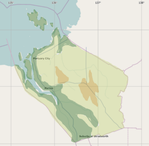
| An overview of climate, topography and landscape of the country. With the exception of Beginner territories, you should always create a sketch map to illustrate & explain your plans. You can add a link to this (hosted on imgBB, Postimages or similar, but not imgur.com) |
Natural geography:

The territory would be cut by the Odeka River and Valley, while the eastern part of the state would resemble the Great Plains Region around Regina, by being a higher altitude but still pretty flat.
The climate would bemperate but drier than other coastal provinces like Ingerish Asperia.
 | Human geography |
|---|---|
| A brief description of the territory demographics, economic development, land occupation, infrastructure and mapping style |
The population would be concentrated in the eastern banks of the Odeka Valley, with a very high difference of density between the largest cities and towns and the countryside.
With a population of around 4.3 Million People, the largest population area would be Marvin Metro, with 2.1 Million, followed by the Suburbs of Stradworth with 400k, and followed by a portuary city with a metro population of 1.1 Million.
The main economic base for the state would be agriculture, having a big economic divide, with the eastern part of the state being poorer.
| History & culture | |
|---|---|
| A brief description of the intended culture and language |
Indigenous people would have formed small mound cultures and be semi-permanent, when Ingerish Colonizers arrived they would have firstly colonized the river banks, being just a path to the lakes, the Odeka River would have few bigger town across its banks.
Colonization history and later history would be coordinated with the other members of Deodeca.
| Past mapping | |
|---|---|
| To support your request provide links to areas of OGF mapping which showcase your mapping skill. Mapping relevant to the requested theme & geography is especially useful. | |
| The {{coord}}, {{node}}, {{relation}} or {{scalehelper}} templates can optionally be used to link to the OGF map - they result in nicely formatted links. Or you can paste in a URL. |
Geography -
Great Deep National Park - A canyon region in northern Atascadera
https://opengeofiction.net/#map=11/-30.1916/134.9558&layers=B
Tapor Lake System - A Marsh Lake Formation on western Atascadera
https://opengeofiction.net/#map=12/-30.9525/134.1583&layers=B
Dustwonder Reservoir
https://opengeofiction.net/#map=10/-31.5364/136.9965&layers=B
Infrastucture -
Cassel Downtown Region
https://opengeofiction.net/#map=17/-31.04195/134.20158&layers=B
Brownstone Street Layout
https://opengeofiction.net/#map=13/-40.2875/159.8362&layers=B
| Username & date | |
|---|---|
| Sign and date the application by typing four tildes (~~~~) without spaces or "nowiki" tags. |
Davieerr (talk) 04:27, 12 February 2023 (UTC)
 | Discussion |
|---|---|
| Discussion for clarification & decision |
- Just to clarify, is this a request for a third territory or would this be a swap for one of your existing territories? I know you've recently been doing something of a "reboot" for parts of your FSA state, and I want to make sure any additional territory wouldn't come at the expense of not being able to focus on the territories you already have. --TheMayor (talk) 20:18, 12 February 2023 (UTC)
- This is not a swap, but a request for a third territory. As for your worry about my capability to have a third territory, I completly understand, so here goes a small explanation: The reboot of Atascadera was made because I felt my old mapping didn't satisfy me, the new layout is going slower, because I want to be sure that I won't regret these changes. With that in mind, I'll let you be the judge of if you believe I can handle a new territory or not, however, I'll let it be known that I don't think this would be too much for me.-- Davieerr (talk) 02:09, 13 February 2023 (UTC)
- Note, this is our starting point on second, and additional territories: Additional territories are held to strict standard. Currently mapped territory must be at least 50% 'full' - it's hard to meet this, especially with the density of mapping in TA104. Thanks/wangi (talk) 16:01, 13 February 2023 (UTC)
| Territory application closed | |
|---|---|
| Application closed pending additional work on current two territories. --TheMayor (talk) 21:54, 16 February 2023 (UTC) | |
| This application can be reopened at any time as a territory swap request, or it can be reopened at a later date when the current two territories are more comprehensively mapped. |