

Forum:Territory application/UL08a - Cassany
 | Territory ID and proposed name |
|---|---|
| The Territory ID (from OpenGeofiction:Territories, e.g. AR123a) and proposed name of the country |
UL08a∈⊾ƨ - Cassany (downsizing/exchanging from UL11a∈⊾ƨ)
Edit: 6 July 2026: Rewritten
I've been a little dissatisfied and demotivated with Almetia for some time. After giving it some time, and of course giving some mapping a go, I've decided that I would like to develop something different instead of persisting on Almetia.
 | Physical geography |
|---|---|
| An overview of climate, topography and landscape of the country. With the exception of Beginner territories, you should always create a sketch map to illustrate & explain your plans. You can add a link to this (hosted on imgBB, Postimages or similar, but not imgur.com) |
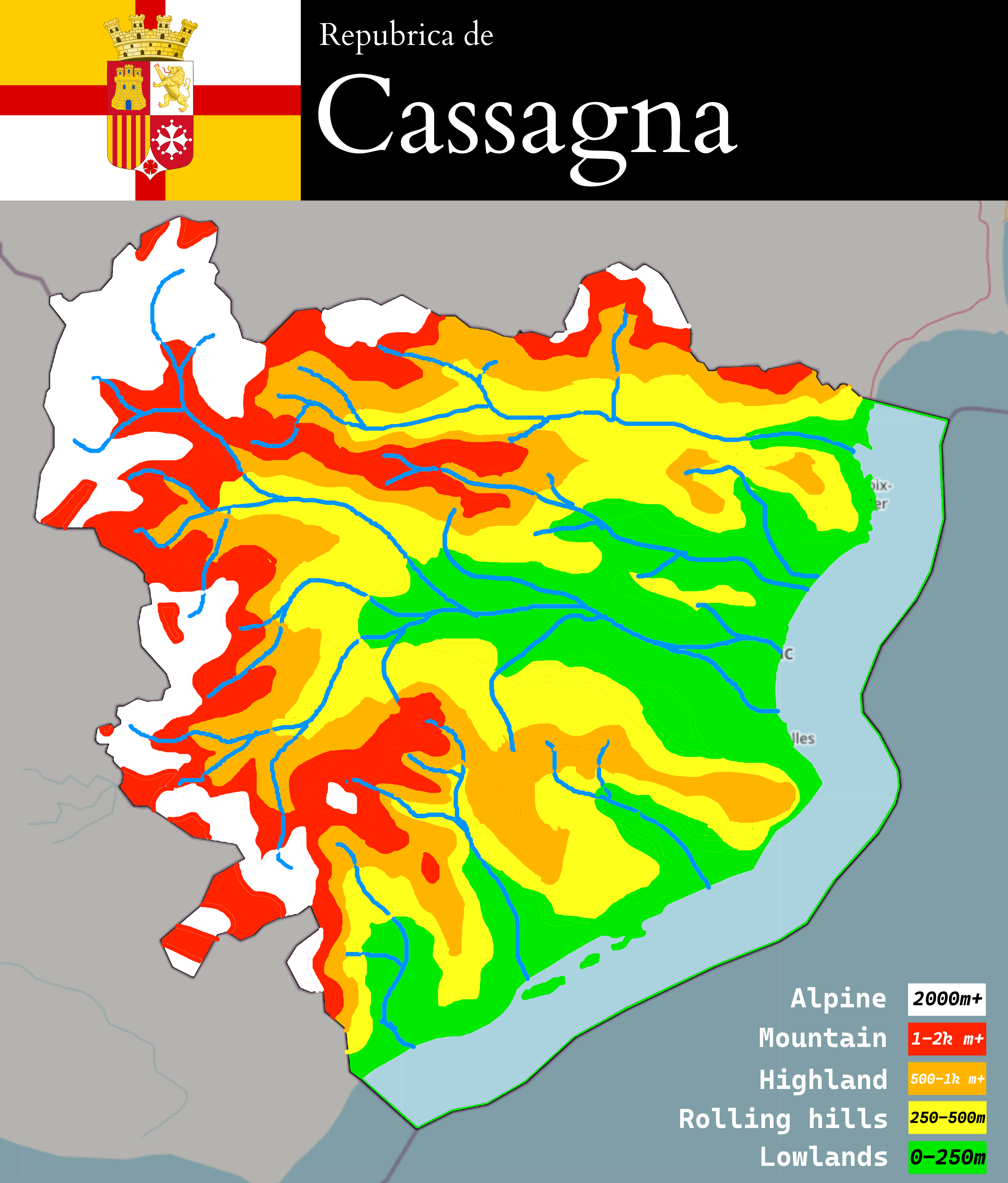
Topography/Landscape
Cassany, roughly, would slope from the Valadian (northwest) and Laurentine (southwest) mountains as a part of the wider Catens range in the west to the lowlands of the east, especially around the Baìsa river basin in the east-central region of the country. A ridge of gentler highlands separates the southern quarter of Cassany (Metessa) from the remainder.
Roughly half of the country, generally in the east and centre, will be arable, low-lying land ranging between plains and very mild hills; this is where the vast majority of the country lives (vaguely resembling the Rhône Basin, the lowlands north of the Pyrenees, and the Languedoc lowlands). The north, around the province of Aurence, among other areas would be characterised by rolling hills and nearly-mountain type ranges. The west approaches alpine zones and stretches into cold continental and tundra climates (as comparable to the Pyrenees and Massif central), and would be mostly sparsely populated.
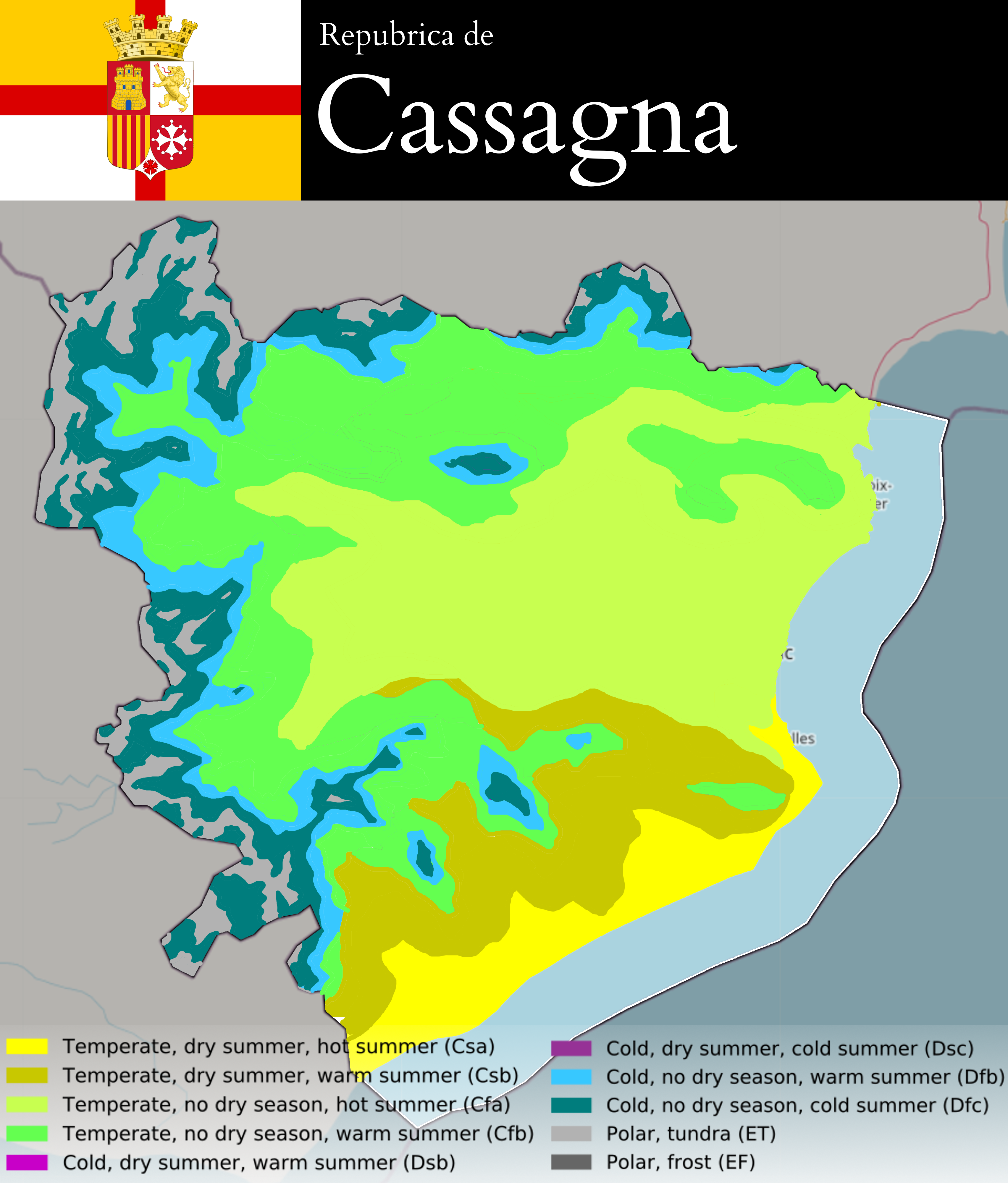
Climate
Cassany sits entirely between 44 and 47 degrees north, along the north-western shores of the Mesembric Sea - bang on the transition zone between oceanic and Mediterranean climates IRL. This is north of most of the RW European Mediterranean (close to Atlantic coast of mid-southwest France, e.g. Bordeaux, La Rochelle; Liguria, and the northern Adriatic, e.g. the Po Valley) however the Mesembric empties into an ocean south of the North Atlantic. The Catens range creates a rain shadow from westerly rainfall, however, they also push rainfall and humidity up (including storms) from the Mesembric back towards the east. This creates significant rainfall during summer months in the Baìsa valley in particular.
In the south, where the mountains drop more rapidly and the convection system creating storms in the east is lesser, the climate is dryer in the summer. Cassany also straddles the boundary for hot-summer climates, but the mid-north east has an overall slightly cooler climate, receiving somewhat more easterly rather than southerly influence. This is why the north/central-east borders Cfb (oceanic/maritime) and Cfa (warm temperate/humid subtropical), whereas the south borders Csb (warm-summer Mediterranean) and Csa (hot-summer Mediterranean); it is also why the north/central regions are more "green" and temperate than the south. Agriculture between the Metessan regions and the rest of Cassany differs too.
Overall, Cassany - especially the eastern basin - enjoys mild winters, fairly consistent rainfall, warm summers, and long growing seasons for the agriculture being utilised there. The southern coast has a dry season in the summer, while the eastern one and inland largely do not.
 | Human geography |
|---|---|
| A brief description of the territory demographics, economic development, land occupation, infrastructure and mapping style |
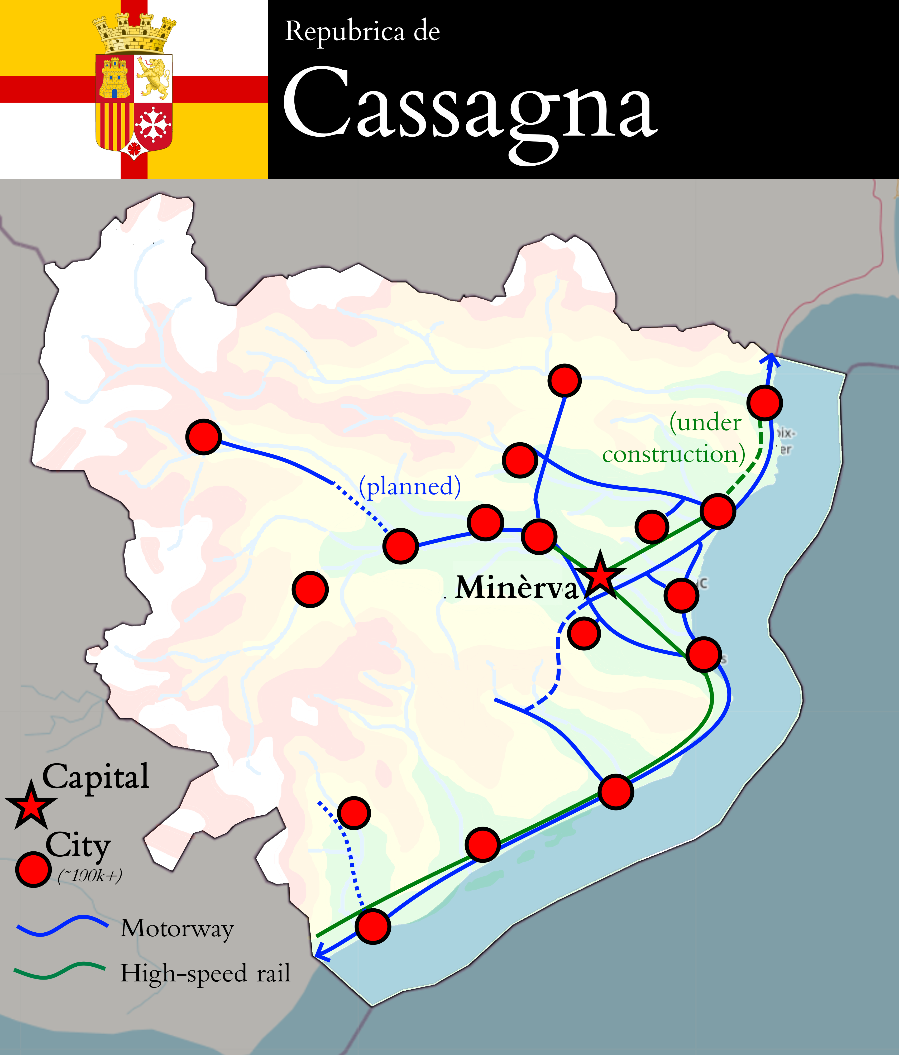
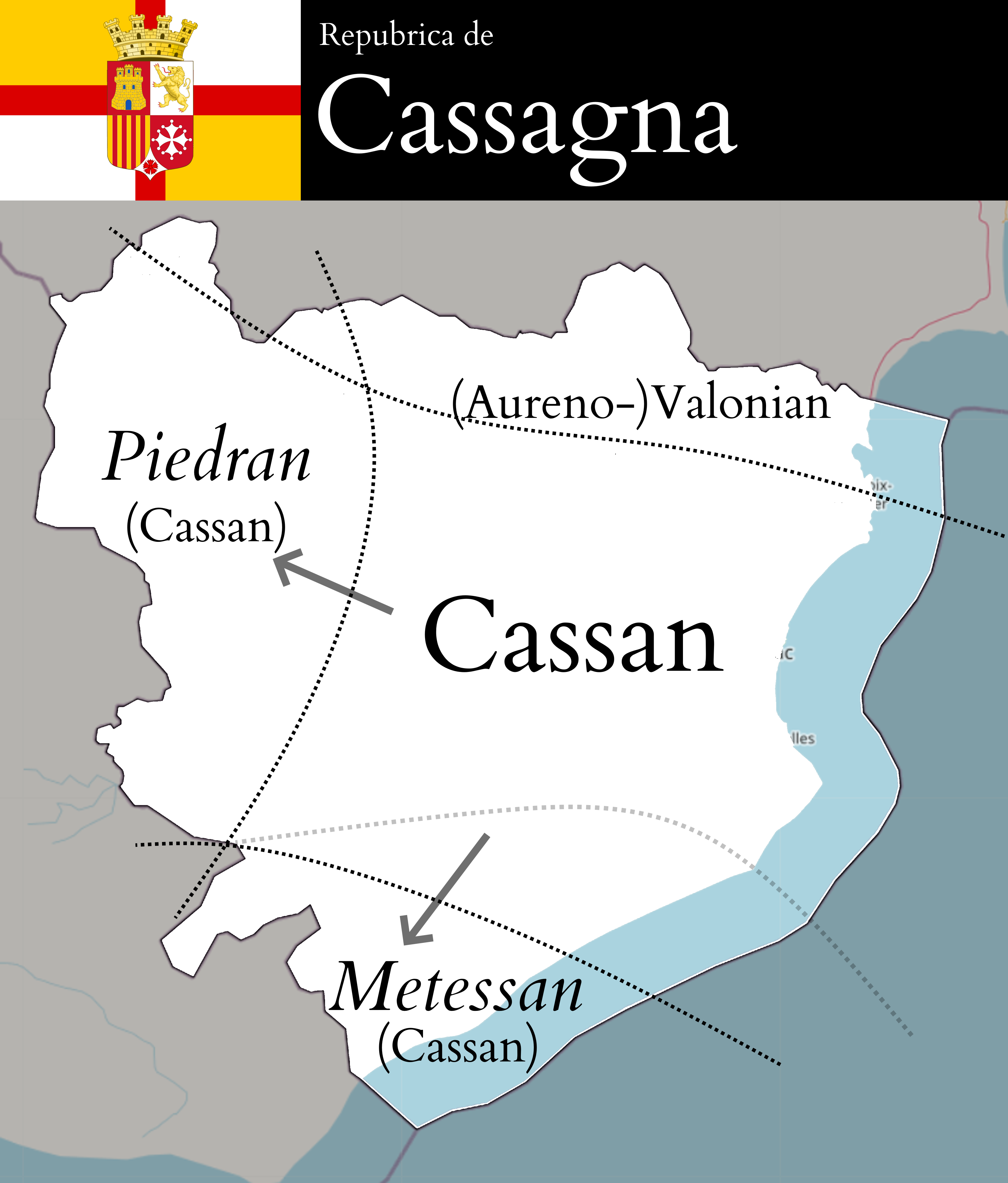
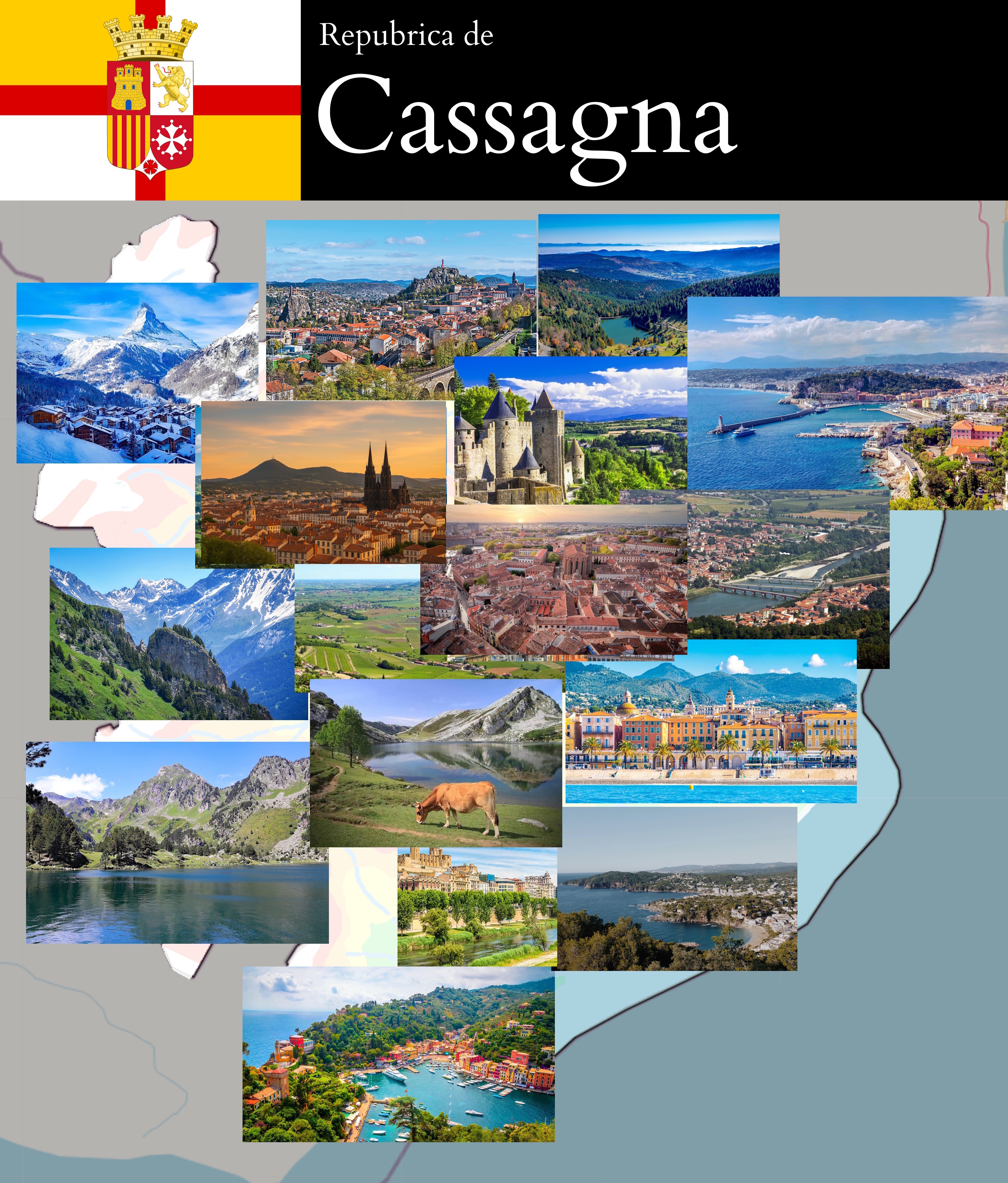
Cassany is a liberal democracy and a confederal republic, with very significant historic and continuing influence from Valonne and Plevia, as well as Castellán and the Mesembric states to a lesser extent. The name "Cassany" (Cassagne in Valonian, Cassagna in Cassan) derives from the emperor Cassian(us), who conquered the region in 220BCE. It remained an [!OGF Roman Empire] outpost due to its advantageous location and productive ports, which initially spoke a variant of Vulgar Latin akin to that of the southwest of Valonne. However its language diverged from both Latin and the Vulgar !Latin spoken in Valonne for over a thousand years, due to its distance from the metropoles in Nemans, [Not!Rome / UL08i∈⊾ƨ], and physical separation and containment of the Cassans across the Baìsa Valley. This intensified with the migration of peoples from the western coast of modern-day Plevia across the sea to the Cassan cities, in particular around the eastern outflow of the Baìsa; their principal port in this era was Sulevia, likely named after the Celtic/pre-!Latin god referred to by the [!OGF Roman Empire] provincial inscriptions within then-"Cassania". Cassania was split into two provinces during the late Roman period, probably following a rebellion, which saw the power of its ports (and the central administrations and legions within Maissana and Sulevia) wane.
UL08a has an area of 44,768.02km2 including its waters, and near ~40,000km2 in land area. This makes Cassany comparable to Denmark/Holland/Switzerland/Belgium, around the same area as Northwestern Italy, and a little larger than Catalonia or Provence. Cassany has a primarily service-based industrialised/advanced economy comparable to Northern Italy, but with the Metessan south somewhat less advanced. It has a strong, but not dominant financial sector, a focus on SMEs, and a heavy industrial sector based around automotives and shipbuilding, all of which are being undermined by foreign competition and internal corruption (which grows stronger the further from the capital one goes). The currency would the Cassan lìbra (₶).
The mapping style for most of (lowland) Cassany would lean on influence from the  Rhone Valley, Catalonia, Northwestern Italy, and the Po Valley - lots of vineyards, canals, cities, and infrastructure, while the uplands would feature more alpine-style villages, signs of tourism (ski villages) and hydroelectric power (dams, reservoirs). The south would probably be somewhat less urbanised. I think the country altogether would have around 9 million people, give or take.
The highly federal, mercantile, and subsidiarity-based nature of Cassan politics and government also leads to disparities between provinces' intracity networks; one province may have strong bus and tram networks serving its cities, while another may be functionally reliant on private transport, while one province's industries may directly outcompete another's into dereliction. There is also a capable, if sometimes a little outdated (since to some extent Cassany probably has a stagnant, if advanced, economy), intercity rail network, which centres on passing along the Baìsa Valley or tracing the north-east->south-east->south-west coast. Cassany suffers from some degree of pollution - the same basin that serves as a cradle for a mild, wet, arable valley and dense population centre also funnels and concentrates ozone and nitrogen oxides, as well as causing increased agricultural waste.
The Baìsa Valley would be heavily cultivated, and by far the densest part of the country - there would be notable population centres/a belt along the southern (Metessan) and eastern coasts, and to a lesser extent amongst the hills in the north-central region, and some significant populations along the foothills between the Baìsa Valley and the Catens. The higher uplands in the west, meanwhile, would be more sparsely populated, with winding roads, protected natural zones, sporadic villages/towns along the lakes and rivers & industries increasingly centred around tourism. This more closely resembles Valle d'Aosta and the Pyrenees. Maissana would be the capital (as depicted - with some heavy influence from Toulouse, as well as to a lesser extent Milan, Lyon, and Turin), however sometimes challenged by the main port city and second city Santa Arsàçia (which would be more inspired by Nice, Marseille, and Genoa) to its east - Maissana would probably have a metropolitan area of a million or two, and Santa Arsàçia maybe another million. Other cities include Lusciandra (the third city), Çerusa, Atrinio, Zenexa, Borgomâ, Montegianco, Tiçian, and Verrucòso (these comprising the next tier of cities), as well as the towns/small cities of Laetöio, Arnasca, Pòrto Veturio, Aigla d'Arogna, Gaio, Belfòrte, Ottavio, Meverna, Monzemo/Montezemo, Giasènta, Lumarso, Aulìvola, Lerze, Mieuja, Màllare, Leivia, Priabrùna, Ciusavéia, Armosa, Ciävai, Zoagiana, Oê, and Segusia.
 | History & culture |
|---|---|
| A brief description of the intended culture and language |
History (post-!Roman)
During the mediæval era, the former provinces of Cassania Superior and Inferior had fragmented into a wide range of city-states and kingdoms, some of which were more akin to the Vulgar Latin substrates in Valonne, while others were more heavily influenced by the Plevian incomers. Through a series of mercenary wars, skirmishes, and royal marriages, most of Cassany (including many of the Plevian colonies) had become de facto possessions of Valonne by around the 12th century, while some of the eastern cities had become de facto possessions or vassals of Plevia's kingdoms.
This mixed control, but unrecognised autonomy, was interrupted by the Rising in 1339, which overwhelmed what little authority that the largest duchy within Valonian Cassany - the Ducato de Aosci - had remaining. The new aristocratic government of Maissana ordered the dismantling of Valonian influence; Latin was substituted for the vernacular, independent courts of law and parliaments were established, and the Church of Cassany was no longer subjected to Valonian authority. By leaning deliberately towards Plevia, Cassany safeguarded its independence and many of its aristocrats and leaders deliberately played upon the "national" identity shared between the states; this began to influence a cultural and economic flourishing of the aristocratic republics. Valonne’s invasion in 1348 to subdue many of the cities resulted in an initial overwhelming of most of the former Valonian cities, leaving the Cassan republican class exiled east, and the temporary subjugation of Cassany; Valonne would prove either unable or unwilling to sustain the standing army (likely amid the !Black Death?), and with Plevian help as well as the erosion of Valonian control through sporadic unrest, Cassany slowly reasserted its independence. During this time, Cassany probably starts to consciously identify as one entity under the name of the Cassan Republic (Repubrica Cassañaña) and also develops relations with Castellán - who are likely eager to keep Cassany separate from a thus slightly weakened Valonne but not let it be entirely reliant on Plevia - and the rest of the Mesembric, and thus becomes mutually dependent on positive, mercantile relations, alliances, and trade.
Maissana (now clearly the centre of culture and commerce within Cassany) and Santa Arsàçia (a city to its east having succeeded the role of the formerly-ruined Sulevia) began to exert increasing control over the peripheries, who feared sacking by other Mesembric powers or Valonne, in exchange for negotiated taxation and participation in the Casa d'Assemblea (parliament). Cities still remained largely self-governing under this compromise and raised their own militias, while the state became responsible for long-term naval defence, with the Cassan Republic commissioning the first ships of the Marina Reiala - the focus of the modern Cassan armed forces is its navy (centred at the port of Santa Arsàçia).
This evolves into the Renasciontia (as part of the wider Mesembric Renaissance), taking inspiration from Florence and the northern/central Italian merchant city aristocratic republics - this linguistic flourishing also is heavily influenced by Plevia. In the early modern era (~1600), a series of costly failed maritime endeavours and defeats leads Cassany to spend much of the early modern era under the de jure control of Plevia by the consent of the aristocratic class (who slowly get eroded away under this arrangement); a war between Plevia and Valonne results in its ceding to Valonne in the mid-1700s. Cassany thus remains under Valonian, not Plevian, control for around a century (with sporadic unrest and a cultural revival effort that Valonne directly attempted to suppress), until the Revoluçion do Giaçinto (Hyacinthe Revolution) in 1830-1, which saw the independence of Cassany as a unified, if still very federal, state; revolutions in Aurence fail in the same period. A following revolution in the border province of Aurence in 1878 results in its own independence, however repeated incursions, skirmishes, and later diplomatic issues with Valonne result in Cassany being required to give high levels of deference to the province (and especially its vestigial Valonian influence, language, and education) even compared to the other areas of the country.
The Baìsa valley industrialised rapidly due to its location and access to coal and fresh water in the 19th century, causing huge rural-urban migration and centralising the confederation's units around their unit cities - most of the major cities are somewhere along the Baìsa valley, or the coast that the Baìsa's basin reaches. In the 20th century, Cassany fractured politically, with communists, trade unionist, social democrats, liberals, Christian democrats, regionalists, and nationalist conservatives all carving out bases that grew and fell at various points, such that the 21st century Cassany is a bit of a messy compromise patchwork with a social-market economy (with large informal sectors), interventionist governments generally, and a relatively generous welfare state.
Summary & culture
Cassany would be primarily !Ligurian in culture, but also inspired by the rest of northern Italy, the Provence area of Occitania/southern France as well as Corsica and Catalonia. Aurence in the far-north would be somewhat more Valonian, with !Arpitan as its spoken language and Valonian as its mapped/written language (usually). Many, if not possibly a majority of Cassans, speak Valonian too.
Its key strain would be civic/municipal mercantile republicanism - it would be a developed country, with mostly adequate transport links (but with notable gaps and/or in-work constructions, as shown on the diagram), as well as regional divides (typically getting better the closer to Maissana and/or a few richer provinces that one gets), and a very high rate of urbanisation in the east, whose inhabitants would enjoy very strong municipal powers. There would probably be quite a significant number of provinces - probably based around the capital, Santa Arsàçia, one or two semi-major other metros, and about five to ten other regional cities - whose identities would mostly (but not all) trace back to the ~1300s.
Cassany has an Academia Cassaniaña as a direct Académie Francaise analogue, set up in the Enlightenment era amid the rise of liberal nationalism - this has caused the dialectal continuum of Cassan as between !Ligurian in most of the country, !Emilio-Romagnol in the southwest, and !Piedmontese in the north-west. I expect it would be historically minded to stay out of wars if possible, but would not reach Switzerland-levels of neutrality, particularly if roped in with Valonne and/or any Mesembric nations. Direct democracy and participatory democracy would remain heavy, to the point that Cassany probably gets stereotyped as voting on any old nonsense, while political dynasties would also be quite common with absolutely no corruption or nepotism whatsoever. Religion remains a major part of Cassan life, with the Catholic church a central institution within Cassany despite its state secularism.
Its cuisine is characteristically Mediterranean and pulls from its ready access to seafood (especially along the coasts and Metessa), however the further west/north one goes, the more Alpine it becomes.
Cassan architecture depends on the region - many of the cities were renewed as part of the Neoclassical movement following the union with Aurence and constitutional liberal reforms under a somewhat renewed central government in the 1880s-1930s, which created significant monuments and some degree of (delusion of) grandeur in the centres, especially Maissana.
Poverty is more common in the far-south, which is less industrialised, more corrupt, and honestly a bit abandoned by what federal government there is (naturally, municipal autonomy lends itself to a reluctance towards redistribution...), suffering from a brain drain; this means that its mapping would show less prosperity along the Metessan coasts, especially in the mid-sized cities/towns along its coast.
Cassany is probably a member nation within ASUN.
 | Past mapping |
|---|---|
| To support your request provide links to areas of OGF mapping which showcase your mapping skill. Mapping relevant to the requested theme & geography is especially useful. | |
| The {{coord}}, {{node}}, {{relation}} or {{scalehelper}} templates can optionally be used to link to the OGF map - they result in nicely formatted links. Or you can paste in a URL. |
I have spent a week or so working on what I hope to emulate in Cassany in the form of the town and surroundings of  Serranac, in addition to the experience I have in my Almetia application from January 2025. Hope this helps!
| Username & date |
|---|---|
| Sign and date the application by typing four tildes (~~~~) without spaces or "nowiki" tags. |
Alsatian (talk) 19:17, 5 July 2026 (UTC)
 | Discussion |
|---|---|
| Discussion for clarification & decision |
- This overall is a really good application, a lot of the things click. Just need a confirmation, if I am understanding this right: the language (Cassan) is derived from Vulgar Latin, inspired by Ligurian, and other Gallo-Italic dialects? Is it a conlang or directly derived from those languages? Either way it makes sense to be present in this territory, given what you've described. I wonder if Monegasque could work as an alternative to pure Ligurian, due to the influence from Valony, given that Monegasque is essentialy a variety of Ligurian. The geography works, climate as well, probably identical to the Po River Valley and Marche regions. Theprovided mapping example is great as well.
From a technical point of view, I will understand this application as a downsize, since this territory is smaller than Almetia. That being said, I'd suggest you to focus on this territory in the long term and avoi switching territories in the near future. ── Bixelkoven (talk) (West Uletha Admin) 15:43, 7 July 2026 (UTC)
Great to hear! Cassan in a strict sense would be Ligurian (w/Academia Cassaniaña standardising the premier/prestige dialect). Of course, since Ligurian itself (especially beyond the Genoese dialect) is a touch unstandardised, that standardisation would be partly conlanged, and that would probably involve bringing it overall a touch closer to Valonian (including with influence from Monégasque!). In a looser sense, it would also "comprise" a variety of Gallo-Italic languages (including Piedmontese, Emilio-Romagnol), but the recognition of these as separate would be messy and usually less present in "formally" written (and thus mapped) territory than it would in spoken vernacular outside of provinces that specifically push for a difference, as well as less standardised in their forms.
More than understandable. I think I got off to a false start with Almetia, and very much am intending to focus on Cassany. Glad that the rest of the proposal seems to fit together as well as it did in my head! — Alsatian (talk) 18:31, 7 July 2026 (UTC)
- After some discussions with my coordinating partner, that should work, given that the inclusion of other Gallo-Italic languages affects Cassan itself. It is not ideal to have those languages (such as Emilian, Piedmontese, etc.) be present on their own in small pockets within the territory alongside the Ligurian-inspired main language, it's a too small area for so many individual languages. If the former is what you've described/what we've understood, then that absolutely works. I am not sure whether Arpitan could work in the north, standard Valonian (or whatever Valonian variant is used on the other side of the border) is a better choice in our opinion, unless it's Arpitan that is spoken in that part of Valony, which I cannot confirm myself. Lastly, we hope the language experimentation will not be a burden to you when mapping in this territory, i.e. overwhelm you too much. I'd ask for one final confirmation that we've agreed to terms, after which I can proceed with the application finalization. ── Bixelkoven (talk) (West Uletha Admin) 21:17, 10 July 2026 (UTC)
Yeah, I can happily confirm this is what I meant. The Academia Cassaniaña kinda serves as a helpful justification not to have to adapt every region to its own vernacular (and to stop it becoming a pain/timesink!), so the standard Genoese Ligurian-inspired language would be the type used universally in mapping itself. A similar deal would exist for Arpitan/standard Valonian, but if it's not confirmed what dialect is immediately north of UL08a, then I'd be more than okay with just dropping Arpitan outright and using standard Valonian for mapping. I'm more than happy to agree. Alsatian (talk) 00:00, 11 July 2026 (UTC)
 |
Territory application approved |
|---|---|
| Approved. ── Bixelkoven (talk) (West Uletha Admin) 12:19, 12 July 2026 (UTC) | |
| You will be informed when the territory is ready for you. |