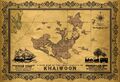
 | File:Antarephia Climate.png Overview of Antarephia: potential climates (local variations are possible). Main mountain ranges are depicted in black as cli
(1,197 × 559 (195 KB)) - 20:18, 9 June 2022 |
=== Local Highways ===
Local Highways use four-digit numbers, from 1000 to 9999.
4 KB (441 words) - 07:47, 27 April 2024
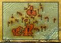
 | File:Antarephia Geo Sector.png Overview of Antarephia: potential "Bioregions"(local variations and details may be considered). Main mountain ranges are depicte
(1,126 × 559 (112 KB)) - 20:22, 9 June 2022 |
 | File:Fsa frankfortroads.png ...int between Carapebus and Macaé (Rio de Janeiro state). In OGF, it is some local road close to Frankfort city, Elway state (FSA).
(582 × 415 (558 KB)) - 13:58, 30 July 2022 |
| name = Naskadan
...0% of the population of 1.1 million. Other population centers mainly serve local industries such as forestry, mining, hydropower, and gas extraction. Touris
2 KB (318 words) - 11:01, 8 March 2024
...e emails are being bounced with <code>5.7.1 [HM08] Message rejected due to local policy</code>. Thanks/[[User:Wangi|wangi]] ([[User talk:Wangi|talk]]) 08:36
894 bytes (127 words) - 08:37, 30 April 2024
...usually the largest town. Counties are further divided into four types of local government areas (LGA).
District councils are the local government areas (LGA) that surround a town or towns, usually for more popu
5 KB (655 words) - 03:02, 6 November 2023
...es and lists due to the country's conlang not being made (and therefore no name having been chosen).''
| name = UL13c
5 KB (803 words) - 10:09, 24 September 2023
!Adapts to local language?
|name
3 KB (487 words) - 17:57, 31 August 2023
...ia, and their ability to execute the necessary maneuvers properly, and the local conditions and lead-up. [[User:MKH1020|MKH1020]] ([[User talk:MKH1020|talk]
1 KB (159 words) - 18:04, 4 June 2023
{{Territory application id and name}}
Villages and cities.Various highways and local roads.
2 KB (224 words) - 14:04, 6 June 2022
* Add more detail to the cemetery <s>and give it a name</s>
* [https://opengeofiction.net/history#map=16/-36.9517/156.2494&layers=B Local area changesets]
1 KB (163 words) - 14:28, 26 August 2023
| name = Duchy of Searavenag
...bility over the region gradually waned, giving more power to assemblies of local free men. Foundation of "parliament" in 1024, but built upon earlier courts
5 KB (659 words) - 18:45, 29 October 2022
...ce traffic demand on the motorways, with alternatives such as national and local roads running parallel to the motorways. Additionally and obviously, it is
...ast 50% funded from the national government but works are conducted by the local authorities of the provinces it runs in.
14 KB (2,061 words) - 09:28, 12 May 2024
{{Territory application id and name}}
I map a lot more on my local client, but I haven't figured out how to migrate this to a web server.
2 KB (266 words) - 13:21, 20 September 2023
.../burgundy canton. Perhaps taken a coat of arms of someone important to the local history (King Eustace?), or it could show an Archantan Christic Identity wh
2 KB (255 words) - 20:39, 26 August 2021
{{Territory application id and name}}
...ay was constructed in late 1990s but it stays abandoned due to protests of local farmers, boatmen and truck company lobby in the legislature.
7 KB (1,059 words) - 18:18, 16 October 2023