Collab:Bai Empire/Port Dunghoi
If you have any questions you can reach out to User:Zhenkang (coordinator). Please keep in mind that the information below may change as things update accordingly in the future. Thank you. |
Port Dunghoi∈⊾ is a major city of the Bai Empire on the east coast bordering Kanglapo. This page is mainly to coordinate collaboration for the city with a list of available projects.
Participtation
Much of the city remains in construction. The project remains open for collaboration. All experienced users, even those unfamiliar with Chinese, are welcome to message me or ask on the discussion page if they want to participate. You can help detail a neighbourhood, or even map other major infrastructure like railway stations or universities.
General layout
The original intention of Port Dunghoi is that it would be Bai's "Hong Kong", a Cantonese-speaking financial hub. However, there already exists a "Hong Kong" in Cinasia's Tan Kong (and Cinasia itself is already a Hong Kong expanded to a national scale). Much of the mapping has been laid out by Hilsonbergman, who is also the owner of Cinasia. Hence, this city should be more than just another Hong Kong of OGF.
As the name suggests (meaning "East Sea Port"), the city will be a major port on the east coast of the Empire, and a frontier city to Kanglapo at its south. While the city speaks Cantonese (and a portion speaks Katayan), simplified Baizi will still be used for place and street names. The city will be mainly inspired by Shenzhen (i.e. plenty of manufacturing zones as a technology and research hub) with other elements from other cities in the Guangdong–Hong Kong–Macau Greater Bay Area (including Macau and Hong Kong).
The size of Port Dunghoi Municipality proper is 1243.36 km², similar in size to Shenzhen and Hong Kong.
Districts and Neighbourhoods
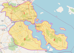
The city of 8 million people has three main planning districts:
- Chiujeung (昭璋)∈⊾ will be the main commercial area of the city, with urban sprawl spreading beyond the municipality.
- The island (which is the official centre of Port Dunghoi)∈⊾ will be more industrial with a harbour facing the Ardentic Ocean, while the urbanised area close to the mainland will be mainly commercial and/or higher-income residential.
- Gingwang (景宏)∈⊾ will be mainly residential, with industrial developments nearer to the border as part of joint special economic zones between Bai and Kanglapo. This area still needs more mapping.
Transport
Railways and rapid transit
There might not be a spanning subway system throughout the city (if there is, likely one serving the mainland side for Chiujeung and Gingwang). I plan for local railway services to function as the rapid transit system instead, supplemented by trams. The island itself could be served by a light rail system. The rail system is up for further development.
International connections
Dunghoi does not have a commercial airport due to its proximity to Dongyue International Airport in Xiongjing, which is only 100km away. To make up for this, work is needed for rail and road connections between Xiongjing and Port Dunghoi.
Nevertheless, Dunghoi will have a major harbour facing the Ardentic Ocean on the east coast of the island. This project is something I will leave for more experienced mappers to submit plans and proposals.
