File:Deodeca Plan.png
Size of this preview: 600 × 600 pixels. Other resolution: 2,000 × 2,000 pixels.
Original file (2,000 × 2,000 pixels, file size: 615 KB, MIME type: image/png)
Summary
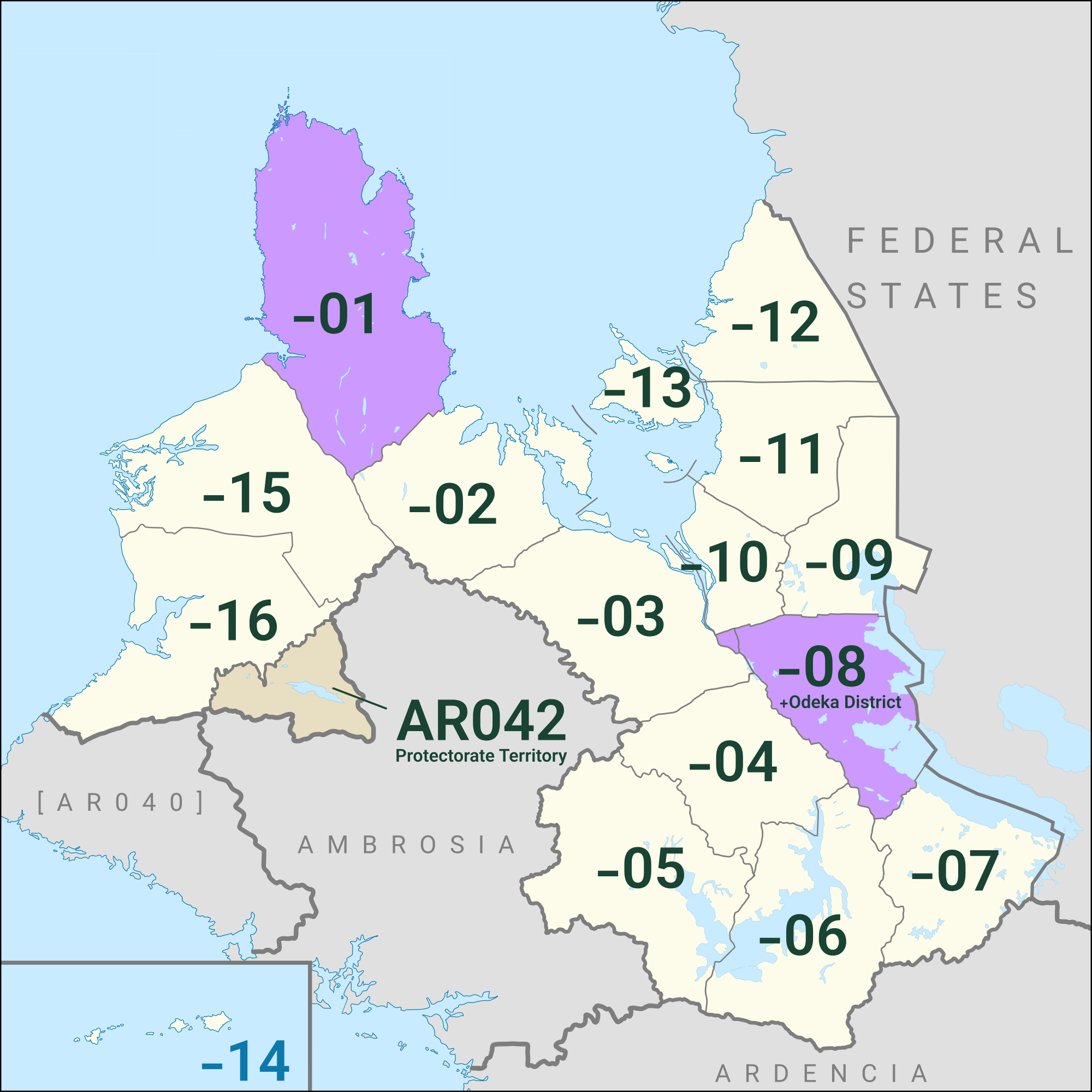
Preliminary plan for Deodeca. Bold brown lines represent ridges of hills/mountains; some potential major rivers shown in blue. States shown in purple, with potential major city sites (orange stars) and potential national capital location (yellow star). Possible transportation corridors in orange. FSA/Deodeca border is still under discussion and is not final; borders with other nations are not anticipated to change. States labeled in purple will open in Phase II; dark gray in Phase III; and light gray in Phase IV.
Licensing
| This map is a derivative of the OpenGeofiction base map, which is licensed under the Creative Commons Attribution-NonCommercial-ShareAlike License and is released under the same license. |
File history
Click on a date/time to view the file as it appeared at that time.
| Date/Time | Thumbnail | Dimensions | User | Comment | |
|---|---|---|---|---|---|
| current | 18:42, 22 December 2023 | | 2,000 × 2,000 (615 KB) | Varnel maiser (talk | contribs) | The current provinces and protectorates of Deodeca. Purple provinces -01 (Ingerish Asperia) and -8 (Agawaskway) are closed collaborative projects. * Updated plan to reflect the addition of -15, -16, and AR042 to the project. |
| 15:11, 24 March 2022 | Error creating thumbnail: File missing | 1,361 × 1,379 (1.33 MB) | TheMayor (talk | contribs) | Updated Deodeca Plan as of 24 Mar 2022 to reflect new English-language mapping focus. Comparable lines of latitude are estimated. | |
| 20:27, 8 November 2021 | Error creating thumbnail: File missing | 744 × 800 (516 KB) | TheMayor (talk | contribs) | Updated Deodeca plan, as of 8 Nov 2021. Phase II states (08-13) are now available for adoption, with State 10 planned as a collaborative. Gray states (01-04) are Phase III states, and black states (05-07) are Phase IV states. Hill/mountain ranges shown in brown; major rivers shown in blue. National capital shown in yellow; likely/potential city sites in each state shown as an orange star but subject to change. | |
| 21:29, 4 November 2021 | Error creating thumbnail: File missing | 1,360 × 1,356 (1.36 MB) | TheMayor (talk | contribs) | Preliminary plan for Deodeca. Bold brown lines represent ridges of hills/mountains; some potential major rivers shown in blue. States shown in purple, with potential major city sites (orange stars) and potential national capital location (yellow star). Possible transportation corridors in orange. FSA/Deodeca border is still under discussion and is not final; borders with other nations are not anticipated to change. States labeled in purple will open in Phase II; dark gray in Phase III; and li... |
You cannot overwrite this file.
File usage
The following page uses this file: