example with space: {{OGF user|andy lahm}}
link recent edits: {{OGF user|andy lahm|history}}
272 bytes (30 words) - 02:18, 7 April 2024
...]|}}''<br /><br /><small>{{#if:{{{translator|}}}|Translation provided by {{OGF user|{{{translator}}}}} on {{{date}}}.|}} To help translate documentation i
1 KB (125 words) - 00:14, 28 December 2022
<includeonly>[https://github.com/wangi/OGF-terrain-tools/blob/master/{{{1}}} <sup>(git)</sup>{{{1}}}]</includeonly><no
* '''<nowiki>{{ogf-git|bin/tileReplicate.sh}}</nowiki>''' ==> {{ogf-git|bin/tileReplicate.sh}}
277 bytes (30 words) - 01:01, 27 March 2022
...round:#dddddd; color:#b73737; text-align:center; height: 35px;" | Official OGF Documentation
...rted|Getting started]] • [[OGF:Site policies|Site Policies]] • [[OGF:Terms of Use|Terms of Use]]
694 bytes (83 words) - 15:58, 6 November 2021
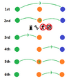 | File:OGF Air Freedoms.png Graphical reference of OGF's six air freedoms, from the perspective of the orange nation. Gas pump and
(494 × 575 (12 KB)) - 21:49, 19 August 2022 |
-
2 members (0 subcategories, 0 files) - 14:31, 18 September 2021
...p is a derivative of the [[OGF:About|OpenGeofiction]] base map, which is [[OGF:Copyrights|licensed]] under the<br />[[wikipedia:Creative Commons|Creative
|}<includeonly>[[Category:Images derived from the OGF map|{{PAGENAME}}]]</includeonly><noinclude>[[Category:Copyright templates]]
785 bytes (102 words) - 17:00, 29 June 2022
-
757 bytes (96 words) - 20:47, 18 October 2021
A list of pages with technical documentation of the OGF platform.
[[Category:Official OGF Documentation]]
14 members (0 subcategories, 0 files) - 13:48, 3 March 2022
-
23 members (3 subcategories, 0 files) - 12:11, 28 August 2021
|[https://turbo.ogf.rent-a-planet.com/?q=LyoKVGhpcyBoYcSGYmVlbiBnxI1lcmF0ZWQgYnkgdGhlIG92xJJwxI
|[https://turbo.ogf.rent-a-planet.com/?Q=%2F*%0AThe%20original%20search%20was%3A%0A%E2%80%9Cbra
3 KB (487 words) - 17:57, 31 August 2023
[[Category:Official OGF Documentation]]
8 members (0 subcategories, 0 files) - 04:25, 28 December 2022
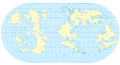 | File:Ogf base world map.svg Blank map of the OGF world landmasses, with latitude and longitude lines every 15 degrees over t
{{Cc-ogf-map}}
(1,020 × 549 (1.67 MB)) - 22:59, 24 April 2024 |
-
11 members (0 subcategories, 0 files) - 16:18, 13 September 2021
...mages directly to this category! Instead, update the license to be {{tl|Cc-ogf-map}}. If the map is only a portion of the file, add the map's license temp
292 members (0 subcategories, 292 files) - 01:35, 3 August 2022
...the version we have running on the site has changes to update naming (OSM>OGF) and change the available mapping layer. But we'd like to go a step further
# Use an OGF specific map layers list
1 KB (214 words) - 16:45, 30 November 2022
...mes, changing host countries etc etc etc... Months later, everybody forget about it. Will we do it again? -- [[User:BMSOUZA|BMSOUZA]] ([[User talk:BMSOUZA
2 KB (322 words) - 13:36, 3 December 2022
:Good question. The ultimate goal is to have a “current” map of the OGF world, but some mappers choose to update their parts of the map in a more h
1,023 bytes (157 words) - 02:35, 20 November 2022
| 6 October 910. Aged about 50
8 KB (935 words) - 10:04, 15 October 2023
{{OGF user|Alessa}},
{{OGF user|Bixelkoven}},
2 KB (273 words) - 18:38, 19 January 2024
...round:#dddddd; color:#b73737; text-align:center; height: 35px;" | Official OGF Documentation
...rted|Getting started]] • [[OGF:Site policies|Site Policies]] • [[OGF:Terms of Use|Terms of Use]]
694 bytes (83 words) - 15:58, 6 November 2021
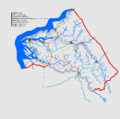 | File:DE-15 Application Update20231224.png Based on the works of {{OGF user|Arlo}} and {{OGF user|Lithium-Ion}}. Re-drawn by sudo91. Original map is taken from OpenGeof
{{cc-ogf-map}}
(1,085 × 1,080 (28 KB)) - 13:22, 25 December 2023 |
 | File:Pax Nova logo.png ...ork by {{OGF user|Pawl}}, based on the design of {{OGF user|isleño}} and {{OGF user|Luciano}}.
(1,200 × 985 (62 KB)) - 21:47, 29 August 2022 |
...mail to info@opengeofiction.net. For technical inquiries, please see the [[OGF:Contact|contact page]].
! OGF user page
1 KB (174 words) - 23:25, 20 November 2023
...i>[link to location in OGF]</nowiki> more realistic. Can someone help me? -OGF User 1
...ivers]] tutorial. If you need more help, please send me a message in OGF. -OGF User 2
645 bytes (108 words) - 16:10, 6 September 2021
<includeonly>[https://github.com/wangi/OGF-terrain-tools/blob/master/{{{1}}} <sup>(git)</sup>{{{1}}}]</includeonly><no
* '''<nowiki>{{ogf-git|bin/tileReplicate.sh}}</nowiki>''' ==> {{ogf-git|bin/tileReplicate.sh}}
277 bytes (30 words) - 01:01, 27 March 2022
 | File:Marker-airport2a.png Originally created by {{OGF user|mstr}} for the OGF project.
(25 × 25 (1 KB)) - 09:26, 25 November 2021 |
A list of pages with technical documentation of the OGF platform.
[[Category:Official OGF Documentation]]
14 members (0 subcategories, 0 files) - 13:48, 3 March 2022
 | File:WM Shield revised.svg ...user|TheMayor}} that itself is derived from an outline of the state on the OGF map.
{{Cc-ogf-map}}
(240 × 240 (4 KB)) - 04:53, 30 January 2024 |
 | File:Emb-green.png Originally created by {{OGF user|isleño}} for the OGF project.
(50 × 50 (4 KB)) - 21:19, 5 September 2021 |
 | File:Emb-yellow.png Originally created by {{OGF user|isleño}} for the OGF project.
(50 × 50 (5 KB)) - 21:19, 5 September 2021 |
 | File:Emb-red.png Originally created by {{OGF user|isleño}} for the OGF project.
(50 × 50 (4 KB)) - 03:15, 6 September 2021 |
 | File:Basse Ambroisie.jpg Originally created by {{OGF user|Newflanders}}
{{cc-ogf-flag}}
(465 × 274 (22 KB)) - 12:55, 26 March 2022 |


