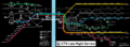
 | File:LCTAowlservice.png Owl (overnight) service map of the Lake City Transit Authority's rail lines. Own work. Airport icon in public domain at https://en.m.wikip
(5,700 × 2,100 (1.49 MB)) - 00:20, 8 April 2022 |
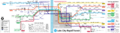 | File:LCTAmap.png System map of the Lake City Transit Authority's 'J' train system. Own work.
(3,780 × 1,050 (1.34 MB)) - 21:54, 8 May 2023 |
...ion of the Federal States. The state is situated between Lake Amanecer and Lake Sauganash, surrounded by the state of [[Illuvia]] to the north; [[Iroquesia
...g either portaging between the lakes or taking a more circuitous route via Lake Betaouais, which was particularly dangerous during the winter months. Minno
22 KB (2,994 words) - 03:37, 14 February 2024
| official_name = City of Miller
| settlement_type = City
23 KB (3,482 words) - 00:06, 16 December 2023
...ugh these would have likely operated and had rolling stock more similar to transit (metro, streetcar, interurban, etc.) rather than what is generally consider
...est corridors emerged over these eastern mountains: a Huntington-Massodeya City corridor; a New Carnaby-AR120-36 corridor; and a Fellshire-AR120-56 corrido
58 KB (6,565 words) - 05:39, 24 January 2023
| name = Lake City
| official_name = City of Lake City
173 KB (23,895 words) - 03:36, 7 June 2023
...e Delenshire Islands, passing through the St. Renecene Strait, sacking the city and attempting to approach Stanton from the sea from the southeast.
* 1610 Founding the city of [[Stanton]]
17 KB (2,578 words) - 00:01, 30 August 2021
| capital = [[Fayaan City]]
...ate trading company led by the Asselmans and Goedhuys families founded the city of Noordkaap in 1489 (according to oral traditions) or 1492 (according to i
62 KB (8,795 words) - 05:09, 2 December 2023