Bromley City
| Bromley City | |||
|---|---|---|---|
| Capital City | |||
| Country | Bromley | ||
| • Region | Erbale | ||
| • County | City | ||
| |||
| Population | |||
| • Census (2024) | 2,593,021 | ||
| • Density | tbd/km2 | ||
| Demonym | Cityman | ||
| Government | |||
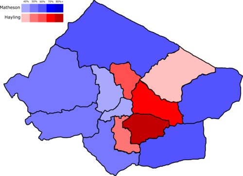
| • Mayor of Bromley City | Michael Hayling (Labour) | ||
| • Leader of the Borough Assembly | Worsel Bragg (Labour) | ||
| Area | |||
| • Total | tbd km2 | ||
| • Urban | tbd km2 | ||
| Elevation | tbd m (tbd ft) | ||
| Metro | yes | ||
| Tram | no | ||
| Website | city.gov.br | ||
Bromley City is the capital, and largest city of Bromley, with a population of around 2.2 million. It stands on the River Princer, which runs east to west through the country. Bromley City was once very rural, and was home to many native Bromlavian tribes. The capital was established in 1732 by Ingerish settlers who had expanded their control of the land area, and was named New Folkstyne. Some buildings from this colonial period still remain in the city. During the 20th Century, the city boundary was expanded to include towns such as Dumfry and Bosthorpe.
Bromley City is Bromley's seat of government. While farms remain in the outer parts of Bromley City, the city has developed to become a hub for the tertiary sector, with a significant number of offices. Bromley City exerts a strong influence on the banking and corporation industry, thanks to its gold exports from the Bromlavian mountains. City Port, located on the coastal parts of Bromley City, is also a strong trading hub which provides a substantial amount of Bromley's income.
Bromley City is home to many tourist attractions, such as Harting Cathedral, the National Assembly, the Museum of Bromley and the Ciconi Gallery. Bromley City's leadership is working to attract tourists to Bromley by investing in further attractions.
Bromley City has faced many struggles over the past few decades. Terror attacks by Barkenfrier separatists have been carried out several times, and protests have also caused chaos.
History
Colonial Times
Bromley City was first established as New Folkstyne, after Folkstyne in Ingrea, in 1732, as part of the Folkstyne Declaration. Ingerish settlers had travelled from Portslade, where they had first landed. Homes and plantations were set up by the Ingerish, who displaced the native Bromlavian tribes. Bromlavian tribes were rounded up and forced to complete slave labour on the plantations, in an attempt to make the colony of Bromlaeg a major trading hub for primary industry. The flat lands by the River Princer proved to be prosperous farming lands. New Folkstyne became an attractive place for Ingerish migrants to set up farms, and migrants flooded over to Bromlaeg in the late 18th century.
Inequality between black native Bromlavians and Ingerish migrants was incredibly wide, and this only worsened when the population of Ingerish migrants began to outnumber that of natives.
Most of the colony's population was centered in New Folkstyne until the migration of white Bromlavians to the west of the colony. Discoveries of gold in the west allowed the capital to flourish as a result of sea trade, and the city's port enabled the city to quickly urbanise in the late 19th century.
During the early 20th century, instability grew as a result of class divisions amongst wealthy plantation owners, and those migrant families whose farms had been eclipsed by the more successful wealthier migrants. As a result, the idea of revolution grew amongst New Folkstyne's poorer residents. This tension grew into a coup, led by Kalmish-Ingerish migrant, Friedrich Farkas, who established the idea of Bromlavian communism. Assets were redistributed to poorer Bromlavians and the inequality gap in the colony was reduced. However, Farkas' regime was overthrown in a bloody coup made by Ingerish troops in 1920.
In 1931, Sanmarquino troops launched an invasion in New Folkstyne, but the colony's troops were halted by a counterinvasion of Sanmarquino territories. The trade of La Trinidad back to San Marcos gave the colony a significant influx of money, which was used to develop New Folkstyne's urban areas. As a result, the capital grew very quickly and Bromley-Cambria became a leading hub for agriculture and industry.
Prime Minister Lord Roland Harting attempted to negotiate a transition of power of the colony from Ingrea to mainland Bromley, but Ingerish troops attempted a coup of his government. War was declared and New Folkstyne's urban population suffered as a result. However, a victory for Bromley-Cambria paved the way for the end of colonial rule, independence of the colony and the establishment of a renamed capital, Bromley City.
Post-Colonial times
Thanks to Bromley's independence, precious resources which would have been sent to Ingrea stayed in Bromley, allowing the country to trade them with other countries for high prices. These trades allowed Bromley City to prosper, and many lower-skilled workers began to work in the newly established docks in modern-day Faston. Social housing was built around the docks, and wealthy Bromlavians began to create new middle-class suburbs and estates, which they managed as landlords. Highly-skilled migrants were attracted to this prosperity in Bromley City, and flooded into the capital once again. Metro networks were built, and two metro lines spanning from Folson to Faston, and Rayersham to Harnsey were established in the 1950s.
This influx of migrants created tensions amongst established Ingerish-Bromlavians and new migrants, and as a result, sentiments of anti-immigration grew. This led to the election of the Bromley Defence Party in the 60s, which stopped immigration into the city. Many of the city's residents fled to rural areas in the country as a result of the merciless regime of Arthur John Adams, which led to the genocide of many black Bromlavians in the city. After the fall of the Adams regime, black Bromlavians began to migrate back to the city, settling in places in the south of the city such as Shadwick, Rayersham and Jarrow.
The city's boundary was extended to the towns of Hoxton, Lessington, Dumfry, Oakheart and Bosthorpe in order to cater for the rapidly rising population and new suburbs were established in these areas, allowing the density of the central parts of the city to reduce and become less overcrowded. Farms were built over and the manufacturing/trade industry grew.
The growth of ports in other countries and the lack of remaining gold supplies led to Bromley City falling behind in terms of international trade and manufacturing. As a result, the docks in Faston and Tuebrook were closed in 1980, leading many of its residents to become unemployed. Deprivation grew in these parts, and regeneration was kickstarted in these areas, with a significant number of social homes being built. Today, the areas are still being regenerated and gentrified, with the construction of the Peninsula metro Line.
Modern Bromley City
As a result of cheaper rents in the capital, large corporations were created in the city by wealthy migrants, particularly in the banking industry. The tertiary industry grew rapidly while the primary and secondary industries suffered.
Administration
Most of the services in Bromley City are administered by the Mayor of Bromley City, currently Trudy Matheson of the Bromlavian Conservatives.
List of Mayors of Bromley City
| Mayors of Bromley City | ||||||||
|---|---|---|---|---|---|---|---|---|
| Portrait | Mayor | Term of office | Party | |||||
| Error creating thumbnail: | Bonny Debden (1940-) |
5 May 1997 – 7 May 2001 |
Bromlavian Conservatives | |||||
| File:Ed Rendell.jpg | Joe Branson (1952-) |
7 May 2001 – 4 May 2009 |
Bromlavian Labour Party | |||||
| File:2017-11-16 Michael Müller (Wiki Loves Parliaments 2017 in Berlin) by Sandro Halank.jpg | Kenneth Wanning (1960-) |
4 May 2009 – 5 May 2017 |
Bromlavian Labour Party | |||||
| File:Edmund G Brown Jr.jpg | James Henley (1949-) |
5 May 2017 – 3 May 2021 |
Bromlavian Conservatives | |||||
| File:Water Security 2015 Conference (23468652260) (cropped).jpg | Michael Hayling (1955-) |
3 May 2021 – 5 May 2025 |
Bromlavian Labour Party | |||||
| File:Wendy Larner 2016.jpg | Trudy Matheson (1965-) |
5 May 2025 – present |
Bromlavian Conservatives | |||||

Borough Assembly
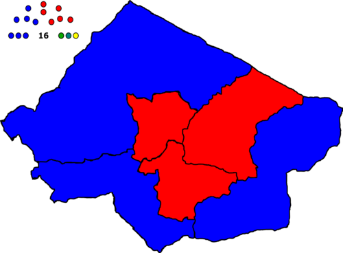
Bromley City is seperated into 13 boroughs. Boroughs are grouped together to form larger constituencies, which elect members to the Borough Assembly.
Members of the Borough Assembly
| Constituency | Makeup | Member | Party | Notes |
|---|---|---|---|---|
| City North | Boroughs of Bosthorpe and Cannock & Holbeck | Matthew Smith | Bromlavian Conservatives
|
|
| City Central | Boroughs of Dunton, Harting and Rayersham & Shadwick | Davet Solvek | Bromlavian Labour Party
|
|
| Dumfry and Gramley | Boroughs of Dumfry and Gramley | Corvin Frollard-Welsh | Bromlavian Conservatives
|
Leader of City Conservatives Group |
| Edderton and Plaistow | Boroughs of Edderton and Plaistow | Worsel Bragg | Bromlavian Labour Party
|
Leader of the Borough Assembly |
| Faston and Manham | Boroughs of Faston and Manham | Maureen Brook | Bromlavian Labour Party
|
|
| Hoxton and Oakheart | Boroughs of Hoxton and Oakheart | Adrianna Croft | Bromlavian Conservatives
|
|
| Citywide | Dylan Peters | Bromlavian Conservatives
|
||
| Citywide | Orla West | Bromlavian Conservatives
|
||
| Citywide | Tony Morrows | Bromlavian Conservatives
|
||
| Citywide | Wesley Porkroft | Bromlavian Conservatives
|
||
| Citywide | Anna Kendrick | Bromlavian Labour Party
|
||
| Citywide | Leonard Targetik | Bromlavian Labour Party
|
||
| Citywide | Eshan Demir | Bromlavian Labour Party
|
||
| Citywide | Oscar Carmichael-Johnson | Green Earth
|
||
| Citywide | Gordek Tagetetig | Unity Alliance
|
||
| Citywide | Thomas Crosby | For Bromley
|

Local Government
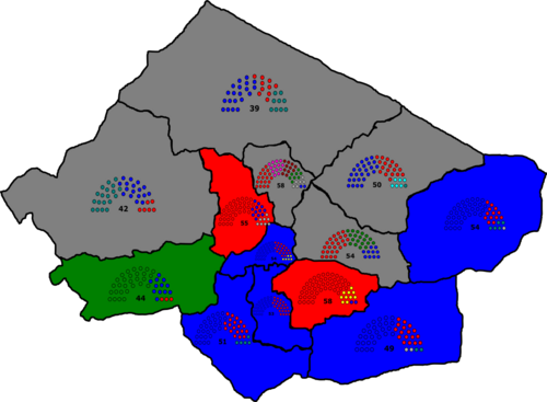
Each borough is adminstered by its borough council, which manages roads, waste collection, local services and housing. Councils appoint a leader, who is usually from the majority ruling party. Councils in Bromley City are required by law to function as a majority so that a council budget can be passed, meaning that, if no party achieves a majority, a coalition must be formed to provide support to the administration.
City Boroughs
| Borough | Description | Administration Party | Council Leader | Ward Map |
|---|---|---|---|---|
| Bosthorpe | Bromlavian Conservatives For Bromley
|
Cllr Jim Smith
|
? | |
| Cannock & Holbeck | Cannock & Holbeck is a mostly rural borough. The borough has high income levels and low crime rates. | For Bromley Bromlavian Conservatives
|
Cllr William Harold
|
? |
| Dunton | Bromlavian Conservatives
|
Cllr Judy Owens-Tatgiket
|
? | |
| Dumfry | Dumfry is an up and coming borough, with many residents moving out to live by the river and its luscious green spaces. Investment is being directed towards the borough in order to fuel its knowledge economy. | Green Earth
|
Cllr Fenton Kennedy-Callus
|
? |
| Edderton | Bromlavian Conservatives For Bromley
|
Cllr John Hills
|
? | |
| Faston | Faston Local Socialists Left Progression Green Earth
|
Cllr Alma Sevget
|
? | |
| Gramley | Bromlavian Conservatives
|
Cllr Thomas Willis
|
? | |
| Harting | Harting is considered to be the heart of Bromley City. Named after the respected Prime Minister, Lord Roland Harting, the borough is home to some of the oldest buildings in the city. The borough thrives within the tourism industry, and is home to many large corporations. | Bromlavian Conservatives
|
Cllr Granville Rotherham
|
? |
| Hoxton | Inequality is prevalent in Hoxton. In the east of the borough, large detached houses are found, and land use is more rural. In the west of the borough, many terraces and council blocks are found. The borough has a notable Demirhan community, who tend to be more conservative. | Bromlavian Conservatives
|
Cllr Deniz Arap Kartal
|
? |
| Manham | Manham is considered to be the western central part of Bromley City. The borough consists of a mixture of historic architecture, large corporations and dense urban neighbourhoods. Manham has a rich military history. The area is incredibly well connected by public transport to the rest of the country. | Bromlavian Labour Party
|
Cllr Louise Cartell
|
? |
| Oakheart | Bromlavian Conservatives
|
Cllr Terence Andrews
|
? | |
| Plaistow | Bromlavian Labour Party Green Earth
|
Cllr Taket Bordogikiget
|
? | |
| Rayersham and Shadwick | Rayersham and Shadwick is a diverse and working class borough. Many of the city's black Bromlavian population reside in the borough and make up around 54% of the area's population. Rayersham and Shadwick is well connected to the rest of the city. The borough has the highest crime rate in the city. | Bromlavian Labour Party
|
Cllr George Clack
|
? |

| Council | 2001 | 2005 | 2009 | 2013 | 2017 | 2021 | 2025 |
|---|---|---|---|---|---|---|---|
| Bosthorpe | CON | CON | CON | CON | CON | CON | NOC CON-FBR coalition |
| Cannock and Holbeck | CON | CON | CON | NOC LAB-IND coalition |
CON | CON | NOC FBR-CON coalition |
| Dunton | CON | LAB | LAB | LAB | CON | LAB | CON |
| Dumfry | CON | CON | CON | LAB | GRE | GRE | GRE |
| Edderton | NOC LAB minority |
LAB | LAB | LAB | LAB | NOC LAB minority |
NOC CON-FBR coalition |
| Faston | LAB | LAB | LAB | LAB | LAB | NOC FLS-LPR-GRE coalition |
NOC FLS-LPR-GRE coalition |
| Gramley | CON | LAB | LAB | LAB | CON | LAB | CON |
| Harting | CON | CON | CON | LAB | LAB | NOC LAB-LIB coalition |
CON |
| Hoxton | CON | CON | CON | LAB | CON | CON | CON |
| Manham | CON | CON | CON | LAB | CON | CON | LAB |
| Oakheart | CON | CON | CON | LAB | CON | CON | CON |
| Plaistow | LAB | LAB | LAB | LAB | LAB | NOC LAB-GRE coalition |
NOC LAB-GRE coalition |
| Rayersham & Shadwick | LAB | LAB | LAB | LAB | LAB | LAB | LAB |
Geography
| Bromley City | ||||||||||||||||||||||||||||||||||||||||||||||||||||||||||||
|---|---|---|---|---|---|---|---|---|---|---|---|---|---|---|---|---|---|---|---|---|---|---|---|---|---|---|---|---|---|---|---|---|---|---|---|---|---|---|---|---|---|---|---|---|---|---|---|---|---|---|---|---|---|---|---|---|---|---|---|---|
| Climate chart | ||||||||||||||||||||||||||||||||||||||||||||||||||||||||||||
| ||||||||||||||||||||||||||||||||||||||||||||||||||||||||||||
| ||||||||||||||||||||||||||||||||||||||||||||||||||||||||||||
Hydrography
Bromley City sits on the River Princer, which flows from the Asperic Ocean to Akerù, Barkenfry. As a result of the central parts of the capital being a terminus for trading ships, the river has become significantly polluted. After these docks closed, attempts were made to bring the river back to a healthy state, but ecosystems have been considerably damaged past the point of regeneration. Many tributaries flow from the Princer, such as the Grove, Hatches and Lantern rivers. Nowadays, these tributaries are lined with apartments aimed towards the middle-classes.
The south of the city is home to a few reservoirs, such as Fletton Lakes, which provide a source for power generation and water storage. Locals also take up sailing on the lakes.
Topography
Bromley's altitude differs between the northern and southern parts of the city. Land south of the Princer is somewhat hilly, but becomes flat around the inner city. Northern land, however, becomes mountaineous along the city borders. Residents live among the hills around Dumfry, Cannock & Holbeck and Bosthorpe, which serve as a beautiful backdrop against the city. Landslips are common around these areas, and regularly block roads and train lines.
Crime
Crime rates in Bromley City vary widely. Crime is a lot more prevalent in the inner parts of the city, notably in the boroughs of Dunton, Rayersham & Shadwick and Faston. Critics have claimed that discrimination towards Bromlavians of the Ostafariuan-Je and Imani communities has led to crime figures for these groups being disproportionately higher than those from the white Bromlavian community.
The Buttercup Estate in Dunton is known for being one of the most dangerous locations for violent crime in the city. Gang culture is prevalent on many social housing estates, and there are regular instances of vulnerable individuals being recruited into these gangs. Feelings of deprivation by residents on these estates have led to large riots, particularly during periods of political and economic unrest in the country.
Demography
Bromley City is considered to be diverse in terms of ethnicity. Although the majority of the city's population is of white ethnicity, pockets of communities can be found around the city. For example, the City Borough of Rayersham is home to many Ostafariuan-Je families, the City Borough of Faston is home to the largest population of Imani families, and the City Borough of Hoxton has a small Demirhan community. Holmic communities can be found in the north of the city too.
Census population figures
| Year of census | Population | Change |
|---|---|---|
| 1804 | 603,421 | |
| 1814 | 721,120 | +19.5% |
| 1824 | 1,142,689 | +58.4% |
| 1834 | 1,358,125 | +18.9% |
| 1844 | 702,273 | -48.3% |
| 1854 | 985,321 | +40.3% |
| 1864 | 1,085,193 | +10.1% |
| 1874 | 1,288,012 | +18.7% |
| 1884 | 1,404,095 | +9.0% |
| 1894 | 1,003,512 | -28.5% |
| 1904 | 1,032,600 | +2.9% |
| 1914 | 1,093,741 | +5.9% |
| 1924 | 1,321,614 | +20.8% |
| 1934 | 1,501,396 | +13.6% |
| 1944 | 1,874,412 | +24.8% |
| 1954 | 1,719,344 | -8.3% |
| 1964 | 1,710,425 | -0.5% |
| 1974 | 1,600,391 | -6.4% |
| 1984 | 1,648,129 | +3.0% |
| 1994 | 1,999,380 | +21.3% |
| 2004 | 2,108,345 | +5.4% |
| 2014 | 2,230,942 | +5.8% |
| 2024 | 2,593,021 | +16.2% |
Economy
Transport
Rail
Bromley City is home to three terminus stations - City Harting, City Riverside and City Jarrow.
City Harting is located in the Harting area of the city, and acquired its name as a homage to the late Prime Minister, Lord Roland Harting. It was first opened in 1909 as a small railway station, but saw a grand expansion in 1920. City Harting accommodates trains from the south and less dense west of Bromley. It is a hub for commuters in the denser parts of southern Bromley City.
City Riverside is noted as Bromley's busiest station thanks to its links to the city's main airport, its connections to underground links and its direct connection to Barkenfry and international links to Layr. Riverside is the newest of Bromley City's terminus stations, opening in 1960.
City Jarrow is the oldest of Bromley City's terminus stations, opening in 1804 as a connection to City Port, where Bromley imported most of its goods under colonial rule. Ingerish migrants also travelled to Jarrow in order to settle in the city. The station was expanded in 1933.
Underground
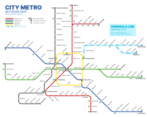
Bromley City's underground services are administered by the Mayor of Bromley City and the privately owned City Metro organisation. The city is served by 5 underground lines, which reach out to outer parts of the city via the centre. The city's underground system was first established in 1959 as part of an expansion project, and in order to cater for the influx of Bromlavians relocating from the inner lands. In 1983, the service was privatised and outsourced to the foreign InterLink TNC. InterLink went into administration in 2005, and the underground system was nationalised, until it was sold to Metro Corp, and their City Metro branch in 2008.
Metro Corp have drawn up plans for the future of City Metro:
| Route | Plans | Estimated year of completion |
|---|---|---|
| City Metro Line 6 | Extension project including the construction of 8 stops - Sonning Quay, New Tuebrook, Cambridge Park, South Tuebrook, Piker Road, Tuebrook, Bradley Lane and Bullfield | 2028 |
| City Metro Line 7 | New line added to the network - branching from Cannock Hill/Holbeck to Locksdon, via Cornish Mead | 2030 |
| City Metro Line 3 | Extension of Tamlyn Line past Tenterden | 2030 |
City Metro remains a popular way to travel across the city, but has been criticised for its inconsistent services.

| Line | Name | Service | Opened |
|---|---|---|---|
| City Metro Line 1 | Northern Line | Beebury ↔ Retford | 1959 |
| Beebury ↔ Bosthorpe | |||
| City Metro Line 2 | Hanover Line | Cannock Hill ↔ Hoxton Town | 1959 |
| City Metro Line 3 | Tamlyn Line | Dumfry Hills ↔ Tenterden | 1980 |
| Dumfry Hills ↔ Oakheart Central | |||
| City Metro Line 4 | River Line | Fosterchick ↔ Bromley City Airport | 1992 |
| City Metro Line 5 | Circle Line | Lowell Docks ↔ Lowell Docks | 1999 |
| City Metro Line 6 | Peninsula Line | Peninsula Water ↔ Shepperton | 2024 |
| Peninsula Water ↔ Docker Bridge |
Buses
Aviation
Roads
Education
Culture
Bromley City is well known for its markets, both indoor and outdoor. Tourists flock to Hanover and Malta Court markets in the centre of the city. Markets sell a range of Bromlavian-made products, mostly by small family owned businesses. The informal economy is also prevalent around the city's markets, and generates a large amount of untaxed income for businesses. Markets in Bromley City also host a range of self-employed entertainers during the weekends and the summer holidays.
Bromley City also has a thriving hospitality economy, both during the day and night. Cafe culture is prevalent, and there are many bars across the city. Bromley City was once ranked as one of the top nightlife destinations in the world.
