Forum:Territory application/AN142b - Криційська Федерація (Kritsian Federation)
| Territory ID and proposed name | |
|---|---|
| The Territory ID (from OpenGeofiction:Territories, e.g. AR123a) and proposed name of the country |
AN142b - Криційська Федерація (Kritsian Federation) (Collaborative)
| Physical geography | |
|---|---|
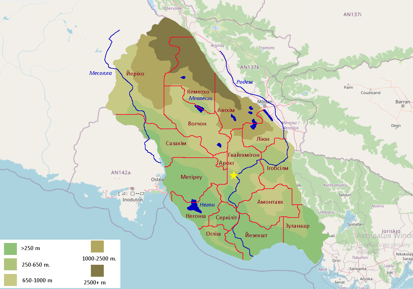
| An overview of climate, topography and landscape of the country. With the exception of Beginner territories, you should always create a sketch map to illustrate & explain your plans. You can add a link to this (hosted on imgBB, Postimages or similar, but not imgur.com) |
Mountains of Central Antarephian chain passing through north border, making several mounty zones souther. These zones surround small plain with lake at the centre. East mountains have many lakes in it.
There are two main rivers: Rodezh (1200~ km) and Mesolla (700~ km) and lake Negon (500 km²).
Climate is familiar to Crimean/South Argentina, warm moderate. 26-34 C⁰ at summer, 4- -4 at winter. Wind current from north makes seacoast bit warmer.
 | Human geography |
|---|---|
| A brief description of the territory demographics, economic development, land occupation, infrastructure and mapping style |
Kritsia is divided on 16 governorships.
The population is around 8 million (On 170.000 square kilometers). Most of population concetrated along Rodezh and at coast line.
Infrastructure - mixed. But mainly its american suburb style and post-soviet (but with nuances). Big cityes almost absent (max is 300.000 people). Scyscrathers and high residential buildings rarely appearing. The priority is given to private building, villages, small towns.
There will be no macromapping without micromapping.
| History & culture | |
|---|---|
| A brief description of the intended culture and language |
Following repression in the then kingdom located in current Geklinia-Dragolesia, and in search of a better life, the Krinolians (Ukrainians) and Borishians (Belarusians) began sailing to the continent of Antarephia in the early 18th century. In 1761, at a general council, they decided to create the state of Kritsia. Due to the expansion of their settlements, local tribes (Arghosh and others) began to notice and attack them. The most aggressive were enslaved, while the rest were gradually accepted into society. In 1811 there was an uprising and war against the totalitarian Emperor Jiishik Morolsky, in 1955 there were also several uprisings, and since then there have been almost no military conflicts on the territory of the country.
The culture is East Slavic, predominantly Ukrainian. The language is also Ukrainian. The main religion is pagan. The society is liberal and conservative. Kritsia is an aristocratic republic with neo-feudalism. The economy is market-based.
| Past mapping | |
|---|---|
| To support your request provide links to areas of OGF mapping which showcase your mapping skill. Mapping relevant to the requested theme & geography is especially useful. | |
| The {{coord}}, {{node}}, {{relation}} or {{scalehelper}} templates can optionally be used to link to the OGF map - they result in nicely formatted links. Or you can paste in a URL. |
Gevaighmigon (Made within month)
Milont (3 days)
Detailed rural mapping and nature mapping (OSM)
| Username & date | |
|---|---|
| Sign and date the application by typing four tildes (~~~~) without spaces or "nowiki" tags. |
Кріц (talk) 15:27, 25 February 2026 (UTC)
| Territory application closed | |
|---|---|
| User permanently blocked. /wangi (talk) 20:15, 21 March 2026 (UTC) | |
| The following resources can be useful in building up mapping experience: Help:Portal, Help:Making realistic countries, Help:Making realistic cities and also OpenGeofiction:Site policies |