Forum:Territory application/AR022 - Avanta
- Please fill in the information below to make a territory request.
| Territory ID and proposed name | |
|---|---|
| The Territory ID (from OpenGeofiction:Territories, e.g. AR123a) and proposed name of the country |
| Physical geography | |
|---|---|
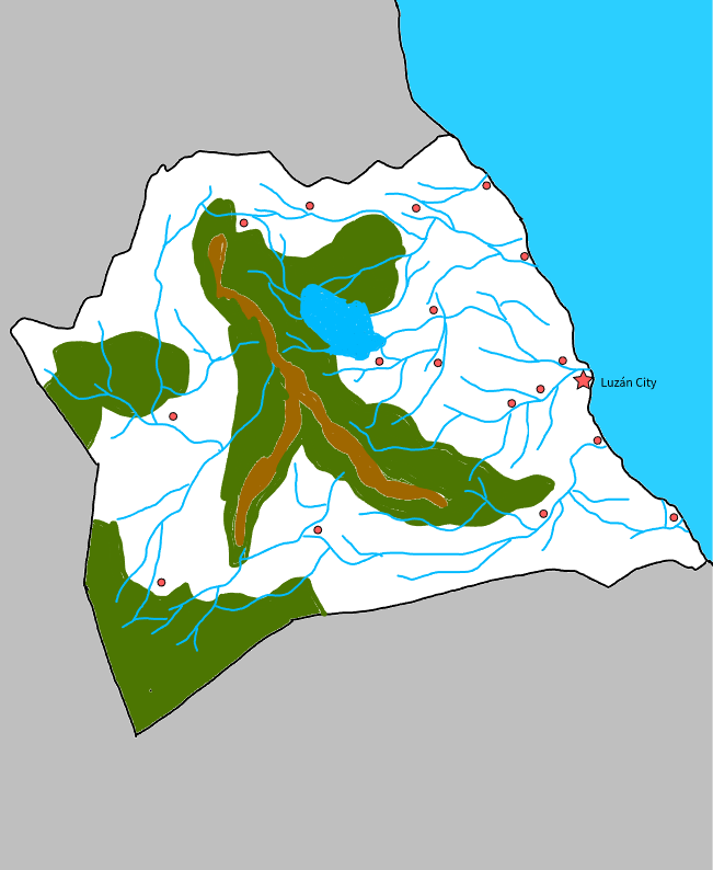
| An overview of climate, topography and landscape of the country. With the exception of Beginner territories, you should always create a sketch map to illustrate & explain your plans. You can add a link to this (hosted on imgBB, Postimages or similar, but not imgur.com) |
Avanta is located in a tropical zone, with coastlines to the north and east, and a diverse geography that combines mountains, valleys, and coastlines.
Climate:
- Tropical humid: Most of the country has a tropical humid climate, with average temperatures ranging from 22°C to 28°C.
- Seasons: There are two main seasons: a dry season (December to April) and a rainy season (May to November).
Topography:
- Fatima Mountain Range: The Fatima mountain range runs through the country from center to south, creating a mountainous landscape with peaks that exceed 2,000 meters in height.
- Valleys: The valleys of Brumaria are fertile and inhabited by most of the population.
- Coastline: Avanta's coastline is rocky and mountainous, with some white sand beaches and crystal-clear waters.
Landscape:
- Mountains: Avanta's mountains are covered in tropical and subtropical forests, with a wide variety of flora and fauna.
- Rivers: Rivers are numerous and flowing, and are used for hydroelectric power generation and crop irrigation.
- Waterfalls: There are several impressive waterfalls in the country, popular among tourists.
https://i.postimg.cc/mZQbNY5b/Vitaleda_Map.png
 | Human geography |
|---|---|
| A brief description of the territory demographics, economic development, land occupation, infrastructure and mapping style |
Human Geography of Avanta
Demographics
- Population: The population of Avanta is approximately 25 million inhabitants, with the most populated city being Luzán, the capital, located on the eastern coast of the country.
- Distribution: The majority of the population is concentrated in the coastal areas and in the center, in the Brumaria valley, where the main cities and economic centers are located.
- Ethnic composition: The population of Avanta is mostly mestizo due to its colonial origin (Spain), with a minority of Italian and French origin.
Economic Development
- Economy: Avanta's economy is based on mining, tourism, agriculture, and manufacturing.
- Natural resources: The country is rich in natural resources such as copper, gold, silver, and zinc.
- Infrastructure: Avanta's infrastructure includes roads, ports, and airports that facilitate the transportation of goods and people.
Land Occupation
- Land use: Avanta's land is primarily used for agriculture, livestock, and mining.
- Protected areas: There are several protected areas in the country, including national parks and natural reserves near the mountain range. In the southwest, archaeological zones protected areas can be found crossing the mountain range.
Infrastructure
- Roads: Avanta's road network is extensive and connects the main cities and economic centers.
- Ports: Avanta's ports are important centers of trade and maritime transportation.
- Airports: The country has 4 international airports that connect Avanta with the rest of the world.
Mapping style: Latin American.
| History & culture | |
|---|---|
| A brief description of the intended culture and language |
History of Avanta
Avanta is a nation with a rich history that dates back to pre-Hispanic times. The region was inhabited by various indigenous tribes, including the Axanies, who developed a sophisticated and complex culture. With the arrival of the Spanish, Avanta was colonized and became a province of the empire. After independence, Avanta became a republic and has maintained its cultural identity and rich history.
Culture of Avanta
The culture of Avanta is a mix of influences. The nation is known for its rich tradition, music, and dance.
- Art: Art in Avanta is an expression of the nation's cultural identity. Avantan artists are known for their works that reflect the country's history and culture.
- Music and Dance: Music and dance are fundamental to Avantan culture. The nation has a rich tradition of folk music and traditional dance.
- Gastronomy: Avantan cuisine is a mix of indigenous and Spanish influences. Typical dishes include corn, beans, chilies, and meat.
Traditions and Customs
- Festivals and Celebrations: Avantan celebrates several festivals throughout the year, including Independence Day and the Harvest Festival.
- Rituals: Avantans practice rituals to honor their ancestors and ensure the country's prosperity.
- Crafts: Craftsmanship is an important part of Avantan culture. Avantan artisans are known for their skills in wood carving, ceramics, and weaving.
National Identity
The national identity of Avanta is based on its rich history and culture. Vitaledans are proud of their heritage and work to preserve and promote it. The nation is known for its hospitality and love of life.
Axani Influence
The Axani culture has had a significant impact on Avanta's national identity. The Axanies were an indigenous tribe that inhabited the region, and their legacy can be seen in the nation's architecture, art, and traditions. Avantans are aware of their Axani heritage and work to preserve and promote it.
| Past mapping | |
|---|---|
| To support your request provide links to areas of OGF mapping which showcase your mapping skill. Mapping relevant to the requested theme & geography is especially useful. | |
| The {{coord}}, {{node}}, {{relation}} or {{scalehelper}} templates can optionally be used to link to the OGF map - they result in nicely formatted links. Or you can paste in a URL. |
1.3494, 43.828
| Username & date | |
|---|---|
| Sign and date the application by typing four tildes (~~~~) without spaces or "nowiki" tags. |
Fer Jiménez (talk) 22:44, 25 November 2025 (UTC)
 | Discussion |
|---|---|
| Discussion for clarification & decision |
I'm sorry, there is an error in the name of the request, it is the AR022 territory without the "b". My apologies in advance. Fer Jiménez (talk) 23:13, 25 November 2025 (UTC)
- Hi, I have the following major concerns:
- Lack of recent mapping activity & engagement - no edits at all for well over a year. You also made a previous request for the same territory, which was closed due to a lack of a follow up response.
- Past urban mapping is excessive grids with little else.
- Past rural mapping is minimal, with concerns on hydrology too.
- Your past territory is in an area which would likely work for the characteristics defined in this application. You could apply for it and tidy up your previous mapping, rather than leaving that as problem for someone else to deal with?
- I think you should resume mapping, and would recommend the blue Tierra Nueva∈⊾ƨ for this. You can build up a showcase to support either another application for this territory, or a reapplication for TA110∈⊾ƨ. Regardless, I would encourage you to contact the TA admin to discuss how you can help with maintenance of your past mapping. Thanks/wangi (talk) 11:36, 26 November 2025 (UTC)
Hello, Im sorry. My mapping has been inconsistent; I stopped this year because I lost territory TA110 due to inactivity, but it's an activity I enjoy. With my new laptop, I promise to be consistent.
If this request is closed, I understand. Regards. Fer Jiménez (talk) 17:27, 26 November 2025 (UTC)
- Ok, I'll close it out. The main thing to do is resume mapping. Thanks/wangi (talk) 10:52, 27 November 2025 (UTC)
| Territory application closed | |
|---|---|
| Closing on user request /wangi (talk) 10:52, 27 November 2025 (UTC) | |
| The following resources can be useful in building up mapping experience: Help:Portal, Help:Making realistic countries, Help:Making realistic cities and also OpenGeofiction:Site policies |