Forum:Territory application/UL11f - Hemstein
- Please fill in the information below to make a territory request.
| Territory ID and proposed name | |
|---|---|
| The Territory ID (from OpenGeofiction:Territories, e.g. AR123a) and proposed name of the country |
UL11f - Häömsjteinbeed (Hemstein)
| Physical geography | |
|---|---|
| An overview of climate, topography and landscape of the country. With the exception of Beginner territories, you should always create a sketch map to illustrate & explain your plans. You can add a link to this (hosted on imgBB, Postimages or similar, but not imgur.com) |
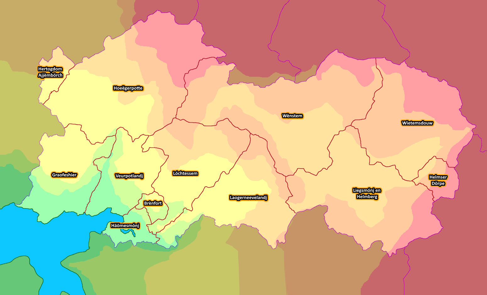
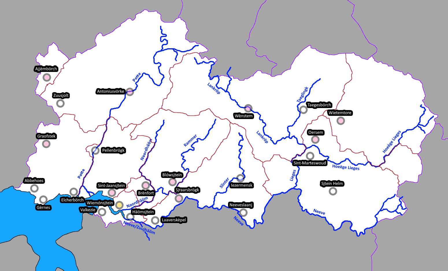
The south and east of Hemstein consist of the drainage basin of two rivers which share an estuary; the North Hem, and the South Hem or Neeve; the coastal areas of the nation are by far the centers of population and historic interest. The western flank of the country is a mostly flat plateau, through which a third river (River Potte) flows. The country's southern border is almost entirely made up by the river Neeve; in the east and north-east, by ranges of tall hills. Only in the far east will there be proper mountains. Overall, Hemstein has a temperate climate, similar to that of Germany; becoming colder deeper inland.
- Rough estimate heightmap and cantons
- Rough map of rivers and cities (some names have changed since this map was made)
- Rough population density map, including the "invisible line"
 | Human geography |
|---|---|
| A brief description of the territory demographics, economic development, land occupation, infrastructure and mapping style |
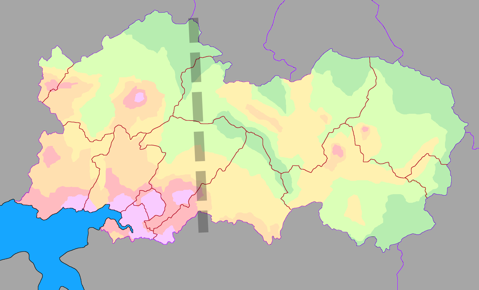
From the tripoint of Hemstein, UL12c, and UL12f, one could draw a line southwards, and split Hemstein in two. The six largest population centers (Wiemónsjtein (capital), Elcherbörch, Brènfort, Nuuëhaomsjtein, Antoniusvörke and Sint-Jaansjtein) are all located to the west of this line. The three ""-Sjtein"" cities among those form a large conurbation north of the estuary of the Hem rivers where a huge amount of the population of the country is located; Elcherbörch, the second city of the country, is also located nearby, with access to the same bay (at the current location of Gernhem). The infrastructure in the whole of this western area is quite modern, and reminds one of European countries, like Germany or Sweden. The bay area near the Hem consists of modern cities, while the coastline around the Potte's estuary is more industrialized. Inland, especially near the three big rivers, there is space for farmland and sprawling rural communities. This area might remind one of the real world regions around the borders between Belgium, Germany, France and Luxembourg.
East of this imaginary line, the country is much more hilly, and the country is less developed. There is less agricultural activity here, but the economy is more built around mining operations, tourism, lumber and animal products. There is a railway connection from the largest eastern cities (Oersem and Wietemtore) towards the capital, due to the prevalence of mining operations here, however the population numbers here are quite low, and the standard of living here is much lower than even the northern-western reaches of River Potte's basin. This area is more based on south Germany, though I intend to take inspiration from Eastern European rural areas as well.
| History & culture | |
|---|---|
| A brief description of the intended culture and language |
Hemstein's national language is Hemsteiner, which is a fictionalized version of Limburgish in the real world. Limburgish is a dialect spoken in the region around the tripoint of the Netherlands, Germany and Belgium, and especially the provinces of Limburg (NL) and Limburg (BE). A brief look at the Limburgish Wikipedia reveals why I chose for Hemsteiner to be a fictionalized version of the Limburgish language: every single page indicates which subdialect of Limburgish it is written in. Thus, Hemsteiner is my attempt to standardize a language for an independent Limburgish state, with rigidly defined grammar. Additionally, Kalmish is commonly spoken in the eastern few provinces. As a rule of thumb, the chances for someone who speaks Lentian to understand what a Hemsteinian is saying is at its highest around the capital; and gradually decrease the further away one travels; and for someone who speaks Kalmish, it's the inverse. The cities of Brènfort and Zuusjolt both claim that their language is the least influenced by either, and that ''they'' are the ones that speak the true Hemsteiner; although you'll probably find the ''purest Hemsteiner'' is spoken in rural villages anyway, not in the city.
The name "Häömsjteinbeed" divides into three parts; Häöm (the plural of Haom, the name given to both rivers whose shared estuary forms the economical heart of the nation), Sjtein (the plural of sjtein, in the meaning of "castles") and Beed (a suffix that means "area", which only appears as part of the toponym in the native language). In most Germanic languages, the country is referred to as Hemstein or a derivative, while in Romance languages, it is often referred to as Transnèvie (Valonian) or similar.
The culture is similar to that of the Dutch province of Limburg, with a population that's fond of cycling races, creamy pies, beer and Catholicism. Most villages are formed around a fortification, or a church. Despite its size, Hemstein, which functions as a parliamentary monarchy, is traditionally classified as a Grand Duchy. Historically, the country has existed for centuries in some capacity. For a significant duration, Hemstein was under Valonian rulers. The country is riddled with castles and fortifications, which can be seen from placename suffixes such as -sjtein, -börch and -fort. The exact relations with each of its neighbours are to be explored after the application is approved; in particular the history and relations with Atresia are quite likely to be interesting, but Hemstein is more reliant on foreign trade than most other countries. Internally, Hemstein is divided into 12 cantons (kantónne / rajonne); of which two are special autonomous regions (Ajjèmbörch in the northwest, and Helmser Dörpe in the east). These are subdivided into roughly municipalities (gemeindes) are the smallest subdivisions in the country.
I chose this location, as it struck me as the most potent spot for a Limburgish nation, being wedged between a large block of Dutch language nations and a hub of German(ic) nations. UL11e also is a territory which could be applicable, but I found it to be too wet, and too prominently located for a nation with the (lack of) economic strength I am proposing.
| Past mapping | |
|---|---|
| To support your request provide links to areas of OGF mapping which showcase your mapping skill. Mapping relevant to the requested theme & geography is especially useful. | |
| The {{coord}}, {{node}}, {{relation}} or {{scalehelper}} templates can optionally be used to link to the OGF map - they result in nicely formatted links. Or you can paste in a URL. |
This request is for an exchange of the TA321 territory (Aerágny) for UL11f.
As much as I enjoy the Aerágny project, it's one that's been suffocating my enjoyment for mapping for a while; as if I'm forcing the square peg that is my ambition for Airannia, its language and culture, into the round hole that is OGF. This is why I'm intending to swap to a territory where I'd be able to map more care-freely, and keep the Airannia project (in particular its language) off this map.
Ulo:
Airannia:
- Michaelon valley: [3]
- Sambourly and its Lower Villages: [4]
- Jordan and Cascagnois: [5]
- Southern Watseun: [6]
- Pantájy machre: [7]
Additionally, in the Alexanderton area [8] I've been working on a showcase area for this application to be moved into the territory should the application be approved. As you can see, it isn't yet finished - however, I figured I would put forward this application ahead of completion, as I'm eager to begin the application process, see where I stand, and will most likely continue developing this showcase area in TA321 while the application is under review. Also please note that, as a result of me clearing most of TA321 about a half year ago, a large amount of other regions I've proudly worked on in the past are no longer currently visible on OGF. I have the removed mapping saved locally, but out of courtesy to the servers, I won't re-upload it just for the sake of showcasing, but if there is anything in particular that might be requested, I could share screenshot of the .osm file.
| Username & date | |
|---|---|
| Sign and date the application by typing four tildes (~~~~) without spaces or "nowiki" tags. |
Lever doed ingès Beedse, daan eljes in leve! (Rather dead in Hemstein, than alive elsewhere!) - Taka (talk) 22:09, 8 February 2026 (UTC)
 | Discussion |
|---|---|
| Discussion for clarification & decision |
 |
Territory application approved |
|---|---|
| See notes below signature. — Alessa (talk) 02:17, 10 February 2026 (UTC) | |
| Thanks for the application, Taka. Looking forward to having you in the region, and the concept is great. It'd be fun to have a Limburg-inspired cultural space on the map. It is a touch bittersweet, as you invested so much in trying to make Airannia fit within OGF, but I understand what you mean in your rationale. Please let us know when the former territory in Tarephia is officially cleared, and please let me know when you want me to start the wiki cleaning process. I will gladly give two weeks if you need it before clearing out anything in case you decide to repurpose old flags or whatnot. Feel free to move whatever you'd like to the new territory both on the map or the wiki. Cheers! |