Forum:Territory application/UL25f - Mistland
- Please fill in the information below to make a territory request.
| Territory ID and proposed name | |
|---|---|
| The Territory ID (from OpenGeofiction:Territories, e.g. AR123a) and proposed name of the country |
| Physical geography | |
|---|---|
| An overview of climate, topography and landscape of the country. With the exception of Beginner territories, you should always create a sketch map to illustrate & explain your plans. You can add a link to this (hosted on imgBB, Postimages or similar, but not imgur.com) |
Topographic sketch on top of current world map: Mistland-topographic-sketch.png
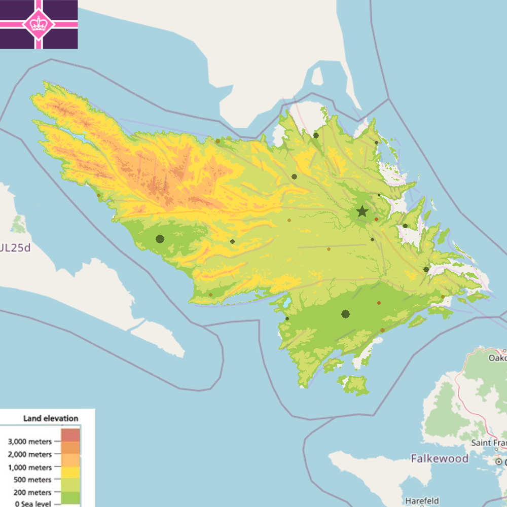
I started sketching by observing the way surrounding land is spread out to determine where potential faults may be. I sketched out major and minor faults, which you can see being represented by the very transparent, indigo (low activity) to pink (high activity) lines. I made the assumption that the chain of islands coming out from ![]() Eshein and extending all the way to UL25f are formed by a major tectonic plate boundary. That boundary ends near my capital where it meets another presumed plate boundary - one which forms the island chain starting at
Eshein and extending all the way to UL25f are formed by a major tectonic plate boundary. That boundary ends near my capital where it meets another presumed plate boundary - one which forms the island chain starting at ![]() Kadah and ending at
Kadah and ending at ![]() Östermark.
Östermark.
The collision of said plates fractures the geology somewhat, creating the dynamic hills and iconic highlands in the north and especially north west of the country. The highest peak is around 3200m - a dormant volcano covered by a small glacier.
Most of the centre of the mainland is rolling hills and low-lying plateaus perfect for farmland, grazing, forestry, and fruit industry alike. The sub-200m south is marshy and home to many ancient forests that have been used as worship and pilgrimage sites by various religious for thousands of years. Thus, even though it's fertile land, most of it is protected and kept as wild as possible.
Climate-wise, everything below 1000m has temperate marine climate (Cfb), while most areas above 1000m have subpolar oceanic climate (Cfc). A lot of the mountain peaks above 2500m are tundra (ET).
 | Human geography |
|---|---|
| A brief description of the territory demographics, economic development, land occupation, infrastructure and mapping style |
Refer to the map above for population distribution. Black dots are historic settlements, brown are those that rose during the industrial revolution, and red are post-industrial creations. The capital (marked by the star) is the biggest city with 500K to 800K residents. The two other big cities are about 250K each. The three medium-sized dots (10px) area 100K each. And so on; you get the image. It's a fairly rural country.
Mistland is a developing, state capitalist, upper-middle-income economy. It has extensive mineral deposits: coal, iron, copper, zinc, lead, chromium, tungsten, tin, and sulphur. The core exports include metals, minerals, chemicals, pharmaceuticals, wood, clothing, furniture, weapons, and entertainment. Mistland, during the average year, produces enough geothermal, hydroelectric, and wind power to fully sustain itself.
Since Mistland has always been more or less authoritarian and traditionalist, but never too far left or far right economically, its agricultural land is often distributed in large zones. Yet, those zones are not as large as they were in, for example, the Soviet Union. They respect traditional boundaries, historical duchy borders, etc. Often, boundaries and fields are maintained for ideological and symbolic reasons rather than efficiency. Another quirky element is regional specialisation e.g. "the orchard belt", "the dairy province", etc. This reinforces regional identity, cultural pride, and economic planning.
So, when it comes to mapping, what you'll see from me in Mistland is less scattered fields than in the UK (or my previous countries on here). However, the fields won't be Soviet level massive either. Instead of collective farms, Mistland will have farmers renting big agricultural areas from the state, as well as heritage farmers who almost see themselves as mini dukes. You will still be able to find a few smaller farms and fields that resemble northwestern/central Europe, but they'll be outliers.
As for infrastructure, I suppose railways will be quite extensive since there is a lot of mining going on. Due to the country being green and traditionalist, motorways will be largely avoided (within reason) and the country will try its best not to be car-centric. Romanesque, Baroque, and Renaissance architecture (and their modern (local) derivatives) dominate.
| History & culture | |
|---|---|
| A brief description of the intended culture and language |
As I have mentioned in the previous section, the country has always been authoritarian, whether that's theocracy, absolute monarchy, or authoritarian democracy. Since authoritarianism is so ingrained in the psyche of the nation, it has become part of the culture. It's a patriarchal culture full of worship for the leader, the national religion, the land, and God. The leader is seen as the vessel - or the crowned body - through which connection to God is made and power to rule is given. Spiritual rituals of worship and humility are commonplace, both for the common people and the ruling class.
In a nutshell, the culture revolves around respect for tradition, religion, spirituality, rituals, worship of God and leader, patriarchy, humility, sensuality, fertility, and perseverance in the cold and misty weather. I would struggle to find perfect comparisons to real countries. Perhaps a mixture of Vatican City, Afghanistan, and UK? I don't think it's fair to compare Mistland's culture like that, though. It's very much a conculture that I created without thinking of any real life countries.
When it comes to language, it's a bilingual country. I'll be using a modified version of English (call it Mistlandic English). The second language will be a conlang. I'll basically be taking my Ostrian conlang - place names of which can be seen in ![]() Merhalen, Igria, and parts of Keira - and making it more English and otherwise more Germanic.
Merhalen, Igria, and parts of Keira - and making it more English and otherwise more Germanic.
The bilingual situation is comparable to places like Ireland i.e. 95% of people will be fluent in Mistlandic English, but only 20% to 35% will speak Mistlandic [Conlang]. Both languages will be present across the whole country. That being said, the capital, eastern coast, and the south are the most English-speaking. The north and west are the most [Conlang]-speaking.
However, I think it's fair if the place names reflect an even more layered history. I'll mix in some old fragments of Indo-European into place names to show that the land was inhabited even before [Conlang] speakers (let along English speakers) migrated there.
| Past mapping | |
|---|---|
| To support your request provide links to areas of OGF mapping which showcase your mapping skill. Mapping relevant to the requested theme & geography is especially useful. | |
| The {{coord}}, {{node}}, {{relation}} or {{scalehelper}} templates can optionally be used to link to the OGF map - they result in nicely formatted links. Or you can paste in a URL. |
My most extensive mapping was done on the triplets of Tuyaria i.e. Keira, Igria, and Merhalia [[[File:OGFmapicon.png|20px|link=]] 52.019°N, 117.026°E].
Before that, I had an attempt at a South Archantant country before I realised I wasn't interested in that type of linguistics and culture. It was called Ulihraad and is now a part of Neo Delta [[[File:OGFmapicon.png|20px|link=]] 53.5762°S, 135.4504°E]. The bay and 95% of the coastline are my work. Same with place names, although most of them have been shortened.
I'm also technically responsible for this string of settlements in AR293 [[[File:OGFmapicon.png|20px|link=]] 14.7191°N, 141.4078°E]. I can't say I'm proud of them, though.
I was also active on OSM for a while in 2018-20.[1] I mainly mapped with iD, so the mapping wasn't anything impressive, and I'm certainly not proud of it. However, I think it's important that it's understood that I came from OSM and am aware of OSM mapping conventions.
| Username & date | |
|---|---|
| Sign and date the application by typing four tildes (~~~~) without spaces or "nowiki" tags. |
Halvarda (talk) 17:41, 4 May 2026 (UTC)
 | Discussion |
|---|---|
| Discussion for clarification & decision |
 |
Territory application approved |
|---|---|
| I usually do not approve territory applications right after submission but try encourage some more elaboration on aspects I find lacking - but I couldn't find any here :) Great submission and interesting proposal. Happy mapping! Leowezy (talk) 17:52, 6 May 2026 (UTC) | |
| As you develop your territory, be sure to keep it realistic. Here are some resources you may find useful for starting out: Help:Portal, Help:Making realistic countries, Help:Making realistic cities and OpenGeofiction:Site policies |