Forum:Valonne/Nemans - Infrastructure
Transportation
Roads
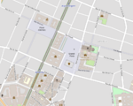
This is an issue/suggestion about a small section of Nemans, but I would like to discuss the following: just southwest of the city centre of Nemans, the Avenue des Colonies can be found. It goes on for about 1km, when it becomes the Avenue d'Ardence, which ends at the Place d'Ambroisie. I think it would look better if Avenue des Colonies continued until Place d'Ambroisie, with several rues and avenues that carry the names of former colonies branching off from it. Place d'Ambroisie could get a new name (like Place d'Olers, as it's at the start of the road to Olers), and a new Avenue d'Ambroisie could come closer to the city centre. I think this would give that section of Nemans a more cohesive feeling. Again, this is a small detail of Nemans, but I think it would add something to the cohesiveness of Nemans. Mantan (talk) 20:09, 5 November 2024 (UTC)
- Sure, you can rename the whole stretch Avenue des Colonies. You can also blank the Place d'Ambroisie name and have one Avenue d'Ardence and one Avenue d'Ambroisie perpendicular to Avenue des Colonies, more or less where Métro stations "Station" and "Ardence" are found. --Aiki (talk) 04:37, 6 November 2024 (UTC)
Railways
Trains
West Station
Nemans is endowed with 3 main historical railway terminals:
- Gare du Midi - South Station
- Gare du Levant - Orient/Levant Station
- Gare du Nord - North Station
Additionally, two lesser stations exist, mainly for suburban services:
- Embarcadère Saint-Vincent - A former small mid-19th century station designed to enable the king to travel from the City's château to his domain along the lake and now providing "limited" services to East and NE suburbs.
- Sainte-Léonie - Across the Yse River in Delautre, serving North and NW suburbs.
- Potentially a 3rd small terminus station for western destinations, but likely now destroyed. Replaced by 1960s/1970s brutalist Gare du Ponant (West/Sunset Station] passing station.
Passing station proposal - Gare du Ponant Complex
Due to the lack of a larger station serving western destinations in Valonne and, international destinations such as cities in Kalm, the government decided sometimes in 1960s, to build a large complex combining a train station, a bus station, offices and a shopping centre. The Gare du Ponant (or West Station) was build in the late 1960s/early 1970s, likely in a mixture of brutalist and international styles favouring slabs to divide each function, on the location of a good station, warehouses and working class neighbourhood. The whole area was bulldozed and Nemans railway bypass tracks buried under a concrete slab. In layers, one would find:
- The Premier Périphérique, access to A01 motorway, branches and branches of underground interchange
- Railways tracks and Gare du Ponant plateforme, probably the bus station as well
- Local destination roads/street, car-access to the station + parking lots
- Station hall, shopping centre, pedestrian concrete slabs with bridges jumping from one slab to its neighbour
- Office buildings and potentially some residential one.
Here are the questions I have so far:
- Does the overall plan make sense?
- If so:
- How many tracks should be considered for such a passing station: 6, 8, 10 or else?
- Was the project completed with a reshaping of the neighbour or was it just limited to the station?
- This kind of shopping centre experienced, in Western Europe, some kind of a slump in the 1980s and 1990s. Should we considered a successful later facelift (e.g. parks on the slab) to be featured on the map?
- Should we consider a high-end, Barbican-typed of residential buildings or gloomier type like Créteil or some areas of Paris' La Défense quarter with concrete bars and towers of public housing?
--Aiki (talk) 09:43, 23 October 2024 (UTC)
- It could be an area that has gotten recent urban renewal, it's a relatively important location to be left rotting for long. Probably not for a central business district area, but for some kind of dense walkable housing quarter with cultural and art facilities alike many urban renewal projects in Europe.
Likewise I believe that not the entire area should be renewed but some older structures could be mapped as ready for demolition. ⸺ Bixelkoven (talk) (West Uletha Admin) 12:29, 26 October 2024 (UTC)- It does make sense. A few blocks destroyed to make room for the core of a project that was never completed: the station was built with some overground buildings built on the central slabs, but large chunks of the original neighbourhood were left untouched. The whole thing being renovated in the last 15-20 years. There are some smaller examples I can think of in Paris: Olympiades, Paris "Chinatown" that once had a goods railway station under the slab, and higher-end Beaugrenelle. In terms of layer:, that means we may have something like:
- -4 and below: A01 motorway and its accesses/interchange
- -3 Railway tracks, Bus Station
- -1/-2 Parking lots access to bus station plateforms
- 0 Local destination roads/street: car access to the stations and parking lots
- 1 Station hall, shopping centre & pedestrian slab(s)
- 2 and above: any building built on the slab(s).
--Aiki (talk) 03:35, 28 October 2024 (UTC)
- It does make sense. A few blocks destroyed to make room for the core of a project that was never completed: the station was built with some overground buildings built on the central slabs, but large chunks of the original neighbourhood were left untouched. The whole thing being renovated in the last 15-20 years. There are some smaller examples I can think of in Paris: Olympiades, Paris "Chinatown" that once had a goods railway station under the slab, and higher-end Beaugrenelle. In terms of layer:, that means we may have something like:
Rapid transit
General Plan
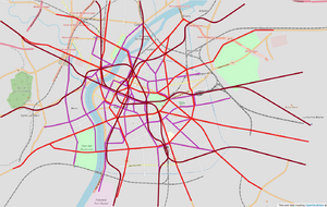
I propose a system like this, which is similar to irl:Paris but not identical, so as to keep things unique.
- Bright red is the early 20th century elevated light metro with small trains and close station spacings.
- Purple is the "tramway ancien" that was also built around the turn of the 20th century but was, unlike in Paris, never demolished.
- And, finally, Dark red would wither be a modern heavy metro or RER built after the 70s (maybe it could even be a bit quirky and run on rubber tyres?).
Of course, this proposal is only a framework and as such is not meant to be taken completely as-is and any suggestions and modifications are fully welcome.
Sergjack (talk) 00:53, 30 October 2024 (UTC)
- Thanks Sergejack. The city project and its public transportation system are quite at their infancy but this provides a good framework when we reach that point: some features of the city are already there, but it's a bit early in its development to know where most people live and where the work/shop to draw all the lines. For the tram, I'd say, this would need to be discussed with other collaborators as it's a "major" distinction with IRL Paris. --Aiki (talk) 05:37, 31 October 2024 (UTC)
- Hi All,
Does anyone some input before Sergejack starts implementing bits of the central sections of the above proposal?- Metro: from my understanding, the plan departs largely from IRL Paris with most of existing underground stretches to be moved on elevated viaducts. IRL Paris, historic metro lines are rarely above ground. Main examples are lines 2 and 6 that run long distances above the median strip of large boulevards that surround Paris's core, or crossing of the Seine River: Pont de Bercy, Viaduc d'Austerlitz and Pont de Bir-Hakeim. So far, the already-mapped sections seem to follow this pattern.
I can't find the exact reference (incl. drawings) at the moment, but some projects existed during the second half of the 19th century for elevated train lines (then steam-powered, not unlike contemporary El in New York) in Paris. Those projects were opposed on the ground that the viaducts would disfigure Paris avenues. As it may seem unlikely Nemans went the complete opposite way, what is your opinion on the matter? - Tram: being far from a specialist to consider how the tram system should have looked liked if they were not removed in the 1940s-1950s as in most of French cities, I do not have solid opinion on the matter . For Paris area, you may have a look at this gif, dark green being electrified trams. Alas, the article exists only in French and German for those who can read either. Any enlightened opinion/advise from the OGF larger community is welcome.
--Aiki (talk) 06:56, 3 November 2024 (UTC) I think Sergjack's proposal is great; it isn't exactly Paris but it would still be fitting for the large metropolis Nemans will be. The mix of metro, heavy metro and tramways would be very nice. --Mantan (talk) 12:58, 3 November 2024 (UTC)- I think it is bit too early for mapping out whole metro and tram system as of now - it could be done later when the road layout will be more definitive, either in a spontaneous or a planned way. I believe that public transit is easier to lay out when main road and rail corridors, as well as points of interests/landmarks are decided. In OGFC Discord server, I recommended less trams and more metro in Sergjack's plan, and some people seconded my opinion (I encourage them to share their insights here, too). My idea was that trams exist nowadays only on the right bank of Yse (west side, e.g. Rens and Saint-Lambert area), in a manner of older, historic trams like in Lisbon, and geographically somewhat limited like in (East) Berlin, while the rest of the city (central and eastern parts) are served by metro only, in Paris style. Some people liked that idea too, maybe I can map out a vague proposal later to explore the idea further. Ante44 (talk) 13:36, 3 November 2024 (UTC)
- I feel Ante44 makes sense. Regarding the large elevated network in the centre, I keep being rather sceptical, scepticism reinforced by the rendering along Avenue de Valonne. I really doubt a French-like country, with its emphasis on culture preservation, would have accepted the perspective or the view of historic buildings along the avenue to be challenged that way. That being said, metro running on viaducts or at level outside the centre (~roughly from the boulevards circling at Gares du Midi/Levant level) would have encountered less imaginary opposition.--Aiki (talk) 11:22, 10 November 2024 (UTC)
 Nemans elevated metro by Sergjack
- Metro: from my understanding, the plan departs largely from IRL Paris with most of existing underground stretches to be moved on elevated viaducts. IRL Paris, historic metro lines are rarely above ground. Main examples are lines 2 and 6 that run long distances above the median strip of large boulevards that surround Paris's core, or crossing of the Seine River: Pont de Bercy, Viaduc d'Austerlitz and Pont de Bir-Hakeim. So far, the already-mapped sections seem to follow this pattern.
- Hi All,
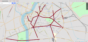
Extent of tunneled network
Here is a map that was agreed to on the discord server regarding the metro sections that would be tunneled. Unless objections are made here I will move forward with implementing this proposal.
Sergjack (talk) 22:16, 29 November 2024 (UTC)
- Thank you, Sergjack. It looks good to me and in line with a rather slow, organic growth that enables some leeway for future adaptation. I've just widened Boulevard des Halles so that the viaduct runs over a median strip, as in Paris, and not over the actual street as it does in Downtown Chicago. I've also renamed Rue des Cerises/Cerises station to Rue des Maraîchers/Maraîchers (market gardeners) as I felt it was more in line with the nearby covered market, former Halles and, fruit-named streets sound a bit more recent (from the late 1960s) suburban developments with culs-de-sac, looping streets and middle/middle-upper class villas.
--Aiki (talk) 06:03, 3 December 2024 (UTC)
RER-like network
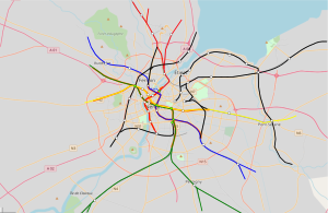
Here's a very brief draft for the central tunnel section of a potential RER-like network. The East and South portals are located at railway junctions/yard while the west and north exits have not be thoroughly considered. These 3 lines converged to a central station under the Place d'Armes with 2 of them meeting again next to the Gare du Ponant/Western business centre. Any thoughts on the draft? --Aiki (talk) 11:22, 10 November 2024 (UTC)
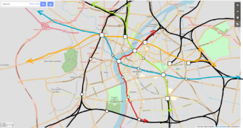
Here's a draft based on the current RER lines in Nemans (all named RER N at this stage). The colours correspond more to a set of tracks than to specific services/lines while the black lines correspond to the historical railways that are probably used by commuter trains as well. The RER runs on dedicated tracks in its central section, most built in deep tunnel (except the red line that runs just under River Yse quays) and emerges to connect to the regular railways network in the inner suburbs. Existing stations are marked by white dots while the green ones are "major" station complexes: Midi/Gare du Midi, "Grand Rond", Valonne/Place d'Armes, Gare du Ponant and Gare du Nord. At this stage, my questions to Nemans collaborators and the wider OGF community are:
- Would you consider this first step as a core consistent enough to be used as based for further enhancements?
- What would you recommend?
- Would you consider redirecting line blue a bit further north (dotted line in the central section) so that it crosses red line and other suburban lines at Gare du Nord?
Many thanks. --Aiki (talk) 09:46, 30 March 2025 (UTC)
Hi Aiki,
To me this seems a good core, it crosses the historic city centre and the lines (if extended) can become important axes for residential and commercial developments. It will have to be enhanced though, of course, but the black and red lines especially look like they will become the lifelines of Nemans. A special line that connects Gare du Midi or maybe Levant to the airport south of the city would be good too, I think. Regarding the dotted blue line, I think that would be a better fit as 1) it connects to Gare du Nord and 2) the curve looks more realistic. In general, this looks like a great core system to me, but then again, I'm not too educated on transportation matters ;) --Mantan (talk)08:33, 31 March 2025 (UTC)
- Thank you for the feedback. I redirected the line via the Gare du Nord though the previous version didn't have a curve as sharp as on the map ;-) Most of the black lines correspond to 4-6 tracks to cope with long distance/express services and local services, either RERs coming in and out of the central tunnels or commuter trains from the large termini. I agree, I feel one of the RER lines + regular trains should reach Nemans airport(s). I suppose "exactly how" will depend on how the suburbs developed.--Aiki (talk) 23:37, 4 April 2025 (UTC)
I also tried to sketch something on my own, adjusting what I thought could be improved, while trying to preserve as much the already mapped network. I would personally go with two lines connecting east and west (orange and blue), and two lines roughly connecting north and south (red and green). Orange line would connect all the main train stations on the north (Gare du Ponant - Sainte-Léonie - Gare du Nord - Gare du Levant) while also connecting eastern and western suburbs simultaneously. I didn't include Emb. Saint-Vincent there, as a less important terminus that would serve local trains towards the northeast, and because it's also quite close to Gare du Levant. Blue line would connect east and west, but through the very core of the city, using one of the mapped corridors. I chose the variant via Narmet in the sketch, it feels redundant to have both Narmet and Osianople variants connecting Gare du Ponant and Place d'Armes; Place d'Armes could be connected to Sainte-Léonie via Osianople using regular metro line. RER under Avenue de Valonne (section from Armées to Place d'Armes and further southwards) also feels redundant to me, as there is metro line under Avenue de Valonne that would probably stretch all the way from Gare du Nord to Arcades and further. Instead I think it would be more feasible to connect north and south from Sainte-Léonie to Midi with connections and stops at Nemansois (connection to red line), potentially Esplanade des Armées/Victoires (connection to metro lines, but it's very close to Nemansois, so it could be opted out as well), and Grand Rond (connection to blue line and metro). Generally, all the mapped stations would also have a metro connection. Red line would stay as described in your previous comments. Additionally (not sketched), I think there could be at least one more major rail terminus on the east (somewhere in Rens?). Nemans is a city supposed to be larger than Paris, in a country larger than France, so only four termini seems a number too small compared to Paris' ~6 main termini. Let me know what y'all think about this! :) Ante44 (talk) 15:25, 13 April 2025 (UTC)
Hi all,
Good core for the RER-like network. I see that north-east Nemans doesn't have a line, is it because of Embarcadère de Saint-Vincent line ?
Could one of the lines be reserved to terminate at the future Nemans International airport (for instance, the green line) ? It could be a direct link to the city center via the future suburbs. Sweetykid (talk) 21:38, 13 April 2025 (UTC)
- Hi Ante44,
I like your addition of the orange line. I wonder if the NE branch shouldn't emerge around Vercueil and take over some if not all services from Embarcadère de Saint-Vincent on the https://opengeofiction.net/relation/445062? I feel one of the S or SE lines should somehow still reaches Gare du Ponant business area instead of two east-west lines. For the historical Red Line, I wonder if, instead of reusing the south end junction, it shouldn't go on in a newly built tunnel to serve suburbs around Saint Antoine? So far, the tunnel portals that I built are the following:
- La Butte-Saint-Louis with a branching allowing access to both lines forking further south:
- Vintoise joining the Nemans - Bourderoi Line
- Gare du Nord with a fork to provide access to both lines once the Yse River is crossed: N and NW lines. The southernmost bridges are thought to be the original, while the other pair was added a few decades later.
- Gare Sainte-Léonie accessible for the western line.
As for an additional long distance station, I suppose it would make sense. The original idea was to have it torn down and replace by the modern Gare du Ponant, even if not at the same location. Maybe Lercy Station? With additional tracks that stop there or merge with the quadruple tracks that run through Saint-Lambert and Ponant Station, meaning that most long-distance trains from the SW would terminate there, while those only stopping in Nemans would stop at Ponant and continue somewhere north? Lercy can be moved a bit to the south to have easier metro connection at Porte d'Olers?
--Aiki (talk) 12:44, 16 April 2025 (UTC)
Waterways
River Port
I think Nemans should have two major river ports. The main one on the lake and a smaller but equally important river port on the Yse, which would allow ships from the south (Rivador, the Mesembric Sea) to unload their cargo earlier without the need for them to go through the city, clogging the river with barge and ship traffic. Reminder that this river is an important route between the Mesembric and the Great Rift area. ⸺ Bixelkoven (talk) (West Uletha Admin) 12:29, 26 October 2024 (UTC)
- Likewise, I think most of the older bridges in Nemans should be drawbridges of some sorts, to allow ships to pass. ⸺ Bixelkoven (talk) (West Uletha Admin) 12:29, 26 October 2024 (UTC)
- I suppose boats on the Yse will be barges, a type that, I suppose, does not seem well-suited for the Lake Glois (which is large, but not sea-like-large) - I may be completely wrong on the matter. I feel unloading/loading twice may be a bit cumbersome. Though I'm not oppose to having 2 ports, maybe one of the would be dedicated to the usual transshipment for goods passing through Nemans area (likely the one close to the lake), while goods stopping at Nemans will be unloaded at the first port on their way: upstream for the north and downstream for the south.
- For drawbridges, it all depends on how tall those ships are expected to be. I can think of the French-made Trinity Bridge in St-Petersburg, but in that case, seaworthy ships are concerned. --Aiki (talk) 03:54, 28 October 2024 (UTC)
- If clogging of the river in Nemans was a problem at a certain period it is likely a canal was build to bypass the city completely in the 19th or early 20th century. This would also in the city having two ports. There's already the Canal d'Auriève, but that might still be too close to the city.
- Imperator (talk) 19:40, 5 November 2024 (UTC)
Canals
Airports
- Aéroport de Nemans-Villegis (NVG / JVNE) - Smaller historical airport
- Aéroport de Nemans-Vaux (NVX / JVVX) - Larger southern airport
- Aéroport de Nemans-Godefroy (GDF / JVGF) - Larger western airport
- Aéroport de Larcelet (LRC / JVLC) - Smaller airport on the outskirts of the metropolitan area
Main Public Building
Government
National
- Parliament Building
- Interior Ministry
- Education Ministry
- Ministry of Hearth
- Ministry of Finance
- Ministry of Defence
- Nemans Courthouse
- Main Post Office
Local
Embassies
Embassies may need to be moved from their related "ethnic" neighbourhoods to fancy/fancier ones where diplomatic offices are usually located
| Country | Name | Diplomatic | Representing in
|
|---|---|---|---|
| Antharia | Ambassade d'Antharie | embassy | Valony |
| Gobrassania | Ambassade de Gobrassanie | embassy | Valony |
| Lentia | Ambassade de Lintique | embassy | Valony |
| Ingrea | Résidence de l'Ambassadeur d'Ingrée | embassy | Valony |
| Brasonia | Ambassade de Brasonie | embassy | Valony |
| Floresecenta | Ambassade de Florescente | embassy | Valony |
| Novakia | Ambassade de Novaquie | embassy | Valony |
| Federal States of Archanta | Ambassade des États Fédéraux d'Archante | embassy | Valony |
| Ingrea | Ambassade d'Ingrée | embassy | Valony |
| Federal States of Archanta | Résidence de l'ambassadeur des États Fédéraux d'Archante | embassy | Valony |
| Federal States of Archanta | Consulat général des États Fédéraux d'Archante | consulate | Valony |
| Guai | Consulat général de Guai | consulate | Valony |
| Guai | Ambassade de Guai | embassy | Valony |
| Demirhan Empire | Ambassade | embassy | Valony |
| Plevia | Ambassade | embassy | Valony |
| Plevia | Résidence de l'ambassadeur | embassy | Valony |
| Résidence de l'ambassadeur | embassy | Valony | |
| Résidence de l'ambassadeur | embassy | Valony | |
| Résidence de l'ambassadeur | embassy | Valony | |
| Résidence de l'ambassadeur | embassy | Valony | |
| Résidence de l'ambassadeur | embassy | Valony | |
| Résidence de l'ambassadeur | embassy | Valony | |
| Résidence de l'ambassadeur | embassy | Valony | |
| Ambassade | embassy | Valony | |
| Ambassade démirhane | embassy | Valony | |
| Consulat général de Plévie | consulate | Valony | |
| Ambassade de Plévie | embassy | Valony |
Health
| Name
|
|---|
| Hôpital Saint-Luc |
| Hôtel des Armées |
| Institut Berger |
Education
University
| Name
|
|---|
| Faculté de Médecine de Nemans-Saint-Luc |
| Université de Nemans - campus Toussaint |
| Université de Nemans - Cité |
Secondary
| Name
|
|---|
| École Saint-Fiacre |
| Lycée Lucien Dalasque |
| École Publique Sainte-Anne |
| École Primaire Publique Godefroy III |
| Lycée Maréchal Marbois |
| Collège-Lycée Saint-Matthieu |
| École Primaire Amélie Catou |
Religious
Ortholique
Roman Catholic
- Cathedral of Nemans
- Église Sainte-Anne
- Église Saint-Théodore de Chéron
- Église Saint-Louis-en-Ville
- Chapelle royale
- Église Saint-Philippe-du-Petit-Ruisseau
- Église Saint-Michel de Kirchembourg
- Abbaye Saint-Matthieu burial place of Kings of Valony.
Culture
Museums
Theatres
- Grand Palais d'Ulèthe Likely houses concert hall, potentially an opera house and a theatre as 3 halls are mapped
