User:Varnel maiser/Sandbox
Back to: User:Varnel maiser
FSA
Deodeca
Cabelia/TCC
Joriskjo P-25-04
-
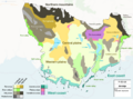 Geographic regions
 -
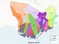 Watersheds
 -
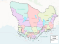 Political divisions
 -
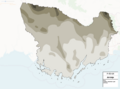 250 m broad contours
 -
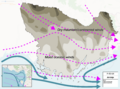 Estimated wind and wave map
 -
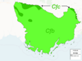 Köppen climate types


A selection of high-level plans I have prepared for ![]() Joriskjo, based on the continental plans in OpenGeofiction:Antarephia. Please feel free to comment below. Thanks!
Joriskjo, based on the continental plans in OpenGeofiction:Antarephia. Please feel free to comment below. Thanks!