|
|
| (17 intermediate revisions by 2 users not shown) |
| Line 1: |
Line 1: |
| The Province of Agawaskway is a closed collaborative territory in eastern [[Collab:Deodeca|Deodeca]]. It is inspired by the [https://en.wikipedia.org/wiki/Golden_Horseshoe Golden Horseshoe] region, and surrounding areas of Ontario, Canada. It will feature an urban, Toronto-like metropolis along with other, smaller cities, and mostly rural regions beyond that. On its eastern shore lie the Federal States (specifically, the state of [[Minnonigan]]), and the Grand Lakes Amanecer and Betaouais. Lake Betaouais is similar in size and shape to [https://en.wikipedia.org/wiki/Lake_Ontario Lake Ontario].
| | <gallery mode="slideshow"> |
| | | File:DE-AA banner.png|Quentinsville, by {{OGF user|CartographerKing}} |
| [[File:Drapeau_Agawaskway.svg|300px|thumb|right|Flag of Agawaskway]]
| |
| | |
| = Information = | |
| Agawaskway has a population of 9 497 000, the majority of whom live in the largest and capital city of Kingstown (and its extended urban area). This map shows the Kingstown Grand Metropolis, the "official" metropolitan area of Kingstown.
| |
| | |
| {{#multimaps: | service = OGF | center = {{{latitude|-42.4493}}},{{{longitude|139.3197}}} | width = full | height = 700px | zoom = {{{zoom|10}}} | maxzoom = 14 | minzoom = 1
| |
| | overlays = +KGM
| |
| | overlaydef = {
| |
| | |
| "KGM": {"function": "boundaryRelation", "param": {{{relation|305447}}}}
| |
| | |
| }
| |
| }}
| |
| | |
| The following gallery showcases the base plans for the province. Click on each image to learn more.
| |
| | |
| <gallery>
| |
| Agawaskway baseplan admin.png|Administrative divisions
| |
| Agawaskway baseplan transport.png|Transportation corridors
| |
| Agawaskway baseplan plss.png|Grid plan
| |
| </gallery> | | </gallery> |
|
| |
|
| {| class="wikitable"
| | '''Agawaskway''' is a collaborative territory in [[Collab:Deodeca|Deodeca's]] Lakes Region. It is inspired by the [https://en.wikipedia.org/wiki/Golden_Horseshoe Golden Horseshoe] and [https://en.wikipedia.org/wiki/Melbourne Greater Melbourne] regions, and surrounding areas of Ontario, Canada. |
| | style="background: #D5B942; color: back"|[[File:Emb-yellow.png|20px]] '''Advisory:'''
| |
| | style="background: #E3DE8F|This gallery will be updated on a regular basis to reflect changes to the plan.
| |
| |}
| |
| | |
| '''The first map''' shows the administrative divisions and major population centres of Agawaskway. The province is divided into a collection of Counties and County-level Cities, somewhat following the [https://en.wikipedia.org/wiki/List_of_municipalities_in_Ontario dual-tier system in southern Ontario]. While project participants will not be bound to a single county, users should not interfere with others' work, whether they be other contributors, or stateowners in the neighbouring areas of Deodeca or the Federal States. Most of the names on this map are subject to change and adjustment, to contributors' preferences.
| |
| | |
| '''The second map''' outlines the major transportation corridors of the province. With a few exceptions, there should be no additions nor subtractions to the highways on this map (railways can be added as needed). Adjustments to the routing and edits to add detail to the highways are permitted and encouraged.
| |
| | |
| * Orange represents major, non-freeway highways (i.e. [https://en.wikipedia.org/wiki/Ontario_Highway_7 Highway 7 in Ontario]).
| |
| * Purple represents restricted-access freeways (i.e. [https://en.wikipedia.org/wiki/Ontario_Highway_401 Highway 401 in Ontario]).
| |
| * The dotted grey lines are major railway tracks.
| |
| | |
| '''The third map''' shows a general guideline for major grid systems in the region. Unlike regions of the Federal States, land was allocated so as to follow the coastlines of major lakes and rivers. The map is a guideline, not a rule, and conflicts between grid systems should not be a problem. Particularly in the northwest of the province, [https://www.openstreetmap.org/#map=10/44.0051/-80.9352 this area] should serve as a model.
| |
| | |
| Climate-wise, the entire region falls under Köppen type Dfb (Warm-summer humid continental), with very small areas in the northwest being Dfa (Hot-summer humid continental).
| |
| | |
| Please do not create any new cities with a population over 100 000. Agawaskway has been completely subdivided into 31 counties and county-level cities, each with calculated population values. Statistics can be viewed on [https://docs.google.com/spreadsheets/d/1OkM-GYdSnh8veUCrNDjo_Ewi5bPG6aTEtcGM_N3QItA/edit#gid=151891510 this spreadsheet].
| |
| | |
| = Kingstown =
| |
| | |
| '''Kingstown''' is the capital and largest city of Agawaskway. According to [https://docs.google.com/spreadsheets/d/1OkM-GYdSnh8veUCrNDjo_Ewi5bPG6aTEtcGM_N3QItA/edit?usp=sharing KGM Data], the city has an urban population of 3 002 000, with the Kingstown Grand Metropolis (KGM) having a population of 6 418 000. The region is quickly growing, with people from all over the OGF world moving and mapping there. It is one of the world's truly cosmopolitan cities.
| |
| | |
| Moving one step further, the greater region of Southwest Agawaskway (SWA) adds more distant cities to the "Kingstown" label, as well as very rural areas on the outskirts of the city. Combined, SWA has a population of 6 970 000.
| |
| | |
| The Kingstown Project is part of the closed collaborative territory Agawaskway, but is '''open to everyone''' wishing to contribute. All you have to do is message [https://opengeofiction.net/user/varnel_maiser varnel_maiser] with what you want to work on. It's a really straightforward process, and there's something for everyone in this project.
| |
| | |
| * '''''Note:''' "The Kingstown Project" encompasses all of SWA.''
| |
| | |
| From mapping ethnic enclaves in the city, working on realistic local and regional public transportation networks, and understanding complex administrative structures that form every government, there is always a need for mappers to contribute to this project. That's right, '''we need you to help us build this city'''.
| |
| | |
| The collaboration structure of the city is very loose, with contributors focusing on one ward of the city, one major system of the city, or making sporadic and occasional edits of all sorts. Deep collaboration and communication with other Kingstown contributors is a must.
| |
| | |
| == Dashboard ==
| |
| | |
| The KTM network does not render by default because I don't want to put too much load on the server 😃
| |
| | |
| {{#multimaps: | service = OGF | center = {{{latitude|-42.4493}}},{{{longitude|139.3197}}} | width = full | height = 1000px | zoom = {{{zoom|10}}} | maxzoom = 14 | minzoom = 1
| |
| | overlays = +SWA,KTM Queen-Millner,KTM Ring,KTM Crosstown,KTM Harbour Island,KTM Forberg-Flennigan,KTM Southwest
| |
| | overlaydef = {
| |
| | |
| "SWA": {"function": "boundaryRelation", "param": {{{relation|399380}}}},
| |
| "KTM Queen-Millner": {"function": "publicTransport", "param": [380540]},
| |
| "KTM Ring": {"function": "publicTransport", "param": [380541]},
| |
| "KTM Crosstown": {"function": "publicTransport", "param": [380542]},
| |
| "KTM Harbour Island": {"function": "publicTransport", "param": [380543]},
| |
| "KTM Forberg-Flennigan": {"function": "publicTransport", "param": [380544]},
| |
| "KTM Southwest": {"function": "publicTransport", "param": [380545]}
| |
| | |
| }
| |
| | |
| <!-- Kingstown Concentrated Ethnic Communities -->
| |
| | marker = -42.4406206, 139.2551847 ~Izakiville ~Izaland ~Marker-fedair-small.png
| |
| | marker = -42.4793454, 139.2420959 ~Bai Quarter ~Bai Empire ~Marker-fedair-small.png
| |
| | marker = -42.4759983, 139.2196671 ~Little Mallyore ~Mallyore ~Marker-fedair-small.png
| |
| | marker = -42.4851728, 139.2088929 ~Egaliatown ~Egalia Region ~Marker-fedair-small.png
| |
| | marker = -42.4743179, 139.2020836 ~Savier ~Suria ~Marker-fedair-small.png
| |
| | marker = -42.4959162, 139.1199323 ~Main Street Buren ~Lutang ~Marker-fedair-small.png
| |
| | marker = -42.420637, 138.9947319 ~Majatown ~Majesia ~Marker-fedair-small.png
| |
| | marker = -42.3977911, 139.0966129 ~Little Helan ~Commonwealth of Central Archanta ~Marker-fedair-small.png
| |
| | marker = -42.45385, 139.21852 ~Little Lechia ~Lechian Countries ~Marker-fedair-small.png
| |
| | marker = -42.45649, 139.17563 ~Jakop ~Joriskjo, Reàskuskjo ~Marker-fedair-small.png
| |
| | marker = -42.45556, 139.15486 ~Yoosterville ~Primarily Cabelia, but also other Lycene Nations ~Marker-fedair-small.png
| |
| | marker = -42.62730, 139.20529 ~Fairbyrne ~Anrovia ~Marker-fedair-small.png
| |
| | marker = -42.48359, 138.90881 ~Sandalorough ~Bai or Huaxia ~Marker-fedair-small.png
| |
| | |
| <!-- Schedule-able Airports -->
| |
| | marker = -42.51238, 138.95938 ~Chester Granby International Airport ~DKT, DKTN ~Marker-airport2a.png
| |
| | marker = -42.3578, 138.9041 ~Forberg Municipal Airport ~DFOR ~Marker-airport.png
| |
| | marker = -42.39558, 139.20462 ~Albertville Airport ~DKAB ~Marker-airport.png
| |
| | marker = -42.85736, 139.16952 ~(!) Kyle Kazowsky Airport ~DFLN ~Marker-airport.png
| |
| | marker = -42.1470, 138.5288 ~(!) Halkerston-Milfhouse International Airport ~DHL, DHLK ~Marker-airport.png
| |
| | |
| <!-- Government and Institutional Locations -->
| |
| | marker = -42.45074, 139.26298 ~(!) Parliament of Agawaskway ~Provincial Government ~Government_Icon.svg
| |
| | marker = -42.44892, 139.25989 ~(!) New Parliament Department ~Provincial Government ~Government_Icon.svg
| |
| | marker = -42.35013, 139.11156 ~(!) Ministry of Natural and Agricultural Resources ~Provincial Government ~Government_Icon.svg
| |
| | marker = -42.46376, 139.23570 ~Agawaskway High Court ~Provincial Government ~Government_Icon.svg
| |
| | |
| | marker = -42.46392, 139.23798 ~Kingstown City Hall ~Municipal Government ~Marker-historic.png
| |
| | marker = -42.46283, 139.23751 ~Clavis Building (City Offices Kingstown) ~Municipal Government ~Marker-historic.png
| |
| | marker = -42.66023, 139.40022 ~Nishowigan City Hall ~Municipal Government ~Marker-historic.png
| |
| | marker = -42.65964, 139.39504 ~Waters Region Headquarters ~Municipal Government ~Marker-historic.png
| |
| | marker = -42.50716, 138.88517 ~Millner Civic Centre ~Municipal Government ~Marker-historic.png
| |
| | marker = -42.18713, 138.66461 ~Halkerston District Court ~Municipal Government ~Marker-historic.png
| |
| | |
| <!-- Indigenous Lands -->
| |
| | marker = -42.2956, 139.5280 ~Mitigowi of the Island Treaty Lands ~Giishime, Name needs to be updated on map. ~Marker-housing-yellow.png
| |
| | marker = -42.5555, 139.3450 ~Mitigowi of the Lake Treaty Lands ~Giishime, Name needs to be updated on map. ~Marker-housing-yellow.png
| |
| | marker = -42.72119, 139.74424 ~Bain River Treaty Lands ~Giishime ~Marker-housing-yellow.png
| |
| | marker = -42.3634, 138.3422 ~Sakahi 76a ~Agawaskway ~Marker-housing-yellow.png
| |
| | marker = -42.9163, 138.9494 ~Sakahi 76b ~Agawaskway ~Marker-housing-yellow.png
| |
| | |
| <!-- Military Installations -->
| |
| | marker = -42.35902, 138.90389 ~RDAF Forberg ~ ~Marker-airforce.png
| |
| | marker = -42.39580, 139.42440 ~(!) RLG Bucketville ~ ~Marker-navy.png
| |
| | marker = -42.39982, 139.41420 ~(!) Camp Whites ~ ~Marker-army.png
| |
| | marker = -42.4896, 138.4212 ~(!) RDA Balto ~ ~Marker-army.png
| |
| | marker = -42.70940, 139.10676 ~(!) RDA Halsing ~ ~Marker-army.png
| |
| | |
| <!-- Provincial Prisons -->
| |
| | marker = -42.83267, 139.41971 ~(!) Hosnian Detention Centre ~Medium-Security Male-only ~Marker_ANAMO_red.png
| |
| | marker = -42.55668, 138.63054 ~(!) Garrison Correctional Institute ~Medium-Security Male-only ~Marker_ANAMO_red.png
| |
| | marker = -42.55875, 138.62989 ~(!) Oaklands Correctional Institute ~Medium-Security Female-only ~Marker_ANAMO_red.png
| |
| | marker = -42.35119, 138.91391 ~Mark Hatticanny Provincial Detention Centre ~Remand Facility, Forberg District Court ~Marker_ANAMO_red.png
| |
| | marker = -42.33345, 139.47238 ~(!) Grandhaven Prison ~Maximum-Security ~Marker_ANAMO_red.png
| |
| | marker = -42.56636, 138.92657 ~(!) Leewaylard Correction and Rehabilitation Centre ~Youth ~Marker_ANAMO_red.png
| |
| | marker = -42.72467, 139.61964 ~(!) Sommerville Detention Centre ~Minimum-Security ~Marker_ANAMO_red.png
| |
| | marker = -42.47138, 139.06793 ~(!) Kingstown Centre Correctional Institute ~Medium-Security ~Marker_ANAMO_red.png
| |
| | |
| }}
| |
| | |
| == Government ==
| |
| | |
| In Agawaskway, land is divided among municipalites, and organised within into '''Wards'''.
| |
| | |
| Agawaskway has a two-tier system of municipalities: think of them like counties and the towns within them. Local government responsibilities are split between the two. There are 2 two-tier municipalities in KGM (+3 in SWA):
| |
| | |
| * Paravier Region
| |
| * Waters Region
| |
| * Arlo County (SWA)
| |
| * Moore County (SWA)
| |
| * Enderby Rural Municipality (SWA)
| |
| | |
| There used to be another region that grouped Halkerston, Forberg, and (the late) Raster, but that was removed in a recent reorganisation. The province also has single-tier municipalities, where the town and county are merged to provide more efficient government. There are 4 in KGM (+2 in SWA):
| |
| | |
| * Kingstown
| |
| * Forberg
| |
| * Halkerston
| |
| * Seeburn
| |
| * Garrison (SWA)
| |
| * Flennigan (SWA)
| |
| | |
| {| class="wikitable"
| |
| | style="background: red; color: white"|[[File:Noun Brain 2290453.svg|15px]] '''What to take from this:'''
| |
| | style="background: #FF9C9C"|Agawaskway is divided into many municipalities of different types, and you can claim one for yourself.
| |
| |}
| |
| | |
| === Indigenous Treaty Lands ===
| |
|
| |
|
| Certain areas of Agawaskway are set aside as treaty lands to local Indigenous peoples. Local Indigenous Councils have special rights in these areas that affect planning, zoning, and other regulations that have an impact on what the map looks like. Major industrial development should be avoided in such areas (on a case-by-case basis), instead featuring amenities like universities and casinos. In KGM and SWA, these are the current locations of Indigenous Treaty Lands (names are subject to change and will be updated here accordingly).
| | To its east are Federal States (specifically, the state of [[Minnonigan]]), and the Grand Lakes Amanecer and Betaouais. The Agawaskway Collaborative also includes the Odeka District, Deodeca's capital territory, to its northwest. |
|
| |
|
| * Mitigowi of the Island (All of Ward 01, Kingstown)
| | {| style="background-color: #E6F0FC; border-spacing: 15px; border: 0px solid #E6F0FC; width: 100%;" |
| * Mitigowi of the Lake (Most of Ward 51, Kingstown)
| | | style="vertical-align:top; text-align: center; width: 5%;"| [[File:Noun respect 2985071.svg|30px]] |
| * Bain River Treaty Lands (North part of Iridium, Masterton, and the Mines) (SWA)
| | | style="vertical-align:center;"|'''Kingstown''' |
| * Sakahi 76a (Entirety of the Township of Sakawakosie) (SWA)
| |
| * Sakahi 76b (Entirety of the Town of Sedgey-Rankner and the Town of Wenceslas) (SWA)
| |
|
| |
|
| The Deodeca Council is still working on the rights and current situation of Indigenous peoples in Deodeca, so everything is still subject to change. New ideas are always welcome.
| | If you want to map in Kingstown, please visit [[Collab:Deodeca/Agawaskway/Kingstown|its collab page]]. |
| | |
| * '''''Note:''' Right now, I am thinking that in SWA, Local Indigenous Councils' (LIC) special planning powers mean that development in Treaty Lands can provide amenities or spaces that nearby municipalities (and the province) are not willing or able to provide, like casinos, special retail areas, etc., should the LICs approve of their development.''
| |
| | |
| == Transport ==
| |
| | |
| Kingstown is connected internally and to other regions by a set of of land, sea, and air connections. It has a dense network of commuter railways and urban rapid transit in KTM Transport (KingsTown Metropolitan Transport), a set of highways connecting every part of the region, and many airports and seaports for further journeys. Here are some transport projects and their leads. | |
| | |
| {| class="wikitable"
| |
| | style="background: red; color: white"|[[File:Noun Brain 2290453.svg|15px]] '''What to take from this:'''
| |
| | style="background: #FF9C9C"|If you like planning transit and transport infrastructure, there are plenty of options available in Kingstown.
| |
| |} | | |} |
|
| |
|
| === Rail === | | = I want in! = |
| | |
| Railways are the lifeblood of transport in Agawaskway. Planned primarily by [https://opengeofiction.net/user/kengoman kengoman], they provide various types of services for the province. Here are some important agencies and who currently leads them.
| |
| | |
| ==== KTM ====
| |
| | |
| '''Type:''' Railway
| |
| <br>'''Lead:''' [https://opengeofiction.net/user/kengoman kengoman]
| |
| | |
| KTM is a hybrid network of commuter and rapid transit railways that connect the Kingstown Region. It is inspired by Australian rapid transit systems, specifically in Melbourne. It also takes inspiration from GO Transit for its commuter services.
| |
| | |
| It runs 24 hours a day on some lines, and operates overnight bus services on others.
| |
| | |
| ==== AWRail ====
| |
| | |
| '''Type:''' Railway
| |
| <br>'''Lead:''' [https://opengeofiction.net/user/kengoman kengoman] and [https://opengeofiction.net/user/varnel_maiser varnel_maiser]
| |
| | |
| AWRail is the provincial rail transport operator. It operates both passenger and freight trains, and runs coach buses for regional trips where rail does not operate. It takes inspiration from GO Transit for its coach services.
| |
| | |
| ==== HSD/DecaRail ====
| |
| | |
| '''Type:''' Railway, High Speed Railway
| |
| <br>'''Lead:''' 🤷, [https://opengeofiction.net/user/kengoman kengoman]
| |
| | |
| DecaRail is the national railway operator for Deodeca. It runs long-distance trains, overnight trains, and the High-Speed Deodeca (HSD) network. HSD is a HSR system, where trains frequently exceed 250 and 300 km/h on stretches of the line. Its primary route goes from Liernase, AG, to Stonesipher, IA, passing through Kingstown.
| |
| | |
| ==== KCBT ====
| |
| | |
| '''Type:''' Tram, Light Rail, and Bus
| |
| <br>'''Lead:''' [https://opengeofiction.net/user/Mie Mie], [https://opengeofiction.net/user/sudo91 sudo91], and [https://opengeofiction.net/user/varnel_maiser varnel_maiser]
| |
| | |
| KCBT (Kingstown City Buses and Trams) is the city's local transit operator. It runs local buses and tramways across the city of Kingstown. It also runs the KCBT 1/2/3 lines, a fully-grade-separated light metro system that runs along former Queen line tracks. It takes inspiration from the TTC in Toronto and PTV in Melbourne.
| |
| | |
| It runs a network of night buses that provide a basic level of service overnight.
| |
|
| |
|
| ==== Other Local Transit Providers ====
| | Agawaskway is '''always open''' for people to join, regardless of skill, familiarity, or experience! If you're interested, [https://opengeofiction.net/message/new/varnel_maiser send me a message] and I'll get you started! |
|
| |
|
| '''Type:''' Tram, Light Rail, Monorail, and Bus
| | {| style="margin-left: auto; margin-right: auto; border: none;" |
| <br>'''Lead:''' [https://opengeofiction.net/user/varnel_maiser varnel_maiser]
| | |style="vertical-align: top;"|'''Here's what joining Agawaskway gets you:''' |
| | | * A vibrant community and a relaxed, low-commitment project |
| Other cities and regions operate local transit agencies that connect with each other, KCBT, KTM, and AWRail. A list of major agencies and features is provided below:
| | * The opportunity to map in a unique commonwealth-inspired style |
| | | * A place where your voice and ideas are heard |
| {| class="wikitable sortable" | | * A plan we all make together |
| |+ Urban Transit Services in the Kingstown Region
| | |style="width: 2em;"| |
| |-
| | |style="vertical-align: top;"|'''Here's what you get to bring to Agawaskway:''' |
| ! City/Region
| | * A willingness to have fun |
| ! Name of Transit Agency
| | * A willingness to work together |
| ! Services
| | * Your new and cool ideas! |
| ! HSD
| |
| ! AWRail
| |
| ! KTM
| |
| ! Note
| |
| |-
| |
| | Flennigan
| |
| | Flennigan Transit Commission
| |
| | Buses
| |
| | [[File:Emb-red.png|20px]]
| |
| | [[File:Emb-yellow.png|20px]] bus only
| |
| | [[File:Emb-green.png|20px]] '''G K'''
| |
| | | |
| |-
| |
| | Forberg
| |
| | Forberg Transit
| |
| | Forberg Monorail, Buses
| |
| | [[File:Emb-green.png|20px]] Forberg
| |
| | [[File:Emb-green.png|20px]] '''NS'''
| |
| | [[File:Emb-green.png|20px]] '''F Q X'''
| |
| | [https://opengeofiction.net/user/kengoman kengoman]
| |
| |-
| |
| | Halkerston
| |
| | HalkTrans
| |
| | Buses
| |
| | [[File:Emb-green.png|20px]] Fowler Street
| |
| | [[File:Emb-green.png|20px]] '''NS'''
| |
| | [[File:Emb-red.png|20px]]
| |
| | | |
| |-
| |
| | Garrison
| |
| | ''See Seeway''
| |
| | Buses
| |
| | [[File:Emb-red.png|20px]]
| |
| | [[File:Emb-yellow.png|20px]] bus only | |
| | [[File:Emb-green.png|20px]] '''B'''
| |
| | Transit contracted to SeeWay.
| |
| |-
| |
| | Seeburn
| |
| | SeeWay (Seeburn Transit)
| |
| | Buses
| |
| | [[File:Emb-red.png|20px]]
| |
| | [[File:Emb-yellow.png|20px]] bus only
| |
| | [[File:Emb-green.png|20px]] '''F Q'''
| |
| | Contracted to run transit in Garrison.
| |
| |-
| |
| | Paravier Region
| |
| | Paravier Region Transit
| |
| | Buses
| |
| | [[File:Emb-red.png|20px]]
| |
| | [[File:Emb-yellow.png|20px]] bus only
| |
| | [[File:Emb-green.png|20px]] '''A B G K L M'''
| |
| | Covers Belmont-Dunchurch, Halsing, Hounce, Jordan, Millner, and Quentinsville.
| |
| |-
| |
| | Waters Region
| |
| | Waters Region Transit
| |
| | Nishowigan Light Rail, Buses
| |
| | [[File:Emb-green.png|20px]] Silas - High Speed
| |
| | [[File:Emb-green.png|20px]] '''NI SS'''
| |
| | [[File:Emb-green.png|20px]] '''S X'''
| |
| | Covers New Winburgh, Nishowigan, and Silas.
| |
| |} | | |} |
|
| |
|
| <!--
| |
| | Kingstown
| |
| | Kingstown City Buses and Trams
| |
| | Light Metro, Trams, Buses
| |
| | [[File:Emb-green.png|20px]] Black Junction, Galverost, Royal Street,<br>Queen - High Speed, Quentinsville-Taubman - High Speed
| |
| | [[File:Emb-green.png|20px]] '''NI NS SS'''
| |
| | [[File:Emb-green.png|20px]] '''A B F G H K<br>L M Q R S X'''
| |
| | Contracted by KTM to run some night services within Kingstown.
| |
| -->
| |
|
| |
| === Airports ===
| |
|
| |
|
| There are four major airports which have regularly-scheduled flights in SWA:
| | {| style="background-color: #E6F0FC; border-spacing: 15px; border: 0px solid #E6F0FC; width: 100%;" |
| | | style="vertical-align:top; text-align: center; width: 5%;"| [[File:Noun Brain 2290453.svg|30px]] |
| | | style="vertical-align:center;"|'''Contact''' |
|
| |
|
| {| class="wikitable sortable"
| | If you have questions, comments, or concerns, about the Agawaskway project, please contact '''User:Varnel maiser''' by [https://opengeofiction.net/message/new/varnel_maiser OGF message]. |
| |+ Airports in the Kingstown Region
| |
| |-
| |
| ! scope="col" | City
| |
| ! scope="col" | Name
| |
| ! scope="col" | Code
| |
| ! scope="col" | Type
| |
| ! Location
| |
| |-
| |
| | Kingstown (Millner)
| |
| | Chester Granby International Airport
| |
| | DKT (DKTN)
| |
| | G
| |
| | [https://opengeofiction.net/way/26831812#map=14/-42.5126/138.9571&layers=B map]
| |
| |-
| |
| | Halkerston
| |
| | Halkerston-Milfhouse International Airport
| |
| | DHL (DHLK)
| |
| | R
| |
| | [https://opengeofiction.net/node/298723733#map=16/-42.1445/138.5310&layers=B map]
| |
| |-
| |
| | Flennigan (Schiff)
| |
| | Kyle Kazowsky Airport
| |
| | DFL (DFLN)
| |
| | D
| |
| | [https://opengeofiction.net/#map=15/-42.8415/139.1938&layers=B map]
| |
| |-
| |
| | Kingstown
| |
| | Albertville Airport
| |
| | DKA (DKAB)
| |
| | D
| |
| | [https://opengeofiction.net/way/31164573#map=15/-42.3983/139.2059&layers=B map]
| |
| |-
| |
| | Forberg
| |
| | Forberg Municipal Airport
| |
| | DFR (DFOR)
| |
| | D
| |
| | [https://opengeofiction.net/way/32116543#map=15/-42.3577/138.9024&layers=B map]
| |
| |} | | |} |
| | = What are the rules? = |
|
| |
|
| * '''''Note:''' For the "type" column, please see the note in [[Index:Airports]].''
| | On top of the [[Opengeofiction:Site policies|OGF rules]], Agawaskway has a few rules to minimize conflict and keep the collab running smoothly. |
|
| |
|
| === Highways ===
| | * '''Collaborate!''' This is a collaborative project - it's sorta in the name. |
| | * '''Don't delete without discourse.''' Since the mapping here is created by everyone, big deletions (though rare) should be discussed with the coordinator and/or the people working around you. |
| | * '''Be sensible.''' While this is highly subjective, use common sense when you map and when you interact with anyone, whether it be on the map or on our forums. |
| | * '''Map before wiki.''' While lore and wiki content are really cool, we should only work on that once there's something on the map that anchors it. |
| | ** This may change in the future |
|
| |
|
| Kingstown is surrounded by highways of different types.
| | = But first, a little bit about Agawaskway = |
|
| |
|
| == Urban-Rural Dynamics ==
| | Agawaskway has a population of 9,497,000, most of whom live in the Kingstown Grand Metropolis (KGM). Kingstown is the capital and largest city, with a population of 3,020,000, and a metropolitan area (KGM) population over 7,200,000. |
|
| |
|
| KGM will feature a unique style of urban growth (compared to its RW inspiration): while subarban sprawl in the traditional American sense exists, KGM's population centres are more concentrated and less continuous. This means that urban areas will see higher densities than Canadian and Australian cities, and will be separated by primarily agricultural or open space lands.
| | == Gallery of maps == |
|
| |
|
| {| class="wikitable"
| | <gallery> |
| | style="background: red; color: white"|[[File:Noun Brain 2290453.svg|15px]] '''What to take from this:'''
| | File:DE-AA location.png|'''Map 1 /''' Location of Agawaskway |
| | style="background: #FF9C9C"|Kingstown will have a unique, somewhat experimental kind of urban fabric.
| | File:Agawaskway baseplan admin.png|'''Map 2 /''' Municipalities of Agawaskway (obsolete) |
| |}
| | File:Agawaskway baseplan transport.png|'''Map 3 /''' Transport of Agawaskway (obsolete) |
| | </gallery> |
|
| |
|
| == Contact and Getting Involved == | | = Contributors = |
| If you are interested in participating in this project, please contact the coordinator, outlining the general area of the province you want to work in, as well as the inspiration you will take for that area. Regardless of your area of interest, you are mostly free to edit in other parts of the state, ensuring that there is no interference with others' mapping, or already-established mapping in the area.
| | {| style="background-color: #E6F0FC; border-spacing: 15px; border: 0px solid #E6F0FC; width: 100%;" |
| | | style="vertical-align:top; text-align: center; width: 5%;"| [[File:Noun Brain 2290453.svg|30px]] |
| | | style="vertical-align:center;"|'''How do I join?''' |
|
| |
|
| Anyone with an interest in the region is welcome to join the project. Though you are not bound to any single area, you may request to focus your efforts on, and reserve a single county (or part of a county), allowing you mostly free rein within it, given certain population bounds and not deleting major highways and railways. Any counties "reserved" in this way will be noted on a list below. Other contributors should not edit within these reserved areas.
| | If you want to join Agawaskway, just contact '''User:Varnel maiser''' by [https://opengeofiction.net/message/new/varnel_maiser OGF message]! See you there 🤠 |
| | |
| {|class="wikitable"
| |
| ! Username
| |
| ! County (or part of a county)
| |
| ! Notes
| |
| |-
| |
| | Lithium-Ion
| |
| | Ostally County
| |
| |
| |
| |-
| |
| | Geoc3ladus
| |
| | Shelburne County, Lynn County
| |
| | Observed
| |
| |-
| |
| | ItsTybear
| |
| | Opetuah County
| |
| |
| |
| |-
| |
| | Forkymapper
| |
| | Purple 1 (no name)
| |
| | Observed
| |
| |-
| |
| | <s>Andrepoiy</s>
| |
| | <s>Kuhlie</s>
| |
| | <s>2022-04-24</s>
| |
| Ended 2023-08-26
| |
| |-
| |
| | PixelDubs
| |
| | Unassigned
| |
| | <s>2022-08-23</s><br><s>Ended 2022-11-27</s>
| |
| Reinstated 2023-08-26
| |
| |-
| |
| | <s>BlooXen</s>
| |
| | <s>Yellow 3</s>
| |
| | <s>2022-11-23</s><br>Ended 2023-03-10
| |
| |-
| |
| | AnimationSky
| |
| | Acadia County
| |
| | 2022-11-25
| |
| |-
| |
| |diamantschiff
| |
| |Arguoise County
| |
| |2023-02-05
| |
| |-
| |
| |Souzzzzie
| |
| |Minhausie County
| |
| |2023-03-10
| |
| |} | | |} |
|
| |
|
| More sections will be added to this page as the project develops.
| | * '''Coordinator:''' [[User:Varnel maiser|varnel_maiser]] is the point person and coordinator of Agawaskway. |
| | * '''2iC:''' [[User:Sudo91|sudo91]] is the acting coordinator when the coordinator is unavailable. |
|
| |
|
| === Point Person ===
| | {|class="wikitable mw-collapsible" |
| Any questions, comments, pieces of advice, or requests to join this project can be directed to User:Varnel maiser via [https://opengeofiction.net/message/new/varnel_maiser OGF message].
| |
| | |
| === Contributors ===
| |
| | |
| {|class="wikitable" | |
| ! Username | | ! Username |
| ! Area of Interest | | ! Area of interest |
| ! Notes | | ! Notes |
| ! Since | | ! Start date |
| |- | | |- |
| | [https://opengeofiction.net/user/varnel_maiser Varnel maiser] | | | {{OGF user|varnel_maiser}} |
| | Kingstown | | | Kingstown, Ste. Margaux |
| | Coordinator | | | Coordinator |
| | 2022-03-29 | | | 2022-03-29 |
| |- | | |- |
| | [https://opengeofiction.net/user/Geoc3ladus Geoc3ladus] | | | {{OGF user|Geoc3ladus}} |
| | Shelburne County, Lynn County | | | Shelburne County, Lynn County |
| | | | | |
| | 2022-03-29 | | | 2022-03-29 |
| |- | | |- |
| | [https://opengeofiction.net/user/Lithium-Ion Lithium-Ion] | | | {{OGF user|Lithium-Ion}} |
| | Ostally County | | | Ostally County |
| | KT Primer | | | KT Primer |
| | 2022-03-29 | | | 2022-03-29 |
| |- | | |- |
| | [https://opengeofiction.net/user/AnimationSky AnimationSky] | | | {{OGF user|AnimationSky}} |
| | Kingstown, Acadia County | | | Kingstown, Acadia County |
| | KT Primer | | | KT Primer |
| | 2022-03-30 | | | 2022-03-30 |
| |- | | |- |
| | [https://opengeofiction.net/user/Ernestpkirby Ernestpkirby] | | | {{OGF user|Ernestpkirby}} |
| | Kingstown | | | Kingstown |
| | KT Primer | | | KT Primer |
| | 2022-03-30 | | | 2022-03-30 |
| |- | | |- |
| | [https://opengeofiction.net/user/ItsTybear ItsTybear] | | | {{OGF user|ItsTybear}} |
| | Opetuah County, Kingstown | | | Opetuah County, Kingstown |
| | | | | |
| | 2022-04-03 | | | 2022-04-03 |
| |- | | |- |
| | [https://opengeofiction.net/user/forkymapper forkymapper] | | | {{OGF user|forkymapper}} |
| | Purple 1 | | | Purple 1 |
| | Deadline: 2023-09-26 | | | Deadline: 2023-09-26 |
| | 2022-04-04 | | | 2022-04-04 |
| |-
| |
| |[https://opengeofiction.net/user/PixelDubs PixelDubs]
| |
| | Unassigned
| |
| | Probationary, very careful monitoring. Second-strike treatment.
| |
| | <s>2022-08-23</s><br><s>Ended 2022-11-27</s>
| |
| Reinstated 2023-08-26
| |
| |- | | |- |
| | [https://opengeofiction.net/user/ShavedParm ShavedParm] | | | {{OGF user|ShavedParm}} |
| | Halkerston | | | Halkerston |
| | | | | |
| | 2022-09-09 | | | 2022-09-09 |
| |- | | |- |
| | [https://opengeofiction.net/user/kengoman kengoman] | | | {{OGF user|kengoman}} |
| | Kingstown | | | Kingstown |
| | | | | |
| | 2022-XX-XX | | | 2022-XX-XX |
| |- | | |- |
| | <s>[https://opengeofiction.net/user/BlooXen BlooXen]</s> | | | {{OGF user|Davieerr}} |
| | <s>Yellow 3</s> | |
| | <s>Probationary</s>
| |
| | <s>2022-11-23</s><br>Ended 2023-03-10
| |
| |-
| |
| | [https://opengeofiction.net/user/Davieerr Davieerr]
| |
| | Stradworth OD Coordinator | | | Stradworth OD Coordinator |
| | Designated coordinator for Stradworth Project. | | | Designated coordinator for Stradworth Project. |
| | 2022-11-25 | | | 2022-11-25 |
| |- | | |- |
| | [https://opengeofiction.net/user/gbohflam <s>gbohflam</s>] | | | {{OGF user|diamantschiff}} |
| | <s>Halkerston KGM</s> | |
| | <s>Probationary</s>
| |
| | <s>2023-02-02</s>
| |
| Ended 2023-08-26
| |
| |-
| |
| |[https://opengeofiction.net/user/diamantschiff diamantschiff]
| |
| | Arguoise County | | | Arguoise County |
| | | | | |
| | 2023-03-05 | | | 2023-03-05 |
| |- | | |- |
| |[https://opengeofiction.net/user/Qwertyuiop <s>Qwertyuiop</s>] | | | {{OGF user|Souzzzzie}} |
| | <s>Kingstown - neighbourhood focus</s>
| |
| | <s>Deadline: 2023-09-26</s> Confirmed by OGF-message
| |
| | <s>2023-03-22</s>
| |
| Ended 2023-08-28
| |
| |-
| |
| |[https://opengeofiction.net/user/Souzzzzie Souzzzzie] | |
| | Minhausie County | | | Minhausie County |
| | | | | |
| | 2023-03-22 | | | 2023-03-22 |
| |- | | |- |
| |[https://opengeofiction.net/user/sudo91 sudo91] | | | {{OGF user|sudo91}} |
| | Kingstown | | | Kingstown |
| | | | | |
| | 2023-06-16 (retroactive addition) | | | 2023-06-16 (retroactive addition) |
| |- | | |- |
| |[https://opengeofiction.net/user/Bepolil Bepolil] | | | {{OGF user|Bepolil}} |
| |Minhausie County | | | Minhausie County |
| |Probationary | | | Probationary |
| |2023-08-26 | | | 2023-08-26 |
| |- | | |- |
| |[https://opengeofiction.net/user/CartographerKing CartographerKing] | | | {{OGF user|CartographerKing}} |
| |Sedgey-Rankner, Labelle | | | Highway 113 Corridor |
| | | | | |
| |2023-11-05 | | | 2023-11-05 |
| | |- |
| | | {{OGF user|Lemuria}} |
| | | Regent, Kingstown |
| | | Working on a Lutanger (Filipino) diaspora in central KGM |
| | | 2023-11-22 |
| |- | | |- |
| |[https://opengeofiction.net/user/Lemuria Lemuria] | | | {{OGF user|Vay}} |
| |Regent, Kingstown | | | Kingstown |
| |Working on a Lutanger (Filipino) diaspora in central KGM | | | |
| |2023-11-22 | | |2023-11-22 |
| |- | | |- |
| |[https://opengeofiction.net/user/Vay Vay] | | | {{OGF user|Sweetykid}} |
| |Kingstown | | | Kingstown |
| | | Working on a Valonian Diaspora in KTN |
| | | 2024-01-07 |
| | |- |
| | | {{OGF user|lankusiek}} |
| | | Kingstown |
| | | Working on Lesnica, KTN |
| | | 2024-01-28 |
| | |- |
| | | {{OGF user|Brunanter}} |
| | | Chadboro Falls, Labatte County |
| | | | | |
| |2023-11-22 | | | 2024-03-07 |
| | |- |
| | | {{OGF user|infrarrojo}} |
| | | Kingstown!! |
| | | |
| | | 2024-05-15 |
| | |- |
| | | {{OGF user|Tahadagal}} |
| | | Kingstown (Taubman) |
| | | |
| | | 2024-06-26 |
| | |- |
| | | {{OGF user|infinatious}} |
| | | RRA South Frontenac |
| | | |
| | | 2024-06-30 |
| | |- |
| | | {{OGF user|InfernoOGF}} |
| | | Acadia County |
| | | Owner of neighbouring Infernia |
| | | 2024-11-20 |
| | |- |
| | | {{OGF user|Petons}} |
| | | Acadia County |
| | | Kingstown and Co. |
| | | 2025-02-28 |
| | |- |
| | | {{OGF user|kanadian duck}} |
| | | Northeast area |
| | | Probationary |
| | | 2025-03-28 |
| | |- |
| | | {{OGF user|Berdly}} |
| | | Yerdanny, Kent County |
| | | Probationary |
| | | 2025-04-09 |
| | |} |
| | |
| | == Former Contributors == |
| | |
| | {| style="background-color: #F6DDDD; border-spacing: 15px; border: 0px; width: 100%;" |
| | | style="vertical-align:top; text-align: center; width: 5%;"| [[File:Noun respect 2985071.svg|30px]] |
| | | style="vertical-align:center;"|'''Users will no longer be removed''' |
| | |
| | Don't worry if you don't map often! Starting January 21, 2025, users will '''never''' be removed from the project contributor list because of inactivity. Feel free to come back whenever you're ready to map again 😌 |
| | |
| | Users can still be removed for rule infractions or for harming others. |
| | |} |
| | |
| | If you are on this list but want to come back, [https://opengeofiction.net/message/new/varnel_maiser message varnel_maiser] to be added again. |
| | |
| | {| class="wikitable mw-collapsible mw-collapsed" |
| | ! Username |
| | ! Start date |
| | ! End date |
| | ! Reason for removal |
| | |- |
| | |{{OGF user|Andrepoiy}} |
| | |2022-04-24 |
| | |2023-08-26 |
| | |inactivity |
| | |- |
| | |{{OGF user|PixelDubs}} |
| | |2022-08-23 |
| | |2022-11-27 |
| | |inactivity |
| | |- |
| | |{{OGF user|BlooXen}} |
| | |2022-11-23 |
| | |2023-03-10 |
| | |inactivity |
| |- | | |- |
| |[https://opengeofiction.net/user/Sweetykid Sweetykid] | | |{{OGF user|gbohflam}} |
| |Kingstown | | |2023-02-02 |
| |Working on a Franquese Diaspora in KTN | | |2023-08-26 |
| |2024-01-07 | | |inactivity |
| |- | | |- |
| |[https://opengeofiction.net/user/lankusiek lankusiek] | | |{{OGF user|Qwertyuiop}} |
| |Kingstown | | |2023-03-22 |
| |Working on Lesnica, KTN | | |2023-08-28 |
| |2024-01-28 | | |inactivity |
| |} | | |} |
|
| |
|
| [[Category:Deodeca collaborative documentation]] | | [[Category:Deodeca collaborative documentation]] |
| | [[Category:Agawaskway]] |
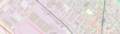 Quentinsville, by CartographerKing
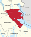 Map 1 / Location of Agawaskway
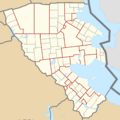 Map 2 / Municipalities of Agawaskway (obsolete)
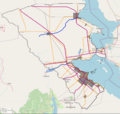 Map 3 / Transport of Agawaskway (obsolete)

