Collab:Malësoria: Difference between revisions

From OpenGeofiction
mNo edit summary
No edit summary
Line 1: Line 1:
'''UL17g''' is a territory in the southern part of [[Uletha]]. It is a very diverse country, both culturally and geographically, from the mountainous north, the quasi-steppe-like central areas to the mediterranean-like southeast.
'''Malësoria''', ''(OGF ID: UL17g)'', is a country in the southern part of [[Uletha]]. It is characterized with diverse ethnicities and cultures, various types of geographical features, and an unique mapping style.


It is a collaborative project run by [[User:JoJoBa]] as the coordinator. If you are interested, contact the aforementioned user [https://opengeofiction.net/message/new/JoJoBa here].
It is an open community collaborative project, meaning you can join at any time if you meet the following requirements for joining, set by the coordinator:
Direct link towards the map is [https://opengeofiction.net/#map=7/41.500/79.937 here].
*Have at least 50 changesets/edits
*Have an account at least 3 months old
*Have no history of rule-breaking activities


Current active mappers and people who have expressed interest in participating are: '''[[User:JoJoBa]]''', [[User:stjur]], [[User:Lithium|User:Lithium-Ion]], [[User:Rustem Pasha]], [[User:2amCereal]], [[User:Nikolia]], [[User:MiePrzKom]], [[User:KAB]], [[User:Sudo90]]...
The owner of the territory and the project coordinator is [[User:JoJoBa]]. If you are interested to join the project, feel free to contact the coordinator [https://opengeofiction.net/message/new/JoJoBa here].
By joining the project you agree to be active and consistent, whether is it small additions to the map or larger uploads.
The coordinator has every right to remove you from the project team, meaning you will need to request permission again if you are willing to join back. This will be done after 4 months of inactivity on your side. After being removed from the team, your edits would be counted as invalid and other members have the right to delete or modify your mapping without your permission.


= Resources =
For territory owners which border Malësoria, they are free to edit 5 km (3 mi) from the border line into Malësoria, if you are not a member of the project.
Below are all the resources that may help you with mapping in the territory, or teach you about the idea behind the country.


== Inspirations and ideas ==
Current project team:
The main inspiration is the country of Albania, alongside other areas, including:
*'''[[User:JoJoBa]]'''
*[[User:Lithium-Ion]]
*[[User:MiePrzKom]]
*[[User:Rustem Pasha]]
*[[User:stjur]]
*[[User:sudo90]]


: ''*In '''bold''' are the main sources of inspiration.''
== Rules ==
[[File:Malesoria Rules.png|center|500px]]


{|class='wikitable unsortable'
{| class="wikitable mw-collapsible mw-collapsed" style="width:70%; margin:0; margin-left: auto; margin-right: auto; border: none;"
! Area of inspiration
! Type
! Notes
! Area on OGF
! Area on OSM
|-
|-
| '''Albania'''
! style="background:#dddddd; color:#022fb5; text-align:center; height: 35px;" | Rules of the project (detailed overview)
| Cultural, linguistic & mapping-wise
| Most of the territory's mapping is inspired by either directly Albania or tweaked Albanian, both infrastructure, architecture and language. Neighboring countries may also be used as inspiration, mapping-wise.
| [https://opengeofiction.net/#map=9/41.2200/80.6699 OGF Map]
| [https://www.openstreetmap.org/#map=8/41.166/20.264 OSM Map]
|-
|-
| '''(South) Caucasus Region'''
| style="text-align:left; height: 50px;" |
| Geographical, cultural & mapping-wise
*The language you should use is '''Albanian'''. This applies to areas with other ethnicities as well.
| The north will be inspired by the countries of Azerbaijan and Georgia. The area would be an autonomous region, whose western part have Bulgarian minorities, while the eastern one would have Georgian minorities.
*'''Try not to divert from the style used in the country'''. - Mostly rural; Undeveloped; Sparsely populated.
| [https://opengeofiction.net/#map=9/43.1711/79.3130 OGF Map]
*Mapping set in historical time (e.g. 1500 AD) is not allowed, '''everything has to be set in modern times'''.
| [https://www.openstreetmap.org/#map=9/41.5641/46.0052 OSM Map]
*Due to the nature of 'community collaborative projects', '''all discussions have to be made via the Forums'''. ''This does not forbid you to discuss about the project off-site, but everything that is deemed official and affects the larger picture of the project has to be discussed on the forums.''
*'''Avoid lists off-site.''' Everything has to be documented here.
*'''All OGF rules apply to this project as well.'''
*'''Follow the plans from this page and the forums at all times!'''
|-
|-
| Western Mediterranean Region(s)
|}
| Geographical only
 
| Located in the littoral area of UL17g, the area would be a continuing of the mapping in southwestern [[Qennes]] and the northeastern [[Demirhan Empire]] area.
<gallery mode=packed>
| [https://opengeofiction.net/#map=10/39.7610/83.3011 OGF Map]
File:Malesoria Infr.png|thumb|
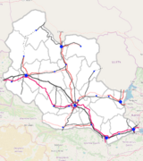
Plan for the nation-wide infrastructure of the country.
| [https://www.openstreetmap.org/#map=8/43.113/6.916 OSM Map]
File:Malesoria Geo.png|thumb|
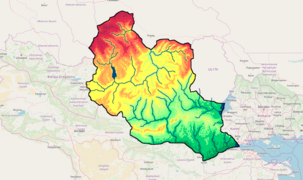
The geography of the country.
File:Malesoria Eth.png|thumb|
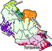
Ethnicities of the country. Light green and light purple are the two groups of Malësorians, Highland Malësorians and Lowland Malësorians respectivelly.
</gallery>
 
=== What can you map, and what not ===
[[File:Malesoria what to map.png|center|500px]]
{| class="wikitable mw-collapsible mw-collapsed" style="width:70%; margin:0; margin-left: auto; margin-right: auto; border: none;"
|-
|-
| Aquitaine / Occitanie
! style="background:#dddddd; color:#022fb5; text-align:center; height: 35px;" | What can you map, and what not (detailed overview)
| Geographical only
| Found in various areas throughout the country, notable for it's series of paralleling rivers and streams, with gentle rolling hills in between.
| [https://opengeofiction.net/#map=9/40.5326/80.5408 OGF Map]
| [https://www.openstreetmap.org/#map=11/43.4120/-0.0137 OSM Map]
|-
|-
| Moldavia (region) / Moldova (country) / Transnistria (region)
| style="text-align:left; height: 50px;" | You '''can''' map freely:
| Geographical only
*Rural areas; smaller towns - ''any village or smaller town in any part of the country. This includes both rough details (exclusively roads and landuse at a bare minimum) or detailing of any level.''
| Similar to the previous region of inspiration. Series of rugged, but rolling hills, but with a much lower amount of rivers.
*Natural features - ''both large scale and more detailed ones. This includes but is not limited to: woodlands, grasslands, wetlands, beaches, riverbanks, mountain peaks, caves, rivers, etc.''
| [https://opengeofiction.net/#map=9/39.9582/82.2079 OGF Map]
*Low-level infrastructure - ''local roads, rural roads up to primaries, railways, smaller airports, ferries, etc.''
| [https://www.openstreetmap.org/#map=9/47.0982/28.6880 OSM Map]
*Buildings in cities and towns with defined layout - ''If a city or town locality has a defined shape, layout and plan, feel free to edit .''
You '''can not''' map freely ''(i.e. you should discuss with the community about everything regarding these OR you should follow the plans when mapping these)'':
*Larger cities and towns which do NOT have a defined layout
*Larger scale infrastructure - ''highways and trunks, state-wide railways, major airports, etc.''
*Names and toponyms which are deemed important, and whose names should be discussed with the community.
*'''Mapping already made by other users.''' - ''Instead of changing it yourself, contact the user who made it to rework the area. Due to the project being early-stage currently, adding more mapping should be a priority instead of constantly changing existing mapping.''
|-
|-
| Niederbayern (Lower Bavaria)
|}
| Geographical only
 
| Similar to the previous two. Differences include: much flatter terrain & higher elevation.
 
| [https://opengeofiction.net/#map=9/41.7488/79.8926 OGF Map]
== Sources of inspiration ==
| [https://www.openstreetmap.org/#map=10/48.5712/12.2141 OSM Map]
[[File:Malesoria inspo.png|center|500px]]
 
{| class="wikitable mw-collapsible mw-collapsed" style="width:70%; margin:0; margin-left: auto; margin-right: auto; border: none;"
|-
|-
| [[Qennes]] / [[Demirhan Empire]]
! style="background:#dddddd; color:#022fb5; text-align:center; height: 35px;" | Sources of inspiration (brief overview)
| Geographical, cultural, linguistic and mapping-wise
| It will be a meeting point between the current mapped areas between the two mentioned countries, and inspiration should be taken from those two areas. Generally flat and urban.
| [https://opengeofiction.net/#map=11/39.5729/83.7426 OGF Map]
| N/A
|-
|-
| [[Suria]] - [[Antharia]] - [[Kartlegia]] Border
| style="text-align:left; height: 50px;" |  
| Geographical and cultural
The mapping environment in Malësoria should be rather unique. However, that doesn't mean you should not use real world examples as bases and inspiration. Some which we think may deem useful are (in '''bold''' are the main sources of inspiration):
| The mountains found in this area area a good reference for the mountains in north UL17g, it is wise to take them as inspiration.
*'''The entire country of Albania'''
| [https://opengeofiction.net/#map=9/41.5641/84.7540 OGF Map]
*'''The Caucasus region''' - for the northernmost areas of the country, with the border of Suria.
| N/A
*'''Environments of the surrounding territories''' (Demirhan Empire, Qennes, UL17h, Suria, White Dregovine) - for border areas
*Moldavia (in Romania) and Moldova - for the southwestern plains
*Transylvania (in Romania) - for the central highlands
*Dinaric Alps (in the Balkans) - for the southern mountain chain
*Danube - for the Kiran river (border with Demirhan Empire)
|-
|-
| [[White Dregovine]]
| Geographical, cultural, linguistic and mapping-wise
| The area is inhabited by the Lower Dregovinians and follows the same topography and landscape as the one of White Dregovine.
| [https://opengeofiction.net/#map=9/41.6195/76.7340 OGF Map]
| N/A
|-
| Kiran Valley / Kirmizi - Adanaz
| Geographical
| Inspired by the mountains and valleys in the [[Demirhan Empire]].
| [https://opengeofiction.net/#map=9/39.9498/78.8242 OGF Map]
| N/A
|-
| Iron Gates (Đerdap Gorge)
| Geographical
| A gorge inspired by the Iron Gates, but without a hydropower dam and a reservoir.
| [https://opengeofiction.net/#map=11/40.0912/80.9143 OGF Map]
| [https://www.openstreetmap.org/#map=11/44.6022/22.1011 OSM Map]
|}
|}


== Brief overview ==
== Propositions ==
[[File:PlanUL17g.png|thumb|Main sources of inspiration and basic picture. See table above.]]
[[File:Malesoria Nam.png|thumb|Features that are named by the community so far, or still are unnamed.]]
*UL17g is a semi-poor country inhabited primarily by the [unnamed] people group, inspired by the Albanians (currently unnamed). Their language is an isolate.
*Country name:
*There are various minorities including the Qennesans in the southeast, Turquese in the southeast and south, Dregovinians in the west, OGF:Bulgarians in the northwest, Kartlegians in the northeast and east, and Antharians in the east.
**'''Malësoria''' - [[User:MiePrzKom]]
*It is a country of large diversity in geography, featuring many types of landscapes, from snowy mountains and alpine mountains, to mediterranean coasts, and even pockets of sand dunes.
**Tonënia - [[User:Rustem Pasha]]
*It includes many places of natural beauty and unique terrain shapes and formations, ready to be put on the map.
**Atdhe kugurëzohet [[User:Lithium-Ion]]
 
*It is an highly unequal country economically. The capital city, its near surrounding, Lake Tirdau area and the southeast region are much wealthier compared to most of the rest of the country, especially the far north featuring a very low income population.
*Its economy is composed of manufacturing, mining and other industries primarily, as well as agriculture. Tourism is present in low amounts, but is growing rapidly.
 
*It is politically in a difficult position, pressured from both Demirhan and Suria, along with its many ethnicities lurking with their nationalistic movements. It is considered as highly corrupt.
*It is a country of a high and rapidly growing but also emigrating population, especially to the nearby countries like Qennes and Antharia, but also Plevia, Franqueterre and Gobrassanya.
 
*It is located on a crossroad area between West and Central Uletha, home to the historical, but also the modern OGF:Silk Road.
**Its infrastructure is incredibly advanced on a larger scale. The highways are well maintained and numerous (proportional to the country size), following the OGF:Silk Road. Same goes for transcontinental railways. Ferries are quite prominent on the Kiran River. Rest of the infrastructurial aspects are still considerably low.
 
*It is a majorly [[Irfan]] nation, at about 55%, followed by [[Iviran]] at 19% and [[Christic]] at 12%, with the rest being various or non-religious.
 
=== Mapping style ===
*The mapping style should follow the Albanian one in most of the areas, especially the urban one.
*There may be Soviet-style quarters in the northern areas.
*Cities should be dense, especially in the central/old town area. Many of them may feature fortresses, castles and other historical features.
**Villages should be dense and numerous, dotted in the densely populated areas, but strictly following the geography.
*Despite the low economy of the country, there won't be much slums, however they may be at least some.
*A lot of farms should be present in the rural and flatter/moderately hiller areas. Woodlands shall be located in the mountainous areas. Snowy peaks only in the north areas. Other natural features and their occurrence  is varying.
 
== Rules for joining ==
The only requirement is to have at least 3 month of mapping activity on your profile. Using JOSM instead of iD / Potlatch 2 is highly recommended, but not necessary.
:If you are owning a neighboring territory, but not part of the collaboration project, you are free to edit 5km into the border with UL17g.


It is not required, but it is highly recommended to use Discord for easier communication. For joining the unofficial OGF Discord server, contact [[User:JoJoBa]].
*Capital city name:
**'''Tëlrasan''' - [[User:MiePrzKom]]
**Vogës - [[User:JoJoBa]]


=== What to map, and what not? ===
*Name of the autonomous region:
[[File:InfrastructureUL17g.png|thumb|The basic infrastructure of UL17g. Pink - motorways; Light red - Trunk; Very light red - Trunk under construction; Gray (Bold) - railways (main branch); Grey - railways; Gray (Dotted) - Railways under construction/disused.]]
**'''''Tonënia''''' - [[User:Rustem Pasha]] - ''reused from the country names proposition list''
[[File:CultureUL17g.png|thumb|The ethnicities in UL17g.]]
Language wise, you should map:
*'''...in Albanian, but not strictly following the language's rules. Albanian is a hard language, and there are no confirmed Albanian mappers on OpenGeofiction, so you are able to be flexible with the language. As in:'''
**Small grammatical errors are tolerated, as they can't be evaded in some situations.
**Feel free to tweak the language as you please, as long as it is reasonable and as long as it is kept within words and not whole sentences. ''Remember to add your words/translations to the table below so other mappers can use them as well.
**Avoid known places in Albania, you may use much lesser known ones, but try making up your own toponyms and names, as an unique language, that shouldn't be too hard :)
**You can avoid special characters such as Ç and Ë if you are not able to use them all the time, you can replace them with 'c' and 'e', but are encouraged to use the digraphs 'dh', 'gj', 'll', 'rr', 'sh', 'th', 'xh' and 'zh'.
**Areas with minorities may or may not use dual names and toponyms. The names may or may not be in OGF:Albanian, but there should be a visible influence for the respective minority in the name, if true.
*If you are familiar with any minority languages, you can map the areas where they are present.


[[File:TopoUL17g.png|thumb|The geography of UL17g.|left]]
*Names of the mountain ranges:
**''Add proposals here...''


'''Please follow the global plan at all times!!!'''
*Names of the main cities:
**City '''C1''' - Portat e Arta ''(Golden Gate (al))'' - [[User:Rustem Pasha]]
**City '''C2''' - Vogës - [[User:JoJoBa]] ''(reused from the capital city names proposition list)''
**City '''C3''' - Tekinhane Veriore ''(Northern Sanctuary (tr/al))'' - [[User:Rustem Pasha]]
**City '''C4''' - Bicajzë - [[User:MiePrzKom]]
**City '''C5''' - n/a
**City '''C6''' - Aibashjamvë ''(originally Aibaŝamwa)'' - [[User:Sudo90]]


Mapping wise, you '''should''' map:
*Names of the main lakes:
*Rural areas, villages, small and medium sized towns. Larger towns should be discussed with other members, but are not disallowed to be mapped individually.
**'''Liqeni i Bashelezit''' - [[User:MiePrzKom]]
*Natural features, all of them.
*Details: buildings, fields, shops, etc. Have fun with those!
*Lower-level infrastructure - local roads, and roads up to primaries, local railways, smaller airports, ferries etc.


...however, try '''not''' to map the following without a thorough discussion with the rest of the project members:
*Higher-level infrastructure - highways/trunks, cross-national railways, international airports, the port in [https://opengeofiction.net/#map=13/39.6044/83.7620 (unnamed) city], etc.
*The capital city, which will be planned between all project members.
*Names and toponyms of the most prominent features (largest cities, capital city, tallest peaks, longest rivers, largest lakes, etc.).
*Use official names not discussed and made official, such as the country's name, unnamed toponyms, etc.
 
*'''Replacements of other people's mapping. Try to be tolerant and instead of deleting other peoples' work, try to be constructive and contact them to repair any mistakes.'''
 
==Propositions==
 
[[File:NamingUL17g.png|thumb|Primary features to be named collectively by the project members. A-F - Mountain ranges; R1-R4 - Main rivers; C1-C6 - 6 main cities; CAPITAL - Self-explanatory; L1 - Lake.]]
 
Write your naming proposals below:
 
*'''Country name''':
**Malësoria (MiePrzKom)
**Tonënia (Rustem Pasha)
**Atdhe (Lithium-Ion) kugurëzohet
 
*'''Capital''':
**Tëlrasan (MiePrzKom)
**Vogës (JoJoBa)
 
*'''Autonomous region''':
 
*'''Mountain ranges''':
 
*'''Rivers''':
 
*'''Main cities''':
**Aibaŝamwa for the city near Surian border (C6) -- [[User:Sudo90|Sudo90]] ([[User talk:Sudo90|talk]]) 14:52, 16 May 2021 (CEST)
**Bicajzë (C4 | [https://opengeofiction.net/node/227700825] | MiePrzKom)
**Tekinhane Veriore (broken Turkish/Albanian: ''Northern Sanctuary'' | C3 | [https://opengeofiction.net/#map=12/39.2362/82.2061] | Rustem Pasha)
**Portat e Arta (''Golden Gate'', coincidence with Arta unintended | C1 | [https://opengeofiction.net/#map=12/39.5890/83.7156] | Rustem Pasha)
*'''Lake L1''':
**Liqeni i Bashelezit (MiePrzKom)
 
== Language ==
Below is a list of words and phrases that may be useful while mapping:
 
Try putting words following the alphabetical order of the English section! Always expand the table when the limit has been hit!
 
{|class='wikitable sortable'
! English
! Conlang/Albanian
|-
|
|
|-
|
|
|-
|
|
|-
|
|
|-
|
|
|-
|
|
|-
|
|
|-
|
|
|-
|
|
|-
|
|
|-
|}


== Companies & businesses ==
[[Collab:Malësoria/Lists]]


[[Category:Malësoria]]
[[Category:Official collaborative projects]]
[[Category:Official collaborative projects]]
[[Category:Uletha]]

Revision as of 15:01, 18 September 2021

Malësoria, (OGF ID: UL17g), is a country in the southern part of Uletha. It is characterized with diverse ethnicities and cultures, various types of geographical features, and an unique mapping style.

It is an open community collaborative project, meaning you can join at any time if you meet the following requirements for joining, set by the coordinator:

  • Have at least 50 changesets/edits
  • Have an account at least 3 months old
  • Have no history of rule-breaking activities

The owner of the territory and the project coordinator is User:JoJoBa. If you are interested to join the project, feel free to contact the coordinator here. By joining the project you agree to be active and consistent, whether is it small additions to the map or larger uploads. The coordinator has every right to remove you from the project team, meaning you will need to request permission again if you are willing to join back. This will be done after 4 months of inactivity on your side. After being removed from the team, your edits would be counted as invalid and other members have the right to delete or modify your mapping without your permission.

For territory owners which border Malësoria, they are free to edit 5 km (3 mi) from the border line into Malësoria, if you are not a member of the project.

Current project team:

Rules

Malesoria Rules.png
Rules of the project (detailed overview)
  • The language you should use is Albanian. This applies to areas with other ethnicities as well.
  • Try not to divert from the style used in the country. - Mostly rural; Undeveloped; Sparsely populated.
  • Mapping set in historical time (e.g. 1500 AD) is not allowed, everything has to be set in modern times.
  • Due to the nature of 'community collaborative projects', all discussions have to be made via the Forums. This does not forbid you to discuss about the project off-site, but everything that is deemed official and affects the larger picture of the project has to be discussed on the forums.
  • Avoid lists off-site. Everything has to be documented here.
  • All OGF rules apply to this project as well.
  • Follow the plans from this page and the forums at all times!

What can you map, and what not

Malesoria what to map.png
What can you map, and what not (detailed overview)
You can map freely:
  • Rural areas; smaller towns - any village or smaller town in any part of the country. This includes both rough details (exclusively roads and landuse at a bare minimum) or detailing of any level.
  • Natural features - both large scale and more detailed ones. This includes but is not limited to: woodlands, grasslands, wetlands, beaches, riverbanks, mountain peaks, caves, rivers, etc.
  • Low-level infrastructure - local roads, rural roads up to primaries, railways, smaller airports, ferries, etc.
  • Buildings in cities and towns with defined layout - If a city or town locality has a defined shape, layout and plan, feel free to edit .

You can not map freely (i.e. you should discuss with the community about everything regarding these OR you should follow the plans when mapping these):

  • Larger cities and towns which do NOT have a defined layout
  • Larger scale infrastructure - highways and trunks, state-wide railways, major airports, etc.
  • Names and toponyms which are deemed important, and whose names should be discussed with the community.
  • Mapping already made by other users. - Instead of changing it yourself, contact the user who made it to rework the area. Due to the project being early-stage currently, adding more mapping should be a priority instead of constantly changing existing mapping.


Sources of inspiration

Malesoria inspo.png
Sources of inspiration (brief overview)

The mapping environment in Malësoria should be rather unique. However, that doesn't mean you should not use real world examples as bases and inspiration. Some which we think may deem useful are (in bold are the main sources of inspiration):

  • The entire country of Albania
  • The Caucasus region - for the northernmost areas of the country, with the border of Suria.
  • Environments of the surrounding territories (Demirhan Empire, Qennes, UL17h, Suria, White Dregovine) - for border areas
  • Moldavia (in Romania) and Moldova - for the southwestern plains
  • Transylvania (in Romania) - for the central highlands
  • Dinaric Alps (in the Balkans) - for the southern mountain chain
  • Danube - for the Kiran river (border with Demirhan Empire)

Propositions

Features that are named by the community so far, or still are unnamed.
  • Name of the autonomous region:
  • Names of the mountain ranges:
    • Add proposals here...
  • Names of the main cities:

Collab:Malësoria/Lists