...sh). Another is inspired by Nordic/Germanic languages but diverges from RW languages more than the others.
...it just seems too different from the others (both in Kara and in this area of East Uletha) to really make sense in this spot. What do you think? Should I
2 KB (367 words) - 21:28, 8 October 2022
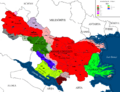
 | File:East uletha culture proposal.png Own work based on the SVG map template created by User:Timboh.
...resents the cultures/languages of countries that '''currently exist on the map''', whereas the lighter shade represents the '''proposed culture for curren
(2,710 × 1,770 (1.38 MB)) - 16:32, 27 June 2022 |
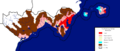
...ue territory etiquette|free to edit blue]] country, mapped in '''Dravidian languages''': [[wikipedia:Kannada|Kannada]] and [[wikipedia:Tamil language|Tamil]].
...re are many existing uses of other languages, due to the past edit history of the territory. These should be renamed as appropriate
1,012 bytes (132 words) - 00:33, 17 January 2022
*** STATIC MAP
*** LANGUAGES
9 KB (1,206 words) - 14:49, 22 December 2021
| style="width: 12em; vertical-align:top;" | [[File:{{{flag}}}|150px|Flag of {{PAGENAME}}]]
...e of the [[File:2560px-FP-Deodeca.svg|28px|border]] [[Deodeca|Commonwealth of Deodeca]]''</div>
3 KB (390 words) - 19:57, 30 October 2023
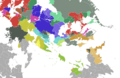
...ap in the same style as the [[OpenGeofiction:Territories#Overview_Map|main map]], but with the countries coloured by language. I think this would make it
: The territory overview map already indicates the main language for each of the blue territories, using the "edit" arrows. For every other territory it
1 KB (166 words) - 20:20, 4 July 2023
*** LOCATION MAP
--><tr><td style=width:40%;"><b>Constituent state of</b></td><td><b>{{Federal States}}</b></td></tr><!--
9 KB (1,193 words) - 14:28, 6 November 2021
*** FLAG AND COAT OF ARMS
-->[[File:{{{image_coat}}}|85px|alt={{{alt_coat|Coat of arms}}}]]</td>|}}<!--
9 KB (1,271 words) - 13:28, 16 July 2022
...here is "non-canon" - it doesn't really exist for the purposes of the rest of the OGF world.
...Territories have defined themes and languages, and mappers are expected to map to those there. However, within this zone there are no theme constraints.
1 KB (207 words) - 12:52, 25 November 2022
<!-- Start of left-column -->
== Cultures and languages of West Uletha ==
2 KB (212 words) - 17:19, 29 February 2024
...re are many existing uses of other languages, due to the past edit history of the territory. These should be renamed as appropriate
All users can map in AR923.
894 bytes (115 words) - 00:19, 17 January 2022
|coords_zoom = 4<!-- The zoom coords /#map=THIS/xx.xx/xx.xx?layers=x -->
|coords_lat = -51.625<!-- The y coords /#map=x/THIS/xx.xx?layers=x -->
5 KB (794 words) - 03:52, 2 December 2023
| style="width: 12em; vertical-align:top;" | [[File:{{{flag}}}|150px|Flag of {{PAGENAME}}]]
...e [[File:Flag_of_the_FSA.svg|28px|border]] [[Federal States|Federal States of Archanta]]''</div>
3 KB (338 words) - 19:53, 30 October 2023
|languages = Norlensk, Lechian, Jiemiesillimigiella, Johksvardian, Läxic.
...at internal borders to promote the exchange of products, the free movement of people and trade in the Arctic region. It is the only relevant intergovernm
4 KB (495 words) - 16:24, 12 June 2023
...shaped around the XX Bay like an inverted lowercase a, aswell as a number of small islands and exclaves.
|coords_zoom = 8 <!-- The zoom coords /#map=THIS/xx.xx/xx.xx?layers=x -->
6 KB (1,044 words) - 03:58, 2 December 2023
<!-- Expert user? change one bit of text and then use the pencil icon to switch to Source Editing -->
'''Name:'''青天民国(Republic of Ching Tien)
6 KB (903 words) - 17:14, 2 July 2022
<!-- Expert user? change one bit of text and then use the pencil icon to switch to Source Editing -->
...more industrial. There would be lots of transport infrastructure, and the map's environment/mapping style would be similar to places like the UK, Austria
3 KB (404 words) - 11:03, 20 November 2023
...your languages or colangs? And if so, are you using derivations for naming map features (e.g. olympic-size swimming pool)?<br> --[[User:Aiki|Aiki]] ([[Use
...Irenic already existing, I opted for conserving the original /eː/ instead of the more "recent" /i/ so that ''erenic/érénique/erénico/erenisch'' may b
2 KB (252 words) - 16:29, 12 August 2023