Collab talk:Huaxia
|
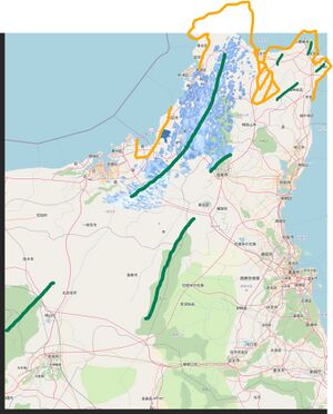
关于华夏东北部海角省海岸线等较大地理变更的讨论
Discussion on the significant coastline and other geo-feature change of Haijiao Peninsula in Northeastern Huaxia
在本页面以外的讨论 Discussion out of this page
| 北京时间2024年9月20日下午2时许我私聊了快乐的老鼠宝宝,其大致表示同意,但他亦认为这是在赤道地区,「山可能还是有点多了」;我和他讨论了是否有不大量添加山区的可能性,其表示可以「城市化」,「霓虹那种」「关东平原」,但因OGF上不应过度城市化,且即使是关东平原,其南部(千叶县南部)也有一定支撑,且城市化也无法改变地理结构,我不赞成此想法,并提出搁置。 | At around 2 p.m. on September 20, 2024, I privately messaged Happy Mouse Baby, who roughly agreed but also remarked that this is an equatorial region, where "there might be too many mountains." I discussed the possibility of not adding too many mountainous areas with him, and he suggested "urbanization," "like Tokyo," or the "Kanto Plain." However, since OGF should not be over-urbanized and even the Kanto Plain has some support in its southern part (e.g., Chiba Prefecture), and urbanization cannot alter the underlying geography, I disagreed with this idea and suggested shelving it. |
All contents above are by NM$l (talk) 09:17, 22 September 2024 (UTC)
讨论 Discussion
| 我认为,主要需要讨论的点为:①此更改是否必要;②如必要,此更改是否合理。 | In my opinion, the main points that need to be discussed are: (1) whether this change is necessary; and (2) whether the change is reasonable, if necessary. |
| 啥语言都行。 | Any language |
All contents above are by NM$l (talk) 09:35, 22 September 2024 (UTC)
| 自本讨论发布以来截止目前未在本页面收到回应,且华夏各成员表示无异议;经站内信邀请Wangi检查后已获同意,此项变更将在更细致地规划、绘制后上传至服务器。 | Approved and will be mapped after a more detailed planning. |
All contents above are by NM$l (talk) 15:45, 4 October 2024 (UTC)
华夏铁路路徽征集与投选
Vote on the icon of Huaxia Railway
华夏铁路总公司是华夏主要的铁路运营企业,前身为华夏铁道部,现向广大Mapper征求铁路路徽设计(普速铁路、高速铁路样式各一款),期望如下:
|
The Huaxia Railways Corporation is the primary railway operator in Huaxia. Formerly the Ministry of Railways of Huaxia, it is now seeking emblem designs from the Mapper community for its railway system (one design each for conventional and high-speed railways). The requirements are as follows:
| |
| 提示:路徽将出现在包括但不限于以下场景:车票、车站站房和其他铁路建筑、铁路机辆和车厢等。 | Tip: The emblem of HR would like be on the: rail tickets, railway buildings, railway locomotives and carriages, etc. | |
| 欢迎您在下方留下您的设计,请为表格添加一行,在第一列插入图片,第二列写出希望参加投票的赛道,第三列填写一些解释说明,并最后一列添加「~~~~」,其将会在您提交时自动转为签名和时间戳(若因故需要通过User:NM$l代传图片者,将留下不带链接的OGF用户名)。 | You are welcomed to leave your design. Please add a new row in the following table. |
| 编号 | 提案 | 分野 | 说明 | 提案人/签名 |
|---|---|---|---|---|
| 1 |  |
高速铁道 | 快捷、高效、通达、现代、舒适;
简明的标识使其在不同的使用场景下,包括移动设备和电脑的屏幕上都有较高的可识别性; 可去掉文字标直接作为标识,适用于app、导视、背景、视效等多种场景。 |
Z Empty (talk) 09:05, 23 November 2024 (UTC) |
| 2 |  |
普速铁道 | 凸显历史(注:标识标准色为黑色和铁道绿);
两条横线似两条铁道,交织连结,通达四方,标识比例类似一节车厢,横线托承字标,意为火车的运输功能,服务可靠; 彩色使用时代表华夏的H保持黑色/白色不变,H的黑白取决于使用场景的背景色; 去掉文字标使用时托承文字标的线条缩短。 |
Z Empty (talk) 09:05, 23 November 2024 (UTC) |
| 3 |  |
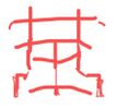
混合 | 基于“華”字变形,结合铁道和蒸气机车头形象,既像華夏的華,又似火車的車;
整体无文字标,方正比例在不同大小下都可识别,亦适合网络和移动设备场景下的使用; 规整方正。 |
Z Empty (talk) 09:05, 23 November 2024 (UTC) |
| 4 |  |
混合 | 启发于民国时期或更早期的路徽。 | saigyoujinoriko |
| 5 |  |
混合 | HR的字母变形;
H是向远方无限延伸的铁轨; R左半边为铁路路签, 右半边为路签接收装置。 |
Yongdinghe (talk) 09:19, 23 November 2024 (UTC) |
| 6 |  |
混合 | 瞎画的,主体是一个繁体华字,我想把它画成火车头的形状。 | 114514aaa (talk) 15:53, 22 November 2024 (UTC) |
| 7 |  |
普速铁道 | 此LOGO是以中文“华”字为基础,通过变形设计形成的图案,展现了中华文化的深厚底蕴与现代铁路产业的高速发展。红色的主体色调象征着热情与活力,同时也代表了铁路事业的红火与蓬勃发展。图案中向外延展的线条如同铁路轨道般延伸,寓意着四通八达的交通网络和公司开放进取的精神。此外,整体设计简洁大气,传递出华夏铁路公司高效、安全、可靠的品牌形象。 | Masyas |
| 8 |  |
高速铁道 | 此LOGO以“HXHR”为核心标识,结合“华夏高铁”的汉字表达,突出了华夏高速铁路品牌的名称与内涵。图案右侧由红、蓝两条流畅的弧形线条构成,象征着高速铁路飞驰的轨迹。红色代表激情与进取,蓝色则寓意科技与稳定,二者融合展现了华夏高铁追求卓越与创新的精神。
整体设计具有现代感和动感,传递出高速铁路的速度感与技术力量,同时也体现了华夏高铁作为交通枢纽连接四方、服务大众的重要使命。LOGO简洁鲜明,便于识别与传播,是华夏高速铁路品牌形象的直观体现。 |
Masyas |
| 9 |  |
混合 | 参照CR和朝鲜铁道省,外形形似机车头,圆形部分形似人,排障板形似民,下部亦似道钉。 | NM$l (talk) 09:02, 23 November 2024 (UTC) |
| 10 |  |
混合 | 参考CR路徽,上半部分类似机车头,也可视作一个变形的“人”字,下半部分既形似分岔的铁道,又可看作是“人”的另一种变形,体现“人人为我,我为人人”“人民铁路为人民”的精神,同时象征华夏铁路通向全国各地。 | Yongdinghe (talk) 08:31, 24 November 2024 (UTC) |
投票和决定 Vote & Decision
| 经协调员确认,决定本次征集截稿于2024年12月1日,并随后进行投票。华夏绘图者之拥有OGF wiki账户者于此处投票,其余人员于群组内投票,不可双平台重复投票。
每人可对高速铁路和普速铁路路徽各投一票,二者分别计票,票高者胜。为尽可能不浪费各位来稿人心血,其余徽标可以被考虑用作它用,如铁路集团公司标志等。 |
After confirmation by the coordinators, the deadline for this submission has been set for December 1, 2024, after which voting will take place. Huaxia Mappers with OGF wiki accounts can vote on the platform, while others can vote within the designated group. Double voting across both platforms is strictly prohibited.
Each person may cast one vote for the high-speed railway emblem and one for the conventional railway emblem, with the votes counted separately. The design with the highest votes in each category will win. To make the most of the contributors' efforts, other submissions may be considered for alternative uses, such as the emblem for the Railway Group Corporation or similar purposes. |
| 截至2024年12月1日0时,已收到上述10份稿件,此10份稿件由该列表从上至下编号1~10,华夏绘图者之拥有OGF wiki账户者于下方投票,可同时对高速铁路或普速铁路路徽投相同的稿件,但不可投类型不匹配的徽标;其余用户通过此链接于问卷星平台投票,投票截止时间取华夏多数活跃成员完成投票或2025年1月1日之早者。
对具有华夏活跃成员的定义为,截止到2024年12月1日,在过去的2个月(指10、11月这2个自然月)内,在华夏境内做出编辑的,且超过10笔的,且没有被举报破坏的,视为在这个时间点具有了投票资格。其实鼠宝觉得也没必要学wikipedia社区写这么完善,但是已经变成严谨的民选了,那就顺势完成定义吧。然后抓人我会挨个去手工看有没有资格。 补充,突然意识到似乎还没有规定什么是多数,这里钦点为超过50%就算多数,懒得折腾。剩下的50%没投的,世界大喇叭不用到点作废。然后华夏成员(不管活跃不活跃)依照在osmwiki注册了的为准,具体名单可见合作者名录。 |
As of 0:00 on December 1, 2024, the above 10 manuscripts have been received. These 10 manuscripts are numbered 1~10 from top to bottom in this list. |
投票 Voting
| 主会场(本页面)投票 Votes here | 问卷截止时问卷星分会场开票 Votes on Wenjuanxing (For not-wiki mapper) | ||||||||||||||||||||||||||||||||||||||||||||||||||||||||||||||||||||||||||||||||||||||||||||||||||||||||
「普速铁路」路徽投票
「高速铁路」路徽投票 |
截止12月8日13:00,问卷星分会场收到下列用户名投票:
注:「(跳过)」指在问卷中选择「有wiki账户」而触发限制无法投票。 |
计票 Counting
最终决定于12月8日13:00截止投票,计票如下:
| 方案 Propodal | 1 | 2 | 3 | 4 | 5 | 6 | 7 | 8 | 9 | 10 | 结果 Results |
|---|---|---|---|---|---|---|---|---|---|---|---|
| 普速铁路路徽得票 For nor service | X | 2 | 2 | 0 | 0 | 0 | 6 | X | 0 | 2 | Winner No.7 号当选 |
| 高速铁路路徽得票 For HSR service | 4 | X | 0 | 0 | 0 | 0 | X | 7 | 0 | 1 | Winner No.8 号当选 |
注:「X」表示提案和分野不匹配。

