Forum:Ingrea/Wendon
Wendon is the capital and largest city of Ingrea, located in the country's eastern region. Below users can discuss the development of various aspects of the city including infrastructure, nature, placement of buildings and amenities, history, etc. Users are free to add a section to this page (under the section Discussions) every time they'd like to discuss a particular topic using the appropriate heading format.
Interested users are free to contribute, though it is worthy to add your name to the list of participants below before commencing with any editing.
List of participants
Add yourself to the bottom of the list using the automatic signature template: * ~~~~
- ── Bixelkoven (talk) (West Uletha Admin) 15:22, 13 March 2026 (UTC)
- Xoxasochka (talk) 15:51, 13 March 2026 (UTC)
- Sudo91 (talk) 16:22, 13 March 2026 (UTC)
- Myrcia (talk) 19:40, 13 March 2026 (UTC)
- --Aces California (talk) 20:06, 13 March 2026 (UTC)
- Yuanls (talk) 20:46, 16 March 2026 (UTC)
- Mantan (talk) 21:41, 17 March 2026 (UTC)
- AR FKU (talk) 19:21, 23 March 2026 (UTC)
- Jr000 (talk) 00:32, 24 March 2026 (UTC)
- BMSOUZA (talk) 20:07, 25 March 2026 (UTC)
- Qhfreddy (talk) 16:34, 31 March 2026 (UTC)
Initial mapping
As a kickstarter, User:Sudo91's layout proposal was voted and approved, and subsequently uploaded to the map. This mapping is more of a guide for future development than a finalized setup. From here, users are welcome to discuss the city's growth and map the city working with the current layout. Users are free to beautify the existing mapping, as well as add onto it. Consult the active user base on this page first before doing any major changes.
Additionally, the rest of the Wendon province features mapping from other users. Including Charford,Charlingchester,New Haethersmith, Northgate and Wirrenham. This mapping is mostly of low-detail, so reworking it is allowed, although users wishing to do so are also suggested to contact the users who created the mapping in the first place.
No map areas
The small area of Mickle Iction should NOT be edited by any users whatsoever. It is considered as a holy site and its destiny within Wendon's province is uncertain. It may or may not be moved elsewhere, users may work around it, but not directly in or by it. Its status can also be discussed.
Plans and map guides
Please consult the following gallery of images for the city plans. More images will be added in the future.
-
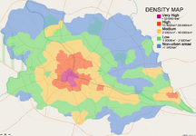 Density
 -
 Landuse


-
 Image 1: Population density guideline
 -
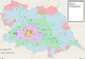 Image 2: City landuse and points of interest
Discussions
Hi, friends! BMSOUZA here. As I also like collaborative projects, and I did some thing in Castellan, Plevia, Kalkara and Naphon, I would like to participate here too. Could I get permission to edit Wirrenham, from the Ring Road III to the current mapped area? I think I provided good examples from my edits in collaborative projects in OGF... Have a nice weekend, friends! -- BMSOUZA (talk) 14:33, 14 March 2026 (UTC)
- Adding a bit more info: My initial ideas are, maybe moving the urban core closer to the "north" rails, and to create a road access from the Ring Road and the "south" one. Farmlands around it. Urban area not more than 30k population. Maybe one industry, or distribution center, something like it. I would keep the stadium too, just moving to a better place. -- BMSOUZA (talk) 14:40, 14 March 2026 (UTC)
- Great idea, I'd like permission to map some housing complexes from the 70s. Xoxasochka (talk) 15:13, 14 March 2026 (UTC)
Sudo, could you clarify what all the symbols you've put alongside underground stations and the like mean? Primarily the ∯, ∇, and ⁅≏⁆ symbols? I feel like starting with a Railway Terminus and would like to know what I'd need to connect to. :P --Aces California (talk) 14:25, 16 March 2026 (UTC)
- Okay, I think I got an understanding on this, the usages are tagged on what lines are laid I believe?
- ∯ is the Wendon Subsurface Railway (what I presume is equivalent to the Underground?)
- ∇ is the Municipal Underground (which I presume is equivalent to the Overground?)
- ⁅≏⁆ is the Wendon Diffgrade (which I presume is equivalent to the Elizabeth Line/Crossrail?)
- Let me know if this is the correct interpretation of these tags? --Aces California (talk) 19:19, 26 March 2026 (UTC)
- ∯ Subsurface Railway -- old underground, 1863, OGF:Metropolitan/District/Circle line
- ⁅≏⁆ Different Grade Railway (Diffgrade) -- old underground, 1891, OGF:"deep tube"
- ∇ Municipal Underground Railway -- new underground, 1959, OGF:Victoria/Jubilee line
- ≜ Riverside Samegrade -- suburban rapid transit line, 1970s, think DLR x Croydon trams
- ℕℝ National Rail -- long-distance, 1840s
- ℞ Vicinity Railways -- suburban rail, 1840s
- ℍ㏛ High-speed Rail -- HSR, 1985
- (Reposted from Sudo91 on Discord) Yuanls (talk) 22:58, 31 March 2026 (UTC)
I also have a question, in terms of the motorways, Can I map them as dual carriageways instead of single carriageways and is there any restrictions in what we can map? AR FKU (talk) 19:32, 23 March 2026 (UTC)
- To answer this and other questions regarding permissions (BMSOUZA's, Xoxasochka's and AR_FKU's questions): as stated at the top of the page, interested users are free to contribute, therefore you all have permission to map what you requested, since those are changes not changing the grand scope of the city. For things like "I'd like to move the main castle/railway station...", "I want to make the river wider/thinner by a lot...", or similar, it is better to notify the active user base here, and if there's no opposition after a few days/a week, commence the edits. This should also be the case increasingly as the city is mapped more, because moving existing high-quality mapping is bothersome, and should be done with the permission of other users, including the user who made the mapping. At the current stage when there's minimal high-detail mapping, users are generally welcome to map almost anything in order to get the 'mapping snowball' rolling. ── Bixelkoven (talk) (West Uletha Admin) 22:14, 23 March 2026 (UTC)
- I have an additional question which is what is the numbering system for the roads like? Because I did use general UK numbering systems as in Motorways being M67 for example and primary roads being A roads, I've had a few complaints about it, would it be an issue or do I have the go ahead for that? AR FKU (talk) 22:20, 26 March 2026 (UTC)
- I'm of the opinion that we should hold off road numbering (and to junction numbering, to an extent) until we establish a national system. It doesn't really add any substance to the mapping, and numbering roads will only cause confusion if everybody invents their own system. Yuanls (talk) 15:53, 27 March 2026 (UTC)
Hi, friends! I am currently editing Wirrenham town area, and if I got good results, maybe I will start one or two (small) towns later. Any feedback, I will be happy to read. But, talking about Wendon area, I think I can be useful creating sports area if and where you all decide. As an old-school OGF user, I think I am able to detail areas like these. We can decide how much football and rugby teams, where exactly they are, etc. BMSOUZA (talk) 02:49, 28 March 2026 (UTC)
Similarities and differences to London, UK
Hi all, I'm planning to make a start on mapping in Wendon soon. Does anybody have any suggestions on how the city could differ from London? We have the geographical layout and historical development outlined in Sudo91's proposal, but how could the overall character of the city change from a mapping point of view? One point which I previously highlighted was that Wendon has a more developed motorway and trunk road system than London, similar to what the London Ringways project had originally envisioned. Perhaps this makes for a less extensive (or even retrogressed) public transport system? Yuanls (talk) 00:17, 28 March 2026 (UTC)
- Hello, this is a minor change but we could keep most of the old part of Wendon without any high rises, similar to what happened in Paris with their height restrictions in the central arrondissements, leaving the high rises and commercial center to another area (maybe south of the river to not deviate too much from Sudo's proposal). Jr000 (talk) 00:55, 28 March 2026 (UTC)
Points for consideration with existing draft
Hi all, I'm interested in contributing in the area, also had some discussions on the Discord with other mappers re: the existing layout. Here are some of the points I'd like to raise for discussion before too much mapping gets done and these features get locked in. I'm not particularly partial to whether the features should stay or not, however I think it may be worth "justifying" their existence or building some history to base them on, for other mappers to work with.
- "very old settlement" area. Does this location make sense with respect to natural geography? My intuition is that the location may be too flood prone and thus suboptimal for a very old settlement to be located. My understanding is that the settlement of London during Roman times and through the middle ages was set back from the river somewhat. It may also be worth considering that London was burned down by fires many times over history so buildings from that era are generally only preserved as archeological remains underground. Would it make sense to maybe have an "archeological park" located somewhere further north-west of that location?
- Rail infrastructure. In general I think we should hold some discussion of the layout of the rail network around the city, this will require some thinking about Ingrea as a whole, namely on the points of what routes were established earliest, where would be the most important traffic corridors, and how/where would the terminus stations be located within the city, potential cross city corridors and through stations. Unfortunately a lot of Ingrea is inactive territories nowadays, so anything done in this regard may constrain mappers looking to apply for those territories. Some thoughts on the existing mapping in particular: I think the current locations are a bit too far from the city centre, particularly on the north side. I am not a fan of the rail tunnel under the Royal Grounds, I don't think there is really a sensible way to justify such a thing, I had some concurrence of views on this point from another mapper. I am not sold on the HSR bypass in the east, this may be something that is better to revisit when the original network is more fleshed out. An idea I had was that if we were to go with a more elaborate wall system (see points below) for the city, maybe the parks and walls could have been used in some way as space for building the railways?
- City Walls. Somewhat related to the first point, I feel like if we are going with an elaborate and well preserved system of city walls, it may be good to discuss the history of the defences in more detail. My understanding is that London's city walls did not have as much military significance by even the Middle Ages, and that during Roman times the walls were set primarily to the north to defend against attacks from tribes(?) in that direction, with the Thames later being an avenue of attack for Vikings. How does the north/south dynamics fit in for Ingrea? Was it more aligned with Nordic territories to the north, or the continental Ulethan cultures to the south. This will obviously tie in significantly to other territories and lore in the region, but there should be some room to discuss it nonetheless.
- City development over time. The map above showing the extent of the city by century I undersand is a draft, can we discuss fleshing this out a bit more, particularly as pertains to the ca. 16th century city core? I think this will have a major impact on many of the other features to be mapped later, so it is worth spending some time developing a concensus to work with. The currently mapped area is significantly larger than the populated area of London at that time period. I'm not an expert on historical mapping or historical cities so it's not exactly easy for me to judge how to interpret those kinds of historical maps, however I do think it may be worth scaling down the city core somewhat, this will also tie in to other infrastructure such as the rail termini.
Look forward to hearing other people's views on these points, and anything else people think is worth raising, maybe it is worth creating subheaders for each of these points to branch out the discussions. Regards Qhfreddy (talk) 16:34, 31 March 2026 (UTC)
- I can make some comments on rail infrastructure for now:
Re: Termini positioning: I agree that it would make sense to move the two northwestern railway termini futher inwards, perhaps to the northern side of the reservoir at Rosewall. I've always found the position of the rail terminus opposite Parliament Hill rather strange - perhaps it should be cut back to terminate at the northwestern side of the Royal Residences. The rest of the route could be replaced by an underground line?
Re: terminus development: The modern significance of London rail termini doesn't entirely tie to their historical development. The history of rail in London, which spans almost two centuries, is complicated by a whole array of factors, including geography and economics, and includes a substantial (and even dominant) commuter and freight component along side long-distance travel. I'm inclined to let people map semi-freely, and apply lore retroactively for this.
Re: HSR: I agree, and I too have found its positioning slightly disconcerting. I'm of the opinion that, given the population density of the Ingrean east coast, any HSR line(s) would be likelier E-W oriented. Lines to Claedon, or the Winburgh area seem most probable. Yuanls (talk) 22:58, 31 March 2026 (UTC)