Paroy

|
Republic of Paroy  République du Paroy (Valonian) |
Loading map... |
Paroy (/pərɔɪ/), officially the Republic of ParoyÎ (Valonian: République du Paroy), is a federal republic in the southern part of Tarephia, in the northwest of the Budrian Peninsula, where it connects to the Tarephian mainland. The country is composed of 11 states and a federal district in which the capital and largest city, Coleraine, is located. Other major metropoles include Trevers, Sainte-Hélène, Bluemond and Emison. Paroy is moderately populated, with nearly 35 million inhabitants taking up the country's area of 394,181 km2. The country is relatively urbanised with most large metropoles along both the west and northeast coast. Furthermore, the country is bordered by Freedemia in the south and southeast, Dania in the northeast and Miramar in the east. The most common languages spoken are Ingerish and Valonian. Paroy is a member of the Ingerish Commonwealth, the Tarephia Cooperation Council and the Assembly of Nations.
Etymology
Although a variety of theories exist about its name, it is believed the name Paroy is derived from the Pannarangoyi word parraoia, which roughly translates to 'bulging lands'. This most likely refers to the hilly coastlines near Panaca. The name was first mentioned on a world map of Gonnar Machuni in 1578 as Para Oya, near what is now Panaca. The name was later used by Ingerish immigrants and as the colony expanded, the name would be used more often, and eventually became Paroy or Paroi. Only in the end of the 17th century the name was used as an unofficial name for the entire territory, in the time still officially named the Veronan Colonies. Another theory explains that the name comes from the Valonian pays du royaume, referring to the lands beloning to the Valonian empire.
History
Indigenous folks
Ulethan colonisation
Pretanese colonisation and the Nouvelle-Valonne
In the early 13th century, several Pretanese expeditions took place around what is now the Northwestern Paroyan Coast. A few settlements from this time remain, but due to the rough terrain in the area and the large distance from Pretany, the first Valonian colony on Paroyan ground made a slow start. But in the next century, the region was expanded rapidly and many settlements were established. Sainte-Hélène, eventually one of the largest Valonian settlements in Paroy, was established in 1327 and served as the administrative capital for the Colombe province of the Nouvelle-Valonne.
During the 15th century, the Nouvelle-Valonne started expanding on Paroyan soil. The Colombe province spread out to what is now Linton and a new province, Madison, much larger than the current state, was established in the northeast of Paroy. In 1465, Cauvigne (now Coleraine) was founded and became an important port on the Gulf of Madison for trade with Latina City and later Cordoba.
Ingerish colonisation and the Veronan Colonies
While the area of the Nouvelle-Valonne now covered almost half of the Paroyan Republic today, Ingerish expeditions explored the Paroyan west coast, and eventually started settlements in around what is today Panaca. It is believed that the first Ingerish settlement on Paroyan ground was Rosefield in March 1545. The Ingerish colony spread fast around the Veronan coast, chartering Summerton and Templeton in 1546, Melwick and Weston (today West Trevers) in 1547 and Ansley in 1551.
In 1572, the Verona Colony was established with as main purpose the transportation of goods like crystals, gold, oil, lumber and tropical fruits and spices to Ingrea and other colonies like Freedemia. Later, more and more people came to live in the newfound colony, expanding and creating more settlements and eventually more colonies. In 1595, the Trevers Colony was found by splitting of from Verona, because of the high concentration of settlements and fast growing population around the Ansy river. A few years later, these settlements were combined as the City of Trevers, creating a new economic center on the west side of Paroy.
After a short period with a lot of immigrants coming to the different colonies, the different colonies were grouped together as the Veronan Colonies in 1612. At first it served as a self-governing colony, but got the status of Dominion in 1656.
Colonial wars
Paroyan Revolt and Independence
Following the Ingerish Civil War in the 1710s, and the loosening grip of Metropolitan Ingrea on it’s colonies, many of them were forced to survive on their own. Between 1720 and 1728, many of Ingrea’s colonies like Vodeo declared their independence, mostly with success.
With the Ingerish Civil War over and the loss of many of its colonies as a result, the monarchy did everything to thwart these former colonies by discontinuing trade to them from its remaining territories. Because of new trade agreements between the Veronan Colonies and the now-independent Tarephian and Antarephian colonies and the continuation of trade of Ingerish goods to these countries, the Veronan Colonies received heavy penalties from Ingrea. This led to a steep drop in the economy of the Colonies. Lots of people lost their jobs because of the disappointing revenue from the trade, leaving many in poverty or homeless.
By February 1729, the financial crisis escalated in the Paroyan Revolt against the presence of the Ingerish government in the Colonies. A few months later, the Veronan Colonies officially declared war to Ingrea. Some harbours were destroyed, like the Port of Summerton. During the Revolt in 1731, the First Anarchistic Revolution broke out. Towns and cities were plundered, government buildings like the Governor Palace in Trevers, were destroyed and set on fire and people – mostly Ingerish officials and their families – were brutally murdered in the streets and in their homes.
In 1733, just a few days before independence, the parts of the Crystal City and docks of Trevers were set on fire by the Royal Navy. Around 8.500 people died and many buildings, including most of the western docks, were devastated. This Great Trevers Fire led to the last battle in ![]() Matthews Bay, on January 31. With the Royal Navy already massively outnumbered, they finally surrendered on February 2. Exactly a week later, the Declaration of Independence for Paroy was signed.
Matthews Bay, on January 31. With the Royal Navy already massively outnumbered, they finally surrendered on February 2. Exactly a week later, the Declaration of Independence for Paroy was signed.
Confederation and Trade League
Unification and anarchy
Modern era
Geography and environment
 | |
|---|---|
| Geography of Paroy | |
| Continent | Tarephia |
| Region | Lycene |
| Population | 31,942,260 (2020) |
| Area | |
| • Total | 394,181 km2 152,194 sq mi |
| • Water (%) | 11.6% |
| Population density | 81 km2 209.8 sq mi |
| Major rivers | Ansy, Louvagne, Nissony, Loraine, Coleraine |
| Time zone | Budrian Standard Time (WUT+2) |

Paroy is in Southern Tarpehia, located on the northern end of the Lycene Peninsula, which it shares with Freedemia, Meilan, Miramar and Beldrio. It is also bordering Dania on the north-east. The country is connected to bodies of water on two sides of the country. Paroy lies mostly between latitudes 12° and 20°S, and longitudes 26° and 33°E. Paroy covers 394,181 km2 (152,194 sq mi), consisting for 11.6% of water.
The landscape in Paroy varies wildly, with mountains and tropical rainforests in the east and south-east, mountain ranges in the north, and hills in the west and centre of the country. Paroy can therefore be subdivided in 5 geographic regions: the Coasts (West and East Coasts), the Northern Peaks (north), the Valleys (Andoras, centre), the Forests (east) and the Plains (centre/south). Dense rainforests take up 37% of the country, making it hard to settle down in most of Dorges, Radigan and Magali. Large parts of these rainforests are protected in national parks. Because of this, most of the country's population lives on the west coast and the north-east where land consists of rolling hills varying with some higher mountains and flat lands. Landuse in Paroy is very diverse. The inner land contains landscapes with wineries and farmlands, while the higher areas on the coast and the east feature more mining. At 2,160 metres Mount Lorrez is the highest mountain in Paroy.
The most important rivers in the country are the Ansy, Louvagne, Nissony, Loraine, Vale, Coleraine, Kareusse and Callabon. Paroy also features serveral lakes in various places in the country.
- Landscapes in Paroy
-
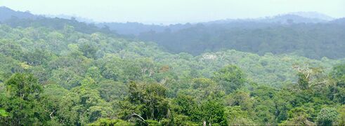 Rainforest in southern Dorges
 -
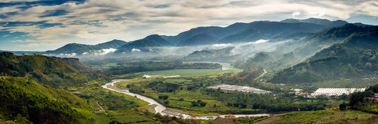 Hilly landscape in Southern Andora
 -
 Rouvience Mountains in Columbus
 -
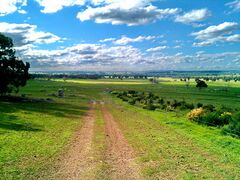 Grassy plains in inland Verona
 -
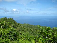
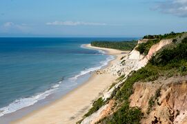 Beach in north-western Verona


Climate
| ||||||||||||||||||||||||||||||||||||||||||||||||||||||||||||||||||||||||||||||||||||||||||||||||||||||||||||||||
Paroy's climate is predominantly tropical, heavily influenced by its latitudinal position between 12° and 20°S and its extensive coastline along the western and northeastern shores. The country exhibits a diverse range of microclimates, from humid tropical rainforests to more temperate coastal zones, largely shaped by altitude, proximity to the sea, and varied topography.
The prevailing climate types include tropical rainforest Af and Am, particularly dominant in the eastern and southeastern regions, encompassing much of Dorges, Radigan, and Magali, where dense rainforests flourish. These areas experience consistently high temperatures and abundant rainfall throughout the year, with a tendency towards monsoonal patterns in some localities (Am) and potentially drier periods (As or Aw) in others, especially at the transition zones to other climate types.
Coastal areas, especially along the extensive western seaboard, benefit from significant oceanic moderation. Cities such as Trevers, located on the Lycene Peninsula's western coast, exemplify this influence. Trevers experiences warm to hot summers and mild winters, with rainfall distributed throughout the year, though slightly diminishing during the cooler months. The average monthly temperatures in Trevers range from a low of 8.3°C (46.9°F) in July to a high of 32.9°C (91.2°F) in December. Rainfall in Trevers averages around 100 mm (3.9 inches) per month, peaking in the early summer. This coastal moderation extends inland in some areas, contributing to humid subtropical Cfa, and even Csa and Csb climates.
Further inland, especially in the central and northern regions, the elevated terrain gives rise to areas experiencing temperate highland climates Cfb, characterized by cooler temperatures and distinct seasons compared to the low-lying tropical zones. The capital, Coleraine, situated at the confluence of a large river and the northeastern sea, experiences a warmer climate than Trevers, indicative of the lesser moderating influence of the northeastern coastal waters and its specific geographical setting.
Rainfall is generally high across Paroy, particularly in the eastern rainforests. While a distinct wet and dry season is not universally pronounced, coastal areas and some inland regions experience a reduction in precipitation during the cooler months. The country's topography, with its mountains in the east and north, also influences rainfall distribution, creating localized rain shadows and areas of enhanced orographic precipitation.
Extreme weather events are infrequent in Paroy. While the country's tropical latitude places it within a potential cyclonic zone, destructive hurricanes or tornadoes are rare, typically occurring only once every century.
Nature
Paroy's diverse landscapes and varied climate zones foster an exceptionally rich biodiversity, making it a significant ecological hotspot on the Lycene Peninsula. The country's natural heritage is broadly characterized by its extensive tropical rainforests, unique coastal ecosystems, and a variety of habitats found within its mountainous and hilly regions.
The dense rainforests of the east and southeast, particularly within the Dorges, Radigan, and Magali regions, represent a prime example of Paroy's untouched wilderness. These ancient forests are home to a staggering array of flora, including towering Veridian Palms (Palma viridiana), known for their iridescent green fronds and resilient wood, and the elusive Glimmerbloom Orchid (Orchis lucens), a nocturnal flower that emits a soft bioluminescent glow. The understory thrives with unique fungal species and a variety of ferns, creating a complex and interconnected ecosystem.
Fauna in these rainforests includes a high degree of endemism. Among the most notable is the Azure Drifter (Ales caerulea), a large, brilliantly plumed bird-of-paradise species, famous for its elaborate courtship displays. Smaller, yet equally fascinating, is the Whisperwing Bat (Chiroptera murmurans), a specialized fruit bat with an exceptionally quiet flight, crucial for seed dispersal. Large predators include the Shadow Leopard (Panthera umbratica), a melanistic feline adapted for stealth in the dense canopy, and the River Serpent (Hydrus fluviatilis), a semi-aquatic constrictor found in the Louvagne and Nissony river systems.
Coastal and western regions, influenced by the more moderate climate, host different ecological communities. The Crimson Heath (Erica rubra), a hardy shrub with vibrant red blossoms, dominates some of the drier coastal hills, while the Silverleaf Fig (Ficus argentea) is common in the riparian zones near the Ansy and Coleraine rivers, its leaves adapted to reflect sunlight. Marine ecosystems off the western coast are vibrant, supporting diverse fish populations and unique coral formations, including the rare Fan Coral of Lycene (Corallium lycenensis). The intertidal zones are critical nesting grounds for various sea turtles.
The mountainous areas, including the slopes of Mount Lorrez and the Northern Peaks, feature sub-alpine and montane forests, characterized by species adapted to cooler temperatures and higher altitudes. Here, the Stonebark Fir (Abies petrosa), a coniferous tree with exceptionally tough bark, is prevalent. Unique to these elevations is the Cloud Heron (Ardea nubes), a large, cryptic bird that feeds in mist-shrouded valleys and high-altitude streams.
Preservation and heritage
Significant efforts are underway to conserve Paroy's rich natural heritage. The Paroyan Wildlife & Habitat Authority (PWHA; Autorité Paroyenne de la Faune Sauvage et de l'Habitat, APFSH), a governmental body, oversees the management of national parks and protected areas, ensuring the preservation of critical ecosystems. Complementing their work, the Lycene Peninsula Conservation Trust (LPCT; Fiducie de Conservation de la Péninsule Lycène, FCPL), a prominent non-governmental organization, actively engages in reforestation projects, community-based conservation initiatives, and research into endemic species, working to safeguard the country's unique biodiversity for future generations.
Government and Politics
Economy
Demographics
| Demographics of Paroy | |||||||||||||||||||||||||||||||
|---|---|---|---|---|---|---|---|---|---|---|---|---|---|---|---|---|---|---|---|---|---|---|---|---|---|---|---|---|---|---|---|
| Demonym | Paroyan | ||||||||||||||||||||||||||||||
| Official languages | Ingerish, Valonian | ||||||||||||||||||||||||||||||
| Recognized minority languages | Paleke, Pannarangoyi, Budrian | ||||||||||||||||||||||||||||||
Ethnicities | |||||||||||||||||||||||||||||||
| |||||||||||||||||||||||||||||||
Religion | |||||||||||||||||||||||||||||||
| |||||||||||||||||||||||||||||||
| Literacy | |||||||||||||||||||||||||||||||
| Life expectancy | |||||||||||||||||||||||||||||||
Urban areas
| № | City | State | Population | Description |
|---|---|---|---|---|
| 1 | Coleraine | Federal Capital District∈⊾ƨ | 4,835,690 | |
| 2 | Trevers | Verona∈⊾ƨ | 3,717,157 | |
| 3 | Sainte-Hélène | Montrey∈⊾ƨ | 1,683,181 | |
| 4 | Panaca | Verona∈⊾ƨ | 972,714 | |
| 5 | Bluemond | Andora∈⊾ƨ | 934,894 | |
| 6 | TBD | Magali∈⊾ƨ | 825,712 | |
| 7 | Emison | Winnett∈⊾ƨ | 732,636 | |
| 8 | Riley | Nissony∈⊾ƨ | 605,804 | |
| 9 | Sansbury | Andora∈⊾ƨ | 517,991 | |
| 10 | Glendale | Andora∈⊾ƨ | 502,264 |
| № | City | State | Population |
|---|---|---|---|
| 1 | Coleraine Capital Metropolitan Area | FCD, Madison, Radigan | ~11,200,000 |
| 2 | Trevers-Ansley-Gracey Metro Area | Verona, Nissony | ~8,900,000 |
| 3 | Sainte-Hélène-Louvagny Metro Area | Montrey | ~5,200,000 |
| 4 | Panaca-West Verona Metro Area | Verona | ~3,300,000 |
| 5 | Bluemond Metropolitan Area | Andora | ~2,600,000 |
| 6 | Emison Metropolitan Area | Winnett, Andora, Verona | ~1,900,000 |
| 7 | Magali Capital Metro Area | Magali | ~1,400,000 |