Ardencia
 This encyclopedia article is about the country of Ardencia. You may be looking for the collaboration page.

|
Ardencia  |
Loading map... |
Ardencia (Ardence in Valonian) is a federal republic located in South Archanta. The country spans ...km2 (... sq mi), making Ardencia one of the largest countries in the world in terms of land area. It is a sparsely inhabited country of 26 million people with a mid-sized economy.
Its capital is Saint Armand wich is also largest city of the country. Ardencia is composed of 12 Provinces in wich Valonian is the official language, even if Ingrean is also spoken in some of them.
Indigenous peoples have continuously inhabited the territory for thousands of years and their culture remains present throughout the country..
Etymology
Ardencia takes its name from the Ardentic Ocean that washes the country’s long eastern coast.
Geography
Location and borders

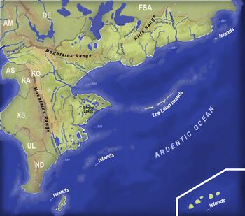
Ardencia is a transcontinental country located in South Archanta. The vast majority of the country’s territory and population is situated on its mainland. One part of Ardencia, the province of Seganak, is located on the Island of Owanko (map)∈ shared with Neo Delta and six archipelagos partake to the territory as well:
- 01 Isles Blanches [1]
- 02 Katinga Islands (Katinngajut-Qikiqtaq) [2]
- 03 Kawanga Islands (Kawanngajut-Qikiqtaq) [3]
- 04 Lillians Islands [4]
- 05 Isle of New Surricy [5]
- 06 Western Islands [6]
Extreme points:
North: On the Sainte Rose River, along the Federal State border [7]
South: At ... Cape, Duke Brown Island [8]
East: On ... Island, Lilian Islands [9]
West: On .... Island, Isles Blanches [10]
In longitude, the country spans ....km (...mi) from 126.46°E in Cap to 158.88°E the River. In Latitude, Ardencia stretches ...km (...mi) from the 42nd Parallel ([11]) to the 54th Parallel ([12]), considering the mainland only.
It is bordered in the west by the Asperic Ocean and the Ardentic Ocean in east.
Its land borders consist of Ambrosia, Deodeca and the Federal States of Archanta to the north, the Astrasian Confederation to the east and Neo Delta in the south. In the northwest, the border with Ambrosia is delineated by the Mattappi River∈⊾, the Missanappi∈⊾, and the Condor Massif. The Condor Massif then draws the border with Deodeca until it departs from the drainage divide by turning north into a landscape of hills and glacial lakes. The border with the Federal States is defined by natural features, parallels and meridians. The main feature along this border are two of the Great Lakes: Lake Minnehunkou∈⊾ and Lake Wihinapa∈⊾ located in the western section of border. The border with the Astrasian Confederation is mainly marked by two rivers: the Takaou and the Deleuze Rivers. Mostly due to its extensive archipelagos, Ardencia possesses an Exclusive economic zone covering more than 3,000,000km2.
Geology, topography and hydrography

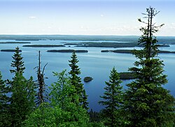
Ardencia has a wide variety of topographical sets and natural landscapes. Large parts of the southern Provinces sit on a geological shield that was heavily eroded during Glacial Ages. Though it generally features poor soils improper for agriculture, the Ardencian Shield underground is filled with substantial deposits of mineral ores. This region is heavily covered by coniferous forests. Central and Eastern Ardencia are dominated by large plains drained by powerful rivers such as the Horrakan or the Hanyala. These fertile silt beds are extensively used for agriculture, mainly cereal fields. Northern Ardencia, generally hillier, is dominated by the Great Lakes system.
|
Loading map... |
High mountains are mainly located along the central sections of both sets of borders. The Condor Range Mountains are an old eroded range that underwent an uplift when the east and west side sides of Southern Astrasia collided, generating the Titans Range Mountains. This collision created a series of parallel foldings in Central Ardencia between these mountain ranges, isolated Western Ardencia from the rest of the country. Thanks to many low-altitude gaps, various communication routes have developed between both regions.
At 2,494m (8,182 ft) above sea level, Mount Abc, located on the border with Deodeca is the highest point in the Condor Range Mountains.
The Titans Range Mountains, with their classic alpine profile, are usually split into five separate groups due to the large valleys isolating them.
|
Loading map... |
The long East Coast (over 4,100km) offers contrasting landscapes: rocky and lined with glacial lakes in the extreme south, flat and sandy, with sometimes extensive lagoons in the centre. North of the large Royal Bay, the coast is dotted with roadsteads offering many havens. The souskoutian Coast consists mostly of alluvial plains, former islands with some klippes left off the coast. The straight line of this flat coast is interrupted by a series of large estuaries, most of them being hardly navigable due to silting.
Climate
The climate of Ardencia is pretty cold, above all in the South with heath, forest and snow capped mountains. Its western part is wet and mild and its eastern coast is known to be windy. In the north, beyond the Mountains Range the climate is more continental with warm summers.
Administrative divisions
12 Provinces form the first-level of subdivision of the Ardencian Federation. Each province is vested with autonomous powers exercised by a provincial parliament and government. Per tradition, the Provinces have maintained representative offices to the Federation in Saint-Armand.
Each Province is further divided into Departments from their Valonian name départements. And each Department is composed of Counties (Comtés) Each provincial capital is located in a territory called Municipality (Municipalité).
| Province | Code | Capital | Largest city | Departments | Area km2 [1] | Population | Language |
|---|---|---|---|---|---|---|---|
| New Surricy (map)∈⊾fr: Nouvelle-Surricy | NS | Port St-Herbert | Port St-Herbert | 02 | 66,511∈⊾ | 420 000 | Valonian |
| Kawananga (map)∈⊾ | KA | Wakanda | Port-Espoir | 05 | 350 000 | Valonian, Ingerish | |
| Souskoutee (map)∈⊾fr: Souskoutie | SO | La Nouvelle-Andarion | La Nouvelle-Andarion | 05 | 4 260 400 | Valonian | |
| Seganak (map)∈⊾fr: Séganak | SE | Tannahawok | Tannahawok | 02 | 170 000 | Valonian, Ingerish | |
| Wohayatais (map)∈⊾fr: Ooayatais | OO | TBD | TBD | 07 | 71,983∈⊾ | 2 560 600 | Valonian, Ingerish |
| Sakardia (map)∈⊾ | SK | Meehelsa | Meehelsa | 07 | 68,351∈⊾ | 5 680 500 | Valonian, Ingerish |
| Wendogan (map)∈⊾ | WE | Saint Armand fr: Saint-Armand |
Saint Armand | 02 | 20,397∈⊾ | 3 560 400 | Valonian, Ingerish |
| Ewasia (map)∈⊾fr: Éwasie / Éouasie | EW | Grande Seigneurie | Larignon | 08 | 72,719∈⊾ | 2 350 200 | Valonian |
| Triaquia (map)∈⊾ fr: Triaquie |
TR | Belmont | Belmont | 05 | 95,848∈⊾ | 2 740 800 | Valonian, Native |
| Onkanam (map)∈⊾ | ON | Dobranska | Dobranska | 06 | 38,574∈⊾ | 1 250 000 | Valonian, Veltic, Native |
| Honneska (map)∈⊾ including
Katinga & Kawanga Islands and the Austral Territory of Isles Blanches |
HO | Saint-Julien | Saint-Julien | 03 | 71,400∈⊾ | 380 400 | Valonian, Native |
| Lillians Islands (map)∈⊾ (Wakanac Islands) fr: Archipel des Lilianes |
LI | Andréville | Andréville | 04 | 480 600 | Valonian, Native | |
| Total | 858,611 | 24 303 800 | |||||
History
Inhabited by different native groups (Hachallaggans, Triaks, Ewas, Kowanas, Chayans, Sakardians, Rakhodas, Haïdes)
Explored and colonised by the Valonian from the Asperic Ocean from the 16th century.
The Valonian Asperia disputed on its northern border by the Ingrean
Independance of Ardencia and the creation of the Ardencian Dominion in 1864.
Secession with the Astrasian Confederation
Creation of the Ardencian Federation
Massive veltic immigration
Relationship with the Federal State
Relationship with the Deodeca
Relationship with the Ambrosia
Politics
Government
Law
Foreign relations
Military
|
Loading map... |
Armed Defence of Ardencia falls within the sole competence of the Federal Authorities: Parliament and Government. The Ardencian Armed Forces (fr: Forces Armées Ardenciennes) comprise three branches: The Ardencian Army (fr: Armée Ardencienne), The Ardencian Navy (fr: Marine Ardencienne) and The Ardencian Air Forces (fr: Forces Aériennes Ardenciennes ). The largest and possibly most renowned military academy for the Army is the Special Military School of Saint Armand∈⊾.
Economy
Transport
Roads
Ardencia is a well developed country with huge road system
Roads are segregated into:
A-class motorways
N-class national priority roads
Local roads
The biggest amount of motorways can be found around Saint-Armand.
Trains
Each city is connected by a railway network that cross the whole country.
Airports
Demographics
Languages
Valonian is spoken everywhere in the country but Ingerish and Veltic are spoken in different provinces.
Valonian (75%), Ingerish (10%), Veltic (6%), native (6%), others (2%)
Education
Health
Culture
National flag

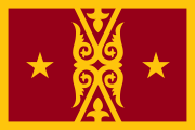
The national flag of Ardencia is one and a half times wider than its height (i.e. in the proportion 2:3). It depicts, on two carmine and gold strips, a traditional bird symbol of Native Peoples of Ardencia and a constellation of stars. This last one represents a part of the constellation of Orion seen from the southern hemisphere.
The bird surrounded by a gold circle symbolise the sense of freedom, community and wisdom for the Native people Federations. Gold symbolizes the wealth of the soil. Red symbolizes the blood of those who fought for their rights and for their freedom.
| Symbol | Image |
|---|---|
| National colours | Carmine - #960018
Mikado Yellow - #fec50c
|
- ↑ Including internal waters. As some Provinces are endowed with extensive lake networks, their actual land area may be smaller.