

Forum:Territory application/AN147B - Kefleshi (Exchange from Masjajo)
- Please fill in the information below to make a territory request.
 | Territory ID and proposed name |
|---|---|
| The Territory ID (from OpenGeofiction:Territories, e.g. AR123a) and proposed name of the country |
AN147B- Kefleshi
Exchange Masjajo (AN142c∈⊾ƨ) For AN147b∈⊾ƨ
I wanted to have a territory that is colder,has more coastline. and found it more suitable to the mapping style that i seem to like.
 | Physical geography |
|---|---|
| An overview of climate, topography and landscape of the country. With the exception of Beginner territories, you should always create a sketch map to illustrate & explain your plans. You can add a link to this (hosted on imgBB, Postimages or similar, but not imgur.com) |
Country is Pretty Flat Except The Hilly Far East
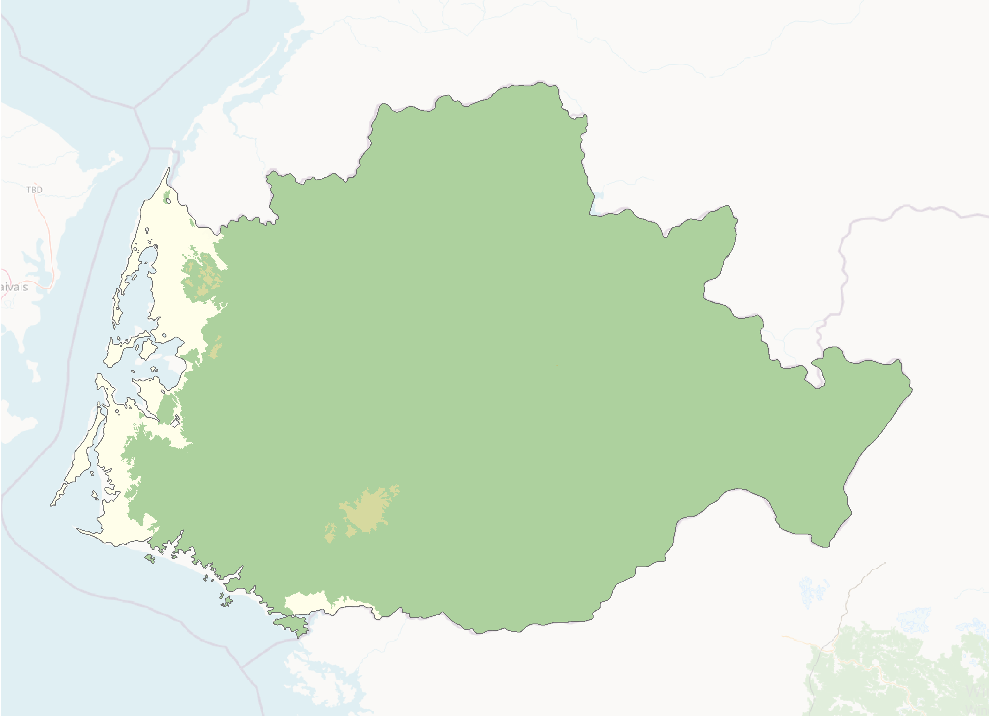
Forest map, can change - https://ibb.co/60N2nWSY
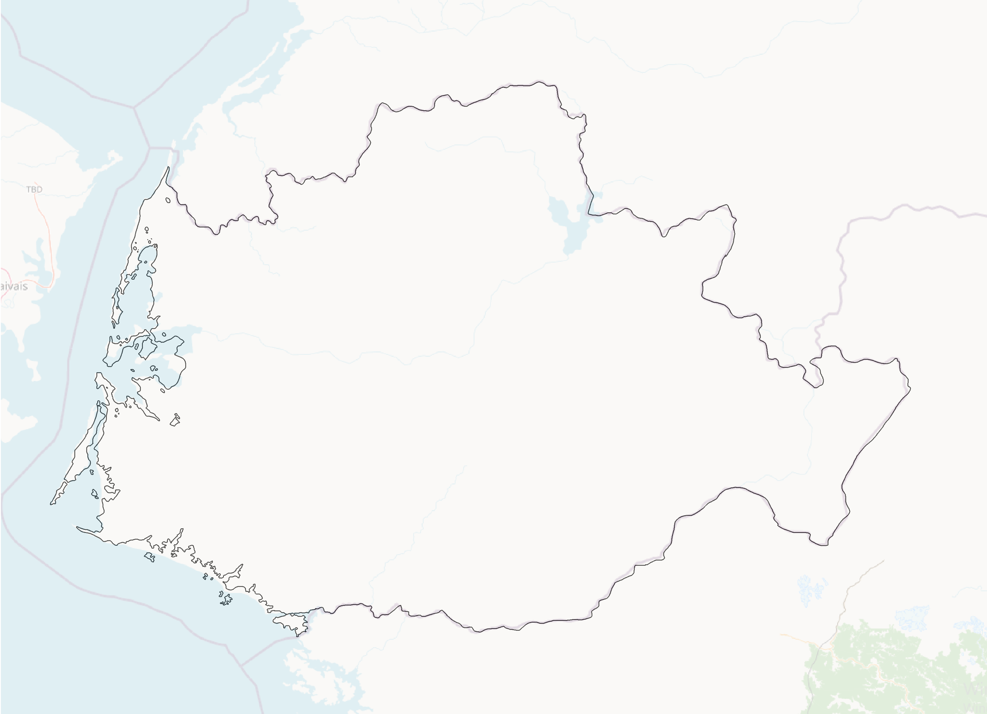
Coastline Change Sketch - https://ibb.co/W4DLLJY2
Its climate is pretty dreary,cold and wet especially in the coast, it has marshes,swamps in the coastal areas while inner areas are Foresty(Mostly Decidous Forests or Taiga) bogs also can be found in inner areas.
The Western Coasts Are Temperate Oceanic(Cfb), Inner Areas Can Be Continental Subartic(Dfc) And Subarctic Oceanic(Cfc)
 | Human geography |
|---|---|
| A brief description of the territory demographics, economic development, land occupation, infrastructure and mapping style |
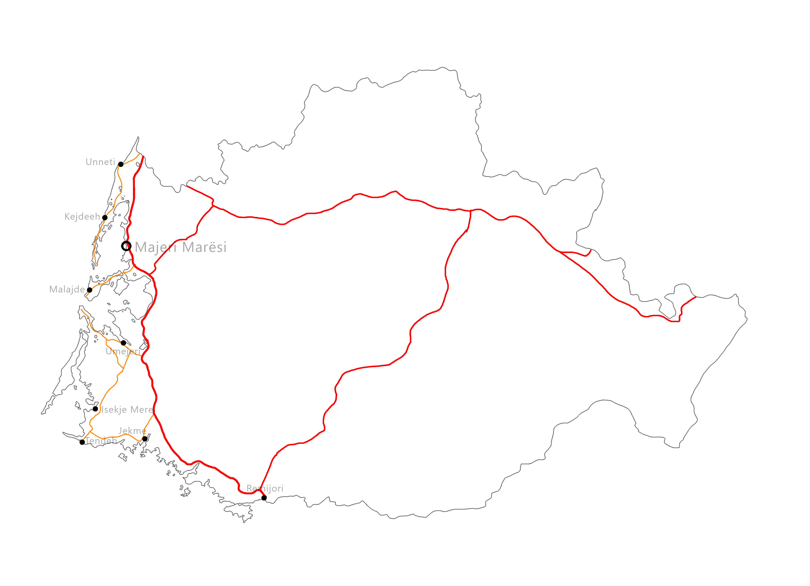
https://ibb.co/PsDZ8VPy cities map
Population: around 1-2 million
Gdp per capita: 45k
Economy is highly developed it mainly relies on fishing and services sector.
Most people live in the coastal cities and not much in inland areas,most of the country is made of forests except for coastal areas where there is mostly farming and fishing going on.
Cities are mostly planned grid cities, Preferred Mapping Styles Are Tasmanian/Southern New Zealand,Cascadian and Primarily Patagonian.
There is also a Major Roadway that runs through the most Populated Areas - https://ibb.co/1GGmjYG6
 | History & culture |
|---|---|
| A brief description of the intended culture and language |
The Country mostly speaks the native Language, Kefleshan, it was a former Ingerish Protectorate, because of that Ingerish Influence can be found.
The languages origin belongs to Sjepar Language Family
 | Past mapping |
|---|---|
| To support your request provide links to areas of OGF mapping which showcase your mapping skill. Mapping relevant to the requested theme & geography is especially useful. | |
| The {{coord}}, {{node}}, {{relation}} or {{scalehelper}} templates can optionally be used to link to the OGF map - they result in nicely formatted links. Or you can paste in a URL. |
Sulajo  46.81228°S, 47.38498°E
Lutasmajo 46.83736°S, 46.68164°E
Okiltaje, small island 46.93573°S, 47.21364°E
Landuse mapping 47.0608°S, 47.6117°E
Landuse And Town Mapping 45.39544°S, 48.48498°E
| Username & date |
|---|---|
| Sign and date the application by typing four tildes (~~~~) without spaces or "nowiki" tags. |
Migga (talk) 16:41, 21 October 2026 (UTC)
 | Discussion |
|---|---|
| Discussion for clarification & decision |
- Hey there, I was a bit surprised to see another territory application in the region so closely, moreso when it was a transfer request. As a nearby mapper, I have several points I'd like to hear your clarification on regarding the overall development of the region.
- Firstly, I would like to hear your thoughts on how to keep the topography and the coastline coherent, in particular a more detailed explanation of your intentions as far as topography. While there is no current owner of AN152e∈⊾ƨ, I think it would be nice to establish a template for the topography and geological features between our territories that ties the whole region together sensibly, including Wesman's territory. In particular, I mapped the north-west coast of Itarnar with a line of ~800-1000m fells along with fjords close to the coast, and had this slowly descend into planes going further north-east. I had a dormant proposal for the Large South Antarephian Lake to drain eastwards (File:Large-SA-Lake Proposal-2026-oct.PNG), with most of the topography of the "mid-antarephian gap" mentioned in OpenGeofiction:Antarephia#Geography being limited to a few bands of coastal hills along the west. I believe having some hills would better support your proposed new coastline, with its many inlets and bays, it may also be sensible to place the population centres further east where the climate is less influenced by the wind (I put very little farmland on the west coast as I believe the cloud cover would mean too little sunlight). I would also reference New Zealand, Tasmania, Chilean Patagonia, and the BC/Alaska coast, many of the settlements are not on the west-facing coast, but rather in sheltered places further east.
- On the topic of climate, I had previously discussed adjusting the climate page found on OpenGeofiction:Antarephia to better account for summer and winter variations in wind. Namely that during the winter, the wind should be biased more to come out of the north, while in the summer more from the south-west. This would mean the territories in our region would have pretty cool and somewhat drier winters. I'm not sure whether you expect this would have much impact on your plans for the territory, but I think it would be nice to possibly finalise those changes soon. Regards, Qhfreddy (talk) 01:37, 22 October 2026 (UTC)


Thanks For The Reply and the Feedback!
It would be hard to do a topography plan because i cant see other neighboring areas topography plans, this will make it hard to have a topography plan that works with other topography maps, if you could show me topography maps of other territories it would be better. I have already have planned to have few hills near coast, i made settlements in the western coastlines because theyre still in a sheltered bay. and even sheltered by the Island of Meredie in the westernmost coasts.
Yeah i would not put farmlands in far west especially ones facing directly the ocean, it would be more plausible to put bogs,shrubbery and marshes in the westernmost coast
Idk much about climates and winds, but bit drier winters would make it worse for my plans because i did not plan a semi monsoon climate, personally better of the current Antarephian Climate Plan Migga (talk) 16:14, 22 October 2026 (UTC)
- Hi, the reason I ask about your topography plan and the geologic background for it is exactly your mapping would have an impact on the surrounding territories, mine included. In particular, north(eastern) Itarnar is to be a more farming-heavy area with a relatively moderate climate (not dissimilar to the east side of NZ's south island, or even the Canadian Prairies with more precipitation), and the distance between our borders is only about 150km there. I am in agreement on your view of Meredie providing considerable shelter, however I do think that more consideration should be taken for the impact of strong westerlies on the south-western coastal area.
- Regarding the climate, I think monsoonal effects would be quite muted, which I think we are in agreement on. However, my point mainly relates to the overall yearly precipitation not being as extreme as some locations such as South-East Alaska or Patagonia, mainly because the coastline is oriented going eastward at increasing latitude, rather than westward (SE Alaska) or directly north-south (Patagonia). Europe is a poor analogue in this respect because of the effects of the gulf stream. I will note as examples Riga, and King Salmon AK for having somewhat summer-biased precipitation, though these both have far lower overall precipitation due to far more landmass surrounding them (though may be more representative of precipitation further inland).
- Regards, Qhfreddy (talk) 07:01, 23 October 2026 (UTC)
i do agree on the Kefleshis precitipation not being as extreme as alaska or patagonia(mostly because Kefleshi is not as mountanious) and it being similar to riga, however northeastern itarnar being similar to eastern side of South island is pretty unrealistic for me, it would be better if its similar to Canadian Prairies(Saskatchewen, Alberta Etc) Also i changed Kefleshis topo plans to be more hilly(including both inland areas and coasts)
Thank you, Migga, for your application.
The external links you provided seem to have issues (or the imgbb platform itself), so I can't review them.
Otherwise, the overall description seems to fit the location. I'm unsure the coast would be terribly cold but ~0c with anything from a drizzle to a heavy downpour feels far colder, especially with offshore wind.
If the territory is expected to have a rather flat relief, you may want to find a midway between South Chile/NZ South Island/Tasmania/BC/Alaska Panhandle - where the 1,500-3000m mountains block humidity-loaded winds just a few kilometres inland - and some places in north of Europe: Ulster, Isle of Man, Cumbria, Central/Northern Jutland or even further East on the Baltic along the same line (Scania, Mecklenburg, Coastal Lithuania). The limit to this analogy being that the Baltic Sea being enclosed and less saline that the Ocean is colder than an open ocean would be.
- AN147b (N-S: ~250km x E-W:~350km max) is smaller than AN142c, I'm not sure you considered this for the change?
- If the application is approved, is there any mapping in Masjajo you are considering for porting to AN146b?
Thanks,
--Aiki (talk) 04:39, 1 November 2026 (UTC) | Acting administrator for AN/TA
Does this Work? postimages and imgbb doesnt seem to work this is the alternative that i found
Kefleshi Forest(May change and unforested areas could go more inland) https://files.catbox.moe/elfaoy.png
Kefleshi Roads and Cities(May change) - https://files.catbox.moe/0zpzwl.png
Kefleshi Coastline Change - https://files.catbox.moe/lupgni.png
Jutland could be similar, because Coastal Kefleshi is blocked by Meredie, and also Jutland is blocked by British Isles, and the coastline of Kefleshi seems also similar to denmarks. Baltics(particularly southern baltics) seems like a better option for me because kefleshi is not a peninsula, so i pick the baltics(but bit wetter)
i dont want to import any mapping because the mapping in Masjajo doesnt fit the future mapping in Kefleshi
actually for me smaller is better, because its will be easier to map
Thank you. The links work.
Your drafts are detailed, well designed and, consistent with the rest of the application.
It's really up to you whether you prefer to draw inspiration from Denmark, the British Isles, Lithuania or combine them. That's something that can be written about in a Wiki article but I'm not sure a difference of a couple of degrees on mean average or a few mm more/less in annual rainfall would be that noticeable on the map. Meredie is not that big of an island. It has a lots of peak and a glacier but no elevation (liaise with your neighbour and/or assume some elements). It's vaguely the size of the Olympic Peninsula if you need a RW comparison ogf∝ osm and its impact.
AN147b is yours. As you're not porting any mapping from Masjajo (AN142c), it is marked as available for application. Please refrain from mapping in AN142c from now on.
Happy mapping!
--Aiki (talk) 10:00, 2 November 2026 (UTC) | Acting administrator for AN/TA
 |
Territory application approved |
|---|---|
| --Aiki (talk) 10:00, 2 November 2026 (UTC) - Acting administrator for AN/TA | |
| As you develop your territory, be sure to keep it realistic. Here are some resources you may find useful for starting out: Help:Portal, Help:Making realistic countries, Help:Making realistic cities and OpenGeofiction:Site policies |