Index:Provinces of Deodeca: Difference between revisions
Geoc3ladus (talk | contribs) No edit summary |
Rustem Pasha (talk | contribs) (replacing images with the ones from commons) |
||
| Line 61: | Line 61: | ||
| img-seal = | | img-seal = | ||
| cap-seal = | | cap-seal = | ||
| img-bird = | | img-bird = Malurus cyaneus cyanochlamys .jpg | ||
| cap-bird = The provincial bird, the </br>Common Sapphire Dasher </br>(''Malurus sapphirii'') | | cap-bird = The provincial bird, the </br>Common Sapphire Dasher </br>(''Malurus sapphirii'') | ||
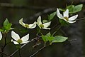
| img-flower = | | img-flower = Fireweed plant in the Yukon.jpg | ||
| cap-flower = The provincial flower, The Purple Tikapa </br>(''Tikapa tikapensis'') | | cap-flower = The provincial flower, The Purple Tikapa </br>(''Tikapa tikapensis'') | ||
| img-tree = | | img-tree = Blue-spruce-196660.jpg | ||
| cap-tree = The provincial tree, the West Jade Spruce (''Picea nephritus'') | | cap-tree = The provincial tree, the West Jade Spruce (''Picea nephritus'') | ||
| img-license = | | img-license = | ||
| Line 73: | Line 73: | ||
| img-custom1 = KT_Auldanweller_Valley_1.png | | img-custom1 = KT_Auldanweller_Valley_1.png | ||
| cap-custom1 = Auldanweller Valley in far west KT, with Mount Ernest on the far right. | | cap-custom1 = Auldanweller Valley in far west KT, with Mount Ernest on the far right. | ||
| img-custom2 = | | img-custom2 = CSIRO ScienceImage 3189 Beef cattle.jpg | ||
| cap-custom2 = A farm near the foothills of the Great Shield Mountains near Jasper, KT | | cap-custom2 = A farm near the foothills of the Great Shield Mountains near Jasper, KT | ||
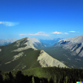
| img-custom3 = | | img-custom3 = Saddle Mountain (Oregon).jpg | ||
| cap-custom3 = The Queen Charlotte Mountains near New Cottingham, KT | | cap-custom3 = The Queen Charlotte Mountains near New Cottingham, KT | ||
| img-custom4 = | | img-custom4 = | ||
Revision as of 18:30, 8 December 2023
The provinces of the Deodeca are a constituent political entity within the country. This page provides a snapshot overview of some of the provinces.
| To include a state below, please use {{Snapshot Deodeca province}}. Note that there are required elements for the template to ensure a minimum amount of information (name, flag, capital, postal code, etc.). Information about required parameters may be found on the template page. Then, be sure to add the state to the table of contents manually. All states must appear in alphabetical order. |
| | ||
|---|---|---|
| Capital: New Reydon | Population: 10,100,550 | |
| Confederation: 1710 Etymology: Ingerish (used to differentiate claims from Franquese Asperie) + Asperia (name used for the southwestern coast of Astrasia). Demonym: Asperian | Postal code: IA Official motto: "Illustratio, Moralis, Prudentia." ("Englightenment, Morality, Prudence.") Provincial song: None | Largest city: Stonesipher Other population centers: Baptist Bay, Bathantown, Tidonmouth |
| Neighboring provinces: | ||
| Gallery of province symbols | ||

Flag of Ingerish Asperia

Coat of arms of Ingerish Asperia

The provincial bird, the White-arched Stormpetrel (Hydrobates asperinus)
The provincial flower, the White mobgray (Vinca hepburnii)
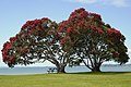
The provincial tree, the Ironwood tree (Metrosideros excelsa)

Rugged coastline along the Shiralees.

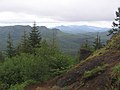
Foothills of the Great Shield Mountains near Coalcliffe, IA.


| | ||
|---|---|---|
| Capital: Coalburne | Population: 2,464,000 | |
| Etymology: Anglicised name derived from the Tsimshiliit word 'Kaasty’chyetshan.' Demonym: Kastichetshani | Postal code: KT Official motto: "Under the cross, we are well." Provincial song: Under The Cross, We Are Well | Largest city: Coalburne Other population centers: Delbert City, Port Stewart, Dimsdale, Cacsaw |
| Neighboring provinces: | ||
| Gallery of province symbols | ||

Flag of Kastichetshan

The provincial bird, the
Common Sapphire Dasher
(Malurus sapphirii)
The provincial flower, The Purple Tikapa
(Tikapa tikapensis)
The provincial tree, the West Jade Spruce (Picea nephritus)
Auldanweller Valley in far west KT, with Mount Ernest on the far right.

A farm near the foothills of the Great Shield Mountains near Jasper, KT
The Queen Charlotte Mountains near New Cottingham, KT


.jpg)