Izaland: Difference between revisions
m (→Demographics) |
|||
| Line 225: | Line 225: | ||
| religion_bars = {{bar percent|Peritan Christicism|blue|43.4}}{{bar percent|Budicism|red|28.3}}{{bar percent|Other|orange|2.1}}{{bar percent|Irreligious|gray|21.2}} | | religion_bars = {{bar percent|Peritan Christicism|blue|43.4}}{{bar percent|Budicism|red|28.3}}{{bar percent|Other|orange|2.1}}{{bar percent|Irreligious|gray|21.2}} | ||
| literacy = {{steady}} 100% | | literacy = {{steady}} 100% | ||
| life_expectancy = {{steady}} | | life_expectancy = {{steady}} 81.6 (male)<br /> {{decrease}} 86.3 (female) | ||
}} | }} | ||
Izaland boasts a population of over 117 million inhabitants. This substantial number places Izaland among the most densely populated nations in the region, with approximately 385 people per square kilometer. Remarkably, despite its density, certain areas, such as the vast inner regions of Kubori Island and the northeastern continental area, remain relatively untouched by intensive urban development. | |||
The vast majority, 92.1%, of the population identifies as members of the Izaki ethnicity, forming the cultural backbone of the nation. The remaining 7.9% comprises a vibrant community of immigrants, hailing primarily from neighboring Axian countries like UL30c, and Northern Archanta. Additionally, expats from other Ulethan nations such as Belphenia, Kojo, Pyokchin and Saikyel have also contributed to Izaland's recent cultural diversity. | |||
Urbanization has played a significant role in shaping Izaland's demographic landscape. A considerable 83.2% of the population resides in urban centers, drawn to major economic hubs that have thrived since the early days of industrialization. This trend continues to attract young individuals from rural areas seeking opportunities in these bustling metropolises. | |||
===Growth rate and fertility=== | |||
The demographic landscape of Izaland is undergoing significant changes, characterized by an aging population and increased life expectancy due to advancements in medical care. Additionally, the nation has experienced a rise in immigration. Despite the population boom that followed the Great War, the country is facing a challenge with extremely low population growth, primarily due to a low birth rate. In 2009, Izaland recorded the lowest absolute population growth since 1900. | |||
The Izaki population experienced significant growth in the 1960s, with peak growth rates ranging from 5.5% to 11.3% per year. However, over time, this growth rate gradually declined, reaching a near-static -0.09% in 2009. The nation faced challenges due to low fertility rates and an increasingly aging population, resulting in an imbalance. | |||
These demographic developments have far-reaching implications for health care and social security policies. As the Izaki population continues to age, the proportion of people of working age in relation to the overall population is declining. This trend poses challenges to the current system of old-age pensions, as fewer people contribute to the system while there are more recipients. Moreover, the anticipated increase in health care costs further compounds the situation. | |||
In response to these challenges, the National Statistics Office of Izaland has highlighted the need for reform in health care and social security systems. | |||
To address this demographic challenge, the Government,particularly the Araigaji cabinet, initiated measures to support young families by improving their welfare conditions. Additionally, efforts were made to attract quality migration from other developing countries. These policies started yielding results from the mid-2010s, leading to a timid but noteworthy increase in the population growth rate to 0.82% in recent years. | |||
Policy reforms are being implemented to address these issues, aiming to incentivize more people to join the labor market and create a greater awareness of health care spending. | |||
The focus on welfare and strategic migration has proven essential in reshaping Izaland's demographic landscape, allowing the nation to sustain a more balanced and dynamic population growth trend in the face of demographic changes. | |||
===Family composition=== | |||
Izaland underwent significant demographic and economic transformations before and after the Great War, leaving a profound impact on Izaki families. During this period, families became smaller, with the average number of persons per family dropping from 4.1 in 1940 to 2.5 by 1968. While family composition remained relatively stable over the quarter-century, there were notable percentages in various family types. In 1975, 24.4% of families consisted of a man and a woman, 61.9% of a couple with children, 11.8% of a woman with offspring, and 1.9% of a man with offspring. | |||
One significant change was observed in the number of children per family, which declined from an average of 3.43 in 1950 to 2.9 in the mid-1980s. Large families became rare, as only 3% of families had four or more children. On the other hand, 47% of families had one child, 44% had two children, and 6% had three children. | |||
The impact of these demographic shifts was evident in the number of Izaki individuals under the age of 18, which decreased from 39 million in 1960 to 17.3 million in 1980. These changes in family size and composition have contributed to shaping the social fabric of Izaland and have implications for future demographic trends and policies. | |||
===List of common Izaki surnames=== | ===List of common Izaki surnames=== | ||
In Izaland, the majority of surnames are crafted from two Bai characters, often imbued with meanings tied to geography or professions. With a repertoire of over 182,000 family names, Izaland boasts a diverse array of surnames that are widely dispersed across the nation. Among them, the most prevalent ones, such as Hansai and Samosāri, name about one million individuals each. | |||
Notably, around 1/6 of the population also possesses a middle family name, traditionally formed from a single character, a historical vestige of connections with the southern Kingdoms of Bai. Among these middle names, some of the most common ones include 金 (Kin), 李 (Rī), 百 (Pyaku), 陣 (Zhin), 張 (Chō), 福 (Fuku), 宮 (Kūn), among others. This rich tapestry of surnames reflects the intricate cultural heritage and historical influences that have shaped Izaki society. | |||
{| class="wikitable sortable" | {| class="wikitable sortable" | ||
|- | |- | ||
| Line 258: | Line 285: | ||
|- | |- | ||
| 12|| 長崎 || 𖬬ɭ𖬭𖬰ɭ𐐢ᐡ|| Regeul || 352,997|| 0.30 | | 12|| 長崎 || 𖬬ɭ𖬭𖬰ɭ𐐢ᐡ|| Regeul || 352,997|| 0.30 | ||
|- | |||
| 13|| 鍛冶 || 𖬖ᐟ𖭐フ𖬭ɭᒢ|| Saikkes || 312,002|| 0.29 | |||
|- | |||
| 14|| 平 || 𖬊フ𖬭ᥫ || Makkei|| 282,002|| tbd | |||
|- | |- | ||
|} | |} | ||
| Line 263: | Line 294: | ||
to be continued | to be continued | ||
=== | ===Ethnicity=== | ||
It is difficult to trace a genetic profile of the Izanish race, as since the dawn of time there has been a profound mixture of different ethnic groups, both Uletian and Arcanthic. Physiognomically, Izanish people's face appears to be of an oriental type, with dark hair, black almond-shaped eyes and a slightly pronounced nose. However, there is no lack of genotypes belonging to more Western races, such as lighter colored eyes (ocher, olive green and, very rarely, blue) and hair tending to brown. | It is difficult to trace a genetic profile of the Izanish race, as since the dawn of time there has been a profound mixture of different ethnic groups, both Uletian and Arcanthic. Physiognomically, Izanish people's face appears to be of an oriental type, with dark hair, black almond-shaped eyes and a slightly pronounced nose. However, there is no lack of genotypes belonging to more Western races, such as lighter colored eyes (ocher, olive green and, very rarely, blue) and hair tending to brown. | ||
Tracing a precise genetic profile of the Izaniki ethnicity poses a challenge, given the deep historical amalgamation of diverse ethnic groups, both from Uletian and Archantan origins. Physiognomically, Izaniki individuals typically exhibit facial features reminiscent of oriental or North-Archantan descent, characterized by dark hair, black almond-shaped eyes, and a slightly pronounced nose. | |||
Nevertheless, the genetic diversity extends to include genotypes associated with Western races, such as lighter-colored eyes in shades of ocher, olive green, and, on rare occasions, blue, along with hair shades tending towards brown. This intriguing blend is particularly observable in the northern regions, where frequent interactions with Kalmish populations have taken place in recent history. | |||
Despite these influences, Izaland's geographical isolation, framed by surrounding mountains and the sea, has largely contributed to maintaining relatively uniform somatic tracts throughout the nation's history. | |||
===Urban planning=== | ===Urban planning=== | ||
Revision as of 14:31, 26 July 2023

|
Republic of Izaland  華邦共和國 Izaki Kyohwakuku (Izaki) Capital: Sainðaul
Population: 117,319,252 (2023) Motto: 天ᒢ 𖬬ɭᐢ𖬧𖭐, 民ᒢ 𖬬ɭᐢ𖬧𖭐, 𖭑𖬨𐐢 団結𖬣ᐤ𖬭𖭐フ𖭑ɭ. / Asunas renshi, wikeris renshi, nahu dankes tokinne. (For heaven, for the people, we are united) Anthem: / 國𖭑𐐢𖬨ɭ, 天ᒢ 下ᐢ. / Askazhinuhe, asunas kaurin. (Our country, below the Heaven) |
Loading map... |
The Republic of Izaland (華邦共和國, Izaki Kyohwakuku), commonly referred as Izaland is a country in south-east Uletha occupying part of the continental landmass of Eastern Uletha and the whole island of Kubori (making part about the 20 % of the total 307,242.72 sq km of surface. The capital city is Sainðaul (also spelled Saindzaul), located across the Tandan Strait. Izaland's neighbor countries are Belphenia and Nuen to the east, UL28h, Sãikyel, and Blönland to the north, and Pyokchin to the west, while the southern part protrudes into the the Sound of Pa.
With nearly 118 million inhabitants, with a population density of 385 people per sq km, Izaland is one of the most densely populated nations, but most of the inhabitants live in the capital area (alone containing more than 22 million people) and in the bigger cities along Kubori island's western shore, such as Kichatsura, Panaireki and Warohan. Other major urban areas are Isadashi, about 100 km north from Sainðaul, Riyatoma, the main city of the central continental area, and Sannupuri, the largest port on the Gulf of Volta.
Izaland is an economically advanced nation, with high standards of life and wealth, boosted by the miraculous economical growth accomplished by the nation after the World war.
In Izaki (romanised): [👂 listen recording here]
Izaki kyohwakuku, tsōntsī Izaki (angerigounde Izaland), dōnnan-Urezhūs askashi yo. Izaki, Kubori-hamas ðennyukus (haiyo myensheku ðenkukudo 306,710 km2-s juitte yaku 20% yo) suma, Urezhū tairikis ispunli wichi to. Izakis shuto Tandan kaikyō toeyan Sainðaul yutte, daini toshi nanbun paikusumu Warohan yo. Izakis rinkukūn, shikisankan Saikyel ta Byulenlanti ta UL28h, narisankan Belfenya ta Nuen, nijisankan Pekutsin, sebunte otsumisankan Pākutō yohan.
Zhinkumisto 1 peipō kilometuri noilke 385 zhin yutte, zhinku yaku 118 mantōn yohan paemōn, juminnis daibubun shutokwennen ta Warohan, Panaireki, Kichatsuras kihtoken Kubori-hamas saibun yohan nazae ōdan toshīn pae. Nazae juyo tan toshibūn, juwon dairikus Riyatoma ta Sainðullul yaku 100 km nantanke yon Isadashi, epagohte Volta-hannas tsaidais sāreotoka yon Sannupuri yohan.
華邦共和邦', 通称 「華邦」 (𖬒ᐡ𖬭𖬰𑃸𖬬ᛁ語𖬒𐐢ᐡ𖬮𖬰𑃸 𖬒ᛁ𖬖𖬰𖬠ᐡd), 東南宇礼洲ᒢ 國 ꓩ𖬒𖬬𑃸. 華邦, 久保利島ᒢ 全域ᒢ (𖬨𖬒ᛁꓩ𖬒 面積全國土 306,710 km2-ᒢ 中ⲅ𖬮𑃸 約 20% ꓩ𖬒𖬬𑃸) 𖬖𐐢𖬊, 宇礼洲大陸ᒢ 一部ᐡ𖬠ᛁ 位置 𖬮ᐤ𖬬𑃸. 華邦ᒢ 首都 𖬮ᐡ𖬮𖬰ᐡ 海峡 𖬮ᐤ𖬒𑃸𐭘𖬒ᐡ 作安崎 ɿ𖬒ⲅ𖬮𑃸, 第二都市 南部ᐡ 𖬡𖬒ᛁ𖬭𐐢𖬖𐐢𖬊𐐢 深灣 ꓩ𖬒. 華邦ᒢ 隣国𖬒𐐢ᐡ, 北側ᐡ 𖬖𖬒ᛁꓶ𖬭ᘁ 𖬮 ɿ𖬇𖬰𖬈ɭᐢ𖬈ᐢ𖬁ᛁ 𖬮 𖬒𐐢ᘁ28H, 東側ᐡ 𖬡𖬰𑃸ᘁ𖬌𑃸𐭘𖭑 𖬮 𖭑𐐢𖬮ɭᐢ, 西側ᐡ 碧珍, 𖬖𑃸𖬡𖬰𐐢ᐡ𖬮𑃸 南側 𖬡𖬒海 ꓩ𖬒𖬬𑃸𖬨ᐡ.
人口密度 1 𖬡𑃸ᛁ𖬡ᐤ𖬒ᐤ 𖬭ᛁ𖬠ᐤ𖬊𑃸𖬮𐐢𖬬ᛁ 𖭑ᐤ𖬒ᛁᘁ𖬭𑃸 385 人 ɿ𖬒ⲅ𖬮𑃸, 人口 約 118 𖬊ᐡ𖬮ᐤ𖬒ᐤᐡ ꓩ𖬒𖬬𑃸𖬨ᐡ 𖬡𖬒𑃸𖬊ᐤ𖬒ᐤᐡ, 住民𖭑ᛁᒢ 大部分 首都圏𖭑𑃸ᐡ 𖬮 深灣, 若浦, 亀茶裂ᒢ 𖬭ᛁh𖬮ᐤ𖬭𑃸ᐡ 久保利島ᒢ 西部ᐡ ꓩ𖬒𖬬𑃸𖬨ᐡ 𖭑𖬖𖬰𖬒𑃸 大ᐡ 都市𖬒ᛁᐡ 𖬡𖬒𑃸𖬬𑃸. 𖭑𖬖𖬰𖬒𑃸 重要 他ᐡ 都市部𖬒𐐢ᐡ, 中央 大陸ᒢ 追庥 𖬮 作安崎𖬠𐐢ᘁ 約100 km 𖭑ᐡ𖬮ᐡ𖬭𑃸 ꓩ𖬒ᐡ 安村, 𖬒𑃸𖬡𖬭𖬰ᐤh𖬮𑃸 𖬌𖬰ᐤᘁ𖬮-灣𖭑ᒢ 最大ᒢ 港町 ꓩ𖬒ᐡ 乾山 ꓩ𖬒𖬬𑃸𖬨ᐡ.
History
| History of Izaland | |
|---|---|
| Kōmun Era 甲文時代) | until year 75 AD |
| Busshō Era 仏照時代 | 75 - 453 |
| Kanaskashi Era 二國時代 | 453 - 1178 |
The history of Izaland is still in progress and the following information might change in the future according to the development of other nations in Eastern Uletha.
Prehistory
Izaland is believed to have been settled since 50,000 BC, with migrations of settlers from western Uletha. The presence of tall mountain ranges in the central-northern part of the territory has meant that, until relatively modern times, the contacts between the populations of the north, and those of the south, were sporadic, and limited to feeble commercial exchanges.
The earliest populations were initially hunters and gatherers, and tended to settle along the great rivers of the central highlands, which offered environments rich in provisions and able to allow the continuity of the first communities. Often it was a matter of nomadic aggregations, which moved together with the animals that allowed their sustenance. The first agricultural techniques, spread from the west around the 13th century BC, allowed the improvement of the yield of crops, and the trade in rice, soybeans and other cereals led to the birth of the first cities and the first semi-organized communities.
The first urban centers in the north of the country were governed by a central family, who managed the administration relying on a series of senior councilors, as well as seers (called akeru, or ikoru), often represented by the elderly women of the village, who were believed were closest to the gods and spirits of nature.
A system in force in present-day western Izaland was that of the rindokareri in which a certain number of advisers and seers were exchanged between some allied villages, with the aim of providing more genuine data and predictions unrelated to possible elements of corruption or favors to certain inhabitants of a village.
1st to 8th century - The prominence of Illashun and Sopeke kingdoms

Around the year 0 the territory that currently corresponds to Izaland was divided into a large number of small non-centralized entities, with the exception of two kingdoms that were gradually starting to stand out in the local landscape: the Kingdom of Illashun (院良春王国, with its center in the current city of Illashiya), and the Kingdom of Sopeke (岨坪畍王国), located where the prefectures of Riyatoma and Makkenoke are now located, in the center of the continental area of Izaland.
The first trade between the two nations began to develop starting from the year 75 AD, when some inscriptions found in the historical site of Haketono (横榁) suggest that the diplomatic mission by Prince Kukeyatan Urevi had taken place who, from Illashun, went with a mighty escort, exploring to the north. This allowed the Illashun Kingdom to establish the first diplomatic relations with King Tainal II of Sopeke.
The two kingdoms experienced a certain period of peaceful coexistence and the main products of exchange were amber from the north and food products from the south.
However, around the 1st century AD, traders from the Nihonese homeland and the Bai Empire started to establish trading ports and coastal towns on the Ashin (Axian) Peninsula, resulting in strong Bai and Nihonese influences on the local cultures. After the Great Unification between the kingdoms of Illashun and Sopeke (1178) , the newly established Kingdom of Sopeshun rose into prominence around the 3rd century AD, and dominated most of Kubori Island and the Izaki mainland until its collapse in the 8th century. The Sopeshun Kingdom attempted several times to subdue the southern Kubori tribes to secure control of the coastal ports; the tribes instead unified to establish the rival Ipseris Federation that would remain outside Sopeshun control. With the fragmentation of the Sopeshun Kingdom, the Kubori King launched its conquests over the Izaki mainland.
The Ðenzhū era (the warring provinces)
9th century to 13th century - The Awangusain Dinasty
Until the 13th century, the new kingdom became the dominant power on the Axian Peninsula, with further expansion into Belphenia and surrounding states, making it - de facto - an Empire (made official with the Kyentei Law, in 1281). Ushering Izaland's golden age, especially during the rule of Emperor Haraba the Awangusain Kingdom controlled trade and established a network of tributary states in the region, strengthening relations with Pasundan and the Kojolese tribes, such as the Yochomryi.
The Sanbakai conflict (三馬懐紛争) (1298-1302) marked the end of the Awangusain Empire, turning it back to a weakened Kingdom. The Kubori islanders began to rebel against the Awangusain government due to opposition against increased taxation and the empire's failures to address the repeated floods and droughts. The merchants of the Bai Suo Dynasty took this opportunity to aid the rebels and overthrow the Awangusain Kingdom and, in 1302, Takihasu Mitsuburi, an eminent merchant originally from the Itakiri archipelago, enriched by his trading fleets which had contributed to bringing wealth both to the coffers of Awangusain and to those of other trading partners in the region, with his skilled diplomacy he obtained the role as a regional inspector for the southern part of Kubori from the Suo Dynasty. In 1312 he obtained the title of King, and took the name of King Chodae I.
13th century to 1xxx - The Nakai Kingdom, rise and collapse
The subsequent Nakai Kingdom (奈堺王国, from the name of the Royal Palace built in Warohan) was effectively a Suo protectorate, with Bai merchants granted concessions and privileges to dominate trade in the region. Under Bai's control, the coastal cities of Warohan, Daishin, Kanlisahna, and Kokendake (the former name of Sainðaul) expanded rapidly, as the Suo sought to install its own fleet to protect its possessions in the region.
Following the Suo's collapse, the Nakai Kingdom, for a brief period, became effectively independent from Bai control. The Nakai, along with Belphenia, Kojo and Pasundan, competed to take control of Bai's possessions in the Axian Peninsula, along with western Ulethan powers seeking colonisation opportunities in the region. The Nakai fell under the influence of Ulethan powers for the remainder of its existence, impacting local culture and customs.
19th century, the first attempts of a Republic, and a still divided country

With industrialization in the 19th century, the emergence of a working class led to several social problems that the Nakai monarchy was unable to deal with. Ideals of a democratic republic began to spread in Izaland, with Kojo's and Belphenia's transformation into a unitary republic and Bai's constitutional monarchy. Dissatisfaction with Ulethan overlordship led to a few rebellions, until the 1877 Panaireki Revolution that brought an end to the Nakai Kingdom.
The new Izaki Republic, however, soon split apart with the Republic of Kubori declaring independence over cultural and political differences between Kubori and the mainland. The Izaki Republic was brief, however, as its president took the breakaway as an excuse to amass executive powers and declared himself Emperor soon after. During the early 20th century, Kubori and Izaland waged a series of low-scale conflicts especially over the control of Saindaul. Kubori collapsed into a civil war between socialists and pro-democratic factions upon the death of its statesman. The Izaki Kingdom took this opportunity to seize control of Kubori and successfully annexed the island in 1934.
Later 20th century
Until the 50s, Izaland remained a totalitarian state, when the 3rd Izaki King began a series of democratic reforms, which halted briefly when a faction launched a coup and assassinated the Izaki King, igniting the the New Panaireki Revolution that eventually brought an end to the Izaki Kingdom and the establishment of the modern republic through a popular referendum held on 23 September 19 195x.
Geography - 地形
 | |
|---|---|
| Geography of Izaland | |
| Continent | Uletha (South-Eastern) |
| Region | Axian peninsular |
| Population | 117,319,252 (2023) |
| Area | |
| • Total | 307,973.48 km2 118,627 sq mi |
| • Water (%) | TBA |
| Population density | 383.6 km2 1,395.24 sq mi |
| Major rivers | Shinkōsari, Nozaba, Zaan, Kyunida |
| Major lakes | Satsohonu, Usumūn, Irinoen |
| Time zone | WUT+8:00 (IST) |

Izaland is located in the south-east Uletha, extending for about 306 thousands sq kilometers, following roughly the shape of a "T". Nearly the 78% of Izaland extension is contained into the Uletha continent, while the remaining territory is distributed on the islands of Kubori and those making the Itakiri Prefecture. Kubori island, one of the largest in Uletha, extends for about 62,000 sq km. The capital city, Sainðaul has the original center within the continental area, but it naturally expanded across the Tandan Strait, including the former city of Nikabul.
From a geographical point of view, we can divide the country into four macro-areas:
- In the northern part of Izaland, the Yenkaido prefecture boasts long sandy coastlines along its picturesque shores. This scenic coastal region offers stunning views and is a popular destination for seafood lovers and nature enthusiasts.
Within the Yenkaido prefecture lies the Rukatui National Park, known for its breathtaking caldera lakes. These stunning lakes, formed within volcanic craters, create a mesmerizing landscape. One notable feature is the isolated Wannepetsi volcano, standing tall at an elevation of 1761 meters. Its majestic presence adds to the allure of the national park and attracts adventurers and hikers.
Moving further east, the expansive Sonzhin plain unfolds, characterized by its vast open spaces and natural beauty. This region is home to two large bodies of water, namely Lake Mattomi and Lake Usumuun. Lake Mattomi offers tranquil surroundings and serves as a serene retreat for visitors seeking peace and tranquility. Lake Usumuun, on the other hand, is partially shared with Belphenia, another neighboring country, adding a unique international dimension to its allure. To the east of the Sonzhin plain, the East River Kyunida marks the border with Nuen. This river not only demarcates the boundary between the two countries but also serves as a significant geographical feature in the region.
The northern part of Izaland, also the lowest densely populated region, presents a diverse and captivating landscape, encompassing wild coastlines, volcanic wonders, expansive plains, and shimmering lakes. It offers a range of outdoor activities and scenic spots for locals and visitors to explore and enjoy.
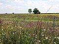
- The central part, a plain that extends diagonally from north-west to south-east for about 600 km, bordered to the north by the northern mountain range. This area sees the population concentrated in several medium-large urban centers, including Riyatoma, Makkenoke and Poridake, besides numerous mid-sized cities, each with a population of around 200,000 inhabitants. These urban centers form the heart of the country, bustling with activity, cultural diversity, and economic vitality. Due to the distance from the coasts, this area experiences a temperate continental climate, which causes hot summers and cold winters.
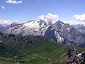
To the north of the central region lies the border with Blönland, a Germanic-speaking nation. This border is demarcated by the towering peaks of the highest mountains in Eastern Uletha. Among these majestic peaks stands Mount Torahashi, reaching a towering height of 5,187 meters. Revered as one of the symbols of Izaland, these mountains are not only awe-inspiring but also serve as the source of countless rivers that flow through the region. The area is dotted with magnificent glaciers and national parks, showcasing the unspoiled beauty of nature.
In the northwest, where the central part meets Pyeokchin, lies the remarkable Wenchogwon marshland. This expansive marshland is renowned as an important bird migration route. Thousands of ospreys, cranes, marsh wrens, ibises, and various other bird species grace the area during their seasonal journeys. The marshland's origin can be traced back to an ancient lake that once occupied the region, with the Shinkōsari River serving as a testament to its legacy.
Nestled between the cities of Fukuoka, Ārikkotsawa, and Rinnajin, the Kajurahi Mountains stand as another notable feature of the central region. This massif is a geological marvel, offering picturesque landscapes and serving as the nearest mountain resort to the capital city. The Kajurahi Mountains provide opportunities for outdoor enthusiasts to engage in activities such as hiking, skiing, and exploring the natural wonders of Izaland.
The central part of Izaland embodies the dynamic fusion of urban development and natural grandeur. It is a region that harmoniously blends the energy of thriving cities, the majesty of mountainous landscapes, the allure of bird-filled marshlands, and the tranquility of mountain resorts.
- The coastal area, which extends in the southern part of the Ulethian area, and along the coasts of the island of Kubori. The climate varies from coastal temperate to subtropical temperate. This area is prone to monsoon disturbances coming from the south-east.
- The southern coasts of Kubori and the smaller islands, whose characteristics are found in a subtropical climate with a strong presence of seasonal rainfall.

The northern coast on the Gulf of Volta

The vast marshland of Wenchogon working as a separation between Izaland and UL31c
Glaciers on the top mountains of the northern range.
The vast farmlands in the eastern region

A tropical scenery of Itakiri Prefecture
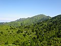
Forest cover in the middle part of Kubori

View on the Bonhama Naekai, the inner sea between the continental Western coast and Kubori Island


Islands - 島系


As already stated, Kubori island makes up nearly the 20% of national territory, and has a regular rectangular shape with a depression on the western side, where Panaireki Bay is located. Most of the settlements are located along the western coast, with the inner area almost unspoiled and still covered by subtropical forests, especially farther south. The south-western part of Kubori island has an intricate system of peninsulas, pointing at the Itakiri Islands.
The Itakiri archipelago is mainly made up by three subtropical island groups:
- The Sāndaidō Archipelago (双大島諸島, Sāndaidō tsodō), comprising the largest island in the north, Itakiri, Bikuore, Oingos, Luminoe and Yeron, plus other minor islands;
- The Kōmuvai Archipelago (---諸島, Kōmuvai tsodō), made up by the little islands of Katohawa, Sānpelui and Imonatu, the southernmost point of Izaland, placed about 45 km south from Oingos;
- The Ogamoton Archipelago (---諸島, Ogamoton tsodō), formed by Ogamoton, Zodovaku, and other islands, including Gifawonna
Most of the territory is occupied by the , and the islands of Itakiri and Bikuore, both exceeding 1,000 square kilometers are the main economical centers of the prefecture. The largest cities are located on these islands, including Sagoma, the capital, and Ketserano (both them on Itakiri), with Atsujīl and Kikknās being the other two biggest cities on Bikuore.
The Sāndaidō Archipelago alone is the vastest among them, and the two main islands are Itakiri and Bikuore, both exceeding 1,000 square kilometers. They have a volcanic origin, and some active volcanos are still present, for example Mount Gusomeki (3421 m) on Oingos, and Mount Eikenjawi (2287 m), on eastern Itakiri. Other notable volcanic islands are Oingos and Luminoe. Besides volcanic islands, there are many coral islands, and in Itakiri the two rare only atoll formations of Izaland are located: Saðuren atoll, and Nukusabo atoll complex (famous for the Heaven Lagoon surrounding the main island within the reef). This precious ecosystem is in danger due to the erosion.
On the south-east of Kubori Island the land extends into the Kaiton Peninsula, pointing south. Off shore, another archipelago of islands, including Basotachi and Ogamoton extends. Izaland has over 400 among islands and inlets, mostly near the coastline, with some exceptions. Most of the biggest islands are comprised within Itakiri Prefecture, where Itakiri and Kahadu islands are the largest ones, each about 1,100 square kilometers wide. Itakiri, Kahadu and the nearby islands are volcanic islands and, despite the limited landmass, they have some peaks exceeding 3000 m.
Other notable islands are Oingos and Ogamoton, still in Itakiri, and Nurihara, making up Midōhinnan Prefecture. As a notable geomorphological feature, the westernmost point of Izaland is the volcanic island of Tsohana, connected with Kubori island by an isthmus.
The Tandan Strait, accross of which the capital is located, is also home to many smaller islands. Since they are located close to the coastline in a highly densely populated area, often they are linked with bridges or tunnels to the mainland. Other island located in sea are Fuendaru, Sumasai and Tekirunan.
Finally, Yenkaidō Prefecture, in the north, also a couple of major islands, Shirituku and TBD island.
Rivers - 河川
[To be updated] The main rivers of Kubori island are the Zaan (蓙杏河, Zaan sāri) flowing for 315 km in the south-western part of Kubori island. The river starts in the Jogare mountains, and its estuary is located where the city of Warohan expands. Other notable rivers in Kubori islands are the Nozaba (濃沙芭河, Nozaba sāri) (182 km) and the Kankayue (巻嘉巍河, Kankayue sāri) (218 km).
Mountains - 山脈

The mountainous reliefs account for about 40% of the surface of Izaland, and are distributed over almost the whole of the island of Kubori, and in the central and northern parts of the continental sector.
The main mountain range is that of the TBD mountains, located between Izaland and the republic of Sanain. These mountains culminate in peaks that reach 5000 m, among which we can mention Mount Torahashi (5189 m) and the Peak Mamuhun (5077 m), the highest peaks in eastern Uletha.
The TBD mountain range, after having demarcated the border with Teberia, and the republic of Sanain, near the Daityenguku National Park it forks, continuing along the border with and UL28f on one side, and marking the geographical division between the prefecture of Yenkaido to the north, and the rest of the continental part to the south. This mountainous section, called the Nokonupuri Mountains (in the Aynu Itak language means "saw-shaped mountains"), which reaches 3200 m in height in the west and gradually degrades to the east, prevents the cold northerly winds from reaching the southern part of Izaland, thus creating a clear climatic division between the north and south of the country.
Around the Usumun lake, in the eastern part of Izaland, there is another smaller mountain massif, that of the Jakumiwa mountains. The main peak is Mount Turigas, 2657 meters high.
Climate
Thanks to the privileged position, and the north-south extension of the country, Izaland enjoys different climates, from the alpine to the tropical one. Most of the population lives in a humid subtropical climate area, with a distinctive distribution on the western coast of the island of Kubori, and the plains placed in the center - western part of the Ulethan side. The average temperature in the capital, Sainðaul, is around 20,5 °C, with maximum average of 30°C and minimum average of 12°C
The climate zone can be roughly divided into three zones: the northern area, close to the Aigan Mountain Range, including 5000 m high peaks, sees continental to alpine climate. This area sees frequent snowfall between December to early March. Moving to the area around the capital, the climate shifts to humid subtropical, with long hot summers, cool winters, and summer peak to annual precipitation. On the south-western tip of the insular part of the country, the subtropical climate has some tropical characteristics, while the south-east and the east coast has a tropical monsoon climate, with a wet season from May to October, a dry season from November to April, and consistently very warm to hot temperatures with high humidity.
Ogamoton , Sānpelui and Kotohawa islands, in the south, have a lowest temperatures which never goes below 15°C even during the winter, making them an international holiday resort, especially famous for diving and leisure sports.
Demographics
| Demographics of Izaland | |||||||||||||||||||||
|---|---|---|---|---|---|---|---|---|---|---|---|---|---|---|---|---|---|---|---|---|---|
| Demonym | Izaki | ||||||||||||||||||||
| Official languages | Izaki | ||||||||||||||||||||
| Recognized minority languages | Aynu Itak, Konbaki, Eituus | ||||||||||||||||||||
Ethnicities | |||||||||||||||||||||
| |||||||||||||||||||||
Religion | |||||||||||||||||||||
| |||||||||||||||||||||
| Literacy | |||||||||||||||||||||
| Life expectancy | |||||||||||||||||||||
Izaland boasts a population of over 117 million inhabitants. This substantial number places Izaland among the most densely populated nations in the region, with approximately 385 people per square kilometer. Remarkably, despite its density, certain areas, such as the vast inner regions of Kubori Island and the northeastern continental area, remain relatively untouched by intensive urban development.
The vast majority, 92.1%, of the population identifies as members of the Izaki ethnicity, forming the cultural backbone of the nation. The remaining 7.9% comprises a vibrant community of immigrants, hailing primarily from neighboring Axian countries like UL30c, and Northern Archanta. Additionally, expats from other Ulethan nations such as Belphenia, Kojo, Pyokchin and Saikyel have also contributed to Izaland's recent cultural diversity.
Urbanization has played a significant role in shaping Izaland's demographic landscape. A considerable 83.2% of the population resides in urban centers, drawn to major economic hubs that have thrived since the early days of industrialization. This trend continues to attract young individuals from rural areas seeking opportunities in these bustling metropolises.
Growth rate and fertility
The demographic landscape of Izaland is undergoing significant changes, characterized by an aging population and increased life expectancy due to advancements in medical care. Additionally, the nation has experienced a rise in immigration. Despite the population boom that followed the Great War, the country is facing a challenge with extremely low population growth, primarily due to a low birth rate. In 2009, Izaland recorded the lowest absolute population growth since 1900.
The Izaki population experienced significant growth in the 1960s, with peak growth rates ranging from 5.5% to 11.3% per year. However, over time, this growth rate gradually declined, reaching a near-static -0.09% in 2009. The nation faced challenges due to low fertility rates and an increasingly aging population, resulting in an imbalance.
These demographic developments have far-reaching implications for health care and social security policies. As the Izaki population continues to age, the proportion of people of working age in relation to the overall population is declining. This trend poses challenges to the current system of old-age pensions, as fewer people contribute to the system while there are more recipients. Moreover, the anticipated increase in health care costs further compounds the situation.
In response to these challenges, the National Statistics Office of Izaland has highlighted the need for reform in health care and social security systems. To address this demographic challenge, the Government,particularly the Araigaji cabinet, initiated measures to support young families by improving their welfare conditions. Additionally, efforts were made to attract quality migration from other developing countries. These policies started yielding results from the mid-2010s, leading to a timid but noteworthy increase in the population growth rate to 0.82% in recent years.
Policy reforms are being implemented to address these issues, aiming to incentivize more people to join the labor market and create a greater awareness of health care spending. The focus on welfare and strategic migration has proven essential in reshaping Izaland's demographic landscape, allowing the nation to sustain a more balanced and dynamic population growth trend in the face of demographic changes.
Family composition
Izaland underwent significant demographic and economic transformations before and after the Great War, leaving a profound impact on Izaki families. During this period, families became smaller, with the average number of persons per family dropping from 4.1 in 1940 to 2.5 by 1968. While family composition remained relatively stable over the quarter-century, there were notable percentages in various family types. In 1975, 24.4% of families consisted of a man and a woman, 61.9% of a couple with children, 11.8% of a woman with offspring, and 1.9% of a man with offspring.
One significant change was observed in the number of children per family, which declined from an average of 3.43 in 1950 to 2.9 in the mid-1980s. Large families became rare, as only 3% of families had four or more children. On the other hand, 47% of families had one child, 44% had two children, and 6% had three children.
The impact of these demographic shifts was evident in the number of Izaki individuals under the age of 18, which decreased from 39 million in 1960 to 17.3 million in 1980. These changes in family size and composition have contributed to shaping the social fabric of Izaland and have implications for future demographic trends and policies.
List of common Izaki surnames
In Izaland, the majority of surnames are crafted from two Bai characters, often imbued with meanings tied to geography or professions. With a repertoire of over 182,000 family names, Izaland boasts a diverse array of surnames that are widely dispersed across the nation. Among them, the most prevalent ones, such as Hansai and Samosāri, name about one million individuals each.
Notably, around 1/6 of the population also possesses a middle family name, traditionally formed from a single character, a historical vestige of connections with the southern Kingdoms of Bai. Among these middle names, some of the most common ones include 金 (Kin), 李 (Rī), 百 (Pyaku), 陣 (Zhin), 張 (Chō), 福 (Fuku), 宮 (Kūn), among others. This rich tapestry of surnames reflects the intricate cultural heritage and historical influences that have shaped Izaki society.
| Rank | Name | Askaoza | Romanization | Estimated number (2020) | Occupation rate (%) |
|---|---|---|---|---|---|
| 1 | 飯斎 | 𖬨ᐢ𖬖ᐟ𖭐 | Hansai | 1,129,990 | 0.96 |
| 2 | 山川 | 𖬖𖬊ᐤ𖬖։𖬬𖭐 | Samosāri | 1,092,229 | 0.93 |
| 3 | 船造 | 𖬭ᐢ𖬈𖭐𖬖ᐤ𖬊 | Kanlisoma | 928,002 | 0.79 |
| 4 | 田中 | 𖬬𖬒𖭐𖬡𖬰𐐢 | Raibu | 919,220 | 0.78 |
| 5 | 大木 | 𖬒ᐤ։𖬣𖬰𖬖ꓩ𖬮 | Ōdasayo | 857,229 | 0.73 |
| 6 | 森見 | 𖬑𐩬𖬒𖭑ᐤ | Tsawano | 843,002 | 0.72 |
| 7 | 鹿田 | 𖬣ᐤフ𖬣ᐢ𖬨ᥫ𖬬 | Tottanheira | 728,229 | 0.62 |
| 8 | 神仕 | 𖬨𖭑ᦴ𖬬𖭑 | Hanuirana | 701,992 | 0.59 |
| 9 | 賈網 | 𖭑𐐢𖬣𖬖𖬰ᐤ𖭐 | Nutazoi | 629,220 | 0.53 |
| 10 | 西村 | 𖭑𖭐𖬥𖬰𖭐𖭑𖬣 | Nijinata | 402,339 | 0.34 |
| 11 | 島人 | 𖬨𖬊𖬣ᐤ | Hamato | 381,002 | 0.32 |
| 12 | 長崎 | 𖬬ɭ𖬭𖬰ɭ𐐢ᐡ | Regeul | 352,997 | 0.30 |
| 13 | 鍛冶 | 𖬖ᐟ𖭐フ𖬭ɭᒢ | Saikkes | 312,002 | 0.29 |
| 14 | 平 | 𖬊フ𖬭ᥫ | Makkei | 282,002 | tbd |
to be continued
Ethnicity
It is difficult to trace a genetic profile of the Izanish race, as since the dawn of time there has been a profound mixture of different ethnic groups, both Uletian and Arcanthic. Physiognomically, Izanish people's face appears to be of an oriental type, with dark hair, black almond-shaped eyes and a slightly pronounced nose. However, there is no lack of genotypes belonging to more Western races, such as lighter colored eyes (ocher, olive green and, very rarely, blue) and hair tending to brown.
Tracing a precise genetic profile of the Izaniki ethnicity poses a challenge, given the deep historical amalgamation of diverse ethnic groups, both from Uletian and Archantan origins. Physiognomically, Izaniki individuals typically exhibit facial features reminiscent of oriental or North-Archantan descent, characterized by dark hair, black almond-shaped eyes, and a slightly pronounced nose.
Nevertheless, the genetic diversity extends to include genotypes associated with Western races, such as lighter-colored eyes in shades of ocher, olive green, and, on rare occasions, blue, along with hair shades tending towards brown. This intriguing blend is particularly observable in the northern regions, where frequent interactions with Kalmish populations have taken place in recent history.
Despite these influences, Izaland's geographical isolation, framed by surrounding mountains and the sea, has largely contributed to maintaining relatively uniform somatic tracts throughout the nation's history.
Urban planning
A characteristic of the territorial development of Izaki urban centers lies in the fact that, compared to other nations, there are few small isolated villages, while the number of large and medium-sized cities is greater. This is due not only to a greater ease in the distribution of goods, but also to the ancient philosophy of "jiyenchohwashisān" (自然調和思想), or "thought of harmony with nature", drawn up from the 5th century BC by the Taemasa dynasty.
This method of land planning was based on both scientific and astrological criteria, and the positioning of towns and villages was well defined. As the Taemasa dynasty aggregated, through conquests, new territories that had independently developed their regional urban planning, it came, in certain cases, to relocate entire villages, if they did not respect the precepts of the "jiyenchohwashisān".
Although urban planning is still based on modern criteria, the ministry of the environment keeps a careful eye in order to avoid land consumption in the territory.
Government - 政府
| Government of Izaland | |
|---|---|
| Parliamentary republic | |
| Capital | Sainðaul |
| Head of state | |
| • President | Irokki Shinsayamo |
| • Prime Minister | Tariki Tara |
| • Ministry of Justice | Yukki Uitanma |
| Legislature | National Assembly (國會議事堂) |
| • Upper house | Daiwiwinkwi (代議員會) |
 | |
| • Lower house | Gwannowin (元老院) |
| Judiciary | Supreme Court of Izaland |
Major political parties | |
Minjudān 民主党: 251 seats Shinhwadān 新華党: 174 seats Tsinkukudān 進國党: 39 seats Ankukukwi 安國會: 28 seats Izaland Communist Party 華邦共産党: 22 seats Gonshutai 厳手隊: 16 seats | |
| AN, IWO, EUOIA, ASUN (observer) | |
Administrative Divisions and cities
See Administrative divisions of Izaland
State system
Izaland is a parliamentary republic. Executive power is mainly entrusted to the government, headed by the prime minister. National security affairs are divided between the president and the prime minister. The government shares responsibility for foreign affairs with the president.
Legislative power is exercised collectively by the Chamber of Deputies (代議員會, Daiwiwinkwi) and the Senate (元老院, Gwannowin) which together constitute the National Assembly (國會議事堂, Kukkaiwishidān). The chamber has 530 members, the Senate 208. Both chambers are renovated every five years.
Legislative initiative rests with deputies, senators and the Council of Ministers.
Executive power is exercised by the Prime Minister and the Council of Ministers. The President of the Republic appoints the Prime Minister and, upon his proposal, the ministers. The Council of Ministers must obtain the confidence of the Chamber of Deputies.
The President of the Republic is elected by direct suffrage every five years. A citizen who has reached the age of 30 can be elected president. He is also involved in foreign policy and national defense.
The judiciary is represented by the Supreme Court (最高裁判院, Tsaikosaipannwin), composed of judges appointed by the President of the Republic under the recommendation of the National Council of the Judiciary for an indefinite period, and by the Constitutional Court (憲法裁判院, Kenpōsaipannwin), composed of 28 judges chosen by the Chamber of Deputies for a six-year term.
Ministeries
Izaland has 13 ministries and two commissions. Their names and information are given in the table below.
| Name | Izaki | Minister | Map |
|---|---|---|---|
| Ministry of Agriculture, Forestry and Fisheries | 農林水産部 (Nōrin-Suisanbu) | Rihasamo Yungas | |
| Ministry of Communications and Digitalisation | 通信𖬒𖬰ᛁ𖬐𖬰ᛁ𖬁ᐤᐡ化部 (Tsōnshin-Dijitolkabu) | Zharaku Margerītta | |
| Ministry of Labour and Welfare | 厚生労働部 (Kōseirōdōnbu) | Hansai Jān Yanabu | |
| Ministry of Cultural Heritage and Tourism | 文化遺産観光部 (Munkwa-Wisan-Kwankwōbu) | Shobenihki Laura | |
| National Health and Sports Commission | 衛生健康委員會 (Weisei-Kēnkān Wiwinkwi) | Tottanheira Yūnki | |
| Ministry of Defense | 國防部 (Kukubānbu) | Baba Daryu | |
| Ministry of Economy and Finance | 經濟財政部 (Keiðai-Ðaiseibu) | Tentossan Chechila | |
| Ministry of Education and Research | 教育研究部 (Kyōiku-Kenkyunbu) | Kawadanki Misae | |
| Ministry of Foreign Affairs | 外務部 (Waimubu) | Nutazoi Taski | |
| Ministry of Trade and Industry | 商務産業部 (Shānmu-Sanwyabu) | Wikehake Anuppi | |
| Ministry of Internal Affairs | 内務部 (Naemubu) | Ōdasāri Kasume | |
| Ministry of the Environment and Green Policies | 環境翠策部 (Kwankyōn-Shuitsakubu) | Tanjinen Rika | |
| Ministry of Land, Infrastructure and Transport | 國土基設交通部 (Kukudo-Estonore-Kōtsōnbu) | Ilgerunta Rī Saomi | |
| Ministry of Justice | 法務部 (Pōmubu) | Uitanma Yukki | |
| National Public Safety Commission | 國家公安委員會 (Kukka-Kōan Wiwinkwi) | Hinutake Seizhi |
Flag
| Color scheme | Dark Gray Blue | Red | White |
|---|---|---|---|
| CMYK | 0/79/84/27 |
0/29/78/0 |
90/67/0/34
|
The Izaland flag consists of a blue background, inside which there are two concentric circles, a central red one, surrounded by a white ring. Blue, the symbolic color of Izaland, represents at the same time the color of the sea, and of the numerous streams and lakes that cover the surface of the nation. The red circle indicates the rising of the sun in the east, a direction that has always been of great importance for Izaland, as to the east there is the open sea, and therefore all the trade routes. The white surrounding the red sun indicates the light of the midday sun which, thanks to its heat, allows agricultural activities to flourish. Similarly, the white color is an element with a strong symbolism as an element of purity, according to the Izaki philosophy.
Economy - 経濟
See: Economy of Izaland
Transportation and infrastructures
Izaland counts on an extensive network of roads, railways and maritime links to sustain the high demand of public transportation in the country.
See: Infrastructure in Izaland
Culture
Religion
Izaland, located in a strategic position connecting South-Eastern Uletha and thus Archanta and Northern and Western Uletha, has been since the past times a crossroad for many different cultures, thoughts and religions. Nowadays, the main religions in Izaland are Buddhaism (tentative name), Christism and Hanuism, the latter being Izaki's eclusive religion.
Cuisine
The Izaki cuisine represents a meeting point between the culinary traditions of Northern Archanta and Western Uletha, with an emphasis on the use of fresh and possibly unprocessed ingredients. For geographical and historical reasons, the culinary style varies considerably from north to south.
Southern dishes are much closer to Archanta cuisines, focusing on rice and seafood, while the continental area sees a greater influence of Nordic cuisines, with potatoes and other tubers appearing on the table more often, as well as farinaceous products (in Izaland bread made with rice flour is widely consumed and, in the northern regions, that made with rye flour is the most common).
- Typical base aliments
- 米包, konunakke - rice bread
- 白米, charakonu - white rice
- 二粒麦, "opira" - emmer wheat
- 芋, "wataba" - potato
- 甘芋, "alkawataba" - sweet potato

Rice bread
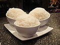
Cooked white rice

蝦麦混菜 sonukki bakuhonna' (prawn emmer salad)'

𖬮ɭ⸠𖬈ᐢ𖬒𖬰ᛁᒢ𖬇ᛁ𖬬𖬘𖬳ᛁ ēlandispirakki, a rye bread stuffed with mashed potato and porridge

"sannupuriwataba", a typical Yenkaido's potato dish

饂飩 "untun", typical noodles appreciated in Izaland and neighbouring countries


- Seafood dishes
Fish makes up the vast majority of the protein content of the Izaki diet, consumed both raw (rijome) and cooked. The cooking styles are very varied, using both Archantian-influenced condiments (soy sauce, coconut oil) and methods typical of the Kalmish nations of Western Uletha.
- 新鮮丼 Shinsen-fudoa - a bowl of rice covered by fresh raw fish (rijome)
- 立鮪丼, Imihatsi-fudoa - a regional variation of the sasumihewa-fudoa mainly eaten in Imihatsorul. Lean tuna is dipped in a special sauce containing soy sauce, sugar, sake, sesame seeds, egg yolk, etc., and placed on top of the rice. Typical toppings are green onions and ginger.
- 生身, Rijome - fresh raw fish usually flavored with soy sauce and lemon juice
- 𖬊𐐢𖭑ɭᣗ魚, "munermiwē" - cooked fishe like trouts, plaices or fillets of haddock, coated in flour , fried in butter until golden brown, sprinkled with lemon juice and covered by parsley, usually served with potatoes; this recipe comes from the northern countries such as Blönland and Saikyel, and is totally integrated into the local diet in northern Izaland.

A lily-root rice bowl (百合根丼 sasumihewa-fudoa)

新鮮丼 shinsen-fudoa

新鮮丼 shinsen-fudoa

Different kinds of rijome (sashimi) (生身, rijome)

𖬊𐐢𖭑ɭᣗ魚 "munermiwē", a western style cooked fish dish

A bowl of dry thick noodles (太麺丼, gimuramyen-fudoa)


.jpg)

- Meat
The kinds of meat mainly consumed in Izaland are, in addition to fish, chicken, and, to a lesser extent, pork beef, and mutton in the north, however, compared to other nations, the consumption of meat is relatively low, due to religious and ethical reasons (about half of the inhabitants of Izaland appear to be pescatarians). Intensive farming is not allowed, and all meat is generally imported or produced locally at organic farms, although this means that meat is more expensive than elsewhere. However, vegetarian alternatives are very readily available, particularly soy products, such as tofu (豆腐, nateyunbe) and seitan, as well as lab-grown meat (擬肉, suikkohei), which can be purchased for a similar price to that produced locally in almost any supermarket.

Mutton BBQ, typical of Dōnpuku and Yenkaido regions (北山肉, hukuzanhei)

A mixed salad (混盛鮮菜 honsei-shelkya)

A chicken cutlet (鶏𖬭𖬁𐐢𖬈ɭᒢ tasuta-katules)

A tempeh burger, a very common vegetarian snack (𖬁ɭᐢ𖬇ɭ𖬇𖬰⸠𖬭𖬰ɭᣗ tenpebāger)

A mix of vegetarian snacks based on tofu and beans (素菜混盛, sotsaihonsei)
A bowl of dry thick noodles (太麺丼 gimuramyen-fudoa)


- Sweets and desserts
The Izaki confectionery tradition is heavily based on the use of seasonal fruit and natural sweeteners, such as cane sugar. Very common flavors are mint, green tea (抹茶, mascha), coffee and red beans (赤豆, nabie). Western pastry also reaches high levels, especially in the north of the country, where, for historical reasons, the cuisine has been influenced by the nations of the northern Uletha.

𖬁𐐢𖬨𖬭𖬰ᛁ, tuhagi, red bean paste filled batter sweet.

抹茶盃菓子, mascha-tassuokwashi, green tea cupcakes

𖬊ɭᐢ𖬐ᐤ𖬭ᛁ menchoki, mint chocolate snacks and sweets are very appreciated by Izaki people, especially during summer

Modern patisserie is very popular in Izaland, and the chokoechoki (lit. "the afternoon chocolate") is a favorite appointment especially for many girls

Summer (and even winter, in the south) are great for refreshing fruit juices.

.jpg)


.jpg)
Territory-specific topics
|
Global topics
|