Collab:Plevia
- This article is about the territory UL08f, and the project's info. For the country of Plevia, see Plevia.
Loading map... |
Loading map... |
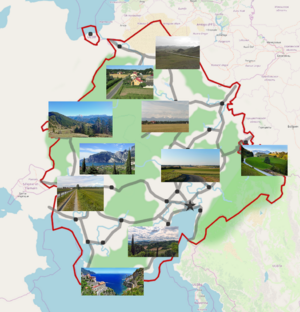
Located in Western Uletha, UL08f is a collaboration project inside OGF, and the only one (excluding privately owned territories) related to real-world Italy.
Project contributors
Key mappers
- Izaland - Manager of the project.
- Mtejku222 - Starter of the project
- seasvnz - Since summer 2022 (Omissa)
- Alexmar983 - Since November 2022, various minor improvements on the whole territory
Former or guest mappers
The following list includes users who extensively contributed in mapping Plevia
- Davierr - Main contributor.
- Lithium-Ion - Main contributor.
- BMSOUZA - Since November 2022 (Colleferro and Nabiana)
In training or occasional mappers
- Geoc3ladus - Since August 2023, various town detailing, mainly around Osianopoli
- Ciaosamuu - Since July 2022 (Condona)
- stefano20p - Since December 2022 (Cala Agra)
- ante44 - Main contributor in the past.
Rules for joining
Contact Izaland if you are interested in participating. To map in Plevia it is essential that you are able to map cities in Italian style (old towns, piazzas, castles and churches) and have a basic knowledge of Italian language.
Plevia mapping style

(from Mtejku222's idea:) Since it's supposed to be OGF:Italy, it's going to be quite similar to it in terms of culture and, to a lesser extent, history. However, it's located significantly further north, with its southernmost point being at the same latitude as central Italy and its northernmost point not far from Leipzig, Germany. For this reason, its climate will be Mediterranean in the south, oceanic in the west, humid subtropical in the east, and continental to arid in the north.
Economically, it will be slightly poorer than Italy, with the south-east and the south-west being generally richer than the north for historical reasons. The territory is larger than Italy and will have a similar population density (192 people/km2 vs. Italy's 201/km2); the population will be around 92 million. The capital city will also be the largest, and will be located in the south-east. It will serve as the cultural and historical centre of the country. It won't be too similar to Rome, but will have been a major hub of the OGF:Latin world in a distant past.
The country will receive strong cultural influences from other nations, especially near the borders: Arabic in the south (kind of like Sicily, and there might be certain places where Maltese is spoken); Venetian in the south-east (given the presence of Navenna); Turkic further to the north; Surian in the east; Antigoan (English/Latin) in the north; and Valonian in the west. There might be a separatist movement near Valony. Of course, the main culture will be Italian-like, just like the language. However, I don't want it to be too similar, so this is as analogous as the country will get to its real world counterpart; most other things I will try to make original.
Current areas in activity
| Mapping | Notes |
|---|---|
| Osianopoli - The Capital
Loading map... |
|
| Temisa - The second city
Loading map... |
|
| Costa - A port city on the western coast
Loading map... |
|
Administrative divisions
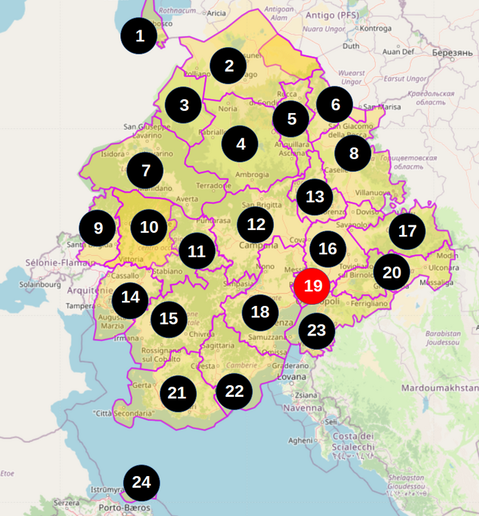
A proposal, based on the current situation, of the regions of Plevia.
| Level 2 | Level 3 | Level 4 | Level 5 | Level 6 |
|---|---|---|---|---|
| Plevia | Regions | Provinces | Cantons | Comunes |
Cantons (Cantoni): Subprovincial administrative subdivision, which is non-elective. They delineates homogeneous portions of territory that encompass similar municipalities or indicates portions of urban neighborhoods, for service provision.
Services provided on the territory by regions or mandated by law coordinated by municipalities are delivered on a cantonal basis. Thus, tourism offices, school bus lots, local waste collection centers, local hospitals, local police and firefighters, animal shelters, and tourism offices are among the services typically organized at the cantonal level.

| N | Name | Ref | Capital | Extension | Population | Brief description |
|---|---|---|---|---|---|---|
| 1 | Pretannica | PR | Pradibosco | Protruding region, facing Pretannic Lake | ||
| 2 | Alcamo | AC | Coveria | Steppes, underdeveloped region, some nomadic minorities, gas and mineral extraction | ||
| 3 | Massabria | MS | Cadelfia | 13,609 km² | ||
| 4 | Rovonia | RV | Penacampi | 34,957 km² | Large region with mountains and archaeological sites of ancient civilisations | |
| 5 | Gralesia Occidentale | GC | Rocca di Contadinassa | 11,338 km² | Mountain resort of Plevia | |
| 6 | Gralesia Orientale | GR | Morena | 8,984 km² | Possibly had a communist past? Nouns with Slavic influences | |
| 7 | Lavarinato | LV | Lavarino | 36,023 km² | Far away community, the life standards are below Plevia average, beautiful unspoiled nature with volcanic lakes | |
| 8 | Transgorizia | TG | Sarri | 26,100 km² | Possibly had a communist past? Nouns with Slavic influences | |
| 9 | Ludna | LD | Ludna | 11,127 km² | Larger Valonian speaking minority | |
| 10 | Glasponto | GP | Acqualonga | 20,091 km² | ||
| 11 | Bardigliera | BD | Ponte Bodesio | 38,155 km² | ||
| 12 | Campanese | CP | Campana | Productive region, and one of the best food destinations | ||
| 13 | Norenzano-Valbrenna | NV | Norenzo | 11,649 km² | Region rich in history and art | |
| 14 | Temisano | TM | Temisa | Region of the second city of Plevia, about 20% of population speaks Valonian as native language, similar to Liguria | ||
| 15 | Mescadia | MC | Costa | Similar to Liguria, once an important maritime power | ||
| 16 | Valcesia | VC | Luviana | 19,245 km² | Rich region with factories and high agricultural production (RW Emilia Romagna?) | |
| 17 | Oltresuria | OS | Lafore | 17,491 km² | Low population density, hard to reach | |
| 18 | Covenzate | CV | Covenza | Rich region close to the capital | ||
| 19 | Città Metropolitana di Osianopoli | CM | Osianopoli | Heart of Plevia and most populated region | ||
| 20 | Barabista | BB | Ulconara | 20,297 km² | Mountainous and desertic outback | |
| 21 | Agrato | AG | Gerta | Tourist seaside resort of Plevia | ||
| 22 | Camberie | CB | Civitelle | Also, southern resort area | ||
| 23 | Nascilia | NS | Chiaramonte | Plevian Navenna (under Navenna control in the past), very developed | ||
| 24 | Isole Libeccie | IL | Palma Cerviana | Islands closer to Mitras and Castellan, local dialect spoken here |
Largest cities and metropolitan areas
The following list has been proposed by ante44
- Osianopoli (comune: 5.1 M, metro: 8.2 M)
- Temisa (comune: 1.9 M, metro: 3.7 M)
- Civitelle (comune: 1.5 M, metro: 1.9 M)
- Campana (comune: 1.2 M, metro: 1.8 M)
- Gerta (comune: 1.0 M, metro: 1.3 M)
- Toja (comune: 0.9 M, metro: 1.6 M)
- Lavarino (comune: 0.7 M, metro 1.1 M)
- Sarri (comune: 0.7 M, metro: 0.9 M)
- Denezia (comune: 0.6 M, metro: 1.3 M)
- Convenza (comune: 0.5 M, metro: 0.9M)
- Chiaramonte (comune: 0.5 M, metro: 1.2 M)
- Penacampi (comune: 0.4 M, metro: 0.7 M)
- Vico (comune: 0.3 M, metro: 1.0 M)
- Savanolo (comune: 0.3 M, metro: 0.5 M)
- Zari (comune: 0.3 M, metro: 0.7 M)
Economy
Transportation
Railways
The railway network of Plevia counts on:
- 1134,081 km of high speed rail
- xxxx,xx km of standard speed rail (as of May 2023 measurement, not accurate, only FSP infrastructure)
- Expand (on the right →) to view the railway network of Plevia
Loading map...

Aviation
At the moment the main flag carrier of Plevia is Air Plevia (code: PV). It offers domestic flights, regional ones to/from the Mediterranean Sea countries, and some intercontinental flights to Eastern Uletha and Tarephia.
The overseas territory of Gardensa is primarily served by Air Gardensa, which offers flights to neighboring countries and islands, as well as mainland Plevia (along with Air Plevia).

All direct flights from/to Plevia
Loading map...
Diplomatic presence
| Country | (in Plevian) | in Plevia | Abroad | Notes |
|---|---|---|---|---|
| Repubblica di Aden | Osianopoli (embassy)∈⊾ | Aden (embassy) | ||
| Artenia | Osianopoli (embassy) | Arténie-Ville (embassy) | ||
| Astria | Osianopoli (embassy) | Monegha (Monega) (embassy) | ||
| Brasonia | Campo Verde (embassy) | |||
| Commonia | Osianopoli (embassy) | |||
| Deodeca | Osianopoli (embassy) | |||
| Izalandia | Osianopoli (embassy) | Sainðaul (embassy) | ||
| Lania | Osianopoli (embassy) | |||
| Mazan | Osianopoli (embassy)∈⊾ | Hanif (embassy) | ||
| Midislandia | Osianopoli (embassy) | |||
| Mitra | Osianopoli (embassy) | |||
| Navenna | Navenna (embassy) | |||
| Template:Pretannia | Navenna | TBD (embassy) | ||
| Saolia | Osianopoli (embassy) | Vanhan (embassy) |
Sports
Football
Collaborators, please, include in the following tables all the stadiums and teams you map in Plevia.
Some cities was previously decided as host places to the main teams in the leagues
Lega A
| Team | City | Ground | Colours | Remarks |
|---|---|---|---|---|
| ' | Osianopoli-CM | |||
| ' | Osianopoli-CM | |||
| Temisa | Temisa-TM | |||
| ' | Temisa-TM | |||
| ' | Costa-MC | |||
| ' | Luviana-VC | |||
| ' | ||||
| ' | ||||
| ' | ||||
| ' | ||||
| ' | ||||
| ' | ||||
| ' | ||||
| ' | ||||
| ' | ||||
| ' |
Lega B
| Team | City | Ground | Colours | Remarks |
|---|---|---|---|---|
| ' | Sandi-NS | |||
| ' | ||||
| ' | ||||
| ' | ||||
| ' | ||||
| ' | ||||
| ' | ||||
| ' | ||||
| ' | ||||
| ' | ||||
| ' | ||||
| ' | ||||
| ' | ||||
| ' | ||||
| ' | ||||
| ' |
Lega C
| Team | City | Ground | Colours | Remarks |
|---|---|---|---|---|
| SS Cittá di Terano | Terano-NS | Stadio Gianno Arelli | Blue Black | |
| ' | ||||
| ' | ||||
| ' | ||||
| ' | ||||
| ' | ||||
| ' | ||||
| ' | ||||
| ' | ||||
| ' | ||||
| ' | ||||
| ' | ||||
| ' | ||||
| ' | ||||
| ' | ||||
| ' |