Hamidiye
Loading map... |
Hamidiye (/haˈmidije/, Hamidian Turquese: Hamîdiyye /haˈmiːdije/), officially The Sultanate of Hamidiye (Saltanat-ı Hamîdiyye), is a sovereign state in the Medivira region of Uletha∈⊾. It is bordered by the Demirhan Empire to the north and east and Alora to the west, and shares extended maritime borders with these countries in the south and south-east via the Sea of Zumrut∈⊾. The capital city is Hamîdiyye.
A core piece of the Demirhan Empire until the mid-1800s, Hamidiye retains the customs, language, and traditions of the old Empire, and continues to maintain that Hamidiye is the true rightful successor of the Demirhan Empire. After the death of Sultan Abdülhamid II of Demirhan in 1821, reforms put in place by his successor Mehmed VI (not to be confused with the current ruling sultan of Hamidiye) caused unrest in Hamidiye, where they were considered inauthentic to true Demirhan culture. In 1841, his brother Osman declared himself Sultan Osman I of Demirhan, claiming to be the true successor to the late Abdülhamid II, beginning a six-month civil war. In the mid-20th century, Hamidiye would see itself transform into a unitary parlimentary constitutional monarchy which has been followed by high economic growth.
With a population of roughly 4.5 million people, the nation is a developing country with a middle-income mixed market economy. It is a member of the Association of South Ulethan Nations and the Assembly of Nations. Hamidiye is also predominantly Imani and is a member of the Imani Council in Tabah, Mazan.
Etymology
The name of Hamidiye is derived from Sultan Abdülhamid II, who as per Hamidian law is considered as the last lawful Sultan who ruled the entirety of the Demirhan Empire before the modernisation program that was implemented by his son, Mehmet VI - who is considered illegitimate by Hamidian law. The name is derived from the Mazanic name Ḥamīd (حميد), meaning "praiseworthy" or "laudable", and is a theophoric name often associated with Imani tradition. The suffix -iye (Hamidian Turquese: ـیه), of Mazanic origin, is commonly used in Hamidian to form adjectives or demonyms, conveying the meaning "related to" or "pertaining to."
The term Hamidiye thus literally means "pertaining to Hamid" or "of Hamid", and has been used to honour Sultan Abdülhamid II (r. 1803 - 1821), the 36th sultan of the Demirhan Empire and the last one ruling the main land as per Hamidian beliefs and law.
History
Bronze Age
Iron Age
Classical Antiquity
Late Antiquity
1st Century:
7th Century:
Middle Ages
13th Century:
15th Century:
Early Modern Era
Early 1800s:
Late Modern Era
1930s:
1940s:
1950s:
1950s:
1960s:
1970s:
Present-Day:
Geography
 | |
|---|---|
| Geography of Hamidiye | |
| Continent | Uletha (Southern) |
| Region | Medivira |
| Population | 4,432,555 (2025) |
| Area | |
| • Total | 12687.74 km2 4898.77 sq mi |
| • Water (%) | 0.003% |
| Population density | 350 km2 135.1 sq mi |
| Major Rivers | Nehr-i Kılınç
Nehr-i Câf Nehr-i Abdülhamid II |
| Time zone | WUT+04:00 |
Hamidiye is located in central Southern Uletha in the Medivira Region, on the shore of the landlocked Sea of Zumrut, extending for 12,000 square kilometres. The capital city, Hamîdiyye, is the centre of the country from the shore, at the edge. The old part of the capital is hidden by the Hamidian Isle near to the shore and expanded greatly during the 20th Century.
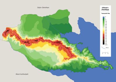
Hamidiye is divided into three distinct physiographic regions: the eastern delta (32% of the country), the Hamidian Mountains (39% of the country - 6% sometimes considered as the coastal plain), and the Hafiyeh (western) plain (29% of the country).
The eastern delta is rich with arable land adjacent to the Kilinc River. The river is a wide, supporting much of the nation. One island is present at the mouth of the river.
The Hamidian Mountains stretch across the whole country and to the seashore in the south eastern parts of the country. The shore is narrow, with importance given to the mountains for cultural reasons. Multiple peaks can be found in the range, with the most important one being Mount Aşani at an elevation of 1,049 meters. The highest peak is at the northern part of the peak, Cebel-i Taşbala, at 1,066 meters above sea level. In the south of the country, the coast is the widest in the range. This shore is sometimes considered as the forth coastal plain physiographic region. Two islands can be found on the shore of the mountain range which played an important role in the history of the country.
The Western plain ranges from the mountain range to the bordering Câf River in the south, which was historically a connection line between the Demirhan Empire and the rest of the western world.
Topography
The territory of Hamidiye is defined by the prominent central mountain range that extends in an east–west direction across the country. This highland region forms the dominant geographical feature of the nation and reaches elevations exceeding 800 metres above sea level, with the peak, Taşbala Peak, being at the far-north-west of the country at 1066 meters above sea level. These mountains create a natural barrier that historically influenced settlement patterns, transportation routes, and regional identities.
Surrounding the highlands are zones of moderate elevation, including foothills and plateaus that range between 400 and 600 meters. These areas gradually give way to lower-lying plains and coastal regions, particularly in the northeast and southeast, where elevations fall below 100 meters. The southern and eastern coastlines are marked by fertile plains and river deltas, allowing for favourable conditions for agriculture and population density.

Several river systems originate in the central mountains and flow toward the coasts, contributing to the formation of fertile valleys and supporting both irrigation and settlement. The northern interior consists of broad, forested lowlands and rolling hills, which transition into neighboring regions. The main river flows from Demirhan up until the south on the eastern side of the map and is the main source of drinking water for Hamidiye.
The stark contrast between the mountainous interior and the surrounding lowland plains results in distinct ecological and climatic zones across the country. The topography has historically played a significant role in shaping the political, economic, and cultural development of the region.
Coastal Features
The coastline of Hamidiye spans the country's eastern and southern frontiers, encompassing a diverse range of topographical and ecological features that have historically influenced the region's settlement patterns, economic activity, and maritime strategy. From mountainous coasts to rivers and deltas, the coast plays a central role in the geography and development of the nation.
Along the eastern seaboard, the coastal plain is relatively narrow, hemmed in by the steep rise of the central highlands. Rivers descending from the mountains have historically supported pockets of agriculture and fishing communities.
The southern coastline offers a broader expanse of gently sloping lowlands, shaped by wide river basins and seasonal wetlands. This region is home to the Gulf of Sultan Suleiman, a wide and sheltered bay that supports several towns. The climate here is milder and more humid, contributing to the area's agricultural productivity.
At the southeastern tip of the country lies the Demirhan Peninsula, a geologically distinct region marked by low hills, dense coastal vegetation, and a network of natural inlets. The peninsula’s strategic location has made it the site of the Hamîdiyye Capital.
Plains and Valleys
More than 65% of Hamidiye can be considered as generally flat with the remaining 35% comprising of mid to highly steep mountains. The lowlands are defined by a network of fertile plains and river valleys that radiate outward from the central mountain range. These regions, contrasting with the highlands, have historically formed the agricultural and demographic heartlands of the country.
The most prominent valley, the Hafiyeh Valley, is located south of the central highlands. Unlike other fertile regions nourished by major river systems, the Hafiyeh Plain is sustained by a network of seasonal streams and ephemeral runoff from the surrounding highlands, which carries seasonal meltwater from the mountains and deposits nutrient-rich sediments across the plain. As a result, the plain has a semi-arid character, with large areas depending on groundwater wells and seasonal irrigation systems for cultivation. Despite its dryness, the soil in the Hafiyeh Plain is mineral-rich and highly suitable for dry farming, especially the cultivation of wheat, barley, chickpeas, and sunflowers. The region’s openness and relatively flat terrain have also made it ideal for livestock grazing, particularly sheep and goats. Scattered settlements in the area are traditionally built around seasonal water points and often feature communal granaries and cisterns dating back to the 20st century. The region also serves as a crucial transportation corridor between the mountainous interior and southern coastal ports.
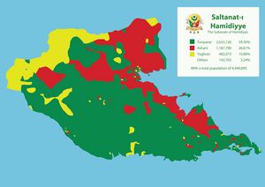
To the east, the terrain gradually lowers into the Kilinç Basin, a gently sloping area leading toward the Bay of Sultan Suleiman. Known for its mild, humid climate and rich loamy soil, the basin supports orchards, vineyards, and mixed farming. The basin's geographic isolation—protected by surrounding hills—has contributed to the preservation of distinct architectural styles and regional dialects, making it a noted center of local cultural heritage; especially for the Aşani and Yughuts population.
Natural Hazards
Due to its varied topography and climatic diversity, Hamidiye is subject to a range of natural hazards that vary significantly by region. These hazards have shaped settlement patterns, infrastructure development, and state disaster management policies throughout the country's modern history. The central mountain range, with its steep slopes and active fault lines, is particularly prone to earthquakes and landslides. The region experiences moderate to strong seismic activity, especially along the Kuzverî Fault Zone, which has been the source of several historical tremors, including the 1316 Nurşehr Quake. Landslides and rockfalls are common in high-altitude passes, particularly during spring thaw and heavy rain events.
In Hafiyeh Valley, seasonal droughts pose a significant risk to agriculture and water availability. The reliance on seasonal runoff and shallow aquifers means that fluctuations in winter snowfall and spring rainfall can lead to water scarcity and reduced crop yields. Flash flooding sometimes occur during sudden storm events, overwhelming poorly developed drainage systems in rural areas.
The eastern and southern coastal regions, are vulnerable to coastal storms and flooding. Though the region does not lie in a tropical cyclone zone, strong windstorms and localized surges occur periodically, especially during transitional seasons.
In the northern interior valleys, forest fires are an emerging hazard during dry summers. Rising temperatures and increasing vegetation stress have contributed to a noticeable rise in fire outbreaks in recent decades, prompting the establishment of regional forest monitoring programs.
The government of Hamidiye maintains a centralized Disaster Preparedness Authority, coordinating early warning systems, emergency response units, and civil defense training.
Hydrology
The hydrology of Hamidiye is shaped by its mountainous interior, semi-arid lowlands, and coastal plains, resulting in a varied network of seasonal rivers, streams, and coastal drainage basins. While the country lacks large navigable rivers; with the exception of the Kılınç River, its smaller watercourses play a vital role in agriculture, settlement, and seasonal migration patterns.
The majority of rivers originate in the central highlands, where winter snowfall and spring meltwater feed short but steep drainage systems. The most prominent among these is the Câf River, which flows for the whole border of Alora. Although the river is seasonal, peaking during spring thaw, its basin supports a network of qanat-style irrigation canals. These channels continue to provide water for dry farming and pasture rotation in the southern interior.
On the eastern slope of the mountains, rivers are shorter but more consistent due to maritime influence. Multiple smaller rivers drain into Sultan Suleriman Bay, carving out a narrow coastal plain that supports vineyards, orchards, and wetland habitats.
The north-eastern valleys, including the Kılınç River basin in the Nehr-i Kılınç Provicnce, receive higher annual rainfall and host the largest river in the country. with an average of 500 meters river, this river was used for navigation and is the most important source for water in Hamidiye
Lakes are rare in Hamidiye; most inland water bodies are seasonal marshes or man-made reservoirs created for irrigation and flood control.
Climate
Hamidiye features a diverse range of climate zones influenced by its complex topography, mountain barriers, and proximity to the sea. The country’s elevation gradient, from coastal lowlands to alpine highlands, creates significant local variation in temperature, precipitation, and seasonality.
The eastern and southeastern coastal regions, including the Ashani Bay and the Demirhan Peninsula, experience a Mesembric climate, with warm, humid summers and mild, wet winters. These areas receive the highest annual precipitation, particularly during the spring and autumn, supporting diverse agriculture such as olives, citrus, and vineyards.
In contrast, the Hafiyeh Valley exhibits a semi-arid steppe climate, with hot, dry summers and cool, relatively dry winters. Due to its location in the rain shadow of the central mountain range, this region depends on seasonal rainfall and groundwater for agriculture. Droughts and irregular precipitation are common, requiring traditional and modern irrigation techniques.
The central highlands are characterized by a montane climate, with cool summers, cold winters, and substantial snowfall. Elevations above 1,400 meters experience regular frost and snow accumulation during the winter months. These areas form a vital source of meltwater for downstream rivers during the spring thaw.
To the north, the Kılınç Basin lie in a temperate humid continental zone, with four distinct seasons and a higher annual rainfall than the central plain. Dense forests in the north and moderate temperatures make these regions important for timber production and biodiversity conservation.
Microclimates are common throughout the country, especially in enclosed valleys, coastal headlands, and interior basins, where factors such as elevation, wind exposure, and water availability significantly alter local conditions.
Biodiversity
Hamidiye hosts a rich and varied biodiversity due to its wide range of ecosystems, elevations, and climatic zones. The country’s natural landscapes—ranging from alpine highlands and humid coastal plains to semi-arid steppes—support numerous endemic species, migratory habitats, and ecological corridors.
Flora
The northern valleys and Kılınç Basin are dominated by temperate broadleaf and mixed forests, with species such as oak, hornbeam, and wild cherry, as well as medicinal plants used in traditional herbal medicine. The Demirhan Peninsula, due to its mild maritime climate, supports Mesembric vegetation including olive groves, laurel forests, and coastal scrublands rich in aromatic herbs.

In the Harbiyeh Valley, vegetation is adapted to semi-arid conditions. Here, drought-tolerant grasses, wild cereals, and sun-loving shrubs form part of a mosaic landscape shaped by rotational grazing and seasonal cultivation. Ephemeral wildflowers bloom after spring rains, attracting pollinators and migratory birds.
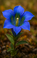
The alpine regions of the central highlands are home to subalpine meadows, coniferous patches, and high-altitude flora including Edelhamîd (Gentiana alpina hamidiya), a highland gentian found only in this region.
Fauna
The country is home to a diverse range of fauna, including lynx, red deer, wild boar, and Turquese leopard in its forested and mountainous areas. A protion of the northern valley in particular has been designated a Biosphere Corridor due to its significance for large mammal migration.
Conservation
Despite a history of deforestation and overgrazing in some regions, recent decades have seen a rise in biodiversity conservation efforts. Several national parks, including Cezîre-i Hamîdiyye Protected Zon and the Sultan Suleiman Bay Wetlands Reserve, have been established to preserve sensitive habitats. The government has also promoted community-based conservation and eco-agroforestry zones as part of sustainable development in rural areas.
Government and Politics
Administrative Divisions
 | |
|---|---|
| Administrative divisions of Hamidiye | |
| First-level | 5 provinces (vilâyetler |
| Second-level | tbd counties (sancâklar) |
| Third-level | tbd districts (kazalar) |
| Fourth-level | tbd parishes (nevâhi) |
Largest cities | |
| • Hamîdiyye • Hümayunşehir • Melîkiye • Nurşehr • Harbköy | 750,000 330,000 240,000 200,000 150,000 |
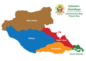
Hamidiye is divided into 4 provinces (Vilâyet) with Darü’s-Saltanat being the capital Vilayet, and the center for the Parliament. The advisory Imani Council is in the city of Hamîdiyye falling in the same province with secondary Councils in each Vilayet. The 4 provinces are divided into counties (Sancâk) which are divided into several municipalities (Kariye). Some municipalities are divided into distinct neighborhoods especially in cities.

| Code | Governorate Name | in Mazanic Hamidian (ولاية) | Postal abbrev. |
Governorate Capital | Area (km2) | Population | Pop.
Density |
|---|---|---|---|---|---|---|---|
| 1 | Darü’s-Saltanat∈⊾ | دار السّلطنت | DST | Hamîdiyye | 273.7 | 1,050,320 | 3,837.5 |
| 2 | Dergâhgâh∈⊾ | درگاهگاه | DGG | Dergâhgâh | 1542.8 | 570,000 | 369.46 |
| 3 | Cebel-i Aşan∈⊾ | جبل اشان | CAS | Nurşehr | 1235.2 | 470,000 | 380.51 |
| 4 | Nehr-i Kılınç∈⊾ | نهر كلينچ | NKL | Hümayunşehir | 5,099.3 | 1,390,375 | 272.66 |
| 5 | Hafiyye∈⊾ | خفيه | HFY | Melîkiyye | 4,536.8 | 960,000 | 211.6 |
Largest Cities
Foreign relations
Military
Law enforcement
| Government of Hamidiye | |
|---|---|
| Unitary parliamentary constitutional monarchy | |
| Capital | Hamîdiyye |
| Head of state | |
| • Sultan | Mehmed VI |
| • Grand Vizier (Sadr-ı Azam) | Furkan Rifaylı |
| Legislature | General Assembly (Meclis-i Umumî) |
| • Upper house | Imperial Assembly (Dîvân-ı Hümayun) |
| • Lower house | Assembly of Notables (Meclis-i Âyân) |
Executive Branch
Legislative Branch
Judicial System
Human rights
Economy
 | |
|---|---|
| Economy of Hamidiye | |
| Mixed economy | |
| Currency | Hamidian Akçe |
| Monetary authority | The Hamidian Treasury (Beytü’l-Mâl-i Hamîdiyye) |
Tourism
Agriculture and fishery
Agriculture
Fishing
Industry and services
Science and technology
Infrastructure
| Infrastructure of Hamidiye | |
|---|---|
| Roadways | |
| • Driving side | Right |
| • Minimum age | 16 (motor vehicles) |
| • Maximum speed | Motorway: 120km/h Urban dual: 70 km/h Rural: 90 km/h Urban: 55 km/h |
| Railways | |
| • Passing side | Right |
| • Gauge | 1435mm |
| • Electrification | Varies |
| Mains electricity | 230 V, 50 Hz |
| Telephone code | +255 |
| Internet TLD | .hy |
Energy
Transport
Demographics

| Demographics of Hamidiye | |||||||||||||||||||||
|---|---|---|---|---|---|---|---|---|---|---|---|---|---|---|---|---|---|---|---|---|---|
| Demonym | Hamidian | ||||||||||||||||||||
| Official languages | Hamidian Turquese | ||||||||||||||||||||
| Recognized minority languages | Turquese, Aşani, Yughut | ||||||||||||||||||||
Ethnicities | |||||||||||||||||||||
| |||||||||||||||||||||
Religion | |||||||||||||||||||||
| |||||||||||||||||||||
| Literacy | |||||||||||||||||||||
| Life expectancy | |||||||||||||||||||||
| Birth rate | TBD | ||||||||||||||||||||
| Death rate | TBD | ||||||||||||||||||||
Languages
Religion
Education
Health
Culture
Art and architecture
Literature and philosophy
Performing arts
Media
Holidays
Cuisine
Sports
See also
References
| Template:Hamîdiyye | |
| View on map | |
| Neighbors | |
|---|---|
| Membership | Assembly of Nations, Association of South Ulethan Nations, Imani Council |
| Global topics | Airports • Businesses • Currencies • Driving side • Electricity • Intergovernmental organizations • Languages • Rail transport |

