Infrastructure in Demirhan Empire
Demirhan Empire, spanning over half million of square kilometers has relatively well developed transportation system on land, sea and in the air.
Roads
All state roads in Demirhan Empire are toll-free. They can be divided into four categories:
- Motorways (Otoyolları, numbered Oxx) connect main cities of the country and are most suitable for long distance transportation with allowed speed up to 130 km/h.
- Express ways (Hızlı yolları, numbered Dxxx) are supporting system to motorways. All crossings are grade separated but the distance between interchanges is smaller than in case of motorways. These roads have also smaller curve radii and less roadside infrastructure. Another case where express ways may appear are unfinished motorways or short city bypasses. As a consequence maximal allowed speed is only 130 km/h.
- State roads (Devlet yolları, numbered Dxxx) the oldest system of roads dedicated to for motorized travel, mainly developed in first half of previous century before fast travel roads became more popular. State roads still remain main connection to smaller cities across the country. The max speed allowed at these or lesser roads is 90 km/h.
- Province roads (İl yolları, numbered Dx-xxx) are less important roads which connect small towns between each other. They also serve the purpose of main roads in bigger cities.
Numbering system

All roads except for motorways have first digit of number given according to zones in which the road starts:
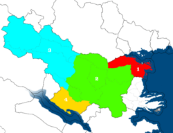
- Coastal areas of the Ivorian Sea and along Kıran rivers.
- Core of Karadolu Valley.
- Malesorian Vilayet, Yevercin Plateau, Kan and Kuru Valleys,
- Shirvan.
- Empty, kept as a reserve for mainland roads.
- Overseas territory of Şneldorf.
- Overseas territory of Tarephian Khedivate.
Additionally roads going from north to south generally have uneven numbers and those from east to west have even ones. Also in the zones lower numbers tend to be located in northeast and higher in southwest but over time arose many exceptions to the rule caused by increased by number of main roads and motorways and express ways construction.
Railways
First railway, connecting Tarsınar with Ardeşehir was opened in 1860s. Since then many other were constructed, mainly for needs of cargo transportation, therefore mining regions have the railway system significantly more developed than the rest of the country.
All of the railways of the main system use standard gauge (1435 mm) and voltage of 25 kV. There are, however some railways of local meaning which use metre gauge and lower voltage.
Rapid railways
In 1997 the proposal of construction of railway rapid transit in Demirhan Empire was given by the sultan. In 1998 first actual plans were laid down and year later the consortium of nearly 60 companies, called DemRay Construction was established, marking the start of construction of first railway between Ardeşehir and Neril has begun.
The basic premises of Demirhan Rapid Railways included: the max speed of 200 to 250 km/h, minimal curve radius of 2000 m and voltage of 25 kV. The trains were constructed by state-owned company called Vehikar.
Currently three railways are in operation:
- Malesorian border/Almıros - İskenderiya - Ardeşehir - Malazıt - Kandil - Aheron - Beril with branches to Hörezöy and Viktorya.
- Ardeşehir - Vıralmanaz - Tarsınar - Karsun - Kayramtor - Gadıvar (Denglikar) - Nehirhisar.
- Neril - Vilosetra - Kendarıl - Tarsınar.
- Malazit - Vıralmanaz - Tarsınar.
Additionally one line is planned:
- Tarsınar - Burhane - Şirvandar - Hosrat.
Some of these railways, for example line between Kabalanya and Kayramtor are also used by normal speed trains.
Ports and water ways
Demirhan Empire has access to Ivirian Sea. Main ports are located in Ardeşehir and Malazıt with other important ports including Almıros, İskenderiya, Hörezöy, Viktorya and Sebesta.
Additionally the country has access to inland Emerald Sea where cargo and passenger transportation is also present although these ports, located in Hosrat, Rudafşar and Şahriz are significantly smaller than those leading to the open sea.
Some waterways, including Kıran river up to Nehirhisar and Yenik river to Zaray Lake are suitable for inland sailing. These two rivers are also connected through canal leading from Zaray Lake through Ladiç river.
In Demirhan Tarephian Khedivate largest ports include Yeşilkörfez, Fıstıkşehri, Kumırt'uku and Şirinabad. Rohodyablo river and it's subsidiaries play crucial role in inland transportation for several towns located in the jungle.
Air transportation
 See also: Index of airports
The empire has 13 commercial airports, however the country limits air freedoms significantly to promote national company called Demirhan Airlines. Therefore flights between Demirhan Empire and another country cannot be provided by airlines located in third party country, except for three major airports in Ardeşehir, Nehirhisar and Tarsınar, and foreign airlines can not provide internal flights at all.
The country does not have civil aircraft producer and leans entirely on foreign production, mainly Sabbalini-Hordiyenko planes. Historically the empire was a major airship producer, thanks to Althaymer company. However due to lowering popularity of that type of aircraft during 40s of the previous century, the company almost entirely switched to production of civil and military drones. Although Althaymer still produces small number of airships, mainly for advertising and touristic purposes and their management tries to promote use of that mean of transportation for regular traffic as being much more environmentally friendly than planes, there is little interest for that in the international community.
| Administrative divisions • Economy • Government, politics, and international relations • Infrastructure • View on map | |
| Neighbors | Antharia, Qennes Malesoria, Kushya, Arya, Arbutania, Eden |
|---|---|
| Membership | Association of South Ulethan Nations |
| Global topics | Airports • Businesses • Currencies • Driving side • Electricity • Intergovernmental organizations • Languages • Rail transport |