User:Brunanter/Notepad
Brunanter's notepad of things.
FS-1 exit list
| County | Location | Exit | mi | km | Destination |
|---|---|---|---|---|---|
| Pinault | Chapman | 1 | 0.2 mi | 0.33 km | Frontier St. Chapman downtown North Frontier St. Trincheras |
| 2 | 0.78 mi | 1.26 km | Sepulveda Street | ||
| 3 | 2.62 mi | 4.23 km | East Bonanza Avenue | ||
| 3A | 3.51 mi | 5.66 km | Altamira Street | ||
| 4 | 4.63 mi | 7.45 km | |||
| 4A | 5.63 mi | 9.07 km | Chapman Port of Entry | ||
| 4B | 7.19 mi | 11.57 km | I-108/CR-1 | ||
| 5 | 11.43 mi | 18.41 km | I-108/CR-1 (west) S-13/CR-5 (east) | ||
| Bilton | 6 | 15.21 mi | 24.49 km | S-1 | |
| 7 | 17.02 mi | 27.39 km | S-13, I-108/CR-3 | ||
| 8 | 19.56 mi | 31.48 km | S-1 | ||
| 9 | 24.39 mi | 39.25 km | CR-7, Hopkins | ||
| 10 | 30.94 mi | 49.79 km | CR-2 | ||
| Juana Peña | 10A | 36.77 mi | 59.18 km | CR 3 | |
| Drummond | 11 | 39.74 mi | 63.95 km | CR 3 (west) S-1/Main Street (east) | |
| 12 | 41.38 mi | 66.6 km | I-115/CR 1 | ||
| 13 | 42.36 mi | 68.18 km | S-1/Main Street | ||
| 13A | 47.51 mi | 76.46 km | CR 5 | ||
| 14 | 55.86 mi | 89.91 km | Juana Peña Rest Area | ||
| Benoit | 15 | 64.2 mi | 103.32 km | CR 2 (west) S-1/CR 2 (east) | |
| Pink | 16 | 66.17 mi | 106.49 km | I-113/CR 4, Hernandez (north) I-113/CR 4, Silverdale City (south) | |
| 17 | 74.17 mi | 119.36 km | I-111/CR 3, Hernandez (north) I-111/CR 3, Cannon City (south) | ||
| 18 | 78.31 mi | 126.03 km | S-1/CR 2 | ||
| 18A | 82.44 mi | 132.68 km | |||
| 19 | 88.13 mi | 141.83 km | S-1 | ||
| 20 | 92.38 mi | 148.67 km | S-1 | ||
| Selman | 21 | 96.54 mi | 155.36 km | ||
| 22 | 98.59 mi | 158.67 km | S-1 | ||
| 23 | 104.82 mi | 168.7 km | Minnow Road | ||
| 24 | 109.44 mi | 176.13 km | Barclay (north) Henderson/airport (south) | ||
| Henderson | 25 | 112.28 mi | 180.7 km | Barclay (north) Henderson/airport (south) | |
| 26 | 113.47 mi | 182.61 km | FS-480/Henderson Parkway | ||
| 27 | 116.18 mi | 186.98 km | Southern Avenue Henderson/Dennison | ||
| Dennison | Dennison | 28 | 117.36 mi | 188.88 km | Veterans Parkway |
| 28A | 118.07 mi | 190.02 km | Fulton Drive Southwest | ||
| 29 | 118.48 mi | 190.68 km | Southwest Folsom Street | ||
| 30 | 119.06 mi | 191.61 km | Nickerson Street | ||
| 30A | 119.71 mi | 192.67 km | San Carlos Avenue | ||
| 31 | 120.19 mi | 193.43 km | Lewis Street | ||
| 32 | 120.98 mi | 194.71 km | Graham Street | ||
| 33 | 122.04 mi | 196.41 km | Spinola Street | ||
| 34A/B | 122.65 mi | 197.38 km | FS-160 (east), FS-81 (north) | ||
| 35 | 123.17 mi | 198.22 km | East Barrett Drive | ||
| 36 | 124.14 mi | 199.79 km | Southern Avenue | ||
| Meseta | Redonda | 37 | 125.53 mi | 202.02 km | Corona Avenue |
| 38A/B | 126.55 mi | 203.67 km | June Avenue | ||
| 39A/B | 127.78mi | 205.64 km | Villa Road | ||
| 40A/B | 128.84 mi | 207.35 km | Henderson Parkway/FS-480 | ||
| 41 | 130.1 mi | 209.38 km | Sorrent (west) Dennison International Airport (east) | ||
| 42 | 131.98 mi | 212.4 km | |||
| 43 | 133.66 mi | 215.11 km | |||
| 43A | 139.43 mi | 224.4 km | Mile 139 Rest Area | ||
| 44 | 133.66 mi | 215.11 km | Fountainhead | ||
| 45 | 148.25 mi | 238.58 km | |||
| Elvira | 46 | 151.94 mi | 244.53 km | Elvira Regional Airport | |
| 47 | 154.68 mi | 248.94 km | Wallace Avenue/Hernandez Street | ||
| 47A | 155.69 mi | 250.56 km | Pueblo Avenue | ||
| 48 | 156.4 mi | 251.71 km | Fulbright Street | ||
| 49 | 157.05 mi | 252.75 km | FS-1/FS-81 split | ||
| 50 | 157.46 mi | 253.41 km | Franklin Avenue | ||
| 51 | 158.1 mi | 254.43 km | Pueblo Avenue | ||
| 52 | 158.67 mi | 255.36 km | Bell Avenue | ||
| 53 | 159.83 mi | 257.23 km | Vereda Street | ||
| 53A | 161.13 mi | 259.31 km | Sadie Travel Center | ||
| 53B | 162.41 mi | 261.38 km | Runaway truck ramp | ||
| 54 | 163.3 mi | 262.81 km | |||
| 54A | 165.3 mi | 266 km | Runaway truck ramp | ||
| 55 | 165.5 mi | 266.35 km | Elvira River Open Space | ||
| 56 | 168.32 mi | 270.88 km | S-6 | ||
| 57 | 171.21 mi | 275.54 km | Runaway truck ramp | ||
| 58 | 172.45 mi | 277.54 km | Lewiston Rest Area/Lewiston | ||
| 58A | 176.18 mi | 283.54 km | Ballard Chain Station | ||
| Ballard | 59 | 180.53 mi | 290.53 km | Howards Street | |
| 59B | 183.79 mi | 295.78 km | Runaway truck ramp | ||
| 59A | 184.7 mi | 297.25 km | Jones Mine/Ballard Mine | ||
| 59C | 188.4 mi | 303.2 km | Weigh station | ||
| Harding | 60 | 197.79 mi | 318.32 km | CR-15 | |
| Estancia | 60A | 202.94 mi | 326.6 km | Upper Fulbright Rest Area | |
| 60B | 203.72 mi | 327.85 km | |||
| Clearwood | 61 | 211.71 mi | 340.73 km | ||
| 62 | 216.47 mi | 348.38 km | |||
| 62A | 219.32 mi | 352.97 km | Mount Silver Rest Area | ||
| 63 | 226.51 mi | 364.54 km | |||
| 63A | 228.75 mi | 368.14 km | |||
| Kaitenas | 64 | 231.65 mi | 372.81 km | ||
| Limones | 65 | 239.64 mi | 385.67 km | ||
| 65A | 245.65 mi | 395.34 km | Sangre Mountains Rest Area | ||
| 66 | 253.13 mi | 407.38 km | |||
| San Daniel | 67 | 258.66 mi | 416.28 km | ||
| 68 | 259.69 mi | 417.94 km | I-103/CR-1 Big Vista (couth) | ||
| Cherry Valley | 69 | 266.12 mi | 428.28 km | ||
| 70 | 270.62 mi | 435.52 km | |||
| 71 | 277.34 mi | 446.34 km | |||
| 72 | 278.40 mi | 448.05 km | Runaway truck ramp | ||
| 72A | 281.8 mi | 453.52 km | Runaway truck ramp | ||
| La Rue | 72B | 289.04 mi | 465.17 km | ||
| 73 | 291.44 mi | 469.03 km | |||
| 74 | 294.77 mi | 474.39 km | |||
| Nowhere | 75 | 300.58 mi | 483.74 km | ||
| 76 | 306.43 mi | 493.16 km | Eastern Sierras Rest Area | ||
| 77 | 312.67 mi | 503.2 km | Gamble Port of Entry | ||
| Gamble | 78 | 313.59 mi | 504.68 km |
FS-80 exit list
| County | Location | Exit | mi | km | Destination |
|---|---|---|---|---|---|
| Serrano | North Dennison | 1 | 0 mi | 0 km | Colurona Parkway |
| 2 | 0.57 mi | 0.91 km | North Rosas St | ||
| 3 | 1.94 mi | 3.12 km | McCartney Street | ||
| 4 | 3.93 mi | 6.32 km | Santana Street | ||
| 5 | 7.99 mi | 12.86 km | Urbino Road | ||
| 5A | 9.28 mi | 14.94 km | Runaway Truck Ramp | ||
| 6 | 11.48 mi | 18.47 km | Chain Station/Posada Rest Area | ||
| Posada | 7 | 16.83 mi | 27.08 km | Posada | |
| 8 | 22.62 mi | 36.40 km | Las Mesetas Road | ||
| 9 | 39.77 mi | 64.01 km | Spearmint Butte Road | ||
| 10 | 48.51 mi | 78.07 km | S-10 | ||
| Hayes | 11 | 54.22 mi | 87.27 km | Vera Street | |
| Tabache | 12 | 58.53 mi | 94.19 km | S-10 | |
| Timona | 13 | 61.37 mi | 98.77 km | S-10/Tabache Road | |
| Kena | 14 | 64.13 mi | 103.20 km | S-10 | |
| Andaguani | 14C | 69.45 mi | 111.77 km | McInnes Rest Area | |
| Estancia | 14A | 70.04 mi | 112.71 km | Sanchez Tunnel Service/overheight | |
| 14B | 71.94 mi | 115.78 km | Sanchez Tunnel Service/overheight | ||
| 14D | 72.34 mi | 116.42 km | Runaway Truck Ramp | ||
| Guerrero | 15 | 76.88 mi | 123.72 km | S-10/CR-5 | |
| 16 | 80.69 mi | 129.85 km | Main Street | ||
| 17 | 84.18 mi | 135.48 km | S-10 | ||
| Andaguani | 18 | 97.44 mi | 156.82 km | CR-1 | |
| 19 | 117.64 mi | 189.32 km | Parris Rest Area | ||
| 20 | 124.52 mi | 200.39 km | Runaway Truck Ramp | ||
| 20A | 127.03 mi | 204.44 km | Chain Station | ||
| 21 | 133.89 mi | 215.49 km | Belmont Road | ||
| Forrester | 22 | 141.26 mi | 227.35 km | Main Street | |
| 22A | 154.81 mi | 249.14 km | Sadie Travel Center | ||
| Cartman | 23 | 168.16 mi | 270.62 km | Main Street | |
| 24 | 171.30 mi | 275.68 km | Welcome Center | ||
| 25 | 179.35 mi | 288.64 km | Cartman Port of Entry |
FS-81 exit list
| County | Location | Exit | mi | km | Destination |
|---|---|---|---|---|---|
| Dennison | Dennison | 1 | 0 mi | 0 km | Altiplano Parkway/Spicer Avenue |
| 2 | 0.18 mi | 0.29 km | |||
| 3A/3B | 0.87 mi | 1.4 km | |||
| 4A/4B | 1.84 mi | 2.97 km | |||
| 5A/5B | 2.34 mi | 3.76 km | |||
| 35 | 2.9 mi | 4.67 km | East Barrett Drive | ||
| 36 | 3.87 mi | 6.23 km | Southern Avenue | ||
| Meseta | Redonda | 37 | 5.13 mi | 8.25 km | Corona Avenue |
| 38A/B | 6.16 mi | 9.91 km | June Avenue | ||
| 39A/B | 7.42 mi | 11.94 km | Villa Road | ||
| 40A/B | 8.44 mi | 13.58 km | Henderson Parkway/FS-480 | ||
| 41 | 9.7 mi | 15.62 km | Sorrent (west) Dennison International Airport (east) | ||
| 42 | 11.58 mi | 18.64 km | |||
| 43 | 13.26 mi | 21.34 km | |||
| 43A | 19.03 mi | 30.63 km | Mile 139 Rest Area | ||
| 44 | 23.46 mi | 37.75 km | Fountainhead | ||
| 45 | 27.51 mi | 44.28 km | |||
| Elvira | 46 | 31.55 mi | 50.77 km | Elvira Regional Airport | |
| 47 | 34.29 mi | 55.18 km | Wallace Avenue/Hernandez Street | ||
| 47A | 35.16 mi | 56.59 km | Pueblo Avenue | ||
| 48 | 35.9 mi | 57.78 km | Fulbright Street | ||
| 49 | 36.52 mi | 58.78 km | FS-1/FS-81 split | ||
| 50 | 40.59 mi | 65.32 km | |||
| 50A | 45.76 mi | 73.64 km | Sadie Travel Center | ||
| 51 | 49.82 mi | 80.18 km | |||
| Fort Nickerson | 52 | 60.12 mi | 96.75 km | ||
| 53 | 70.52 mi | 113.49 km | |||
| Braxton | Lola | 54 | 71.91 mi | 115.73 km | Northeast Alameda de la Colurona |
| 55 | 73.71 mi | 118.62 km | Las Vegas Avenue | ||
| 56 | 76.49 mi | 123.1 km | I-102/CR-10 | ||
| 57 | 77.67 mi | 125 km | CR-1/RTC | ||
| Meseta | 57A | 82.49 mi | 132.75 km | ||
| Brenton | Casa Grande | 58 | 88.11 mi | 141.8 km | |
| 59 | 95.72 mi | 154.04 km | |||
| Royston | 60 | 109.54 mi | 176.3 km | ||
| 61 | 112.77 mi | 181.49 km | |||
| 62 | 128.56 mi | 206.9 km | |||
| 62A | 139.67 mi | 224.78 km | |||
| Montillo | 63 | 146.61 mi | 235.94 km | ||
| 64 | 148.49 mi | 238.97 km | |||
| 65 | 150.28 mi | 241.86 km | |||
| 66 | 159.05 mi | 255.96 km | Paige, Cable Creek | ||
| 67 | 164.67 mi | 265.02 km | Welcome Center | ||
| 68 | 165.35 mi | 266.11 km | Montillo Port of Entry |
Caracan creole dictionary (Diksionè kriol karak)
- ajou - now (en), maintenant (fr)
- anfan(s) (see tipetì) - child(ren) (en), enfant(s) (fr)
- anfomasion - information (en, fr)
- arjan - money/cash (en), argent (fr)
- auto (see kar) - car (en), auto/voiture (fr)
- bank - bank (en), banque (fr)
- bua - wood (en), bois (fr)
- chaktan - each time (en), chaque temps (fr)
- che - to, at, in or into the home (en), chez (fr)
- dan - in (en), dans (fr)
- diksionè - dictionary (en), dictionnaire (fr)
- draivè (alt. kondisè) - to drive (en), conduiser (fr)
- egliz - church (en), église (fr)
- etè - summer (en), été (fr)
- fan - woman (en), femme (fr)
- fe - made (en), fair (fr)
- frè(s) - brother(s) (en), frère(s) (fr)
- frua - cold (en), froid (fr)
- gasupè (alt. ranpli vèk gazolin) - to gas up (en), faire le plein (fr)
- gazolin - gasoline, petrol (en), essence (fr)
- jou - to play (en), jouer (fr)
- kar (see auto) - car (en), auto/voiture (fr)
- Karak - Caraque (en, fr)
- ki - who (en), qui (fr)
- koko - coconut (en), coco (fr)
- kombien - how much (en), combien (fr)
- konpitè (alt. odinatè) - computer (en), ordinateur (fr)
- kriol - creole (en), créole (fr)
- kuizin - kitchen, cuisine (en), cuisine (fr)
- lan/lanman - slow/slowly (en), lent/lentement (fr)
- lautobus - bus (en), autobus (valonian)
- lil - island (en), île (fr)
- lo - water (en), eau (fr)
- lokoko - coconut water (en), l'eau de coco (fr)
- manje - eat/to eat (en), mange/manger (fr)
- me - but (en), mais (fr)
- mezon - house/joujou temple (en), maison/temple joujou (fr)
- muan - my/mine (en), mon/ma (fr)
- nou - us (en), nous (fr)
- pa - no/none (en), pas (fr)
- pal - talk/to talk (en), parle/parler (fr)
- payè - to pay (en), payer (fr)
- pier - stone/rock (en), pierre (fr)
- pliz - more/additional/plus (en), plus (fr)
- po - for (en), pour (fr)
- pran - to take, get (en), prend (fr)
- refrechi - refreshes (en), rafraîchit (fr)
- ridè - to ride (en), monter, rouler (fr)
- Sanjan - Saint John (en), Saint-Jean (fr)
- se - it is/is it (en), c'est (fr)
- sè(s) - sister(s) (en), soeur(s) (fr)
- selfon (alt. telfon mobil) - cellphone, mobile phone (en), téléphone mobile (fr)
- sevì - service (en, fr)
- sì - here (en), ici (fr)
- soup - soup (en, fr)
- sove - save (en), sauve (fr)
- tan - time/weather (en), temps (fr)
- tian - has (en), tiens (fr)
- tikè (alt. biyè) - ticket (en), billet (fr)
- tipetì (see anfan) - children (en), enfants, les tout-petits (fr)
- uazo - bird(s) (en), oiseau(x) (fr)
- vèk - with (en), avec (fr)
- vien - come (en), viens (fr)
- vou - you (formal) (en), vous (fr)
Sierra Roadside Attractions
Sierra Roadside Attractions,
| SRA Ref | Name | Location | Description |
|---|---|---|---|
| SRA001 | The Big Sierran | Gamble (Estancia County) | Large neon Sierran cowboy wearing a large western hat, built in the 1950s |
| SRA002 | Nada Bison | Nada (Elgin County) | Tall bison shaped building with lookout |
| SRA003 | The Big Dino | Dinosaur City (Andaguani County) | Large statue of a Sierraceratops |
| SRA004 | Car Pyramid | Mona (Gerrard County) | Sierran indigenous style pyramid made from old stacked cars |
| SRA005 | Welcome to Chapman Western Wonderland sign | Chapman (Pinault County) | Famous googie welcome sign to Chapman built in 1962 |
| SRA006 | The Big Cowboy Hat | Dollar City (Pinault County) | Large cowboy hat monument |
| SRA007 | Cosmic Carl (The Spaceman) | Spaceman (Zusi County) | 49.5 ft (15 m) tall statue of astronaut completed in 1966 |
| SRA008 | El Buitre UFO | El Buitre (Zusi County) | Large UFO monument near site of supposed UFO landing |
| SRA009 | The Pink Flamingo | High and Dry (Zusi County) | Building with large flamingo on top |
| SRA010 | Space Ship monument | Panaco (Zusi County) | Monument designed to represent a crash landed rocket on Space Ship Mountain |
| SRA011 | Martian of the Desert | Carrillo (Zusi County) | Attraction with supposed martian corpse discovered in the mid-1930s |
| SRA012 | Tom Stillwell's Cabin | Stillwell's Gulch (Zusi County) | Cabin Where Stillwell's gang made their last stand against Sierra rangers in 1889 |
| SRA013 | World's Greatest Llama | Ballard (Meseta County) | Large llama statue |
| SRA014 | Ruins of El Buitre Hotel | El Buitre (Zusi County) | Ruins of hotel in El Buitre ghost town |
| SRA015 | World's Biggest Potato | Elvira (Meseta County) | Large Potato statue built in 1973 |
| SRA016 | Doll of Paloma Negra | Hallsville (Timona County) | Tall statue of "creepy" indigenous woman doll |
| SRA017 | El Serrano | Braxton (Zusi County) | Tall state of a Sierran cowboy, 1950s |
| SRA018 | Chile Cafe Sign | Hey (Zusi County) | Neon sign for restaurant |
| SRA019 | Neon Rocket sign | Andaguani City (Andaguani County) | Neon sign for an old truck stop |
| SRA020 | Lopez UFO abduction monument | Carvajal (Asuma County) | Monument to Alien abduction of John and Jimena Lopez in 1970 |
| SRA021 | Meltdown Monument | Radiation Springs (Pinault County) | Mushroom cloud sculpture symbolizing the Lake Mona Generating Station partial meltdown of 1973 |
| SRA022 | Sierra Sally | Dennison | Concrete statue of a cowgirl built in 1971, symbol of Sierra's rodeo |
| SRA023 | Dennison Dan | Dennison | Concrete statue of a cowboy built in 1971, symbol of Sierra's rodeo |
| SRA024 | The Big Pickaxe | Hayes (Serrano County) | 4 m/13 ft tall pickaxe |
| SRA025 | Volcano Alley | Rosalie (Timona County) | Large concrete replicas of western FSA volcanoes built in the 80s |
| SRA026 | Fast Food Museum | Redonda (Serrano County) | Museum dedicated to fast food memorabilia located in 1960s Hiway Diner building |
| SRA027 | Sutter House (Lone Pine Murders House) | Lone Pine (Brenton County) | Haunted house known for grisly murders in 1917 and 1983 |
| SRA028 | Oldest House in Sierra | Lola (Braxton County) | Early 1800s house and shop in colonial Lola |
| SRA029 | World's Biggest Glass of Beer | San Daniel (Estancia County) | Large sculpture of a Montana beer |
| SRA030 | Museum of Extraterrestrial Life | Panaco (Zusi County) | Museum with alien/extraterrestrial artefacts |
| SRA031 | Boot Bridge | Brack (Brenton County) | Observation bridge shaped like 2 large cowboy boots |
| SRA032 | Casino Plaza∈⊾ƨ | Chapman (Pinault County) | Urban park with oversize poker chips and dice and water fountain with playing card shape |
| SRA033 | Museum of Archantana | Chapman (Pinault County) | Museum with antique FSA memorabilia, neon signs, classic cars |
| SRA034 | Denim Legs | La Rue (Estancia County) | Oversize sign of denim pants and boots advertising defunct western clothing store |
| SRA035 | FSS Iguana | Clinton (Timona County) | Great war era submarine displayed between Clinton and Braxton |
| SRA036 | Santa Paula Lighthouse | Santa Paula (Brenton County) | Lighthouse located over 188 mi/300km from nearest ocean |
| SRAXXX | Sierra's Biggest joint | La Rue (Estancia County) | Large joint (marijuana cigarette) on dispensary rooftop |
Le Jardin Hotels and Resorts
Le Jardin Resorts
- White Pearl by Le Jardin (
 Iscu)
Iscu) - Anse Cay by Le Jardin (
 Arecales)
 - Le Jardin Caraque Resort ( Arecales)
Le Jardin Hotels
Fridegall Resorts
Fridegall Hotels
ELLA Hotel
- ELLA Hotel Clifford Centennial (
 Federal States)
 - ELLA Hotel Dennison Downtown ( Federal States)
- ELLA Hotel Alamar ( Federal States)
- ELLA Hotel Andreapolis Cathedral ( Federal States)
- ELLA Hotel Sant-Fernando (
 Barzona)
 - ELLA Hotel Carante ( Barzona)
LAT Tarephian Airlines
LAT Tarephian Airlines (commonly LAT) is a Tarephian multinational airline of Teotiyolcan, Barzona and Tempeira. LAT was formed from the merger of domestic airlines/flag carriers of the respective three countries. LAT Tarephian has major hubs in Carante, Teotialtecoyan and Tiléia and secondary hubs in Barzona, Mar Agosto. It is a member of the WorldStar alliance.

Barzona timeline
Pre-1000
- 12th century BC: Conchina archeological site is occupied, oldest confirmed major settlement in Barzona
- Ca. 550 BC: Tesunhuehueche is settled by indigenous
- Ca. 400: Cavana, first major city (atepet) of Taqueza indigenous is established
- Ca. 500 Cubutacubun people begin ascendancy as a force
- Ca. 650: Canavi rises as a major power along the coast and conquers Cavana
- 840-900: Triple Cities of Teotiyolcan invade northern Barzona, making vassals and new settlements
1000-1200
- Ca. 1000: Simiqueguin is founded, najor city of Taqueza empire
- 1100-1150: Taqueza empire expands and de3feats rivals, even taking lands and cities from Triple Cities
13th century
- 1202: Sant-Miquel (Mondier Canton, Marca) is founded as first Valonian settlement
- 1223: Mondier is founded as first major town of Valonian colonial era
- 1255: Via circular, oldest roundabout in Barzona is built
- 1260-1300: Last major settlements of Taqueza, including Mestiguin, Masacuate and Allendea are built
- 1268: Bergantin Founding of Bergantin
- 1270-1275: Agreememnt of Cualutunaltac, lord of Tepuyuvi with Guy de Montdidier, Marquis of Mondier, first indigenous-Valonian alliance
- 1280: City of Barzona is founded
- 1290-1350: Taqueza and Nawat towns beging to be abandoned as Valonian expand north, bringing violence and disease
14th century
- 1300: Tecazaguin is abandoned by Taquezas, Valonian build a church on top of the great pyramid
15th century
- 1402-03: Group of knight dies during an expedition to Yavi rainforest
16th century
- 1554: Acres Castle begins construction in response to Castellanese, transitional castle between medieval and early modern fortifications
- July 1555: Juan de Torres y Mirón lands near modern day Sant-Antonio nal Mar and claims it for Castellan
- September 1555: First basttle between Valonian and Castellanese for control of Barzona
- October 1556-February 1557: Castellanese besiege and capture Barzona city
- April 1557: Francisco de las Casas y Carvajal founds the city of Carante, named after his birth town
17th century
- 1612-1615: the cacique Piquinucafuy leads Cubutacubun people in a revolt against Castellanese
- 1652: second war between Castellanese and Valonian
- 14 May 1652: Mondier is destroyed in battle and Valonian are removed from majority of Barzona. New town of Mondier is built to the south
18th century
19th century
1810s
- May 1812-1813: Mondier revolt, criollos in the city revolt against governor José María Figueroa y Blanco
- July 1812: Patriots meet
 in Taseseque in a congress, declaring the Loyalist State of Serranía but still pledging allegiance to the king of Castellan as monarch of Barzona
 - 11 August 1812: Battle of Taseseque, Patriots are defeated by royalists
- 14 October 1812: Kingdom of Barzona is declared with the King of Castellan as monarch
- January-April 1813: Siege of Fontanet and defeat of patriots
- 9 June 1817: Juan Piero Belmont and other patriots declare the independence of State of Carante, first independence of Barzona
- August 1817: Meeting of Piscua, Belmont met with Mateus Barrigan and Francisco Meléndez y Rondelet (Marquis of Mondier) to dclare nothing short of full independence and end of recognition of Castellanese monarchy
- September 1817: Barzona joins as part of Gran Fojenica
- January-May 1819: Mondier is besieged and taken by the patriots
1820s
- 8 July 1820: Siege of Fontanet
- August 1820: Start of Siege of Barzona
- 23 April 1821: Patriots enter Barzona after a long sige
- September 1821: Sant-Martin Castle surrenders, last Castellanese stronghold in Barzona
- October 1826: Colonel Manuel Lucero y Quiroz leads a revolt against the Gran Fojenican government (Lucerist revolt)
- March 1827: Lucerist revolt is put down. To address grievances of Barzonans, Count Lucio Belcamp, (Commandant General of Carante) is declared vice president of Gran Fojenica
1830s
- November 1832: Revolt by Barzonans against Gran Fojenica begins
- 26 December 1832: Battle of Sulinapa, government forces are defeated by rebels
- 30 January 1833: Rebels take Carante
- 9 June 1833: Barzona's independence is re-established as South Tarephian Republic, Mateus Barrigan is president
- 6 February 1839: Lucio Belcamp takes power in coup and declares the Republic of Barzona
1840s
- 5 April 1843: President Lucio Belcamp is assassinated
1850s
- 21 July 1855: lycene republic is declared but Barzonan president Eusebio Verrier is assassinated before treaty can be signed
- July 1855: Liberal Arthur Fontenoy takes power with support of military, establishing the United States of Barzona as a federation
1880s
- January 1889: Barzonan civil war between Conservatives and Liberals breaks out
- 14 May 1889: General Piero Esquibel takes power in coup, dissolves government, declares the second Republic of Barzona
Early 20th century
1930s
- 9 March 1930: Coup against the Paulo Artigas government, Andreus Martell serves as military president until 1939 transition of power
1940s
- Great war in the Lyc?
1950s
- 2 April 1957: President David Salas is assassinated by a dissatisfied worker
Late 20th century
1950s
- 1957: Barzona founds the Tarephian Radio Television organization (RTT), linking many national broadcasters now of the TCC
1960s
- 2 July 1960: Liberal Julian Delbonis takes power after a contentious election ending over 20 years of Conservative power
- 21 May 1965: A month before elections and his likely reelection, president Delbonis is assassinated and military junta takes power in coup, dissolving congress and suspending some rights
- November 1965: General Gabriel Passos Ricard becomes president
- 1966: Barzona hoins the Assembly of Nations
- 16 May 1968: Around 10000 protestors in Piaza nalla Republica are fired upon by army and nine are killed
- Summer 1968: Violent strikes paralize Carante, Barzona, Mondier
- March 1969: Soldier killed in drive by shooting in Carante center, old town is barricaded and highly secured for over another decade
- July 1969: Esquedra Republicana na Barzona (ERB), guerrilla group is founded
1970s
- 3 January 1970: 600 civilians and one
- 7 April 1970: FA-3 armed group bombs Guarda Civil building, injuring and killing a dozen people
- February 1971: Barzona Libre (BL) guerrilla group is founded
- 5 November 1972: Barzona army liberates town of Santa Virginia, Forzas nalla Patria paramilitaries kill 36 civilians
- May 1973: Barzonan army operations nearly destroy all of Barzona Libre's fighting capacity
- August 1973: ERB and BL leaders meet, agreeing to fight together and set up a joint command
- April 1974: The rebels' Tocarruncho offensive leads to reclaiming significant rural areas in Serrania and Yavi departments, threatening the capital and reaching as close as Cornel
- 5 October 1977: Army kills 45 students during a student protest and occupation of the {(relation|209318|National University}} in Carante
- 14 February 1978: Military and rebel groups reach an uneasy ceasefir, the St. Valentines Day Accord, civilian government of Felix Casamont is elected after 13 years of military rule
1980s
- December 1980: Barzonan conflict begins escalating again
- 3 March 1981: President Casamont is deposed in a "situational military control", leading to renewer rebel offensives against Carante
- 19 July 1982: Credibanc building in Barzona is damaged in car bomb attack by FARU, 36 killed and wounded
- 27 September 1983: Yahuizapa massacre, 39 mostly indigenous are extrajudicially killed by the army and/or paramilitiaries, suspected of supporting FARU rebels
- 11 April 1983: Federal States consulate is slightly damaged in FARU car bomb attack, nine casualties
- 7 January 1984: 8 naval cadets killed in FARU attack on their bus
- 15 September 1986: Barzona government, ex-paramilitary and members of ERB, BL and FA-3 sign and ratify final peace agreement
- 1 May 1988: Barzona joins the Tarephia Cooperation Council
1990s
- 2 February 1990: FARU leadership declares a "permanent ceasefire". Marks the end of violent conflict in Barzona
21st century
2000s
- 4 January 2005: President Lisette Masis is impeached by the government for corruption, later sentenced to 7 years in prison
2010s
2020s
- 7 December 2020: Lisette Masis is elected as president
Dennison 1964
Here is information on the Dennison Sierra bid for the II Winter Pax Nova Games. The main city for the games is Dennison, hosting the opening/closing ceremonies, ice hockey, speed skating and figure skating. Outsoor sports such as downhill skiing, cross country skiing, bobsled, biathlon and ski jump are at tyhe town of Clearwood, in central Sierra.
Most of the Dennison facilities are located in the Nova Park neighborhood. Located NE of Downtown and the urban University of Dennison campus, is likely an existing neighborhood with older housing and other buildings extensively remodelled in a mid century and brutalist style to become focal sports of the Pax Nova athletes village. Many period developments exist in the area as part as overall infrastructure construction, such as transit centers, shopping areas and more.
Despite the games being held 60 years ago, many facilities still survive, but many of the facilities/buildings have been extensively remodeled since or no longer exist. Other specific landmarks such as the cauldron, scoreboards, temporary accomodations etc no longer exist on the map.
Primary venues
| Name | Location | Games Use | Present use | Notes |
|---|---|---|---|---|
| Dennison Centennial Coliseum 3D | Nova Park | Opening/closing ceremonies, ice hockey, figure skating | Used for ice sports | Purpose built for games, mid century architecture |
| University of Dennison Ice Hockey Rink | University | Ice hockey | Demolished, replaced with a parking lot occupying the building footprint | Purpose built for games |
| Dunster Lake Speed Skating Track | Dunster Lake/Yenagant | Speed Skating | Occasional use for speed skating and roller skating | Purpose built for games |
| Clearwood Downhill Ski Center | Clearwood (Estancia Co.) | Downhill ski | Remodeled and in use as part of Clearwood Canyon Ski resort | Existing ski facilities improved for games |
| Clearwood Ski Jump | Clearwood (Estancia Co.) | Ski jump, nordic combined | Still in use | Purpose built for games |
| Clearwood Cross Country Ski Tracks | Clearwood (Estancia Co.) | Cross Country Ski, nordic combined | No longer visible on map | Pre-existing |
| Bobsled track | Clearwood (Estancia Co.) | Bobsled/luge facilities | Would have been demolished some time after the games | Purpose built for games |
| Biathlon facilities | Clearwood (Estancia Co.) | Bobsled/luge facilities | Would have been demolished some time after the games | Purpose built for games |
| Athletes Village 3D | Nova Park | Main athletes village in Dennison | Used as apartments (Nova Park and Centennial Village) | Purpose built for games, mid-century architecture |
| Alpine Athletes Village 3D | Clearwood (Estancia Co.) | Secondary Athletes Village | Used as apartment and a hotel | Purpose built for games, mid century architecture |
| Dennison Media and Broadcasting Center 3D | Nova Park | Press center | Used mainly by medical offices/clinics | Purpose built for games, brutalist/mid-century architecture |
| Media Housing | Arboledas | Housing for media personnel | Public housing | Purpose built for games |
| Clearwood Media Center | Clearwood (Estancia Co.) | Press center | Various offices | Purpose built for games |
Adjacent facilities and infrastructure
Other adjacent facilities to the games, mainly Nova Park development and other major infrastructure in Dennison and in Sierra.
| Name | Location | Description |
|---|---|---|
| Nova Plaza 3D | Nova Park | Mid-century modern shopping mall built 1959-1962 |
| Hanniman Elementary School | Nova Park | School built during neighborhood development |
| Altamonte Transit Center | Altamonte | Major public bus station built to accomodate visitors to Altamonte/Nova Park venues and amenities |
| La Senda Motel | Altamonte | Could have been built for tourist lodgings during games |
| Mogollar TV tower | Mogollar Hills | Probably built prior to the games as television was introduced in Sierra, on a hilltop near the highest point in the Dennison altiplano. |
| University | Planned freeway to have been built connecting Barclay and the FS-81. Would have been built prior to construction of winter game sites but opposition from citizens to the major demolitions of neighborhoods led to only an interchange completed. | |
| Central Sra | Not necessarily built for the games, but would have been completed in years prior to and allowed road traffic between the alpine and city venues | |
| Fulbright-Silver Regional Airport | Mount Silver (Estancia Co.) | Would have been built prior to games to allow VIP/officials to fly in to the alpine village |
| Whitehouse Mountain TV towers | Clearwood (Estancia Co.) | Built specifically to transmit the alpine sports on television |
Imagery
Logo and poster for the 1964 games bid. The logo is based off of a snow capped volcano peak, and the pax nova rings are placed to symbolize the ash erupting from a volcano. The logo and posters use Trade Gothic fonts.
-
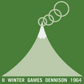 Logo for the Dennison 1964 bid
 -
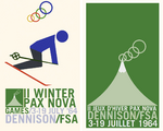 Posters for the II winter games

