Index:Provinces of Deodeca: Difference between revisions
No edit summary |
No edit summary |
||
| (8 intermediate revisions by 4 users not shown) | |||
| Line 7: | Line 7: | ||
| collapse = yes | | collapse = yes | ||
}}{{clear}} | }}{{clear}} | ||
{{htoc|Agawaskway|Ingerish Asperia|Kastichetshan|Ouanatchkan}}<!-- Please add your province in alphabetical order --> | {{htoc|Agawaskway|Ingerish Asperia|Kastichetshan|Ouanatchkan|Queen Adelaide Island}}<!-- Please add your province in alphabetical order --> | ||
{{Snapshot Deodeca province | {{Snapshot Deodeca province | ||
| Line 32: | Line 32: | ||
| img-tree = Trembling Aspen.jpg | | img-tree = Trembling Aspen.jpg | ||
| cap-tree = The provincial tree, Quaking aspen (''Populus tremuloides'') | | cap-tree = The provincial tree, Quaking aspen (''Populus tremuloides'') | ||
| img-license = | | img-license = DE-AA plate.png | ||
| cap-license = Standard license plate (2014-present) | | cap-license = Standard license plate (2014-present) | ||
| img-shield = | | img-shield = DE-AA_shield_101.png | ||
| cap-shield = Motorway shield | | cap-shield = Motorway shield | ||
| img-custom1 = Paysage - Montreal Skyline, November 2005.jpg | | img-custom1 = Paysage - Montreal Skyline, November 2005.jpg | ||
| Line 41: | Line 41: | ||
| cap-custom2 = Fields and greenhouses near Liana, AA. | | cap-custom2 = Fields and greenhouses near Liana, AA. | ||
| img-custom3 = Barrie-2016-08-29.jpg | | img-custom3 = Barrie-2016-08-29.jpg | ||
| cap-custom3 = The skyline of | | cap-custom3 = The skyline of Barton Bay, AA. | ||
| img-custom4 = | | img-custom4 = | ||
| cap-custom4 = | | cap-custom4 = | ||
| Line 55: | Line 55: | ||
| population = 10,100,550 | | population = 10,100,550 | ||
| confederation = 1710 | | confederation = 1710 | ||
| etymology = Ingerish (used to differentiate claims from | | etymology = Ingerish (used to differentiate claims from Valonian Asperie) + Asperia (name used for the southwestern coast of Astrasia). | ||
| demonym = Asperian | | demonym = Asperian | ||
| postal = IA | | postal = IA | ||
| motto = "Illustratio, Moralis, Prudentia." ("'' | | motto = "Illustratio, Moralis, Prudentia." ("''Enlightenment, Morality, Prudence.''") | ||
| song = ''None'' | | song = ''None'' | ||
| largest-city = {{node|265380901|Stonesipher}} | | largest-city = {{node|265380901|Stonesipher}} | ||
| other-metros = {{node|265380902|Baptist Bay}}, {{node|274906017|Bathantown}}, {{node|274906078|Tidonmouth}} | | other-metros = {{node|265380902|Baptist Bay}}, {{node|274906017|Bathantown}}, {{node|274906078|Tidonmouth}} | ||
| neighbors = {{Kastichetshan}} | | neighbors = {{Kastichetshan}}, '''AR060-15''' | ||
| relation_id = 949 | | relation_id = 949 | ||
| img-seal = IA_CoatOfArms.png | | img-seal = IA_CoatOfArms.png | ||
| Line 74: | Line 74: | ||
| img-license = | | img-license = | ||
| cap-license = | | cap-license = | ||
| img-shield = | | img-shield = IA Highwayshield.svg | ||
| cap-shield = | | cap-shield = Highway shield | ||
| img-custom1 = Sipiso piso.jpg | | img-custom1 = Sipiso piso.jpg | ||
| cap-custom1 = Rugged coastline along the Shiralees. | | cap-custom1 = Rugged coastline along the Shiralees. | ||
| Line 97: | Line 97: | ||
| largest-city = Coalburne | | largest-city = Coalburne | ||
| other-metros = Delbert City, Port Stewart, Dimsdale, Cacsaw | | other-metros = Delbert City, Port Stewart, Dimsdale, Cacsaw | ||
| neighbors = {{Ingerish Asperia}}, '''AR060- | | neighbors = {{Ingerish Asperia}}, {{Wirramay}}, '''AR060-15''' | ||
| relation_id = 267005 | | relation_id = 267005 | ||
| img-seal = | | img-seal = | ||
| Line 129: | Line 129: | ||
| population = 3,680,000 | | population = 3,680,000 | ||
| confederation = | | confederation = | ||
| etymology = Named after Lake Ouanatchkan, itself a | | etymology = Named after Lake Ouanatchkan, itself a Valonian interpretation of Aitun 'Ukunatshuan', describing a bend in the rapids where Lake Ouanatchkan empties into the Odeka | ||
| demonym = Ouanatchkaner or Ouanatcher, Ouanatchkanien (FR), Chkanien (informal, FR) | | demonym = Ouanatchkaner or Ouanatcher, Ouanatchkanien (FR), Chkanien (informal, FR) | ||
| postal = OA | | postal = OA | ||
| Line 136: | Line 136: | ||
| largest-city = Audeville | | largest-city = Audeville | ||
| other-metros = Anderville, Bennantown, Bésance, Fourchaulton | | other-metros = Anderville, Bennantown, Bésance, Fourchaulton | ||
| neighbors = Agawaskway, {{Argueil}}, {{Ateria}}, | | neighbors = Agawaskway, {{Argueil}}, {{Ateria}}, {{Newcambry}} | ||
| relation_id = 22000 | | relation_id = 22000 | ||
| img-seal = | | img-seal = | ||
| Line 152: | Line 152: | ||
| img-custom1 = OALakecoast.png | | img-custom1 = OALakecoast.png | ||
| cap-custom1 = Coast of Lake Ouanatchkan in</br>Faille region | | cap-custom1 = Coast of Lake Ouanatchkan in</br>Faille region | ||
| img-custom2 = | | img-custom2 = OAlandscape.jpg | ||
| cap-custom2 = | | cap-custom2 = Rural landscape in Lévarrie Region | ||
| img-custom3 = 2016-04-11-15-42-04-Canon EOS 60D-919.JPG | | img-custom3 = 2016-04-11-15-42-04-Canon EOS 60D-919.JPG | ||
| cap-custom3 = Western terminus of the Northland Bridge</br>(Pont Northland) | | cap-custom3 = Western terminus of the Northland Bridge</br>(Pont Northland) | ||
| Line 162: | Line 162: | ||
| cap-custom7 = | | cap-custom7 = | ||
}} | }} | ||
{{Snapshot Deodeca province | |||
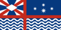
| name = Queen Adelaide Island | |||
| flag = QAI_Flag.png | |||
| capital = {{node|264518040|Lamington}} | |||
| population = 960,000 | |||
| confederation = 1825 | |||
| etymology = Named for Queen Adelaide of Ingrea (reigned ca. 1670–1710) | |||
| demonym = Queen Adelaide Islander, Islander, Adelaidean | |||
| postal = QA | |||
| motto = "Sic parvis magna" ("''Greatness from small beginnings''") | |||
| song = | |||
| largest-city = {{node|264518040|Lamington}} | |||
| other-metros = {{node|264518057|Port Albert}} | |||
| neighbors = {{Kastichetshan}}, Infernia, {{Peralia}}, Riverina, {{Wirramay}} | |||
| relation_id = 267000 | |||
| img-seal = | |||
| cap-seal = | |||
| img-bird = | |||
| cap-bird = | |||
| img-flower = | |||
| cap-flower = | |||
| img-tree = | |||
| cap-tree = | |||
| img-license = NEW ZEALAND, 2002 -AAA-000 SERIES, OLD TALL DIES, LICENSE PLATE - Flickr - woody1778a.jpg | |||
| cap-license = Standard license plate | |||
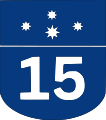
| img-shield = Australian Route 16.svg | |||
| cap-shield = Provincial highway shield | |||
| img-custom1 = Foxes of Island Beach State Park New Jersey (16138030480).jpg | |||
| cap-custom1 = Red fox<br>(provincial animal) | |||
| img-custom2 = Fisherman’s Wharf - April 2018 (6876).jpg | |||
| cap-custom2 = Town Basin, Lamington | |||
| img-custom3 = Aerial view of Vineyards in Barossa Valley.jpg | |||
| cap-custom3 = Midland County vineyards | |||
| img-custom4 = 20130721 Race the Cape 2013 - Leg 3 Great Bras d'Or 0162.jpg | |||
| cap-custom4 = Queen Adelaide Island Bridge | |||
[...] | |||
| img-custom7 = | |||
| cap-custom7 = | |||
}} | |||
[[Category:Provinces of Deodeca| ]] | [[Category:Provinces of Deodeca| ]] | ||
[[Category:Index pages]] | [[Category:Index pages]] | ||
Latest revision as of 07:53, 23 July 2025
The provinces of the Deodeca are a constituent political entity within the country. This page provides a snapshot overview of some of the provinces.
| File:Symbol important note.svg Important technical notes to users |
|---|
| To include a state below, please use {{Snapshot Deodeca province}}. Note that there are required elements for the template to ensure a minimum amount of information (name, flag, capital, postal code, etc.). Information about required parameters may be found on the template page. Then, be sure to add the state to the table of contents manually. All states must appear in alphabetical order. |
| | ||
|---|---|---|
| Capital: Kingstown | Population: 9,497,000 | |
| Confederation: 1872 Etymology: Disputed between Agawaskway (native language) "wâskayikan" ("House") and "âkâýâsîmowin" ("Ingerish"). Demonym: Agawaskwayan, Aggie | Postal code: AA Official motto: "Prosper together." | Largest city: Kingstown Other population centers: Frontenac, Halkerston, Kuhlie |
| Neighboring provinces: | ||
| Gallery of province symbols | ||
-
 Flag of Agawaskway
 -
 The provincial flower, the Stiff-leaved goldenrod (Solidago rigida)
 -
 The provincial tree, Quaking aspen (Populus tremuloides)
 -
 Standard license plate (2014-present)
 -
 Motorway shield
 -
 The edge of Downtown, in Kingstown, AA.
 -
 Fields and greenhouses near Liana, AA.
 -
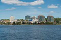 The skyline of Barton Bay, AA.


| | ||
|---|---|---|
| Capital: New Reydon | Population: 10,100,550 | |
| Confederation: 1710 Etymology: Ingerish (used to differentiate claims from Valonian Asperie) + Asperia (name used for the southwestern coast of Astrasia). Demonym: Asperian | Postal code: IA Official motto: "Illustratio, Moralis, Prudentia." ("Enlightenment, Morality, Prudence.") Provincial song: None | Largest city: Stonesipher Other population centers: Baptist Bay, Bathantown, Tidonmouth |
| Neighboring provinces: | ||
| Gallery of province symbols | ||
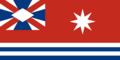
-
 Flag of Ingerish Asperia
 -
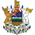 Coat of arms of Ingerish Asperia
 -
The provincial bird, the White-arched Stormpetrel (Hydrobates asperinus)
-
The provincial flower, the White mobgray (Vinca hepburnii)
-
The provincial tree, the Ironwood tree (Metrosideros excelsa)
-
 Highway shield
 -
Rugged coastline along the Shiralees.
-
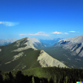
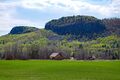
Foothills of the Great Shield Mountains near Coalcliffe, IA.


| | ||
|---|---|---|
| Capital: Coalburne | Population: 2,464,000 | |
| Etymology: Anglicised name derived from the Tsimshiliit word 'Kaasty’chyetshan.' Demonym: Kastichetshani | Postal code: KT Official motto: "Under the cross, we are well." Provincial song: Under The Cross, We Are Well | Largest city: Coalburne Other population centers: Delbert City, Port Stewart, Dimsdale, Cacsaw |
| Neighboring provinces: | ||
| Gallery of province symbols | ||
-
 Flag of Kastichetshan
 -
The provincial bird, the
Common Sapphire Dasher
(Malurus sapphirii) -
The provincial flower, The Purple Tikapa
(Tikapa tikapensis) -
The provincial tree, the West Jade Spruce (Picea nephritus)
-
 Auldanweller Valley in far west KT, with Mount Ernest on the far right.
 -
A farm near the foothills of the Great Shield Mountains near Jasper, KT
-
The Queen Charlotte Mountains near New Cottingham, KT


| | ||
|---|---|---|
| Capital: Roberton | Population: 3,680,000 | |
| Etymology: Named after Lake Ouanatchkan, itself a Valonian interpretation of Aitun 'Ukunatshuan', describing a bend in the rapids where Lake Ouanatchkan empties into the Odeka Demonym: Ouanatchkaner or Ouanatcher, Ouanatchkanien (FR), Chkanien (informal, FR) | Postal code: OA Official motto: "Sous le même toit, on est réuni" Provincial song: Chant Chkanien | Largest city: Audeville Other population centers: Anderville, Bennantown, Bésance, Fourchaulton |
| Neighboring provinces: Agawaskway, | ||
| Gallery of province symbols | ||
-
 Flag of Ouanatchkan
 -
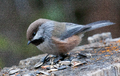 The provincial bird, the
Ardencian Chickadee
(Poecile ardencis) -
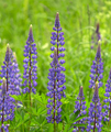 The provincial flower, the Southern Lupine
(Lupinus australis) -
The provincial tree, the Archantan Larch (Larix archantus)
-
 Provincial route shield
 -
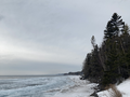 Coast of Lake Ouanatchkan in
Faille region -
 Rural landscape in Lévarrie Region
 -
Western terminus of the Northland Bridge
(Pont Northland)


| | ||
|---|---|---|
| Capital: Lamington | Population: 960,000 | |
| Confederation: 1825 Etymology: Named for Queen Adelaide of Ingrea (reigned ca. 1670–1710) Demonym: Queen Adelaide Islander, Islander, Adelaidean | Postal code: QA Official motto: "Sic parvis magna" ("Greatness from small beginnings") | Largest city: Lamington Other population centers: Port Albert |
| Neighboring provinces: | ||
| Gallery of province symbols | ||
-
 Flag of Queen Adelaide Island
 -
Standard license plate
-
Provincial highway shield
-
Red fox
(provincial animal) -
Town Basin, Lamington
-
Midland County vineyards
-
Queen Adelaide Island Bridge

.jpg)
.jpg)
.jpg)