Deodeca: Difference between revisions
| Line 181: | Line 181: | ||
==Government and Politics== | ==Government and Politics== | ||
<small>''Main article: [[Government of Deodeca]]''</small> | <small>''Main article: [[Government of Deodeca]]''</small> | ||
{{Infobox government | |||
| name = Deodeca | |||
| government_type = Federal constitutional parliamentary monarchy | |||
| capital = Stradworth | |||
| title1 = King | |||
| hos1 = Geoffrey IV | |||
| title2 = Prime Minister | |||
| hos2 = Hamish Lowell | |||
| legislature = Parliament | |||
| upper_house = Senate | |||
| upper_house_diagram = | |||
| lower_house = House of Representatives | |||
| lower_house_diagram = | |||
| judiciary = Supreme Court of Deodeca | |||
| custom_label1 = | |||
| custom1 | |||
| political_parties = {{legend|#FF9A27|PDK}}{{legend|#3F5FDF|PQ}}{{legend|#11436B|ALL}}{{legend|#840C55|PMM}}{{legend|#9B37C2|AT}}{{legend|#5FC03C|Bm}}{{legend|#DF3D3D|PF}} | |||
| international_orgs = AN | |||
}} | |||
=== Law === | === Law === | ||
Revision as of 07:58, 17 August 2023
 This encyclopedia article is about the country in Archanta. You may be looking for the collaboration page.
| Deodeca | |||||
|---|---|---|---|---|---|
| |||||
Loading map... | |||||
| Motto: "TBD" | |||||
| Capital | Stradworth | ||||
| Largest city | Kingstown | ||||
| Official languages | Ingerish | ||||
| • Regional languages | Franquese, Native Archantan Languages | ||||
| Demonym | Deodecan | ||||
| Government | TBD | ||||
| • Monarch | Geoffrey VII | ||||
| • TBD | TBD | ||||
| • TBD | TBD | ||||
| Legislature | Parliament of Deodeca | ||||
| • Upper house | Senate | ||||
| • Lower house | House of Representatives | ||||
| Area | |||||
| • Total | 685,572 km2 264,701 sq mi | ||||
| Population | |||||
| • Census (2019) | TBD | ||||
| GDP (PPP) | |||||
| • Total | TBD | ||||
| Timezone | WUT+09:00 | ||||
| Currency | Deodecan dollar (DCD) | ||||
| Drives on the | right | ||||


Deodeca, officially the Commonwealth of Deodeca is a sovereign country in southern Archanta. It consists of 12 provinces that span 685,000 square kilometres (264,000 square miles), making it one of the largest countries in the world. It borders Ardencia and the FSA to the east and south-east, Ambrosia to the southwest, and AR043 to the west. The capital is Stradworth, and its largest city is Kingston. The Ambrosian exclave of Upper Crown (Haute Couronne)∈⊾ sits between the Deodecan provinces of AR060-3 and AR060-4. Deodeca is a member of the Ingerish Commonwealth, having gained independence from Ingerland in UNKNOWN YEAR. It is also a member of the Assembly of Nations.
Etymology
The name "Deodeca" was formed from an anglicisation of the word "Odeka". It was a name used by local tribes to refer to the huge river that orginated inland.
History
| History of Deodeca | |
|---|---|
| Ulethan colonisation | (1650-1750) |
| • Port Albert colony founded | 1678 |
| • Ingerish Asperia colony founded | 1700 |
| • King's Town founded | 1724 |
| The Troubles in Astrasia | 1757-1760 |
| • FSA cedes from the Ingerish Empire | 1757 |
| • The "Inland Effort" | 1759 |
| • Treaty of Arguiel | 1760 |
| • Gleburn Territory acquired from Franqueterre | 1770 |
| Federalisation | 1790-1890 |
| • Capital District formed | 1790 |
| • Clamash purchase | 1800 |
| • Federation of the colonies | 1820 |
| • Dominion of Deodeca formed | 1830 |
Pre-Ulethan History
The earliest inhabitants of the Deodecan territory were various Native Archantan (or Native Astrasian) groups that prehistorically migrated from North Archanta. These tribes became culturally and physically distinct from other native tribal groups such as ones located in the Federal States and Ardencia. Among the hundreds of tribes, each developed their own unique internal culture and mythologies. Within Deodeca, there were over TBD major groups that formed rudimentary 'tribal empires'. The Tshayhamhash people of Ingerish Asperia once occupied a large empire that covered the northern portion of Ingerish Asperia. With history being passed down through oral history and art, much of today's knowledge is developed from archaeological findings.

Native groups have been retrospectively grouped by geographic area to a total of six groupings. The North Horn First Nations (Ingerish Asperia and Katichtishan), Central Prairie First Nations (Central Deodeca), Northeast First Nations (Peralia and part of -11), Island First Nations (Queen Adelaide Island), Lake First Nations (Nawagan and Agawaskway) and Alpine First Nations (Ateria and Ouanatchkan). These groupings refer to individual tribes that shared somewhat common cultural traits with each other.
Native peoples largely lived off the land and commonly hunted bison, deer, rodents, and occasionally birds. Fishing was also very common and Ulethan explorers described very advanced fishing techniques and technologies developed by some tribes. Tribes usually lived along rivers or near water areas. Canoes and boats were constructed using bison or deer hide and were used for transportation and fishing.
There were sometimes conflicts between groups and native oral history describes a particular long and bloody war between TBD and TBD some TBD years ago. Interactions with groups outside of the Deodecan region were rare, mainly due to natural barriers. Some trading was done by lake tribes, as boats allowed for easy access across the lake. The Queen Adelaide Island tribes remained largely isolated from the greater landmass for hundreds of years and developed a distinctly unique cultural and spirituality.
For thousands of years, the indigenous groups occupied the land without any interaction with Ulethan peoples.
Deodecan Colonies
Early exploration and colonisation

Following a global wave of colonisation by Ulethan powers, Queen Adelaide of Ingerland heard of bountiful lands to the southeast, across the Asperic Ocean. A year earlier, Franquese explorers had reached a previously unknown land, subsequently named Asperia, and set up a rudimentary settlement in present-day Meridien, Ambrosia. Desiring to beat the Franques to the best land, an extensive colonisation and exploratory fleet set sail from Ingerland on TBD. This fleet consisted of 13 ships and was commanded by TBD. The Ingerish planned to head further north than where the Franques landed. This led them to the Sea of Deodeca, where they made landfall at Port Albert, QAI.
The explorers discovered a sheltered harbour and fruitful land. In their report to the Queen, they described a perfect environment for further colonisation. Two years later, an even larger fleet set out, this time intending to develop a more developed and well-supplied post at Hepburn Bay. On arrival, the city of Lamington was proclaimed and is considered the first officiated city in Deodeca. Early life in Lamington was pleasant as the surrounding waters and land allowed for plentiful food and resources.

Contact with the Upper Nantee tribe just north of Lamington was the first recorded interaction the Ingerish had with the native peoples of Deodeca. The exchange mainly involved the groups watching each other from a distance, seemingly shocked at either's presence. Among the colonists at Lamington was Dr. Thomas Goodhope, a linguist who specialized in non-Ulethan languages. He had previously been part of expeditions exploring Tarephia and some parts of Antarephia. This gave him a well-informed mindset involving indigenous peoples. This became extremely useful during future encounters, where Lamington developed good relations with neighbouring tribes.
Lamington reached a population of 500 residents in TBD. Upon this, the Queen granted the colony governance and in TBD, the colony of Lamington was declared. In TBD, a new settlement was established at Ingerfort. This was the first settlement formed on the continental mainland. Explorers had surveyed the coastline from Westcott all the way to Lamington. Once Queen Adelaide Island was circumnavigated and further towns developed between Lamington and Port Albert, the colony was renamed to Queen Adelaide Island.
In TBD, the Ingerish made landfall at an indigenous settlement known as Ironwood Bay. This settlement happened to be the capital of the indigenous Speshxen Kingdom, a nation that covered the north of the Horn of Deodeca. The natives greeted the foreigners with open arms, and the Ingerish quickly discovered that the Speshxen had an advanced, complex society, a pension for business, and a concept of currency, unlike the majority of tribes in the area. The Ingerish, realising that subjugation of the native kingdom would be unfeasible, instead agreed to recognise the independence of the Speshxen Kingdom.
In TBD, settlements had been established at New Reydon, Coalburne, and Creswick. This wave of expansion had been fuelled by the extensive migration of Ulethans, driven by the prospects of abundant resources and opportunities in the area. In TBD, The colony of Kastichetshan, Peralia, Clamash, and Ingerish Asperia were proclaimed. The naming of Ingerish Asperia related to a feud between the Ingerish and Franquese powers, both looking to claim most of the Asperia region.
In TBD, following the ignition of the feud between Ingerland and Franqueterre, the Ingerish once again returned to the Speshxen Kingdom and declared protectorate status over the nation, preserving the Ingerish claim to the Northern Horn. After this declaration, the Speshxen Kingdom officially became known as the Tshayhamhash Protectorate. In the coming decades, the Speshxen pension for business came to a head, with the kingdom agreeing to monetary deals that ceded most of their land to the Ingerish and the Colony of Ingerish Asperia, until it was decreed by Speshxen law that further land sales were to be prohibited.
In TBD, explorers undertook a huge overland journey, aiming to survey the interior of the land east of the Great Shield Mountains. This led them to discover Lake Amanceer and Lake Beautouis. Recognising the strategic importance of the location, a settlement named Kingstown (after the then-King TBD), was founded and formed the colony of Agawaskway.
At this point, the largest city was Lamington and served as the unofficial capital and hub of the colonies in the region. Although the colonies were all independent of each other, desires to unite were strong early on.
War of Clamash
Castalleanese colonization to the north and proximity to the Deodecan colonies prompted the Ingerish to claim the southernmost of Castallean's claims. This included the port of San Ramon in present day Clamash. The Ingerish blockaded the port, aiming to tire out the settlers without any violence. A Castellanese frigate arrived and a standoff ensued. Luckily, no engagement occured and the Ingerish fleet allowed the frigate to pass and transfer the settlers to another Castellanese settlement. This in turn was deemed an Ingerish victory and Clamash was declared a new colony, following the founding of the city of Wahanta along the Henrietta River estuary. As per the Treaty of San Ramon, Castellan ceded all territory claims in present-day Clamash with the exception of San Ramon.
Unionification
Clamash Purchase
Soon after the colonization of Deodeca, Ingerish exploration led them around the Astrasian continent and to the eastern coast. Due to the distance, this area was from most Ulethan powers, it remained largely unexplored and unnoticed. This allowed for the Ingerish to stake their claim without any interference from rival powers.
- INSERT BRIEF FSA HISTORY*
In TBD, The colonies of Deodeca united and the Deodecan Federation was proclaimed with the exception of the Tshayhamhash Protectorate, then a separate legal entity under Ingerish sovereignty.
Due to the rapid industrialization and economic growth of the FSA, pressures within the Province of Clamash grew. Separatist movements grew extremely popular in the 1830s, mainly due to the perceived benefit to the Clamashigan economy by joining the States. In 1842, recognising the value of the province to the Federal States, the FS Congress made an offer of $TBD to purchase the province and allow it to be admitted in the States. The Deodecan parliament accepted the offer and Clamash officially ceded and joined the FSA as a territory. In 1866, The Clamash territory officially became the latest state. After this, the Deodecan constitution was amended to make further secession from the federation extremely difficult.
Modern History
In TBD, prior to the Great War in attempts to avoid being used as an unwilling base for opposing powers, the Tshayhamhash Protectorate petitioned the Deodecan government to admit the protectorate as a separate, new province. After months of strained talks and compromises, the protectorate was admitted as an autonomous region of Deodeca, known as the Tshayhamhash Governorate.
Geography
Deodeca has vast and varied geography that covers a large portion of western Astrasia. Deodeca has extensive maritime borders that extend into the "Sea of Deodeca" and some of the Grand Lakes (Lake Amanecer and Lake Betaouais), giving it a large EEZ.
Climate
Northern Deodeca sits mainly within the Cfa and Cfb climate ranges in the north. These provinces are most susceptible to thunderstorms and strong ocean winds. Ingerish Asperia's western coast is most prone to these seaborne storms and breezes due to its position on the Asperic northward current, and is the wettest part of the country. Areas east of (insert name of mountain range), such as eastern Ingerish Asperia and Kastichetshan, receive lower precipitation due to the rain shadow.
As for Southern Deodeca, its distance from the ocean guarantees a mostly continental climate (primarily Dfa and Dfb). However, the number of large lakes allows for a more humid climate in these regions, further enabling the lush temperate to boreal forests that dominate the southern half of the country. Lake-effect snowfall is especially high on eastern shores of Lake Ouanatchkan, as well as in limited amounts along lakes Betaouais and Amanecer.
Hydrology
Deodeca's abundance of water resources is due to its density of water networks. Deodeca has over 200 major rivers. Major rivers include Ingerish Asperia's River Agnes and Umbra River, Peralia's Jersey River, Agawaskway's Frontenac River, Ouanatchkan's Edrange River, and above all, the Odeka River, which flows through the central part of the country. The river is fed by several smaller tributaries and provides water for agriculture, industry, and domestic use. The Odeka River is also an important transportation route, with boats and barges transporting goods and people along its length.
The lakes of Deodeca are an important resource, both economically and environmentally. The largest lake within the country is Lake Ouanatchkan, which is located in the southern part of the country. The lake is fed by several rivers and is an important breeding ground for several species of fish. Lake Betaouais, and Lake Amanecer are among the most important lakes in Deodeca. These contribute to inland Deodeca's moderated climate and provide water resources for humans and the environment.
The wetlands of Deodeca are also vital ecosystems, providing habitat for a variety of plant and animal species. The country's wetlands are home to several species of birds, including herons, egrets, and snipes. The wetlands are also important breeding grounds for several species of fish, and they provide natural water filtration services.
Biodiversity

Liedbeck's mountain goat

Red deer
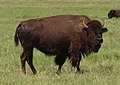
Deodecan bison

Alpine chamois

Southern eagle

Perch
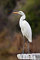
Little egret

Bell snipe


.jpg)


The country's varied terrain and climate have contributed to a diverse range of flora and fauna, making it an ideal destination for nature enthusiasts and scientists alike.
The forests of Deodeca are particularly noteworthy, with a mix of deciduous and coniferous trees providing habitat for a wide variety of wildlife. These forests are home to several species of deer, including the red deer and roe deer, as well as predators such as the Astrasian lynx and a small population of grey wolf. In addition, the forests are also home to several species of woodpeckers, owls, and other bird species. Within the prairie and meadows of Deodeca, the iconic Deodecan bison species thrive. The forested areas are also home to pockets of moose.
The alpine regions of Deodeca are characterized by rocky terrain and sparse vegetation, but they are nevertheless home to a number of unique plant and animal species. Liedbeck's mountain goat, which is native to the region, is one of the most iconic animals of Deodeca's alpine regions. Other mammals found in these areas include the ibex and the Alpine chamois. The alpine region is also home to several bird species such as the Southern eagle, the Deodecan hawk, and the snow finch.

Deodeca's rivers and lakes are also important habitats for a variety of aquatic species. The rivers are home to several species of trout, while the lakes are home to various species of freshwater fish such as pike, perch, and carp. The country's wetlands are also important habitats for birds such as the great crested grebe, the little egret, and the Bell snipe.
Despite the rich biodiversity of Deodeca, the country faces several threats to its natural habitats and wildlife. Human activities such as logging, agriculture, and urbanization have contributed to deforestation and habitat loss. Pollution from industries and agriculture has also impacted the water quality of the country's rivers and lakes.
To address these threats, the government of Deodeca has implemented several conservation measures, including protected areas and wildlife reserves. Deodeca has historically been very progressive towards protected areas and most environmental areas are under some form of protection. The country has also signed international agreements to protect its biodiversity, including the Convention on Biological Diversity and the Kingstown Convention on Wetlands. These efforts have helped to protect and preserve Deodeca's unique ecosystems and wildlife for future generations to enjoy.
Government and Politics
Main article: Government of Deodeca
| Government of Deodeca | |
|---|---|
| Federal constitutional parliamentary monarchy | |
| Capital | Stradworth |
| Head of state | |
| • King | Geoffrey IV |
| • Prime Minister | Hamish Lowell |
| Legislature | Parliament |
| • Upper house | Senate |
| • Lower house | House of Representatives |
| Judiciary | Supreme Court of Deodeca |
Major political parties | |
PDK PQ ALL PMM AT Bm PF | |
| AN | |
Law
Foreign relations and military
The Military of Deodeca encompasses the armed forces of the sovereign nation of Deodeca. As a modern and well-equipped military organization, it is composed of four major branches: the Deodecan Army, Deodecan Navy, Deodecan Air Force, and Deodecan Lake Guard.
The Deodecan Army serves as the land warfare branch of the military. It is responsible for protecting Deodeca's borders, conducting land-based operations, and providing support during national emergencies. The Deodecan Army boasts a highly trained and professional force, consisting of infantry units, armored and mechanized divisions, artillery regiments, and specialized combat support and logistics units.
.jpg)

The Deodecan Navy is responsible for safeguarding Deodeca's territorial waters and ensuring maritime security. With a focus on defense and power projection, it maintains a fleet of modern warships, including frigates, corvettes, submarines, and patrol vessels. The navy also operates two aircraft carriers and multiple amphibious assault ships to support expeditionary operations. Additionally, the Deodecan Navy maintains a dedicated naval aviation branch with fixed-wing aircraft and helicopters.
The Deodecan Air Force is responsible for air superiority, aerospace defense, and air support operations. It operates a diverse fleet of fighter jets, transport aircraft, helicopters, and unmanned aerial vehicles. It also maintains airbases, radar systems, and missile defense systems to safeguard Deodeca's airspace. The Deodecan Air Force excels in aerial combat, surveillance, and reconnaissance missions.
The Deodecan Lake Guard is responsible for safeguarding Deodeca's Grand Lakes territorial waters. Although practically the same as the navy, it has a long history and tradition that has allowed it to remain a separate force that operates under its own command. It has more of a focus on maritime security and civilian support rather than warfare.
The Deodecan Special Forces, known as the Special Tactics and Rapid Response Group (STARR), are an elite and highly skilled group within the military. They excel in unconventional warfare, counterterrorism, and specialized operations. Comprised of highly trained and selected personnel, they undergo rigorous training and possess expertise in various fields such as airborne operations, amphibious warfare, and counterinsurgency. The STARR group plays a crucial role in both national defense and on occasion, international peacekeeping missions. They achieved national recognition in 1990 during an attempted territorist attack in Kingstown's downtown. The STARR group was deployed and achieved overwhelming success: neutralizing all terrorists and only losing one civilian out of 34 hostages.
The military of Deodeca operates under a unified command structure, with the Chief of the Defense Force serving as the highest-ranking military officer. The armed forces prioritize professionalism, discipline, and adherence to international laws and conventions. They play a vital role in protecting the sovereignty and security of Deodeca, while also actively participating in humanitarian assistance and disaster relief operations through AN peacekeeping.
Subdivisions
Deodeca is a federation of 14 provinces.

| Flag | Name | Coat of arms | Code | Capital City | Largest City | Population | Total Area in km² (mi²) | Land Area in km² (mi²) | Map |
|---|---|---|---|---|---|---|---|---|---|
| Agawaskway | AW | Kingstown | Kingstown | 8,500,000 | 46,134.08 (17,812.47) | 37,726.49 (14,566.28) | Map∈⊾ | ||
| Argueil | 
|
AG | Liernase | Liernase | 8,220,000 | 41,977.52 (16207.61) | TBD (TBD) | Map∈⊾ | |
| Ateria | AT | Glenburn | Glenburn | 5,926,000 | 56,002.26 (21,622.59) | 52,108.68 (21663.68) | Map∈⊾ | ||
| Ingerish Asperia | 
|
IA | New Reydon | Stonesipher | 10,100,550 | 126,605.94 (48,882.83) | 99,884.22 (38,565.51) | Map∈⊾ | |
| Kastichetshan | KT | Coalburne | Coalburne | 2,464,000 | 69,145.07 (26,697.06) | 52,635.98 (20,322.87) | Map∈⊾ | ||
| Nawagan | NW | Wadeville | Fayette | 5,300,000 | Ex | Ex | Map∈⊾ | ||
| Odeka District | OD | Stradworth | Stradworth | TBD | Map∈⊾ | ||||
| Ouanatchkan | OA | TBD | Audeville | 3-4 million | Map∈⊾ | ||||
| Peralia | 
|
PE | Creswick | Creswick | 7,228,361 | 49,330.44 (19,046.59) | 43,287.75 (16,713.49) | Map∈⊾ | |
| Queen Adelaide Island | QAI | Lamington | Lamington | 956,849 | 32,510.17 (12,552.25) | 12,765.60 (4,928.83) | Map∈⊾ |
Economy
Industries
Aerospace
Karnell Commercial Airplanes was founded in Winding River in 1954 and is the largest aircraft producer in Deodeca. Their headquarters and test field are located in Winding River (1 Bralue Road, Dustin Arm, Ateria (J7C9Y5)). They produce all manner of commercial aircraft, the largest of which is the K830 and the smallest is the K110.
Automotive
Odeon was founded in Stradworth in 1910 and is one of the largest car manufacturers in the country. They are currently headquarted in Gattica. They produce mainly mid-range cars aimed at the general consumer. In 2008, Odeon launched their Odeon Gazette brand - more luxury and high-end car models.
Science and technology
Deodeca has a renowned technology industry, with some provinces focusing on premium consumer electronics, renewable solutions, and telecommunications. Out of Southern Deodeca have come many advanced tech companies including Argueil Telecom; a major provider of fibre optic, mobile telephony, and electronic communication. Within the nation this has fostered a large research and development industry with universities tailored to medical and scientific research being funded by philanthropists such as Hewett B. Whyte who used his fortune to build new labs in the early 2000s. Topping worldwide rankings such as the Global Research Consortium's annual publishing, Deodeca consistently ranks highly among other Archantan nations spending approximately 3.1% of GDP nominal on R&D alone.
Demographics
Health
Education
Ethnicity
Languages
Religion
Indigenous peoples
Transportation
Roadways

Deodeca developed a national highway network called the "Trans Deodecan Highway" (TDH) in 19XX to facilitate more efficient travel around the nation.
| Name | Length | Branches | Terminus A | Terminus B | Provinces | Map |
|---|---|---|---|---|---|---|
| TDH-1 | TBD | 1A | Betoaix, AG | Stonesipher/Baptist Bay, IA | AG, AW, -10, -03, KT, IA | Map∈⊾ |
| TDH-2 | TBD | None | Merburra, PE | Grand Cheval, AT | PE, -11, -10, -03, -04, AT | Map∈⊾ |
| TDH-3 | TBD | None | Great Shield Pass, KT | Archer, PE | KT, QAI, PE | Map∈⊾ |
| TDH-4 | TBD | 4A, 4B | Attingsford, PE | Les Prairies d'Edrange, OU | PE, NA, AW, OU | Map∈⊾ |
Railways
Maritime
The Odeka River serves as the backbone of shipping and transportation in Deodeca. The river is naturally navigable until Stradworth, while sections of rapids and shallow waters upstream presented challenges to larger ships until the construction of the Upper Odeka Canal Network (UOCN). This network of canals, locks, and dredging along the southern Odeka River opened Lake Ouanatchkan's ports to mid-size freighters, and heightened economic opportunity for the entirety of Southern Deodeca. Back downstream, the Ostally and the Frontenac Canals form the Odeka Lakes Canal Network (OLCN) that connects Lake Amanecer and Lake Betaouais to the Odeka and, by extension, to sea routes.


Culture
Symbols

The Deodecan eight-point star

Deodecan Bison

Odeka River

Deodecan Moose


Literature
Media
Visual arts
Tawnton Studios in Port Landley, AW, is one of the most famous film studios in Deodeca and was responsible for many of the early films produced in the country. The adjoining Silentland complex is the location of some of the first films made in Deodeca and Archanta. Nowadays, the studios are still used for major film production, however Silentland has been converted into a tourist attraction.
Music
Sports
Eric Hyledeman (1939-2019) born in Hauts-de-la-Patrie, OA, was a gold-medalist skiier. He won gold for skiing during the 1960 Pax Nova Games. He was honoured with a park in his name and later, after his death, a highway leading to La Patrie was renamed.
See Also
Notes
| Provinces | |
|---|---|
| Capital District | Odeka District |