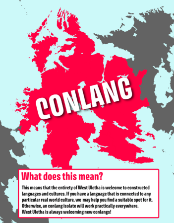
OpenGeofiction:West Uletha

West Uletha is the western half of the largest continent on OGF - Uletha. The eastern half is East Uletha. With great size comes great diversity in geography, culture, climate, geology, history, etc. West Uletha is imagined as the home of most European cultures including English, French, German, Italian, Polish, Portuguese, Russian, Spanish and many more. Along with those, it features certain non-European cultures including those from the Middle East, Southern Asia, Central America and the rest of the world. Finally, it is also home to many fictional languages and cultures that users have created.
The subcontinent is home to a vast number of biomes and landscapes. Dominated by the temperate zones, it also features large swats of the mediterranean biome, as well as a sizeable amount of taigas, tundras, steppes and tropical rainforests. The rest of the subcontinent is composed of hot deserts, polar deserts, glacial terrain, alpine tundra, and all other kinds of biomes.
West Uletha is incredibly large, being home to the northernmost point of land in the world, while also having land south of the Equator. As of the 21st of March, 2024, it features 146 independent countries.
It is worth mentioning that West Uletha is NOT supposed to be a 1:1 copy of Europe and was and will never be imagined as such, however there are certain similarities between the two areas. The subcontinent is coordinated and managed by administrators Bixelkoven and Alessa.
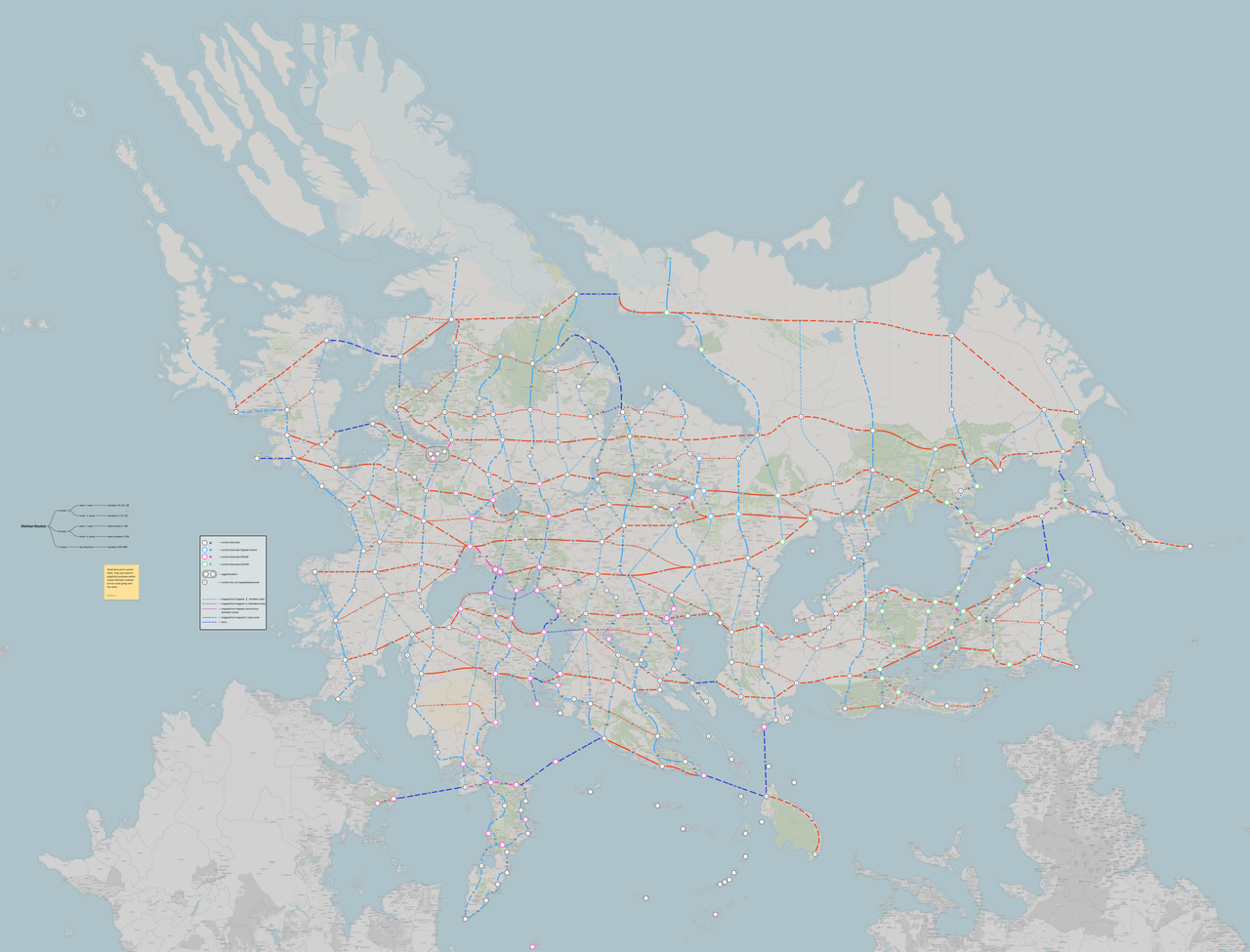
Overview map
Loading map...
Maps of West Uletha
- West Uletha (as of 03 May 2024)
-
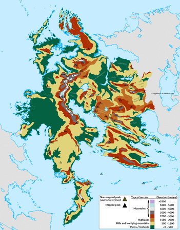 Rough elevation and terrain map
 -
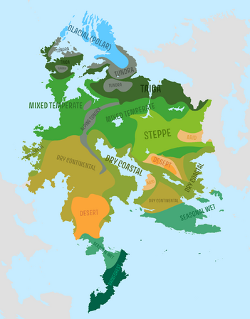 Biomes map
 -
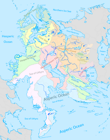 Major rivers and drainage basins map
 -
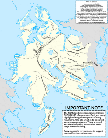 Mountain ranges map
 -
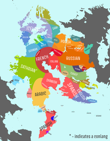 Map of currently predominant languages in each area
 -


Regions
- Regions of West Uletha (as of 03 May 2024)
-
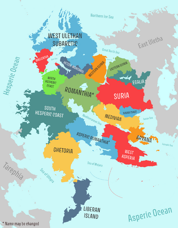

West Uletha is divided into 17 regions that group together various territories with similar cultures, histories and themes. Each region is numbered and they area reflected in the territory codes. For example, a territory with the code UL01a is located in the region 01 - South Hesperic Coast. The infographics below should introduce users to each region in more detail.
- Regions of West Uletha
-
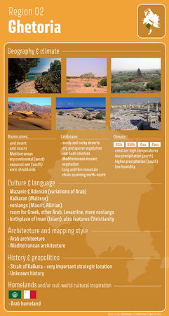 Ghetoria
 -
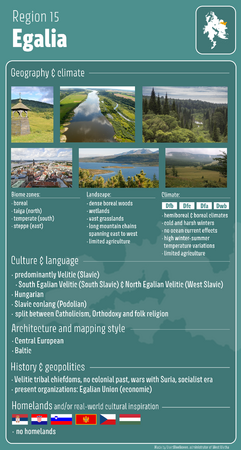 Egalia


Homeland countries
West Uletha is home to most of the countries known as 'homelands'. These are nations that serve as the cultural and historical origins of other countries in the OGF world, primarily through colonization. Many countries in Archanta, Antarephia, and Tarephia are envisioned as former colonies, and West Uletha is where most of their founding nations are based. These homeland countries are large, influential, and were once colonial empires. Most of them are collaborative projects and are observed by the continental administrators.
No user is allowed to own a territory which would act as a homeland of the cultures mentioned below, but it is allowed to own a country which has a similar culture to one of them. Those countries are:
| Country | Inspiration from the real world | Collab page |
|---|---|---|
| Collab page / Forum page | ||
| Collab page | ||
| Collab page / Forum page | ||
| Territory is not a collab | ||
| Collab page | ||
| Naphon | Collab page | |
| Collab page | ||
| Collab page / Forum page | ||
| Collab page / Forum page | ||
| Veliticia | Collab page / Forum page |
Some countries that act as homelands, but aren't officially considered as such nor are they designated as such by the admin team, include:
- Balam-Utz - Mayan culture and language
- Beldonia - Slovenian culture and language
- Demirhan Empire - Turkish culture and language
- Drabantia - Czech culture and language
- Dregolesia within Geklinia-Dregolesia - Ukrainian culture and language
- Garlis - Romanian culture and language
- Kalkara - Maltese culture and language
- Larcetany - Catalan culture and language
- Malesoria - Albanian culture and language
- Mallyore - Croatian culture and language
- Navenna - Venetian culture and language
- Saave - Estonian culture and language
- Silland - Various Sami cultures and languages
- Zalivnia - Serbian culture and language
Community collaboration and consensuses
The community of OpenGeofiction will be invited to partake in various discussions in regards to the continental consensus of West Uletha. This includes, but is not limited to: names of geographic features, continental geography, notable historic events, cross-continental naming conventions (like road numberings), and others. This comes with the goal to standardize certain aspects of the West Ulethan environment and community, as well as to increase the level of collaboration in the continent. Different discussions will be opened in the forums and linked here with the verdicts. Users are welcome to open their own topics on the forum.
Topic 1: Toponyms
Within this topic we will cover the most notable geographic features in West Uletha and give them a name if they don't already have one, or change existing outdated ones! Everyone is welcome to suggest names for each feature. Larger features' names will be chosen by everyone, whilst smaller but notable features' names will be chosen by the active users in the respective region. Certain established names will not be changed.
The full discussion is located at TBC.
Topic 2: Continental Route Numbering
A collaborative effort to create a continental scheme for numbering roads in Uletha (East and West) - the U-roads. All details regarding the proposal, as well as the discussion around the topic, can be found at the forum post of the relevant topic: Link
Idea: More than 40 routes patterns have been defined across Uletha following a grid, labeling routes based on the west-east and north-south axes. The routes run across Uletha connecting control cities (at least one per territory). The exact route on the map is to be defined by the mappers involved between the control cities, whereas this numbering scheme is merely a guide. Mappers are also welcome to define routes which can connect areas and settlements not covered by the scheme.
Alternatively, use this link, if the previous one doesn't work for whatever reason.
Rules and guidelines:
- Lore-wise, the scheme was created by ASUN in West Uletha, and the plan spans the entirety of Uletha, East and West. Whether East Uletha (EUOIA) recognizes this effort, or not, the scheme is in place. This is mimicking the E-road system which encompasses the entirety of Europe and parts of Asia, regardless of the socio-political climate in the area.
- The scheme/proposal is non-binding, meaning no country is required to adopt it.
- The scheme defines A-class and B-class routes, whereas all users are welcome to 'fill in the gaps' by defining C-routes with their neighbors.
- The numbering scheme is Uxx, where xx is a specific route, such as U5, U25, or U251. No hyphens or other symbols are present.
|
How to map:
|