|
|
| (7 intermediate revisions by the same user not shown) |
| Line 1: |
Line 1: |
| {| | | {| |
| |- | | |- |
| | style="background:#ffd9e2; border:1px solid #ff2659; padding:1em; margin:auto;"| [[File:BA road sign I-25.svg|30px]] '''<span style="color:#fa0032">NOTE:</span>''' This page is currently under construction. Some info is prone to changes and mistakes may be present! [[File:80X80-yellow-red-animation.gif|30px]] | | | style="background:#ffd9e2; border:1px solid #ff2659; padding:1em; margin:auto;"| [[File:BA road sign I-25.svg|30px]] '''<span style="color:#fa0032">NOTE:</span>''' This page is currently under construction. Some info is prone to changes and mistakes may be present! |
| |- | | |- |
| |} | | |} |
|
| |
|
| <table style="width:100%;table-layout:fixed;vertical-align:top;"><tr>
| | [[File:WU warning.png|right|300px]] |
| <!-- Start of left-column --> | | <!-- Start of left-column --> |
| <td style="vertical-align:top;">
| | '''West Uletha''' is the western half of the largest continent on OGF - Uletha. The eastern half is [[OGF:East Uletha|East Uletha]]. With great size comes great diversity in geography, culture, climate, geology, history, etc. West Uletha is imagined as the home of most European cultures including English, French, German, Italian, Polish, Portuguese, Russian, Spanish and many more. Along with those, it features certain non-European cultures including those from the Middle East, Southern Asia, Central America and the rest of the world. Finally, it is also home to many fictional languages and cultures that users have created. |
| '''West Uletha''' is the western half of the largest continent on OGF - Uletha. The eastern half is [[OGF:East Uletha|East Uletha]]. With great size comes great diversity in geography, culture, climate, geology, history, etc. West Uletha is imagined as the home of most European cultures including English, French, German, Italian, Polish, Portuguese, Russian, Spanish and many more. Along with those, it features certain non-European cultures including those from the Middle East, Southern Asia, Central America and the rest of the world. It is worth mentioning that West Uletha is NOT supposed to be a 1:1 copy of Europe and was and will never be imagined as such, however there are certain similarities between the two areas. | |
|
| |
|
| The subcontinent is coordinated and managed by administrators '''[[User:Bixelkoven|Bixelkoven]]''' and '''[[User:Alessa|Alessa]]'''. | | The subcontinent is home to a vast number of biomes and landscapes. Dominated by the temperate zones, it also features large swats of the ''mediterranean'' biome, as well as a sizeable amount of taigas, tundras, steppes and tropical rainforests. The rest of the subcontinent is composed of hot deserts, polar deserts, glacial terrain, ''alpine'' tundra, and all other kinds of biomes. |
|
| |
|
| {| role="presentation" class="wikitable mw-collapsible mw-collapsed"
| | West Uletha is incredibly large, being home to the northernmost point of land in the world, while also having land south of the Equator. As of the 21st of March, 2024, it features 146 independent countries. |
| | <strong>Basic info regarding West Uletha</strong>
| |
| |-
| |
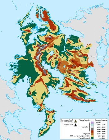
| | Geographically, West Uletha is incredibly diverse and complex. Although consensus regarding tectonic plates and fault lines has not been reached, there's clear indicators that West Uletha is packed with them. As a result, the subcontinent features numerous mountain ranges, island chains, peninsulas and even rift zones. Likewise, due to its massive land area, West Uletha boasts a wide variety of climate zones from the hottest to the coldest, and from the wettest to the driest. From the coldest fjords and tundras in the far north, deserts in the southwest, steppes and grasslands in Suria and the Egalian region, tropical islands in the Asperic Ocean, rainforests on the Liberan Island and everything in between.
| |
| | |
| Culturally and linguistically, West Uletha roughly follows the cultural lines of Europe, however it is not identical to it. Alongside the 3 main linguistic and cultural groups (Romance, Slavic and Germanic) which dominate the cultural landscape of West Uletha, you can find the Baltic and Finno-Ugric people groups in the northern lands, Indo-Aryan, Iranian and Turkic groups in the south, Semitic and Hellenic in the southwest, as well as Celtic in the northwest. In between all these people groups is a wide network of community-created conlangs and variations.
| |
|
| |
|
| Finally, West Uletha has no defined socio-political and economical image, and that remains ever-changing with each new territory, however it is generally imagined that West Uletha is one of the wealthier subcontinents. The subcontinent is filled with various types of countries and governments, former colonial powerhouses, tax havens, empires, microstates, duchies, kingdoms, socialist republics, dictatorships, etc. This all adds up to the already rich tapestry of the unique territories in West Uletha.
| | It is worth mentioning that West Uletha is NOT supposed to be a 1:1 copy of Europe and was and will never be imagined as such, however there are certain similarities between the two areas. The subcontinent is coordinated and managed by administrators '''[[User:Bixelkoven|Bixelkoven]]''' and '''[[User:Alessa|Alessa]]'''. |
|
| |
|
| Fun facts:
| |
| *West Uletha spans between 79.5° N at {{way|150475722|Point Eldfjallafylki}} and -8° S at {{way|22087614|Ytakolo'my Island}} latitude wise. Longitude wise, it spans between 18° W at an {{way|83226|unnamed island}} and 101° E at [https://opengeofiction.net/search?whereami=1&query=52.05988%2C101.04022#map=10/52.0599/101.0402&layers=B an unnamed point].
| |
| *West Uletha has 174 territories.
| |
| |}
| |
|
| |
|
| <td style="vertical-align:top;width:500px;">
| | == Overview map == |
| {{#multimaps: | | {{#multimaps: |
| | service = OGF | | | service = OGF |
| | center = 55,40 | | | center = 45,60 |
| | height = 500px | | | height = 500px |
| | zoom = 2 | | | zoom = 3 |
| | maxzoom = 9 | | | maxzoom = 9 |
| | layers = +Standard | | | layers = +Standard |
| Line 45: |
Line 35: |
| ] } | | ] } |
| }} | | }} |
| </td>
| |
| </tr></table>
| |
| [[File:WU warning.png|left|200px]]
| |
|
| |
|
| == Geography and climate == | | == Maps of West Uletha == |
| <gallery mode=packed caption="Geography of West Uletha" widths="300px" heights="300px"> | | <gallery mode=packed caption="West Uletha (as of 03 May 2024)" widths="300px" heights="300px"> |
| File:Wu_ele.png|Rough elevation and terrain map | | File:Wu_ele.png|Rough elevation and terrain map |
| File:WuBiomes.png|Biomes map | | File:WuBiomes.png|Biomes map |
| File:Wu waters.png|Major rivers and drainage basins map | | File:Wu waters.png|Major rivers and drainage basins map |
| File:Wu mt ranges.png|Mountain ranges map | | File:Wu mt ranges.png|Mountain ranges map |
| </gallery>
| | File:WuLanguages.png|Map of currently predominant languages in each area |
| | |
| The geography of West Uletha is
| |
| | |
| == Cultures and languages ==
| |
| <gallery mode=packed caption="Cultures of West Uletha" widths="300px" heights="300px">
| |
| File:WuLanguages.png | |
| File:Wu conlang.png | | File:Wu conlang.png |
| </gallery> | | </gallery> |
|
| |
|
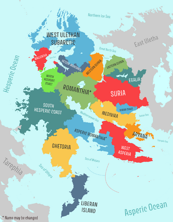
| == Regions == | | == Regions == |
| <gallery mode=packed caption="Regions of West Uletha" widths="300px" heights="300px"> | | <gallery mode=packed caption="Regions of West Uletha (as of 03 May 2024)" widths="300px" heights="300px"> |
| File:WuRegions.png | | File:WuRegions.png |
| </gallery> | | </gallery> |
| West Uletha is split into 17 sectors, numbered from 1-17, which designate areas with cultural similarities. These can be identified in the first two digits of West Ulethan territory codes (for example: UL17x is a territory in sector 17, the ''Iviran Coast'' region). | | West Uletha is divided into 17 regions that group together various territories with similar cultures, histories and themes. Each region is numbered and they area reflected in the territory codes. For example, a territory with the code UL01a is located in the region 01 - South Hesperic Coast. The infographics below should introduce users to each region in more detail. |
|
| |
|
| (Names in ''italic'' are proposed to be changed.)
| | <gallery mode=packed caption="Regions of West Uletha" widths="300px" heights="300px"> |
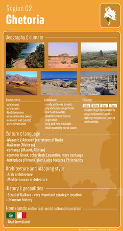
| | File:WU_02_Ghetoria.png|Ghetoria |
| | File:WU_15_Egalia.png|Egalia |
| | </gallery> |
|
| |
|
| === South Hesperic Coast (01) === | | == Homeland countries == |
| The South Hesperic Coast region is located in the southwestern part of the continent. It is composed of 4 territories, the largest of which is {{relation|255|Sathria}} covering over 80% of the region. It is home to {{relation|558|Roantra}}, the first territory on OpenGeofiction.
| | West Uletha is home to most of the countries known as 'homelands'. These are nations that serve as the cultural and historical origins of other countries in the OGF world, primarily through colonization. Many countries in [[Archanta]], [[Antarephia]], and [[Tarephia]] are envisioned as former colonies, and West Uletha is where most of their founding nations are based. These homeland countries are large, influential, and were once colonial empires. Most of them are collaborative projects and are observed by the continental administrators. |
|
| |
|
| {| style="width: 80%; margin: 0 0 0 10%; border-collapse: collapse; background: #FFFFFF; border: 1px solid #aaa; border-left: 10px solid #87a619;"
| | No user is allowed to own a territory which would act as a homeland of the cultures mentioned below, but it is allowed to own a country which has a similar culture to one of them. Those countries are: |
| |-
| |
| | style="width: 52px; padding: 2px 0px 2px 0.5em; text-align: center;" | [[File:Landscape.svg|40px]]
| |
| | style="padding: 0.25em 0.5em;" | '''Landscape''' <br/>The landscape is dominated by vast dry grassy plains and rugged rocky coasts. The region features a short coastline along the Mediterranean Sea, separated from the rest of the area by tall mountains.
| |
| |}
| |
| {| style="width: 80%; margin: 0 0 0 10%; border-collapse: collapse; background: #FBFBFB; border: 1px solid #aaa; border-left: 10px solid #f4c430;"
| |
| |-
| |
| | style="width: 52px; padding: 2px 0px 2px 0.5em; text-align: center;" | [[File:Draw raining.png|40px]]
| |
| | style="padding: 0.25em 0.5em;" | '''Climate'''<br/>The region is characterized by a drier climate, resembling that of the Maghreb region in Africa along the coast, and Anatolia in the continental areas. The southern part is particularly arid, while the northern parts near the North Hesperic Coast region are more temperate and less dry.
| |
| |}
| |
| {| style="width: 80%; margin: 0 0 0 10%; border-collapse: collapse; background: #FBFBFB; border: 1px solid #aaa; border-left: 10px solid #1e90ff;"
| |
| |-
| |
| | style="width: 52px; padding: 2px 0px 2px 0.5em; text-align: center;" | [[File:HSTheatre.svg|40px]]<br>[[File:HSA.png|40px]]
| |
| | style="padding: 0.25em 0.5em;" | '''Culture & language''' <br/> Dominated by the Sathrian culture (conlang). Also features Roantran (conlang) and Greek.
| |
| |}
| |
| {| style="width: 80%; margin: 0 0 0 10%; border-collapse: collapse; background: #FBFBFB; border: 1px solid #aaa; border-left: 10px solid #197ba6;"
| |
| |-
| |
| | style="width: 52px; padding: 2px 0px 2px 0.5em; text-align: center;" | [[File:HSHistory.svg|40px]]
| |
| | style="padding: 0.25em 0.5em;" | '''History''' <br/>
| |
| The history of this region is largely undefined.<br>The Mediterranean part was likely once part of the [[Forum:Global_and_regional_issues/History_of_Ancient_West_Uletha_and_North_Tarephia_-_Romantish_Empire|Romantish Empire]].<br>The Hellanesian colonies originated from {{relation|9304|Egani}}.
| |
| |}
| |
| {| style="width: 80%; margin: 0 0 0 10%; border-collapse: collapse; background: #FBFBFB; border: 1px solid #aaa; border-left: 10px solid #9ca8ad;"
| |
| |-
| |
| | style="width: 52px; padding: 2px 0px 2px 0.5em; text-align: center;" | [[File:Flag of Greece.svg|40px]]
| |
| | style="padding: 0.25em 0.5em;" | '''Homelands''' <br/> This region is the homeland of Hellanesian culture, which is based on Greek culture.
| |
| |}
| |
|
| |
|
| | | {|class='wikitable unsortable' |
| === Ghetoria (02) ===
| | ! Country |
| Located in the southwest of the continent, this region is characterized by dry, desert-like landscapes and a diverse cultural collage. It comprises ten territories, the largest of which is {{relation|135682|Mazan}}.
| | ! Inspiration from the real world |
| | | ! Collab page |
| {| style="width: 80%; margin: 0 0 0 10%; border-collapse: collapse; background: #FFFFFF; border: 1px solid #aaa; border-left: 10px solid #87a619;"
| | |- |
| |- | | | {{Castellan}} |
| | style="width: 52px; padding: 2px 0px 2px 0.5em; text-align: center;" | [[File:Landscape.svg|40px]] | | | [[File:Flag of Spain.svg|28px|border]] Spain |
| | style="padding: 0.25em 0.5em;" | '''Landscape''' <br/>Deserts predominate the interior landscape and extend to certain minor coastal areas. The remaining coastal regions are primarily of Mediterranean terrain, characterized by bushes and shrubs. Closer to the equator, the environment transitions to lush, dense forests with a more dynamic and rich wildlife.</small> | | | [[Collab:Castellán|Collab page]] / [[Forum:Official collaboratives/Castellán|Forum page]] |
| |} | | |- |
| {| style="width: 80%; margin: 0 0 0 10%; border-collapse: collapse; background: #FBFBFB; border: 1px solid #aaa; border-left: 10px solid #f4c430;"
| | | {{Florescenta}} |
| |- | | | [[File:Flag of Portugal.svg|28px|border]] Portugal |
| | style="width: 52px; padding: 2px 0px 2px 0.5em; text-align: center;" | [[File:Draw raining.png|40px]] | | | [[Collab:Florescenta|Collab page]] |
| | style="padding: 0.25em 0.5em;" | '''Climate'''<br/> The northern part of the region is one of the driest areas in West Uletha, with minimal rainfall. The entire region experiences warm temperatures, among the highest in West Uletha. In the south, a seasonal wet climate prevails, resulting in more frequent rainfall that enriches the vegetation.
| | |- |
| |} | | | {{Ingrea}} |
| {| style="width: 80%; margin: 0 0 0 10%; border-collapse: collapse; background: #FBFBFB; border: 1px solid #aaa; border-left: 10px solid #1e90ff;"
| | | [[File:Flag of England.svg|28px|border]] England |
| |- | | | [[Collab:Ingrea|Collab page]] / [[Forum:Ingrea|Forum page]] |
| | style="width: 52px; padding: 2px 0px 2px 0.5em; text-align: center;" | [[File:HSTheatre.svg|40px]]<br>[[File:HSA.png|40px]] | | |- |
| | style="padding: 0.25em 0.5em;" | '''Culture & language''' <br/> Dominated by the Arabic culture and language(conlang), together with Greek, Maltese and Maurit (conlang) areas. | | | {{Kalm}} |
| |} | | | [[File:Flag of Germany.svg|28px|border]] Germany |
| {| style="width: 80%; margin: 0 0 0 10%; border-collapse: collapse; background: #FBFBFB; border: 1px solid #aaa; border-left: 10px solid #197ba6;"
| | | ''Territory is not a collab'' |
| |- | | |- |
| | style="width: 52px; padding: 2px 0px 2px 0.5em; text-align: center;" | [[File:HSHistory.svg|40px]]
| | | {{Lentia}} |
| | style="padding: 0.25em 0.5em;" | '''History''' <br/> The history of this region is largely undefined.<br>The Strait of Kalkara and its surroundings were highly contested, with various states establishing settlements along its coast to exert control.<br>This region also features Hellanesian colonies and areas of influence. | | | [[File:Flag of Netherlands.svg|28px|border]] The Netherlands |
| |} | | | [[Collab:Lentia|Collab page]] |
| {| style="width: 80%; margin: 0 0 0 10%; border-collapse: collapse; background: #FBFBFB; border: 1px solid #aaa; border-left: 10px solid #9ca8ad;"
| | |- |
| |- | | | {{Mazan}} |
| | style="width: 52px; padding: 2px 0px 2px 0.5em; text-align: center;" | [[File:Flag of Malta.svg|border|40px]]<br>[[File:Flag of the Arab League.svg|border|40px]]<br>[[File:MauretiaFlag-new.svg|border|40px]] | | | [[File:Flag of the Arab League.svg|28px|border]] ''Arab culture'' |
| | style="padding: 0.25em 0.5em;" | '''Homelands''' <br/> This region is the homeland of the Kalkaran and Mazanic cultures, which are influenced by Maltese and Arabic cultures, respectively.<br>This region is the homeland of the Maurit culture. | | | |
| | |- |
| | | [[Naphon]] |
| | | [[File:Flag of Israel.svg|28px|border]] ''Jewish culture'' |
| | | [[Collab:Naphon|Collab page]] |
| | |- |
| | | {{Plevia}} |
| | | [[File:Flag of Italy.svg|28px|border]] Italy |
| | | [[Collab:Plevia|Collab page]] |
| | |- |
| | | {{Suria}} |
| | | [[File:Flag of Russia.svg|28px|border]] Russia |
| | | [[Collab:Suria|Collab page]] / [[Forum:Official collaboratives/Suria|Forum page]] |
| | |- |
| | | {{Valony}} |
| | | [[File:Flag of France.svg|28px|border]] France |
| | | [[Collab:Valonne|Collab page]] / [[Forum:Valonne|Forum page]] |
| | |- |
| | | [[Veliticia]] |
| | | [[File:Flag of Poland.svg|28px|border]] Poland |
| | | [[Forum:Official_collaboratives/Wełtycja|Collab page]] / [[Forum:Wełtycja|Forum page]] |
| | |- |
| |} | | |} |
|
| |
|
| === Liberan Island (03) ===
| | Some countries that act as homelands, but aren't officially considered as such nor are they designated as such by the admin team, include: |
| This region represents the southernmost territories in West Uletha, distinguished as the sole area extending south of the Equator. Comprising 13 territories, it bears a predominantly colonial heritage.
| | *[[Balam-Utz]] - Mayan culture and language |
| {| style="width: 80%; margin: 0 0 0 10%; border-collapse: collapse; background: #FFFFFF; border: 1px solid #aaa; border-left: 10px solid #87a619;"
| | *[[Beldonia]] - Slovenian culture and language |
| |-
| | *[[Demirhan Empire]] - Turkish culture and language |
| | style="width: 52px; padding: 2px 0px 2px 0.5em; text-align: center;" | [[File:Landscape.svg|40px]]
| | *[[Drabantia]] - Czech culture and language |
| | style="padding: 0.25em 0.5em;" | '''Landscape''' <br/>The landscape is characterized by dense jungle forests, offering a balanced combination of mountains and lowlands reminiscent of the Caribbean and certain regions of Mexico.
| | *Dregolesia within [[Geklinia-Dregolesia]] - Ukrainian culture and language |
| |}
| | *[[Garlis]] - Romanian culture and language |
| {| style="width: 80%; margin: 0 0 0 10%; border-collapse: collapse; background: #FBFBFB; border: 1px solid #aaa; border-left: 10px solid #f4c430;"
| | *[[Kalkara]] - Maltese culture and language |
| |-
| | *[[Larcetany]] - Catalan culture and language |
| | style="width: 52px; padding: 2px 0px 2px 0.5em; text-align: center;" | [[File:Draw raining.png|40px]]
| | *[[Malesoria]] - Albanian culture and language |
| | style="padding: 0.25em 0.5em;" | '''Climate'''<br/> The climate predominantly aligns with rainforest conditions, with portions in the north experiencing a seasonal wet climate as they distance themselves from the equator. Often subjected to monsoons, this region is reputedly one of the wettest in West Uletha, while maintaining consistently high temperatures.
| | *[[Mallyore]] - Croatian culture and language |
| |}
| | *[[Navenna]] - Venetian culture and language |
| {| style="width: 80%; margin: 0 0 0 10%; border-collapse: collapse; background: #FBFBFB; border: 1px solid #aaa; border-left: 10px solid #1e90ff;"
| | *[[Saave]] - Estonian culture and language |
| |-
| | *[[Silland]] - Various Sami cultures and languages |
| | style="width: 52px; padding: 2px 0px 2px 0.5em; text-align: center;" | [[File:HSTheatre.svg|40px]]<br>[[File:HSA.png|40px]]
| | *[[Zalivnia]] - Serbian culture and language |
| | style="padding: 0.25em 0.5em;" | '''Culture & language''' <br/> Culturally, Spanish influence holds sway, although vestiges of French, Italian, Nahuatl, and Mayan cultures can be found, owing to historical colonial ties. The indigenous peoples of this area remain unidentified, with much of the culture rooted in colonial heritage.
| |
| |}
| |
| {| style="width: 80%; margin: 0 0 0 10%; border-collapse: collapse; background: #FBFBFB; border: 1px solid #aaa; border-left: 10px solid #197ba6;"
| |
| |-
| |
| | style="width: 52px; padding: 2px 0px 2px 0.5em; text-align: center;" | [[File:HSHistory.svg|40px]]
| |
| | style="padding: 0.25em 0.5em;" | '''History''' <br/> The historical narrative of this region is largely shaped by its colonial past, with Franqueterre and Plevia establishing colonies alongside Castellanese dominance.
| |
| |}
| |
| {| style="width: 80%; margin: 0 0 0 10%; border-collapse: collapse; background: #FBFBFB; border: 1px solid #aaa; border-left: 10px solid #9ca8ad;"
| |
| |-
| |
| | style="width: 52px; padding: 2px 0px 2px 0.5em; text-align: center;" | [[File:Flag of the Mayan People.svg|border|40px]]
| |
| | style="padding: 0.25em 0.5em;" | '''Homelands''' <br/> This region possesses no homelands of any culture, however it does feature Mayan culture.
| |
| |}
| |
|
| |
|
| === Asperic ''Romanthia'' (04) === | | == Community collaboration and consensuses == |
| Situated as the southern extension of the expansive [[Forum:Global_and_regional_issues/History_of_Ancient_West_Uletha_and_North_Tarephia_-_Romantish_Empire|Romantish]] sphere of influence, this region borders the Asperic Ocean to its south, divided into western and eastern sectors by the [https://opengeofiction.net/#map=8/32.600/64.814&layers=B Strait of Vela]. Comprising seven territories, it stands as a nexus for some of the world's most influential cultures, notably including the Spanish homeland.
| | The community of OpenGeofiction will be invited to partake in various discussions in regards to the continental consensus of West Uletha. This includes, but is not limited to: names of geographic features, continental geography, notable historic events, cross-continental naming conventions (like road numberings), and others. This comes with the goal to standardize certain aspects of the West Ulethan environment and community, as well as to increase the level of collaboration in the continent. Different discussions will be opened in the forums and linked here with the verdicts. Users are welcome to open their own topics on the forum. |
|
| |
|
| {| style="width: 80%; margin: 0 0 0 10%; border-collapse: collapse; background: #FFFFFF; border: 1px solid #aaa; border-left: 10px solid #87a619;"
| | === Topic 1: Toponyms === |
| |-
| | Within this topic we will cover the most notable geographic features in West Uletha and give them a name if they don't already have one, or change existing outdated ones! Everyone is welcome to suggest names for each feature. Larger features' names will be chosen by everyone, whilst smaller but notable features' names will be chosen by the active users in the respective region. Certain established names will not be changed. |
| | style="width: 52px; padding: 2px 0px 2px 0.5em; text-align: center;" | [[File:Landscape.svg|40px]]
| |
| | style="padding: 0.25em 0.5em;" | '''Landscape''' <br/>The landscape presents a predominantly Mediterranean and arid character, characterized by shrublands, sparse forests, and intermittent rivers. In the western sector, terrain varies between lowlands, predominantly flat highlands, and rugged mountains forming part of the expansive Great Ulethan mountain chain. Conversely, the eastern reaches are predominantly mountainous, marked by multiple ranges traversing the area.
| |
| |}
| |
| {| style="width: 80%; margin: 0 0 0 10%; border-collapse: collapse; background: #FBFBFB; border: 1px solid #aaa; border-left: 10px solid #f4c430;"
| |
| |-
| |
| | style="width: 52px; padding: 2px 0px 2px 0.5em; text-align: center;" | [[File:Draw raining.png|40px]]
| |
| | style="padding: 0.25em 0.5em;" | '''Climate'''<br/> In terms of climate, the region experiences a Mediterranean and arid coastal climate, marked by high temperatures tempered by occasional drops in winter, owing to the elevated topography in certain locales. Rainfall is relatively scarce, contributing to the region's distinction as one of the sunniest in West Uletha.
| |
| |}
| |
| {| style="width: 80%; margin: 0 0 0 10%; border-collapse: collapse; background: #FBFBFB; border: 1px solid #aaa; border-left: 10px solid #1e90ff;"
| |
| |-
| |
| | style="width: 52px; padding: 2px 0px 2px 0.5em; text-align: center;" | [[File:HSTheatre.svg|40px]]<br>[[File:HSA.png|40px]]
| |
| | style="padding: 0.25em 0.5em;" | '''Culture & language''' <br/> Culturally, the area is overwhelmingly characterized by Latin influence. Spanish culture predominates in the western sector, alongside Portuguese and a Spanish-based constructed language. Meanwhile, the eastern region boasts a blend of Catalan, Occitan, and Spanish cultures, with a minor presence of Arabic influence.
| |
| |}
| |
| {| style="width: 80%; margin: 0 0 0 10%; border-collapse: collapse; background: #FBFBFB; border: 1px solid #aaa; border-left: 10px solid #197ba6;"
| |
| |-
| |
| | style="width: 52px; padding: 2px 0px 2px 0.5em; text-align: center;" | [[File:HSHistory.svg|40px]]
| |
| | style="padding: 0.25em 0.5em;" | '''History''' <br/> Regarding its historical narrative, the region's past remains shrouded in mystery. It is widely speculated that much of the territory was under the dominion of the Romantish Empire.<br>The strait area, historically a bustling maritime thoroughfare, has been subject to various conquests and conflicts throughout its history.
| |
| |}
| |
| {| style="width: 80%; margin: 0 0 0 10%; border-collapse: collapse; background: #FBFBFB; border: 1px solid #aaa; border-left: 10px solid #9ca8ad;"
| |
| |-
| |
| | style="width: 52px; padding: 2px 0px 2px 0.5em; text-align: center;" | [[File:Flag of Spain.svg|border|40px]]<br>[[File:Flag of Portugal.svg|border|40px]]<br>[[File:Flag of Catalonia.svg|border|40px]]<br>[[File:Flag of Occitania.svg|border|40px]]
| |
| | style="padding: 0.25em 0.5em;" | '''Homelands''' <br/> This region is home of the Castellanese (Spanish), Florescentian (Portuguese), Larcetan (Catalan) and Lustrian (Occitan) states.
| |
| |}
| |
|
| |
|
| === West Asperia (05) ===
| | The full discussion is located at TBC. |
|
| |
|
| {| style="width: 80%; margin: 0 0 0 10%; border-collapse: collapse; background: #FFFFFF; border: 1px solid #aaa; border-left: 10px solid #87a619;"
| | === Topic 2: Continental Route Numbering === |
| |-
| | A collaborative effort to create a continental scheme for numbering roads in Uletha (East and West) - the '''U-roads'''. All details regarding the proposal, as well as the discussion around the topic, can be found at the forum post of the relevant topic: '''[[Forum:Global_and_regional_issues/Uletha_-_Continental_Road_Numbering_System|Link]]''' |
| | style="width: 52px; padding: 2px 0px 2px 0.5em; text-align: center;" | [[File:Landscape.svg|40px]]
| |
| | style="padding: 0.25em 0.5em;" | '''Landscape''' <br/>
| |
| |}
| |
| {| style="width: 80%; margin: 0 0 0 10%; border-collapse: collapse; background: #FBFBFB; border: 1px solid #aaa; border-left: 10px solid #f4c430;"
| |
| |-
| |
| | style="width: 52px; padding: 2px 0px 2px 0.5em; text-align: center;" | [[File:Draw raining.png|40px]]
| |
| | style="padding: 0.25em 0.5em;" | '''Climate'''<br/>
| |
| |}
| |
| {| style="width: 80%; margin: 0 0 0 10%; border-collapse: collapse; background: #FBFBFB; border: 1px solid #aaa; border-left: 10px solid #1e90ff;"
| |
| |-
| |
| | style="width: 52px; padding: 2px 0px 2px 0.5em; text-align: center;" | [[File:HSTheatre.svg|40px]]<br>[[File:HSA.png|40px]]
| |
| | style="padding: 0.25em 0.5em;" | '''Culture & language''' <br/>
| |
| |}
| |
| {| style="width: 80%; margin: 0 0 0 10%; border-collapse: collapse; background: #FBFBFB; border: 1px solid #aaa; border-left: 10px solid #197ba6;"
| |
| |-
| |
| | style="width: 52px; padding: 2px 0px 2px 0.5em; text-align: center;" | [[File:HSHistory.svg|40px]]
| |
| | style="padding: 0.25em 0.5em;" | '''History''' <br/>
| |
| |}
| |
| {| style="width: 80%; margin: 0 0 0 10%; border-collapse: collapse; background: #FBFBFB; border: 1px solid #aaa; border-left: 10px solid #9ca8ad;"
| |
| |-
| |
| | style="width: 52px; padding: 2px 0px 2px 0.5em; text-align: center;" | [[File:GobrassanyaFlag01.png|border|40px]]<br>[[File:Khaiwoon_flag.png|border|40px]] | |
| | style="padding: 0.25em 0.5em;" | '''Homelands''' <br/> This region is home of the Gobrasi and Khaiwoonese, fictional cultures native to the region, alongside various other tribal cultures.
| |
| |}
| |
|
| |
|
| === Aryana (06) ===
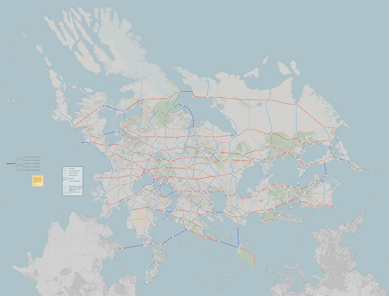
| | '''Idea:''' More than 40 routes patterns have been defined across Uletha following a grid, labeling routes based on the west-east and north-south axes. The routes run across Uletha connecting control cities (at least one per territory). The exact route on the map is to be defined by the mappers involved between the control cities, whereas this numbering scheme is merely a guide. Mappers are also welcome to define routes which can connect areas and settlements not covered by the scheme. |
|
| |
|
| {| style="width: 80%; margin: 0 0 0 10%; border-collapse: collapse; background: #FFFFFF; border: 1px solid #aaa; border-left: 10px solid #87a619;" | | {| |
| |-
| | |- |
| | style="width: 52px; padding: 2px 0px 2px 0.5em; text-align: center;" | [[File:Landscape.svg|40px]] | | | style="background:#b0ffe7; border:1px solid #b0ffe7; padding:1em; margin:auto;"|[[File:Codex icon map color-base.svg|30px]] The image of the proposal can be found at the following '''[https://i.postimg.cc/T1rdZSm7/Ulethan-Routes.png link]''', hosted externally due to the large size of the file. |
| | style="padding: 0.25em 0.5em;" | '''Landscape''' <br/>
| | |- |
| |}
| |
| {| style="width: 80%; margin: 0 0 0 10%; border-collapse: collapse; background: #FBFBFB; border: 1px solid #aaa; border-left: 10px solid #f4c430;"
| |
| |-
| |
| | style="width: 52px; padding: 2px 0px 2px 0.5em; text-align: center;" | [[File:Draw raining.png|40px]]
| |
| | style="padding: 0.25em 0.5em;" | '''Climate'''<br/>
| |
| |}
| |
| {| style="width: 80%; margin: 0 0 0 10%; border-collapse: collapse; background: #FBFBFB; border: 1px solid #aaa; border-left: 10px solid #1e90ff;"
| |
| |-
| |
| | style="width: 52px; padding: 2px 0px 2px 0.5em; text-align: center;" | [[File:HSTheatre.svg|40px]]<br>[[File:HSA.png|40px]]
| |
| | style="padding: 0.25em 0.5em;" | '''Culture & language''' <br/>
| |
| |}
| |
| {| style="width: 80%; margin: 0 0 0 10%; border-collapse: collapse; background: #FBFBFB; border: 1px solid #aaa; border-left: 10px solid #197ba6;"
| |
| |-
| |
| | style="width: 52px; padding: 2px 0px 2px 0.5em; text-align: center;" | [[File:HSHistory.svg|40px]]
| |
| | style="padding: 0.25em 0.5em;" | '''History''' <br/>
| |
| |}
| |
| {| style="width: 80%; margin: 0 0 0 10%; border-collapse: collapse; background: #FBFBFB; border: 1px solid #aaa; border-left: 10px solid #9ca8ad;"
| |
| |-
| |
| | style="width: 52px; padding: 2px 0px 2px 0.5em; text-align: center;" | [[File:Flag of Iran.svg|border|40px]]<br>[[File:Flag of India.svg|border|40px]]
| |
| | style="padding: 0.25em 0.5em;" | '''Homelands''' <br/> This region is home to the Aryan (Persian) and Hindi (broadly)(currently unnamed) cultures.
| |
| |} | | |} |
|
| |
|
| === Mediviria (07) ===
| | '''Rules and guidelines:''' |
| | *Lore-wise, the scheme was created by [[ASUN]] in West Uletha, and the plan spans the entirety of Uletha, East and West. Whether East Uletha ([[East Ulethan Organization of Intergovernmental Associates|EUOIA]]) recognizes this effort, or not, the scheme is in place. ''This is mimicking the E-road system which encompasses the entirety of Europe and parts of Asia, regardless of the socio-political climate in the area.'' |
| | *The scheme/proposal is <span style="color:#ff0026">non-binding</span>, meaning no country is required to adopt it. |
| | *The scheme defines A-class and B-class routes, whereas all users are welcome to 'fill in the gaps' by defining C-routes with their neighbors. |
| | *The numbering scheme is <span style="color:#ff0026">'''Uxx'''</span>, where ''xx'' is a specific route, such as U5, U25, or U251. No hyphens or other symbols are present. |
|
| |
|
| {| style="width: 80%; margin: 0 0 0 10%; border-collapse: collapse; background: #FFFFFF; border: 1px solid #aaa; border-left: 10px solid #87a619;" | | {| |
| |-
| | |- |
| | style="width: 52px; padding: 2px 0px 2px 0.5em; text-align: center;" | [[File:Landscape.svg|40px]] | | | style="background:#fff9e3; border:1px solid #d6ab00; padding:1em; margin:auto;"| |
| | style="padding: 0.25em 0.5em;" | '''Landscape''' <br/> | | '''How to map:''' |
| |}
| | *If a mapper chooses to adopt this scheme within their territory, and wishes to have the route numbers render, they can do so by tagging the affected roads with: |
| {| style="width: 80%; margin: 0 0 0 10%; border-collapse: collapse; background: #FBFBFB; border: 1px solid #aaa; border-left: 10px solid #f4c430;"
| | **<code>ref=*</code>, where * indicates the appropriate route number, e.g. <code>ref=U25</code>. Since countries have their own national numbering schemes, this can be done by including both route numbers in the same tag, e.g. <code>ref=A1;U25</code>, which will render the former number above the latter. |
| |-
| | *If a mapper chooses to adopt this scheme within their territory, but wishes <span style="color:#ff0026">'''not'''</span> to have the route numbers render alongside their national numbers (one of the reasons being they find the tags too cluttered together), they don't have to alter the ref tags. |
| | style="width: 52px; padding: 2px 0px 2px 0.5em; text-align: center;" | [[File:Draw raining.png|40px]]
| | <br> |
| | style="padding: 0.25em 0.5em;" | '''Climate'''<br/>
| | :In either case, it is best to create a relation for each route within a territory, and including the roads as the relation members. A good example of how to do that is the '''[https://opengeofiction.net/relation/524889 following relation]'''. The relation itself should feature the following tags: |
| |}
| | **<code>type=route</code> - Defining that it is a route-type relation |
| {| style="width: 80%; margin: 0 0 0 10%; border-collapse: collapse; background: #FBFBFB; border: 1px solid #aaa; border-left: 10px solid #1e90ff;"
| | **<code>route=road</code> - Defining that the route is a road |
| |- | | **<code>network=U-road</code> - Defining the network itself, required for the renderer to match the shield design |
| | style="width: 52px; padding: 2px 0px 2px 0.5em; text-align: center;" | [[File:HSTheatre.svg|40px]]<br>[[File:HSA.png|40px]]
| | **<code>ref=*</code> - The route number in the format: UXX, where XX is the route number, e.g. U10 |
| | style="padding: 0.25em 0.5em;" | '''Culture & language''' <br/>
| | **<code>name=*</code> - A custom name of the route, usually in the format: Ulethan route U10 (Country), noting which country is the relation located in |
| |}
| | :Other tags are welcome but not required. |
| {| style="width: 80%; margin: 0 0 0 10%; border-collapse: collapse; background: #FBFBFB; border: 1px solid #aaa; border-left: 10px solid #197ba6;"
| | |- |
| |-
| |
| | style="width: 52px; padding: 2px 0px 2px 0.5em; text-align: center;" | [[File:HSHistory.svg|40px]]
| |
| | style="padding: 0.25em 0.5em;" | '''History''' <br/>
| |
| |}
| |
| {| style="width: 80%; margin: 0 0 0 10%; border-collapse: collapse; background: #FBFBFB; border: 1px solid #aaa; border-left: 10px solid #9ca8ad;"
| |
| |-
| |
| | style="width: 52px; padding: 2px 0px 2px 0.5em; text-align: center;" | [[File:Flag of the Organization of Turkic States.svg|border|40px]]<br>[[File:Flag of Turkey.svg|border|40px]]<br>[[File:Flag of Uzbekistan.svg|border|40px]]<br>[[File:Flag of Israel.svg|border|40px]]
| |
| | style="padding: 0.25em 0.5em;" | '''Homelands''' <br/> This region is home of the Turkic cultures, including but not limited to Turquese (Turkish), Yughut* (Uzbek) and ''Naphonan(?)'' (Hebrew).
| |
| |}
| |
| <nowiki>* - ''Yughut (Uzbek) is </nowiki>noted on the [[Index:Languages]] wiki page, but is not present in any territory as a dominant culture.''
| |
| === ''Romanthia'' (08) ===
| |
| | |
| {| style="width: 80%; margin: 0 0 0 10%; border-collapse: collapse; background: #FFFFFF; border: 1px solid #aaa; border-left: 10px solid #87a619;"
| |
| |-
| |
| | style="width: 52px; padding: 2px 0px 2px 0.5em; text-align: center;" | [[File:Landscape.svg|40px]]
| |
| | style="padding: 0.25em 0.5em;" | '''Landscape''' <br/>
| |
| |}
| |
| {| style="width: 80%; margin: 0 0 0 10%; border-collapse: collapse; background: #FBFBFB; border: 1px solid #aaa; border-left: 10px solid #f4c430;"
| |
| |-
| |
| | style="width: 52px; padding: 2px 0px 2px 0.5em; text-align: center;" | [[File:Draw raining.png|40px]]
| |
| | style="padding: 0.25em 0.5em;" | '''Climate'''<br/>
| |
| |}
| |
| {| style="width: 80%; margin: 0 0 0 10%; border-collapse: collapse; background: #FBFBFB; border: 1px solid #aaa; border-left: 10px solid #1e90ff;"
| |
| |-
| |
| | style="width: 52px; padding: 2px 0px 2px 0.5em; text-align: center;" | [[File:HSTheatre.svg|40px]]<br>[[File:HSA.png|40px]]
| |
| | style="padding: 0.25em 0.5em;" | '''Culture & language''' <br/>
| |
| |}
| |
| {| style="width: 80%; margin: 0 0 0 10%; border-collapse: collapse; background: #FBFBFB; border: 1px solid #aaa; border-left: 10px solid #197ba6;"
| |
| |-
| |
| | style="width: 52px; padding: 2px 0px 2px 0.5em; text-align: center;" | [[File:HSHistory.svg|40px]]
| |
| | style="padding: 0.25em 0.5em;" | '''History''' <br/>
| |
| |}
| |
| {| style="width: 80%; margin: 0 0 0 10%; border-collapse: collapse; background: #FBFBFB; border: 1px solid #aaa; border-left: 10px solid #9ca8ad;"
| |
| |-
| |
| | style="width: 52px; padding: 2px 0px 2px 0.5em; text-align: center;" | [[File:Flag of Vatican City.svg|border|40px]]<br>[[File:Flag of France.svg|border|40px]]<br>[[File:Flag of Italy.svg|border|40px]]<br>[[File:Flag of Raetia.svg|border|40px]]<br>[[File:Flag of Venice.svg|border|40px]]
| |
| | style="padding: 0.25em 0.5em;" | '''Homelands''' <br/> This region is home of the Romantish (Latin) cultural group and some of its subgroups, including Franquese (French), Plevian (Italian), Rhaeto-Roman, Navennan (Venetian), alongside various other cultural groups.
| |
| |}
| |
| | |
| === North Hesperic Coast (09) ===
| |
| | |
| {| style="width: 80%; margin: 0 0 0 10%; border-collapse: collapse; background: #FFFFFF; border: 1px solid #aaa; border-left: 10px solid #87a619;"
| |
| |-
| |
| | style="width: 52px; padding: 2px 0px 2px 0.5em; text-align: center;" | [[File:Landscape.svg|40px]]
| |
| | style="padding: 0.25em 0.5em;" | '''Landscape''' <br/>
| |
| |}
| |
| {| style="width: 80%; margin: 0 0 0 10%; border-collapse: collapse; background: #FBFBFB; border: 1px solid #aaa; border-left: 10px solid #f4c430;"
| |
| |-
| |
| | style="width: 52px; padding: 2px 0px 2px 0.5em; text-align: center;" | [[File:Draw raining.png|40px]]
| |
| | style="padding: 0.25em 0.5em;" | '''Climate'''<br/>
| |
| |}
| |
| {| style="width: 80%; margin: 0 0 0 10%; border-collapse: collapse; background: #FBFBFB; border: 1px solid #aaa; border-left: 10px solid #1e90ff;"
| |
| |-
| |
| | style="width: 52px; padding: 2px 0px 2px 0.5em; text-align: center;" | [[File:HSTheatre.svg|40px]]<br>[[File:HSA.png|40px]]
| |
| | style="padding: 0.25em 0.5em;" | '''Culture & language''' <br/>
| |
| |}
| |
| {| style="width: 80%; margin: 0 0 0 10%; border-collapse: collapse; background: #FBFBFB; border: 1px solid #aaa; border-left: 10px solid #197ba6;"
| |
| |-
| |
| | style="width: 52px; padding: 2px 0px 2px 0.5em; text-align: center;" | [[File:HSHistory.svg|40px]]
| |
| | style="padding: 0.25em 0.5em;" | '''History''' <br/>
| |
| |}
| |
| {| style="width: 80%; margin: 0 0 0 10%; border-collapse: collapse; background: #FBFBFB; border: 1px solid #aaa; border-left: 10px solid #9ca8ad;"
| |
| |-
| |
| | style="width: 52px; padding: 2px 0px 2px 0.5em; text-align: center;" | [[File:Flag of Germany.svg|border|40px]]
| |
| | style="padding: 0.25em 0.5em;" | '''Homelands''' <br/> This region is home of the Kalmish (German) culture.
| |
| |}
| |
| | |
| === Wallentha (10) ===
| |
| | |
| {| style="width: 80%; margin: 0 0 0 10%; border-collapse: collapse; background: #FFFFFF; border: 1px solid #aaa; border-left: 10px solid #87a619;"
| |
| |-
| |
| | style="width: 52px; padding: 2px 0px 2px 0.5em; text-align: center;" | [[File:Landscape.svg|40px]]
| |
| | style="padding: 0.25em 0.5em;" | '''Landscape''' <br/>
| |
| |}
| |
| {| style="width: 80%; margin: 0 0 0 10%; border-collapse: collapse; background: #FBFBFB; border: 1px solid #aaa; border-left: 10px solid #f4c430;"
| |
| |-
| |
| | style="width: 52px; padding: 2px 0px 2px 0.5em; text-align: center;" | [[File:Draw raining.png|40px]]
| |
| | style="padding: 0.25em 0.5em;" | '''Climate'''<br/>
| |
| |}
| |
| {| style="width: 80%; margin: 0 0 0 10%; border-collapse: collapse; background: #FBFBFB; border: 1px solid #aaa; border-left: 10px solid #1e90ff;"
| |
| |-
| |
| | style="width: 52px; padding: 2px 0px 2px 0.5em; text-align: center;" | [[File:HSTheatre.svg|40px]]<br>[[File:HSA.png|40px]]
| |
| | style="padding: 0.25em 0.5em;" | '''Culture & language''' <br/>
| |
| |}
| |
| {| style="width: 80%; margin: 0 0 0 10%; border-collapse: collapse; background: #FBFBFB; border: 1px solid #aaa; border-left: 10px solid #197ba6;"
| |
| |-
| |
| | style="width: 52px; padding: 2px 0px 2px 0.5em; text-align: center;" | [[File:HSHistory.svg|40px]]
| |
| | style="padding: 0.25em 0.5em;" | '''History''' <br/>
| |
| |}
| |
| {| style="width: 80%; margin: 0 0 0 10%; border-collapse: collapse; background: #FBFBFB; border: 1px solid #aaa; border-left: 10px solid #9ca8ad;"
| |
| |-
| |
| | style="width: 52px; padding: 2px 0px 2px 0.5em; text-align: center;" | [[File:Flag of England.svg|border|40px]]
| |
| | style="padding: 0.25em 0.5em;" | '''Homelands''' <br/> This region is home of the Ingerish* (English) culture.
| |
| |}
| |
| <nowiki>* - Name is undergoing potential change </nowiki>
| |
| === Hetzer-Morcanol (11) ===
| |
| | |
| {| style="width: 80%; margin: 0 0 0 10%; border-collapse: collapse; background: #FFFFFF; border: 1px solid #aaa; border-left: 10px solid #87a619;"
| |
| |-
| |
| | style="width: 52px; padding: 2px 0px 2px 0.5em; text-align: center;" | [[File:Landscape.svg|40px]]
| |
| | style="padding: 0.25em 0.5em;" | '''Landscape''' <br/>
| |
| |}
| |
| {| style="width: 80%; margin: 0 0 0 10%; border-collapse: collapse; background: #FBFBFB; border: 1px solid #aaa; border-left: 10px solid #f4c430;"
| |
| |-
| |
| | style="width: 52px; padding: 2px 0px 2px 0.5em; text-align: center;" | [[File:Draw raining.png|40px]]
| |
| | style="padding: 0.25em 0.5em;" | '''Climate'''<br/>
| |
| |}
| |
| {| style="width: 80%; margin: 0 0 0 10%; border-collapse: collapse; background: #FBFBFB; border: 1px solid #aaa; border-left: 10px solid #1e90ff;"
| |
| |-
| |
| | style="width: 52px; padding: 2px 0px 2px 0.5em; text-align: center;" | [[File:HSTheatre.svg|40px]]<br>[[File:HSA.png|40px]]
| |
| | style="padding: 0.25em 0.5em;" | '''Culture & language''' <br/>
| |
| |}
| |
| {| style="width: 80%; margin: 0 0 0 10%; border-collapse: collapse; background: #FBFBFB; border: 1px solid #aaa; border-left: 10px solid #197ba6;"
| |
| |-
| |
| | style="width: 52px; padding: 2px 0px 2px 0.5em; text-align: center;" | [[File:HSHistory.svg|40px]]
| |
| | style="padding: 0.25em 0.5em;" | '''History''' <br/>
| |
| |}
| |
| {| style="width: 80%; margin: 0 0 0 10%; border-collapse: collapse; background: #FBFBFB; border: 1px solid #aaa; border-left: 10px solid #9ca8ad;"
| |
| |-
| |
| | style="width: 52px; padding: 2px 0px 2px 0.5em; text-align: center;" | [[File:Combined flag of the Celtic nations.svg|border|40px]][[File:Flag of Wales.svg|border|40px]]<br>[[File:Flag of Ireland.svg|border|40px]]<br>[[File:Flag of Netherlands.svg|border|40px]]
| |
| | style="padding: 0.25em 0.5em;" | '''Homelands''' <br/> This region is home of the Celtic language group including Cambric (Welsh) and Irish. Alongside those, the Lentian (Dutch) culture calls this region home.
| |
| |}
| |
| | |
| === West Ulethan Subarctic (12) ===
| |
| | |
| {| style="width: 80%; margin: 0 0 0 10%; border-collapse: collapse; background: #FFFFFF; border: 1px solid #aaa; border-left: 10px solid #87a619;"
| |
| |-
| |
| | style="width: 52px; padding: 2px 0px 2px 0.5em; text-align: center;" | [[File:Landscape.svg|40px]]
| |
| | style="padding: 0.25em 0.5em;" | '''Landscape''' <br/>
| |
| |}
| |
| {| style="width: 80%; margin: 0 0 0 10%; border-collapse: collapse; background: #FBFBFB; border: 1px solid #aaa; border-left: 10px solid #f4c430;"
| |
| |-
| |
| | style="width: 52px; padding: 2px 0px 2px 0.5em; text-align: center;" | [[File:Draw raining.png|40px]]
| |
| | style="padding: 0.25em 0.5em;" | '''Climate'''<br/>
| |
| |}
| |
| {| style="width: 80%; margin: 0 0 0 10%; border-collapse: collapse; background: #FBFBFB; border: 1px solid #aaa; border-left: 10px solid #1e90ff;"
| |
| |-
| |
| | style="width: 52px; padding: 2px 0px 2px 0.5em; text-align: center;" | [[File:HSTheatre.svg|40px]]<br>[[File:HSA.png|40px]]
| |
| | style="padding: 0.25em 0.5em;" | '''Culture & language''' <br/>
| |
| |}
| |
| {| style="width: 80%; margin: 0 0 0 10%; border-collapse: collapse; background: #FBFBFB; border: 1px solid #aaa; border-left: 10px solid #197ba6;"
| |
| |-
| |
| | style="width: 52px; padding: 2px 0px 2px 0.5em; text-align: center;" | [[File:HSHistory.svg|40px]]
| |
| | style="padding: 0.25em 0.5em;" | '''History''' <br/>
| |
| |}
| |
| {| style="width: 80%; margin: 0 0 0 10%; border-collapse: collapse; background: #FBFBFB; border: 1px solid #aaa; border-left: 10px solid #9ca8ad;"
| |
| |-
| |
| | style="width: 52px; padding: 2px 0px 2px 0.5em; text-align: center;" | [[File:Flag of Greenland.svg|border|40px]]<br>[[File:Sami flag.svg|border|40px]]<br>[[File:Flag of Iceland.svg|border|40px]]<br>[[File:Flag of Denmark.svg|border|40px]]<br>[[File:Flag of Sweden.svg|border|40px]]<br>[[File:Flag of Finland.svg|border|40px]]
| |
| | style="padding: 0.25em 0.5em;" | '''Homelands''' <br/> This region is home of the Greenlandic, Gaskúšillimigiella (Pitä/Arjeplog Sámi), Jiemiesillimigiella (Northern Sámi), Norlensk (Icelandic), Danish and Svennish* (Swedish) cultures, alongside numerous other smaller groups. It also features the Finnish culture.
| |
| |}
| |
| <nowiki>* - ''Svennish (Swedish) is </nowiki>originates in this region, but is not the dominant culture in any territory.''
| |
| | |
| === Western Glynia (13) ===
| |
| | |
| {| style="width: 80%; margin: 0 0 0 10%; border-collapse: collapse; background: #FFFFFF; border: 1px solid #aaa; border-left: 10px solid #87a619;"
| |
| |-
| |
| | style="width: 52px; padding: 2px 0px 2px 0.5em; text-align: center;" | [[File:Landscape.svg|40px]]
| |
| | style="padding: 0.25em 0.5em;" | '''Landscape''' <br/>
| |
| |}
| |
| {| style="width: 80%; margin: 0 0 0 10%; border-collapse: collapse; background: #FBFBFB; border: 1px solid #aaa; border-left: 10px solid #f4c430;"
| |
| |-
| |
| | style="width: 52px; padding: 2px 0px 2px 0.5em; text-align: center;" | [[File:Draw raining.png|40px]]
| |
| | style="padding: 0.25em 0.5em;" | '''Climate'''<br/>
| |
| |}
| |
| {| style="width: 80%; margin: 0 0 0 10%; border-collapse: collapse; background: #FBFBFB; border: 1px solid #aaa; border-left: 10px solid #1e90ff;"
| |
| |-
| |
| | style="width: 52px; padding: 2px 0px 2px 0.5em; text-align: center;" | [[File:HSTheatre.svg|40px]]<br>[[File:HSA.png|40px]]
| |
| | style="padding: 0.25em 0.5em;" | '''Culture & language''' <br/>
| |
| |}
| |
| {| style="width: 80%; margin: 0 0 0 10%; border-collapse: collapse; background: #FBFBFB; border: 1px solid #aaa; border-left: 10px solid #197ba6;"
| |
| |-
| |
| | style="width: 52px; padding: 2px 0px 2px 0.5em; text-align: center;" | [[File:HSHistory.svg|40px]]
| |
| | style="padding: 0.25em 0.5em;" | '''History''' <br/>
| |
| |}
| |
| {| style="width: 80%; margin: 0 0 0 10%; border-collapse: collapse; background: #FBFBFB; border: 1px solid #aaa; border-left: 10px solid #9ca8ad;"
| |
| |-
| |
| | style="width: 52px; padding: 2px 0px 2px 0.5em; text-align: center;" | [[File:Flag of Poland.svg|border|40px]]
| |
| | style="padding: 0.25em 0.5em;" | '''Homelands''' <br/> This region is home of the Lechian (Polish) culture.
| |
| |}
| |
| | |
| === Eastern Glynia (14) ===
| |
| | |
| {| style="width: 80%; margin: 0 0 0 10%; border-collapse: collapse; background: #FFFFFF; border: 1px solid #aaa; border-left: 10px solid #87a619;"
| |
| |-
| |
| | style="width: 52px; padding: 2px 0px 2px 0.5em; text-align: center;" | [[File:Landscape.svg|40px]]
| |
| | style="padding: 0.25em 0.5em;" | '''Landscape''' <br/>
| |
| |}
| |
| {| style="width: 80%; margin: 0 0 0 10%; border-collapse: collapse; background: #FBFBFB; border: 1px solid #aaa; border-left: 10px solid #f4c430;"
| |
| |-
| |
| | style="width: 52px; padding: 2px 0px 2px 0.5em; text-align: center;" | [[File:Draw raining.png|40px]]
| |
| | style="padding: 0.25em 0.5em;" | '''Climate'''<br/>
| |
| |}
| |
| {| style="width: 80%; margin: 0 0 0 10%; border-collapse: collapse; background: #FBFBFB; border: 1px solid #aaa; border-left: 10px solid #1e90ff;"
| |
| |-
| |
| | style="width: 52px; padding: 2px 0px 2px 0.5em; text-align: center;" | [[File:HSTheatre.svg|40px]]<br>[[File:HSA.png|40px]]
| |
| | style="padding: 0.25em 0.5em;" | '''Culture & language''' <br/>
| |
| |}
| |
| {| style="width: 80%; margin: 0 0 0 10%; border-collapse: collapse; background: #FBFBFB; border: 1px solid #aaa; border-left: 10px solid #197ba6;"
| |
| |-
| |
| | style="width: 52px; padding: 2px 0px 2px 0.5em; text-align: center;" | [[File:HSHistory.svg|40px]]
| |
| | style="padding: 0.25em 0.5em;" | '''History''' <br/>
| |
| |}
| |
| {| style="width: 80%; margin: 0 0 0 10%; border-collapse: collapse; background: #FBFBFB; border: 1px solid #aaa; border-left: 10px solid #9ca8ad;"
| |
| |-
| |
| | style="width: 52px; padding: 2px 0px 2px 0.5em; text-align: center;" | [[File:Flag of Estonia.svg|border|40px]]<Br>[[File:Flag of Ukraine.svg|border|40px]]<br>[[File:Flag of Silesia.svg|border|40px]]<br>[[File:Finno-Ugric language.gif|border|40px]]
| |
| | style="padding: 0.25em 0.5em;" | '''Homelands''' <br/> This region is home of the Saave (Estonian), (Dregolesian) Ukrainian, and Silesian cultures, as well as being partly the origin of the Baltic and Uralic groups.
| |
| |}
| |
| | |
| === Egalia (15) ===
| |
| | |
| {| style="width: 80%; margin: 0 0 0 10%; border-collapse: collapse; background: #FFFFFF; border: 1px solid #aaa; border-left: 10px solid #87a619;"
| |
| |-
| |
| | style="width: 52px; padding: 2px 0px 2px 0.5em; text-align: center;" | [[File:Landscape.svg|40px]]
| |
| | style="padding: 0.25em 0.5em;" | '''Landscape''' <br/>
| |
| |}
| |
| {| style="width: 80%; margin: 0 0 0 10%; border-collapse: collapse; background: #FBFBFB; border: 1px solid #aaa; border-left: 10px solid #f4c430;"
| |
| |-
| |
| | style="width: 52px; padding: 2px 0px 2px 0.5em; text-align: center;" | [[File:Draw raining.png|40px]]
| |
| | style="padding: 0.25em 0.5em;" | '''Climate'''<br/>
| |
| |}
| |
| {| style="width: 80%; margin: 0 0 0 10%; border-collapse: collapse; background: #FBFBFB; border: 1px solid #aaa; border-left: 10px solid #1e90ff;"
| |
| |-
| |
| | style="width: 52px; padding: 2px 0px 2px 0.5em; text-align: center;" | [[File:HSTheatre.svg|40px]]<br>[[File:HSA.png|40px]]
| |
| | style="padding: 0.25em 0.5em;" | '''Culture & language''' <br/>
| |
| |}
| |
| {| style="width: 80%; margin: 0 0 0 10%; border-collapse: collapse; background: #FBFBFB; border: 1px solid #aaa; border-left: 10px solid #197ba6;"
| |
| |-
| |
| | style="width: 52px; padding: 2px 0px 2px 0.5em; text-align: center;" | [[File:HSHistory.svg|40px]]
| |
| | style="padding: 0.25em 0.5em;" | '''History''' <br/>
| |
| |}
| |
| {| style="width: 80%; margin: 0 0 0 10%; border-collapse: collapse; background: #FBFBFB; border: 1px solid #aaa; border-left: 10px solid #9ca8ad;"
| |
| |-
| |
| | style="width: 52px; padding: 2px 0px 2px 0.5em; text-align: center;" | [[File:Flag of Serbia.svg|border|40px]]<br>[[File:Flag of Croatia.svg|border|40px]]<br>[[File:Flag of Czechia.svg|border|40px]]<br>[[File:Flag of Slovenia.svg|border|40px]]<br>[[File:Flag of North Macedonia.svg|border|40px]]<br>[[File:Flag of Belarus (1918, 1991–1995).svg|border|40px]]<br>[[File:Flag of Hungary.svg|border|40px]]<br>[[File:Kraljevina Jugoslavija (16–9).svg|border|40px]]
| |
| | style="padding: 0.25em 0.5em;" | '''Homelands''' <br/> This region is home of numerous Slavic languages and cultures, including Livnian (Serbian), Mallyorian (Croatian), Drabantian (Czech), Beldonian (Slovene), Macedonian, Dregovinian (based on Belarusian), Podolian (Slavic conlang). Alongside that, it is also the homeland of Hungarian. It is potentially the homeland of the Slavic cultural group.
| |
| |}
| |
| | |
| === Suria (16) ===
| |
| | |
| {| style="width: 80%; margin: 0 0 0 10%; border-collapse: collapse; background: #FFFFFF; border: 1px solid #aaa; border-left: 10px solid #87a619;"
| |
| |-
| |
| | style="width: 52px; padding: 2px 0px 2px 0.5em; text-align: center;" | [[File:Landscape.svg|40px]]
| |
| | style="padding: 0.25em 0.5em;" | '''Landscape''' <br/>
| |
| |}
| |
| {| style="width: 80%; margin: 0 0 0 10%; border-collapse: collapse; background: #FBFBFB; border: 1px solid #aaa; border-left: 10px solid #f4c430;"
| |
| |-
| |
| | style="width: 52px; padding: 2px 0px 2px 0.5em; text-align: center;" | [[File:Draw raining.png|40px]]
| |
| | style="padding: 0.25em 0.5em;" | '''Climate'''<br/>
| |
| |}
| |
| {| style="width: 80%; margin: 0 0 0 10%; border-collapse: collapse; background: #FBFBFB; border: 1px solid #aaa; border-left: 10px solid #1e90ff;"
| |
| |-
| |
| | style="width: 52px; padding: 2px 0px 2px 0.5em; text-align: center;" | [[File:HSTheatre.svg|40px]]<br>[[File:HSA.png|40px]]
| |
| | style="padding: 0.25em 0.5em;" | '''Culture & language''' <br/>
| |
| |}
| |
| {| style="width: 80%; margin: 0 0 0 10%; border-collapse: collapse; background: #FBFBFB; border: 1px solid #aaa; border-left: 10px solid #197ba6;"
| |
| |-
| |
| | style="width: 52px; padding: 2px 0px 2px 0.5em; text-align: center;" | [[File:HSHistory.svg|40px]]
| |
| | style="padding: 0.25em 0.5em;" | '''History''' <br/>
| |
| |}
| |
| {| style="width: 80%; margin: 0 0 0 10%; border-collapse: collapse; background: #FBFBFB; border: 1px solid #aaa; border-left: 10px solid #9ca8ad;"
| |
| |-
| |
| | style="width: 52px; padding: 2px 0px 2px 0.5em; text-align: center;" | [[File:Flag of Russia.svg|border|40px]]<br>[[File:Flag of Georgia.svg|border|40px]]<br>[[File:Kraljevina Jugoslavija (16–9).svg|border|40px]]
| |
| | style="padding: 0.25em 0.5em;" | '''Homelands''' <br/> This region is home of the Surian (Russian) culture. Likewise, it is partially the homeland of the Kartvelian (Georgian) culture. It is potentially the homeland of the Slavic cultural group.
| |
| |}
| |
| | |
| === Iviran Coast (17) ===
| |
| | |
| {| style="width: 80%; margin: 0 0 0 10%; border-collapse: collapse; background: #FFFFFF; border: 1px solid #aaa; border-left: 10px solid #87a619;"
| |
| |-
| |
| | style="width: 52px; padding: 2px 0px 2px 0.5em; text-align: center;" | [[File:Landscape.svg|40px]]
| |
| | style="padding: 0.25em 0.5em;" | '''Landscape''' <br/>
| |
| |}
| |
| {| style="width: 80%; margin: 0 0 0 10%; border-collapse: collapse; background: #FBFBFB; border: 1px solid #aaa; border-left: 10px solid #f4c430;"
| |
| |- | |
| | style="width: 52px; padding: 2px 0px 2px 0.5em; text-align: center;" | [[File:Draw raining.png|40px]]
| |
| | style="padding: 0.25em 0.5em;" | '''Climate'''<br/>
| |
| |}
| |
| {| style="width: 80%; margin: 0 0 0 10%; border-collapse: collapse; background: #FBFBFB; border: 1px solid #aaa; border-left: 10px solid #1e90ff;"
| |
| |-
| |
| | style="width: 52px; padding: 2px 0px 2px 0.5em; text-align: center;" | [[File:HSTheatre.svg|40px]]<br>[[File:HSA.png|40px]]
| |
| | style="padding: 0.25em 0.5em;" | '''Culture & language''' <br/>
| |
| |}
| |
| {| style="width: 80%; margin: 0 0 0 10%; border-collapse: collapse; background: #FBFBFB; border: 1px solid #aaa; border-left: 10px solid #197ba6;"
| |
| |-
| |
| | style="width: 52px; padding: 2px 0px 2px 0.5em; text-align: center;" | [[File:HSHistory.svg|40px]]
| |
| | style="padding: 0.25em 0.5em;" | '''History''' <br/>
| |
| |}
| |
| {| style="width: 80%; margin: 0 0 0 10%; border-collapse: collapse; background: #FBFBFB; border: 1px solid #aaa; border-left: 10px solid #9ca8ad;"
| |
| |-
| |
| | style="width: 52px; padding: 2px 0px 2px 0.5em; text-align: center;" | [[File:Flag of Albania.svg|border|40px]]<br>[[File:Flag of Romania.svg|border|40px]]<br>[[File:Flag_of_Iviron.png|border|40px]]<br>[[File:Flag of Georgia.svg|border|40px]]
| |
| | style="padding: 0.25em 0.5em;" | '''Homelands''' <br/> This region is home of the Albanian culture, as well as numerous conlang cultures such as Iviran. It is partially home to the Kartvelian (Georgian) culture.
| |
| |} | | |} |
|
| |
|
| |
|
| [[Category:West Uletha]] | | [[Category:West Uletha]] |

 Rough elevation and terrain map
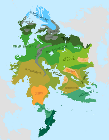 Biomes map
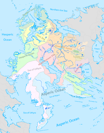 Major rivers and drainage basins map
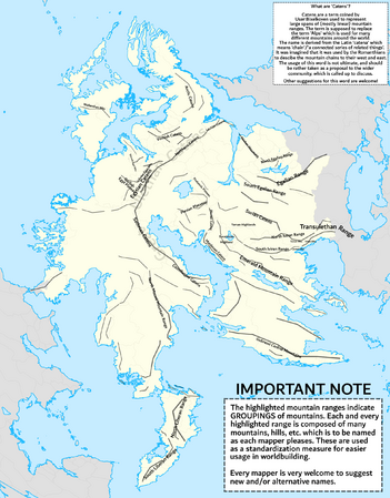 Mountain ranges map
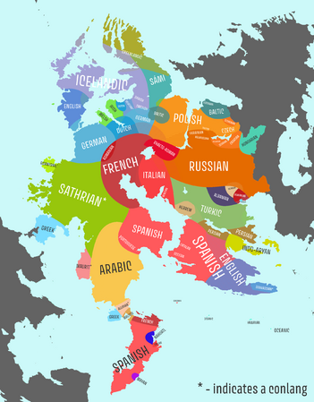 Map of currently predominant languages in each area
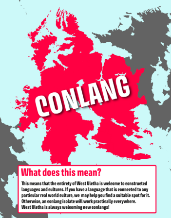


 Ghetoria
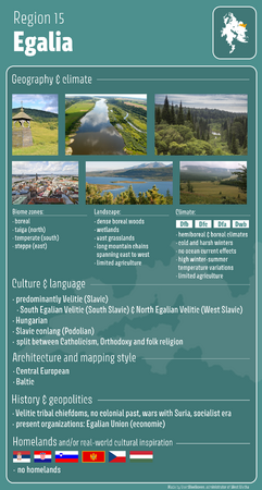 Egalia
