Index:States of the Federal States: Difference between revisions
Adding Wisecota, fixing alphabetical order |
mNo edit summary |
||
| (24 intermediate revisions by 9 users not shown) | |||
| Line 7: | Line 7: | ||
| collapse = yes | | collapse = yes | ||
}}{{clear}} | }}{{clear}} | ||
{{Snapshot FS state | {{Snapshot FS state | ||
| name = Alormen | | name = Alormen | ||
| Line 65: | Line 64: | ||
| other-metros = {{node|189155376|Gainesboro}} | | other-metros = {{node|189155376|Gainesboro}} | ||
| relation_id = 90157 | | relation_id = 90157 | ||
| neighbors = {{Riopoderos}}, {{Sierra}} | | neighbors = {{Des Plaines}}, {{Riopoderos}}, {{Sierra}} | ||
| img-bird = | | img-bird = Colaptes rupicola 20070123.jpg | ||
| cap-bird = | | cap-bird = Cordilleran flicker | ||
| img-flower = | | img-flower = Black cohosh 2.jpg | ||
| cap-flower = | | cap-flower = Black cohosh | ||
| img-tree = | | img-tree = Bomarea salsilla.jpg | ||
| cap-tree = | | cap-tree = ''Bomarea salsilla'' | ||
| img-license = | | img-license = Araucaria en Parque Nacional Conguillio.jpg | ||
| cap-license = | | cap-license = Pehuén | ||
| img-shield = AWshield.svg | | img-shield = AWshield.svg | ||
| cap-shield = Standard state highway shield | | cap-shield = Standard state highway shield | ||
| img-custom1 = 5aday sweet potato.jpg | |||
| cap-custom1 = Sweet potato (state vegetable) | |||
| img-custom2 = Mixed Apples for Cider Pressing.jpg | |||
| cap-custom2 = Wagnuka apple (state fruit) | |||
| img-custom3 = Apfelwein Geripptes Bembel.jpg | |||
| cap-custom3 = Apple cider (state drink) | |||
}} | }} | ||
| Line 105: | Line 110: | ||
| cap-shield = Clamash State Highway Sign | | cap-shield = Clamash State Highway Sign | ||
}} | }} | ||
{{Snapshot FS state | |||
| name = Des Plaines | |||
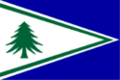
| flag = Flag of Des Plaines.png | |||
| region = Heartland | |||
| capital = {{node|382650356|Steeletown}} | |||
| population = 2,607,104 (2020) | |||
| statehood = 1821 | |||
| etymology = From the colonial Valonian name of the region "Les Aéchantans Indigènes des Plaines", meaning "The Native Archantans of the Plains" in Ingerish | |||
| demonym = Des Plainer | |||
| postal = DP | |||
| motto = "L'agriculture est ce qui nous unit" ("Agriculture is what unites us") | |||
| song = The Golden Fleur-de-lis | |||
| largest-city = Steeletown | |||
| other-metros = Thinis, Skiree City, Ascopolis, Fillmore, Wheatville | |||
| relation_id = 90152 | |||
| neighbors = {{Apawiland}}, {{Mennowa}}, {{Riopoderos}}, {{Tennewa}}, {{West Massodeya}}, AR120-41 | |||
| img-seal = | |||
| cap-seal = | |||
| img-shield = Des Plaines Highway Shield.png | |||
| cap-shield = Highway Shield, Standard | |||
| img-custom1 = Des Plaines Highway Shield Wide.png | |||
| cap-custom1 = Highway Shield, Standard Wide | |||
| img-license= Des Plaines License Plate.png | |||
| cap-license= Des Plaines License Plate | |||
}} | |||
{{Snapshot FS state | {{Snapshot FS state | ||
| name = Illuvia | | name = Illuvia | ||
| Line 163: | Line 195: | ||
| other-metros = Des Nonnes, New Harmony, and Prairie City | | other-metros = Des Nonnes, New Harmony, and Prairie City | ||
| relation_id = 90151 | | relation_id = 90151 | ||
| neighbors = Gnaerey, {{Tennewa}}, [[Wauseka]], {{West Massodeya}}, {{Zakahigan}} | | neighbors = {{Des Plaines}}, Gnaerey, {{Tennewa}}, [[Wauseka]], {{West Massodeya}}, {{Zakahigan}} | ||
| img-bird = Northern cardinal female in CP (02035).jpg | | img-bird = Northern cardinal female in CP (02035).jpg | ||
| cap-bird = Archantan cardinal | | cap-bird = Archantan cardinal | ||
| Line 174: | Line 206: | ||
| img-shield = MennowaShield2di.png | | img-shield = MennowaShield2di.png | ||
| cap-shield = Highway shield, standard | | cap-shield = Highway shield, standard | ||
| img-custom1 = MennowaMotorRoadShield-example.png | |||
| cap-custom1 = Highway shield, historic motor roads | |||
}} | }} | ||
| Line 224: | Line 258: | ||
| img-custom2 = Minnonigan Tollway.png | | img-custom2 = Minnonigan Tollway.png | ||
| cap-custom2 = Highway shield, turnpike | | cap-custom2 = Highway shield, turnpike | ||
}} | |||
{{Snapshot FS state | |||
| name = Mishota | |||
| flag = Mishota flag.svg | |||
| region = West Lakes | |||
| capital = {{node|251228975|Virestrom}} | |||
| population = 2,700,000 (2020) | |||
| statehood = | |||
| etymology = | |||
| demonym = Mishotan | |||
| postal = MI | |||
| motto = | |||
| song = | |||
| largest-city = {{node|383808790|Eriksburg}} | |||
| other-metros = Springfield, Howeather | |||
| relation_id = 89432 | |||
| neighbors = {{Illuvia}}, {{Iroquesia}}, {{Zakahigan}}, {{Mennowa}}, {{Tennewa}} | |||
| img-bird = | |||
| cap-bird = | |||
| img-flower = | |||
| cap-flower = | |||
| img-tree = | |||
| cap-tree = | |||
| img-license = | |||
| cap-license = | |||
| img-shield = | |||
| cap-shield = | |||
| img-custom1 = | |||
| cap-custom1 = | |||
| img-custom2 = | |||
| cap-custom2 = | |||
}} | }} | ||
| Line 278: | Line 344: | ||
| relation_id = 90063 | | relation_id = 90063 | ||
| other-metros = {{node|342615177|Holmes}}, {{node|342615637|Montegoss}} | | other-metros = {{node|342615177|Holmes}}, {{node|342615637|Montegoss}} | ||
|img-shield=OP shield 2digit.png|cap-shield=State route shield}} | |||
{{Snapshot FS state | |||
| name = Orange Coast | |||
| flag = 4_FSA_OrangeCoast.png | |||
| region = Northeast | |||
| capital = [https://opengeofiction.net/#map=14/-36.2983/161.9617&layers=B Bronson City] | |||
| population = 1.189.315 (2025) | |||
| statehood = 1785 | |||
| etymology = Orange farmlands, and beaches | |||
| demonym = Orangian | |||
| postal = OC | |||
| motto = "United Cities and Towns" | |||
| song = | |||
| largest-city = [https://opengeofiction.net/#map=13/-36.0886/162.6473 San Bruno] | |||
| other-metros = Jamesville | |||
| relation_id = 90061 | |||
| neighbors = {{Laine}}, AR120-27, {{Opelika}} | |||
| img-seal = 4_OCLogos.png | |||
| cap-seal = Orangian Seal | |||
| img-license = 4_FSA_OC_LicensePlate.png | |||
| cap-license = Orange Coast license plate | |||
| img-shield = 4_FSA_OC_statehighway.png | |||
| cap-shield = Orange Coast state highway shield | |||
| img-custom1 = FSA_OC_BronsonCity.png | |||
| cap-custom1 = Bronson Vity view | |||
| img-custom2 = FSA_OC_SBC_00.png | |||
| cap-custom2 = San Bruno view | |||
}} | }} | ||
{{Snapshot FS state | {{Snapshot FS state | ||
| name = Passamaqueets | |||
| flag = Flag of Passamaqueets.png | |||
| region = Southeast | |||
| capital = {{node|374423129|Burton}} | |||
| population = 2,547,846 | |||
| etymology = Derived from native name for "Land of the fish" | |||
| postal = PA | |||
| largest-city = Burton | |||
| other-metros = {{node|377655164|Greenville}}, {{node|341801045|Port Mary}},{{node|377655155|Wincheford}} | |||
| neighbors = {{Hyde}}, Oakley, {{Astrantia}}, {{New Carnaby}} (Maritime) | |||
| relation_id = 90782 | |||
| statehood=1639 | |||
| denonym=Passamaqueeter | |||
| img-license = Passamaqueets License plate.png | |||
| cap-license = Standard License Plate | |||
| img-shield = Passamaqueets highway shield.png | |||
| cap-shield = Passamaqueets highway shield | |||
| img-custom1 = Passamaqueets License plate variant.png | |||
| cap-custom1 = License Plate Variant | |||
}} | |||
{{Snapshot FS state|name=Passitania|flag=Passitania-flag.png|region=Massodeya Valley|capital=[[Madawan]]|population=5,562,340 (2020)|largest-city=Catterick|other-metros=Onawanda, Spotswood, Willowbrook|neighbors=Michisaukee, Ardelia, New Carnaby, AR120-37, [[Wauseka]], Gnaerey|postal=PS|relation_id=89775|statehood=1789|denonym=Passitanian|img-shield=Passitania Highway 1.png|cap-shield=Standard highway shield|etymology=Named after being the site of a major mountain pass through the Asphale Mountains}}{{Snapshot FS state | |||
| name = Penquisset | | name = Penquisset | ||
| flag = Penquisset Flag.jpg | | flag = Penquisset Flag.jpg | ||
| Line 340: | Line 457: | ||
| other-metros = Las Animas, Porte Springs | | other-metros = Las Animas, Porte Springs | ||
| relation-id = 90158 | | relation-id = 90158 | ||
| neighbors = {{Apawiland}}, {{Clamash}}, {{Sierra}}, {{Tennewa}}, {{Wychelle}} | | neighbors = {{Apawiland}}, {{Des Plaines}}, {{Clamash}}, {{Sierra}}, {{Tennewa}}, {{Wychelle}} | ||
| img-flower = Mountain_Sun_Daisy.jpg | | img-flower = Mountain_Sun_Daisy.jpg | ||
| cap-flower = The state flower; The Mountain Sun Daisy | | cap-flower = The state flower; The Mountain Sun Daisy | ||
| Line 365: | Line 482: | ||
| largest-city = Dennison | | largest-city = Dennison | ||
| other-metros = Lola, Chapman | | other-metros = Lola, Chapman | ||
| neighbors = Alcortez, {{Apawiland}}, {{Atascadera}}, {{Clamash}}, {{Riopoderos}}, {{Tauhon}} | | neighbors = Alcortez, {{Apawiland}}, {{Atascadera}}, {{Des Plaines}}, {{Clamash}}, {{Riopoderos}}, {{Tauhon}} | ||
| relation_id = | | relation_id = | ||
| img-seal = Seal of Sierra.png | | img-seal = Seal of Sierra.png | ||
| Line 424: | Line 541: | ||
| cap-custom1 = Secondary state highway shield | | cap-custom1 = Secondary state highway shield | ||
}} | }} | ||
{{Snapshot FS state|flag=Flag of Venary.png|name=Venary|neighbors=AR120-56|largest-city={{node|404739896|Conway}}|capital={{node|404739896|Conway}}|region=West Lakes|postal=VE|relation_id=91098|statehood=1828|population=1.600.000 (2020)|motto=Venary, the treasure of the south ''(Venaritenèr, enar milenis)''|demonym=Venarian|etymology=from Venarian ''Venariteknè'', meaning "we, the people near the hills"|other-metros={{node|404739897|Mawkillakin}}, {{node|404739898|Three Streams}}|song=Our Venary, forever ''(Venaritenèrenis, inekawilpare)''}}{{Snapshot FS state | |||
{{Snapshot FS state | |||
| name = West Massodeya | | name = West Massodeya | ||
| flag = WM_flag.png | | flag = WM_flag.png | ||
| region = Massodeyas | | region = Massodeyas | ||
| capital = Caldwell City | | capital = Caldwell City | ||
| population = | | population = 4,478,000 (2021) | ||
| statehood = 1805 | | statehood = 1805 | ||
| etymology = Massodeya River | | etymology = Massodeya River | ||
| Line 440: | Line 556: | ||
| other-metros = Reeseport, Fort Graham | | other-metros = Reeseport, Fort Graham | ||
| relation_id = 90151 | | relation_id = 90151 | ||
| neighbors = {{Alormen}}, East Massodeya, Gnaerey, {{Mennowa}} | | neighbors = {{Alormen}}, {{Des Plaines}}, East Massodeya, Gnaerey, {{Mennowa}} | ||
| img-shield = WM_Shield.png | | img-shield = WM_Shield.png | ||
| cap-shield = Highway shield, standard | | cap-shield = Highway shield, standard | ||
| Line 527: | Line 643: | ||
| cap-custom7 = | | cap-custom7 = | ||
}} | }} | ||
[[Category:States of the Federal States| ]] | [[Category:States of the Federal States| ]] | ||
[[Category:Index pages]] | [[Category:Index pages]] | ||
Latest revision as of 21:04, 1 October 2025
The states of the Federal States are a constituent political entity within the country and shares sovereignty with the federal government. As the country expanded and grew, new states were added to the union. This page provides a snapshot overview of some of the states.
| File:Symbol important note.svg Important technical notes to users |
|---|
| To include a state below, please use {{Snapshot FS state}}. Note that there are required elements for the template to ensure a minimum amount of information (name, flag, region, capital, postal code, etc.). Information about required parameters may be found on the template page. Then, be sure to add the state to the table of contents manually. All states must appear in alphabetical order. |
| | ||
|---|---|---|
| Region: Alormen | Capital: Alamar | Population: 17,500,000 (2020) |
| Statehood: 1809 Etymology: Purported to derive from Mare Calermenones, loosely rendered as "the sea that appears to be warm" | Postal code: AL State motto: Go big or go home | Largest city: Andreapolis |
| Neighboring states: | ||
| Gallery of state symbols | ||
-
 Flag of Alormen
 -
Digging Owl
-
Linen Blossom
-
 Highway shield, standard
 -
 Highway shield, secondary
 -
 Highway shield, county roads
 -
Maritime transport along the Alormen River
-
Jane County, western Alormen
-
Rushe County, northern Alormen


| | ||
|---|---|---|
| Region: The West | Capital: Silverdale | Population: 362,486 (2020) |
| Etymology: Rakhoda 'aŋpawi' (sun) and English '-land' (Land of the Sun) Demonym: Apawilander, Apawi (controversial) | Postal code: AW State motto: "Deus in omnibus." ("God in All of Us.") | Largest city: Silverdale Other population centers: Gainesboro |
| Neighboring states: | ||
| Gallery of state symbols | ||
-
 Flag of Apawiland
 -
Cordilleran flicker
-
Black cohosh
-
Bomarea salsilla
-
Pehuén
-
 Standard state highway shield
 -
Sweet potato (state vegetable)
-
Wagnuka apple (state fruit)
-
Apple cider (state drink)


| | ||
|---|---|---|
| Region: The West | Capital: Clifford | Population: 2,059,342 (2020) |
| Statehood: 1866 Etymology: Clamash River Demonym: Clamashegian | Postal code: CL State motto: Your Next Adventure | Largest city: Wahanta Other population centers: Cook Springs, Dunlap, Gantiac, Saunebago |
| Neighboring states: | ||
| Gallery of state symbols | ||
-
 Flag of Clamash
 -
 Clamash State Highway Sign


| | ||
|---|---|---|
| Region: Heartland | Capital: Steeletown | Population: 2,607,104 (2020) |
| Statehood: 1821 Etymology: From the colonial Valonian name of the region "Les Aéchantans Indigènes des Plaines", meaning "The Native Archantans of the Plains" in Ingerish Demonym: Des Plainer | Postal code: DP State motto: "L'agriculture est ce qui nous unit" ("Agriculture is what unites us") State song: The Golden Fleur-de-lis | Largest city: Steeletown Other population centers: Thinis, Skiree City, Ascopolis, Fillmore, Wheatville |
| Neighboring states: | ||
| Gallery of state symbols | ||
-
 Flag of Des Plaines
 -
 Des Plaines License Plate
 -
 Highway Shield, Standard
 -
 Highway Shield, Standard Wide


| | ||
|---|---|---|
| Region: West Lakes | Capital: Armot | Population: (2,750,000)? (2020) |
| Statehood: 1834/1842 Etymology: Mixing of soils Demonym: Illuvi | Postal code: IL State motto: The Everything State State song: Illuvia my Home | Largest city: Armot Other population centers: Spencer, Micksbourough, Crinxton, Dos Rios, Ingram |
| Neighboring states: | ||
| Gallery of state symbols | ||
-
 Flag of Illuvia
 -
 Illuvia License Plate
 -
 Illuvia highway shields


| | ||
|---|---|---|
| Region: Heartland | Capital: Marksville∈⊾ | Population: 4,732,580 (2020) |
| Etymology: Rakhoda phrase "maka ska" ("white earth") | Postal code: MK State motto: "Au sein des eaux claires et neiges blanches, prospérité." ("Amidst clear waters and white snows, prosperity.") | Largest city: Ohunkagan∈⊾ |
| Neighboring states: Sennepi, | ||
| Gallery of state symbols | ||
-
 Flag of Makaska
 -
 State seal
 -
 State highway route marker


| | ||
|---|---|---|
| Region: Heartland | Capital: Fort Constable | Population: 7,894,321 (2021) |
| Statehood: 1811 Etymology: Mennowee peoples Demonym: Mennowan | Postal code: ME State motto: "Fortiter et fideliter" ("Bravely and faithfully") State song: "On the Rivers of that Beautiful Prairie" | Largest city: Minneuka∈⊾ Other population centers: Des Nonnes, New Harmony, and Prairie City |
| Neighboring states: | ||
| Gallery of state symbols | ||
-
 Flag of Mennowa
 -
Archantan cardinal
-
Prairie ageratum ("flossflower")
-
Purple crabapple tree
-
 Standard passenger-vehicle license plate
 -
 Highway shield, standard
 -
 Highway shield, historic motor roads


| | ||
|---|---|---|
| Region: Massodeyas | Capital: Darsons | Population: ~4,500,000 |
| Statehood: ~1800 Etymology: Open Land Demonym: Michikeener | Postal code: MC State motto: From the river to the hills | Largest city: Massodeya City Other population centers: Darsons, Manakato, Genutec |
| Neighboring states: East Massodeya, Gnaerey, | ||
| Gallery of state symbols | ||
-
 Flag of Michisaukee

| | ||
|---|---|---|
| Region: West Lakes | Capital: Thomasford | Population: 6,038,442 (2020) |
| Statehood: 1818 Etymology: "mino" (pleasant) + "onigam" (portage) Demonym: Minnonigonian | Postal code: MN State motto: "Great places, open spaces, and smiling faces" | Largest city: Lake City∈⊾ Other population centers: Ondassagam, Barre Harbor, Brenton, Gleason |
| Neighboring states: | ||
| Gallery of state symbols | ||
-
 Flag of Minnonigan
 -
Lake Heron
-
Asclepias incarnata ("rose milkweed")
-
Silver Maple
-
 Standard passenger-vehicle license plate
 -
 Highway shield, standard
 -
 Highway shield, expressway
 -
 Highway shield, turnpike


| | ||
|---|---|---|
| Region: West Lakes | Capital: Virestrom | Population: 2,700,000 (2020) |
| Etymology: Unknown Demonym: Mishotan | Postal code: MI | Largest city: Eriksburg Other population centers: Springfield, Howeather |
| Neighboring states: | ||
| Gallery of state symbols | ||
-
 Flag of Mishota

| | ||
|---|---|---|
| Region: Northeast | Capital: Adamsville | Population: 3,500,000 |
| Statehood: 1773 Etymology: The name of a Cherokee Village which meant "Mountain" Demonym: Ogdalenite | Postal code: OG State motto: "Libertas Maxime" (Liberty Above All) State song: Ogdalen, Our Home | Largest city: Adamsville Other population centers: Graggville, Morganton, Casper |
| Neighboring states: Connesee, Eustacia, Michisaukee | ||
| Gallery of state symbols | ||
-
 Flag of Ogdalen
 -
State Bird: Ogdalen Chickadee (Poecile ogdalensis)
-
State Flower: Ogdalen Rose (Rosa ogdalenia)
-
State Animal: Wild Turkey (Meleagris gallopavo)
-
State Dish: Chicken and Dumplings
-
State Drink: Sweet Tea
-
State Fruit: Peach
-
State Mountain: Mount Russell

| | ||
|---|---|---|
| Region: Northeast | Capital: Cumberland | Population: 2,439,051 (2020) |
| Etymology: the Creek word for "large swamp" Demonym: Opelikan | Postal code: OP State motto: "Dignus Erit Accipere" (The Deserving Will Receive) State song: O, Opelika | Largest city: Richardsport Other population centers: Holmes, Montegoss |
| Neighboring states: Ponquin, | ||
| Gallery of state symbols | ||
-
 Flag of Opelika
 -
 State route shield


| | ||
|---|---|---|
| Region: Northeast | Capital: Bronson City | Population: 1.189.315 (2025) |
| Statehood: 1785 Etymology: Orange farmlands, and beaches Demonym: Orangian | Postal code: OC State motto: "United Cities and Towns" | Largest city: San Bruno Other population centers: Jamesville |
| Neighboring states: | ||
| Gallery of state symbols | ||
-
 Flag of Orange Coast
 -
 Orangian Seal
 -
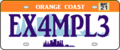 Orange Coast license plate
 -
 Orange Coast state highway shield
 -
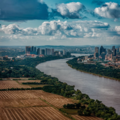 Bronson Vity view
 -
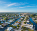 San Bruno view


| | ||
|---|---|---|
| Region: Southeast | Capital: Burton | Population: 2,547,846 |
| Statehood: 1639 Etymology: Derived from native name for "Land of the fish" | Postal code: PA | Largest city: Burton Other population centers: Greenville, Port Mary,Wincheford |
| Neighboring states: Template:Hyde, Oakley, | ||
| Gallery of state symbols | ||
-
 Flag of Passamaqueets
 -
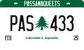 Standard License Plate
 -
 Passamaqueets highway shield
 -
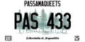 License Plate Variant


| | ||
|---|---|---|
| Region: Massodeya Valley | Capital: Madawan | Population: 5,562,340 (2020) |
| Statehood: 1789 Etymology: Named after being the site of a major mountain pass through the Asphale Mountains | Postal code: PS | Largest city: Catterick Other population centers: Onawanda, Spotswood, Willowbrook |
| Neighboring states: Michisaukee, Ardelia, New Carnaby, AR120-37, Wauseka, Gnaerey | ||
| Gallery of state symbols | ||
-
 Flag of Passitania
 -
 Standard highway shield


| | ||
|---|---|---|
| Region: Southeast | Capital: Warwick | Population: 6,524,249 (2020) |
| Statehood: 1810 (Split from Ruppacke) Etymology: From indigenous population, Pinqiset. Likely derived from the word Pinqi, meaning "Sea", and "Et", meaning "Village". Often translated as "Village by the Sea" or "The Village graced by Navigation". Demonym: Penquot | Postal code: PQ State motto: Venture origin State song: Incandescence | Largest city: Warwick Other population centers: Duxbury, Woodhaven, Beacon, Newburyport |
| Neighboring states: New Carnaby, Ruppacke | ||
| Gallery of state symbols | ||
-
 Flag of Penquisset
 -
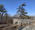 State Tree - Pitch Pine (Pinus Rigida)
 -
 2021-Issued Penquisset license plate
 -
 Standard State Highway Emblem
 -
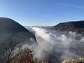
 Terrain of Central Penquisset
 -
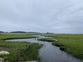 Coastal Penquisset Estuary
 -
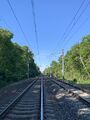 Penquisset Rail Infrastructure
 -
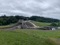 Abundant Water Resources - George Stevens Dam
 -
 Lefferts Bridge over Carnaby River
 -
 Storm King Reservoir
 -
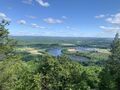
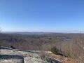 Western Terrain of Penquisset


| | ||
|---|---|---|
| Region: The West | Capital: Colurona | Population: 2,874,000 (2021) |
| Statehood: 1822 Etymology: Poa'ku'iwo peoples Demonym: Riopoderan | Postal code: RS State motto: "Across the mountains and plain, we find ourselves." State song: "Across The Mountains and Plain" | Largest city: Swansonville Other population centers: Las Animas, Porte Springs |
| Neighboring states: | ||
| Gallery of state symbols | ||
-
 Flag of Riopoderos
 -
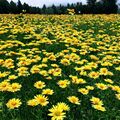 The state flower; The Mountain Sun Daisy
 -
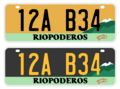 Standard issue license plates
 -
 Primary state highway shield/route marker
 -
 Secondary state highway shield/route marker


| | ||
|---|---|---|
| Region: The West | Capital: Elvira | Population: ~2,500,000 |
| Statehood: 1872 Etymology: Mountain range, Castellanese Demonym: Sierran | Postal code: SR State motto: Totum Mundi (a whole new world) State song: "From the Mountains to the Seas, Sierra Tis of Thee" (1912), "Mi Sierra Bonita" (trad.) | Largest city: Dennison Other population centers: Lola, Chapman |
| Neighboring states: Alcortez, | ||
| Gallery of state symbols | ||
-
 Flag of Sierra
 -
 Seal of Sierra
 -
Grey-hooded Sierra finch, state bird
-
Cassiope mertensiana, state flower
-
Polylepis rugulosa, state tree
-
 Sierran License plates
 -
 Highway shield
 -
Pumice, state rock
-
Red Beryl, state gem
-
Sierran bighorn sheep, state mammal
-
Potato, state vegetable
-
Saccharomyces cerevisiae, state microbe
-
Wrangler hat (felt or straw), state hat
-
 Back side of the flag
.png)


.png)
| | ||
|---|---|---|
| Region: Northwest | Capital: San Pablo | Population: 6,796,240 (2020) |
| Etymology: Unknown Demonym: Tempachian | Postal code: TM State motto: "Omnes Nos Can Operor Illud" ("We All Can Do It") | Largest city: Los Reyes Other population centers: Asperic Beach, Dula, Tesoro |
| Neighboring states: Alcortez, Template:Atascadera, Cosperica | ||
| Gallery of state symbols | ||
-
 Flag of Tempache
 -
State tree of Tempache, the velvet mesquite
-
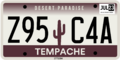 Tempache License Plate (2021-Present)
 -
 Standard state highway shield
 -
 Secondary state highway shield


| | ||
|---|---|---|
| Region: West Lakes | Capital: Conway | Population: 1.600.000 (2020) |
| Statehood: 1828 Etymology: from Venarian Venariteknè, meaning "we, the people near the hills" Demonym: Venarian | Postal code: VE State motto: Venary, the treasure of the south (Venaritenèr, enar milenis) State song: Our Venary, forever (Venaritenèrenis, inekawilpare) | Largest city: Conway Other population centers: Mawkillakin, Three Streams |
| Neighboring states: AR120-56 | ||
| Gallery of state symbols | ||
-
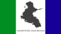 Flag of Venary

| | ||
|---|---|---|
| Region: Massodeyas | Capital: Caldwell City | Population: 4,478,000 (2021) |
| Statehood: 1805 Etymology: Massodeya River Demonym: (West) Massodeyan | Postal code: WM State motto: "United and Free" State song: "Under Open Skies" | Largest city: Caldwell City Other population centers: Reeseport, Fort Graham |
| Neighboring states: | ||
| Gallery of state symbols | ||
-
 Flag of West Massodeya
 -
 Highway shield, standard


| | ||
|---|---|---|
| Region: East Lakes | Capital: Juniper Bay | Population: 3,000,000 (2022) |
| Statehood: 1799 Etymology: Unknown Demonym: Wisecotan | Postal code: WI State motto: La prospérité se forge sur le dos de l'endurance | Largest city: Saigeohn Other population centers: Juniper Bay, Seewachewa, Cambacere, Lakes Crossing |
| Neighboring states: | ||
| Gallery of state symbols | ||
-
 Flag of Wisecota
 -

-
-
 Highway shield, standard
 -
 Highway shield, secondary


| | ||
|---|---|---|
| Region: West Lakes | Capital: Cheviot | Population: 960,026 (2020) |
| Statehood: 1835 Etymology: Derived from Old Ingerish "wych", meaning pliable and supple wood. | Postal code: WY State motto: "Per Deum, Bene valemus" ("Through God, we are well") State song: Prairie Bells | Largest city: Nenova Other population centers: Geoghan |
| Neighboring states: | ||
| Gallery of state symbols | ||
-
 Flag of Wychelle
 -
 Great Seal
 -
Wild pheasant (Phasianus centralis)
-
Laurel goldenrod (Solidago laurus)
-
Ulethan Wych elm (Ulmus archantus)
-
 Highway shield, standard
 -
Southwest Okomeheso County, near Westwick
-
Akogama River, near Goslington


.jpg)
.jpg)
.jpg)
.jpg)
.jpg)
.jpg)
.jpg)
.jpg)
.jpg)