Passamaqueets

|
Passamaqueets Capital: Burton
Population: 2,654,689 (2024) Motto: "Libertatis et aequalitatis" |
Loading map... |
Passamaqueets (/ˌpæsəməˈkɪts/; Pass-uh-ma-KEETS), officially the Commonwealth of Passamaqueets, is a state located in the Cradle Peninsula, located in southeastern Federal States. It borders the Ardentic Ocean and New Carnaby to its north and east, Oakley and Astrantia to its west, and Hyde to its South. Passamaqueets is the smallest state by land area in the constituent Federal States. With a population of 2,547,846 in the latest 2024 census, barely more than the last, it is the most populated state in the peninsula and the Xth most populous state in the country.
Passamaqueets Colony was founded in 1639, with the arrival of many Carthan colonists fleeing persecution from Ingrea in Collintown, modern day Collinfield. The name originated from the Passamaqueet(Passamaquoddy) equivalent of "Land of the fish". In the early 17th century, the settlement of Hampden was founded in the West bank of Orange river, near the Atwick Sound, which ended up failing leading to the foundation of Burton just across the river. At the end of the 18th century, Burton became known as the starting point of the industrial revolution in the Federal States, being what caused the state's main economic activities to shift from trading and fishing to manufacturing industrial products with raw materials from the northern colonies. Over time, the accumulated wealth lead to the creation of many banks and one of the most prestigeous medical universities in the country, the Passamaqueets Medicine College, located in Northill, Burton.
Burton is the major economical hub, capital and population center of the state. Port Mary and Greenville are the only other two municipalities with city status in Passamaqueets, which act as exurbs of Burton, and Miaconda for Port Mary. The metropolitan area of Burton composes most of the state's economy and demographics, sprawling into Hyde, and most of the state, also being part of the greater southeast megalopolis. The historical background of Passamaqueets lead to the current 76.4% Ortholic population, marking the state's culture being slightly more conservative socially amongst its neighbors while retaining a simillar political makeup.
Due to the high investments in the education sector and high urban population, it ranks in the top ten for median income per household in the nation, *GDP per capita*, and education, having 39% of the population with a bachelor's degree or an advanced degree, increasing every year as more retirees without degrees move out of the state, with an influx of college students. Overall Passamaqueets has seen a stagnation in population growth, as the birth rate is already low with high amounts of families leaving the state.
Etymology
The Passamaqueets Colony was named after the native tribe which had the first interaction with ulethans in the Cradle peninsula, the Passamaqueet or 'Pesskmuhkati'. The name is derived from the phrase "the place with many fish" said during the first interaction, the area referred was likely at the mouth of the orange river, where the modern day city of Burton is. The mouth of the river had many shallow tidal banks which were left with many fish during low tides, in the modern day, all of the shallower parts of the river have been covered in landfill.
History
Colonial Period
Independence
Industrial Revolution
20th Century
Modern Day
Geography
Climate
Demographics
Population Density
Race and Ancestry
- Mostly Cambrian (Tircambry) and Pleviannic, followed by Ingrean and OGF:Latin Americans
HDI
0.928
Education
PSMC
PSU
BSU
Economy
Poorer than Massachusetts/Richer than Pennsylvania
Infrastructure
Transportation
Possible Cradle exclusive transportation thing? - CRR (Cradle Railroad)/CRTA (Cradle Transportation Authority)
PSTA
Passamaqueets State Transportation Authority
Toll ban
Energy Production
Nuclear: 1 power plant -> 1,200MW -> 9,460GWhtotal: 6,000 MW production (26,280 GWh)
Hydro: Many plants; Wauhegan->1.5 GWh -> 5,256GWh total (20%)
Ferries
Government and Politics
| Government of Passamaqueets | |
|---|---|
|
| |
| Government type | Representative democracy |
| Capital | Burton |
| Head of state | |
| • Governor Jessica Parker (Unionist) | |
| • Lieutenant Governor James Mayfield (Unionist) | |
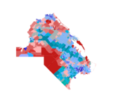
 2022 Gubernatorial election breakdown by precinct | |
| Legislature | |
| • Type Bicameral | |
| • Upper house State Senate | |

| |
| • Lower house | General Assembly |

| |
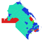
 Lower house map by constituency | |
| Judiciary | Passamaqueets Supreme Court |
| Major political parties | |
|
Federalist Party DOP Unionist Party Green Party New Unionist Party Labor Party
| |
2023 Presidential Election
6EVs 4 districts
2022 Gubernatorial Election
__________________________________________________________________________________
Cities, Towns and Counties
- no townships
Counties
| County | Seat | Population (2020) |
Total area (mi²) | Land area (mi²) | Density (in sqmi) |
Year established |
|---|---|---|---|---|---|---|
| Norfric County | Burton | 883,301 | 88.065 | 60.683 | 14,556 | 1640 |
| Hampstead County | Collinfield | 817,510 | 214.767 | 193.677 | 4,221 | 1639 |
| Sufric County | Greenville | 407,535 | 605.445 | 238.121 | 1,711 | 1667 |
| Newport County | Port Mary | 260,783 | 514.138 | 323.513 | 806 | 1669 |
| Passawk County | Larwick | 138,671 | 441.628 | 367.439 | 337 | 1669 |
| Southborough County | Wincheford | 146,889 | 467.816 | 467.816 | 314 | 1823 |
| Passamaqueets | 2,654,689 | 2331.859 | 1649.86 | 1,609 | 1639 |
Largest cities
Largest cities
| Municipality | Type | County | Population (2020) |
Total area | Land area | Year established |
|---|---|---|---|---|---|---|
| Burton | City (Capital city) | Norfric (seat) | 810,310 | 1641 | ||
| Greenville | City | Sufric (seat) | 121,984 | 1765 | ||
| Wincheford | City | Southborough (seat) | 115,217 | 1796 | ||
| Port Mary | City | Newport (seat) | 101,636 | 1669 | ||
| Southbrook | Town | Hampstead | 73,940 | 1705 | ||
| Springfield | Town | Sufric | 66,239 | 1746 | ||
| Otisport | City | Sufric | 63,284 | 1698 | ||
| Amesboro | Town | Sufric | 62,527 | 1708 | ||
| Rochester | Town | Sufric | 56,527 | 1688 | ||
| Cranwhark | Town | Newport | 54,785 | 1689 | ||
| Collinfield | Town | Hampstead (seat) | 53,832 | 1639 (Oldest) | ||
| Windsor | Town | Norfric | 53,605 | 1651 | ||
| Langley | Town | Sufric | 50,212 | 1724 | ||
| Statesboro | Town | Sufric | 48,436 | 1667 | ||
| Worthfield | Town | Sufric | 44,846 | 1675 | ||
| Chesterfield | Town | Hampstead | 40,646 | 1693 | ||
| Rockford | Town | Hampstead | 38,913 | 1659 | ||
| Larwick | Town | Passawk (seat) | 38,913 | 1699
|
Culture
Health and Medical Institutions
Sports
//ignore: big hockey state|big basketball state|ok football state//
References
123456789
See also
| States |
Alcortez • |
|---|---|
| Capital District | Huntington(c) |
| Overseas Territories | |