Riopoderos: Difference between revisions
Rustem Pasha (talk | contribs) m (category) |
Geoc3ladus (talk | contribs) No edit summary |
||
| (11 intermediate revisions by 2 users not shown) | |||
| Line 1: | Line 1: | ||
{{Infocard FS | |||
| name = State of Riopoderos | |||
| flag = New_Riopoderos_flag.png | |||
| symbol = | |||
| symbol_caption = | |||
| native_name = | |||
| native_language = | |||
| capital = Colurona | |||
| population = 2,874,000 | |||
| population_year = 2021 | |||
| motto = "Across the mountains and plain, we find ourselves." | |||
| anthem = "Across The Mountains and Plain" | |||
| latitude = -35.278 | |||
| longitude = 142.038 | |||
| zoom = 6 | |||
| relation = 90158 | |||
| intro = '''Riopoderos''', officially the '''State of Riopoderos''', is a state in the Heartland Region of the [[Federal States of Archanta]]. Riopoderos is bordered by [[Sierra]] to the north, [[Apawiland]] to the northeast, AR120-42 to the east, [[Tennewa]] to the south, [[Wychelle]] to the southwest, and [[Clamash]] to the west. The name Riopoderos is a portmanteau of the Castellanese "rio," and the Castellanese derivative of the Poa'ku'iwo word '''poderaa''', which rougly translates to "golden fields." Riopoderos features vast river valleys, mountains, coniferous forests, and open plains/prairies. The capital of Riopoderos is [[Colurona]], named after the Colurona River Valley, where the city is situated. The largest city in Riopoderos is [[Swansonville]], situated on the Quinn River on the eastern plains. | |||
}} | |||
{{FS Infobox state | {{FS Infobox state | ||
|coords_zoom = | |coords_zoom = | ||
|coords_x = | |coords_x = | ||
|coords_y = | |coords_y = | ||
|coords_layer = | |coords_layer = | ||
|common_name = Riopoderos | |common_name = Riopoderos | ||
| Line 9: | Line 28: | ||
|image_flag = New_Riopoderos_flag.png | |image_flag = New_Riopoderos_flag.png | ||
|image_coat = | |image_coat = | ||
|national_motto = | |national_motto = Across the mountains and plain, we find ourselves. | ||
|english_motto = | |english_motto = | ||
|capital = [[Colurona]] | |capital = [[Colurona]] | ||
|largest_city = [[Swansonville]] | |largest_city = [[Swansonville]] | ||
|official_languages = | |official_languages = Ingerish | ||
|demonym = Riopoderan | |demonym = Riopoderan | ||
|government_type = | |government_type = | ||
|leader_title1 = Governor | |leader_title1 = Governor | ||
|leader_name1 = [[Robert McMain]] | |leader_name1 = [[Robert McMain]] | ||
| Line 23: | Line 42: | ||
|upper_house = State Senate | |upper_house = State Senate | ||
|lower_house = State House | |lower_house = State House | ||
|area_km2 = | |area_km2 = 75,466.18 | ||
|area_sq_mi = | |area_sq_mi = 29,137.65 | ||
|percent_water = | |percent_water = <1% | ||
|population_census = | |population_census = 2,874,000 | ||
|population_density_km2 = | |population_density_km2 = 36.89 | ||
|population_density_sq_mi = | |population_density_sq_mi = 95.55 | ||
|timezone = [[World Time|9+]] | |timezone = [[World Time|9+]] | ||
}} | }} | ||
<gallery> | |||
File:Mountain Sun Daisy.jpg|<center> Field of Mountain Sun Daisies, the state flower. | |||
File:Riopoderos License Plates.png|<center> | |||
File:Riopoderos State Route Shield Primary.png|<center> Primary Route Marker | |||
File:Riopoderos State Route Shield Secondary.png|<center> Secondary Route Marker | |||
</gallery> | |||
=Etymology= | |||
=History= | =History= | ||
== | =Geography= | ||
= | =Government= | ||
==Administrative Subdivisions== | |||
===List of Counties=== | |||
Riopoderos has 23 Counties and XX Townships. | |||
{| class="wikitable" | |||
|+ | |||
!County Name | |||
!County Seat | |||
!Population | |||
!Area (km<sup>2</sup>) | |||
!Area (mi<sup>2</sup>) | |||
!Number of Townships | |||
|- | |||
|[https://opengeofiction.net/relation/261012#map=10/-34.5269/144.4029&layers=B Robinson County] | |||
|Sathemine | |||
| | |||
| | |||
| | |||
|10? | |||
|- | |||
|[https://opengeofiction.net/relation/261016#map=10/-34.9133/144.4027&layers=B Modesto County] | |||
|Lehigh | |||
| | |||
| | |||
| | |||
|12 | |||
|- | |||
|[https://opengeofiction.net/relation/261014#map=10/-35.2383/144.4029&layers=B Richmond County] | |||
|Windfort | |||
| | |||
| | |||
| | |||
| | |||
|- | |||
|[https://opengeofiction.net/relation/262970#map=10/-35.5719/144.4043&layers=B Wakefield County] | |||
|Saint Harvey | |||
| | |||
| | |||
| | |||
| | |||
|- | |||
|[https://opengeofiction.net/relation/280859#map=10/-35.9991/144.2079&layers=B Yarrow County] | |||
|Elsinore | |||
| | |||
| | |||
| | |||
| | |||
|- | |||
|[https://opengeofiction.net/relation/262969#map=10/-35.5713/144.0225&layers=B Dowell County] | |||
|Cookfield | |||
| | |||
| | |||
| | |||
| | |||
|- | |||
|[https://opengeofiction.net/relation/261013 Lynott County] | |||
|Aldena | |||
| | |||
| | |||
| | |||
| | |||
|- | |||
|[https://opengeofiction.net/relation/261015 Boulder County] | |||
|[[Swansonville]] | |||
| | |||
| | |||
| | |||
| | |||
|- | |||
|[https://opengeofiction.net/relation/232263#map=10/-34.6027/143.8646&layers=B Bronson County] | |||
|Apawi | |||
| | |||
| | |||
| | |||
| | |||
|- | |||
|[https://opengeofiction.net/relation/232459#map=11/-34.9557/143.7609&layers=B Mooreland County] | |||
|Norwick | |||
| | |||
| | |||
| | |||
| | |||
|- | |||
|[https://opengeofiction.net/relation/305072#map=10/-35.3185/143.5350&layers=B Geraldine County] | |||
|Maskonee City | |||
| | |||
| | |||
| | |||
| | |||
|- | |||
|[https://opengeofiction.net/relation/305071 Knockaert County] | |||
|Tennewa Springs | |||
| | |||
| | |||
| | |||
| | |||
|- | |||
|[https://opengeofiction.net/relation/305070 Sullivan County] | |||
|Merryman | |||
| | |||
| | |||
| | |||
| | |||
|- | |||
|[https://opengeofiction.net/relation/273691 McHale County] | |||
|Fort Gerryman | |||
| | |||
| | |||
| | |||
| | |||
|- | |||
|[https://opengeofiction.net/relation/272487 Douglas County] | |||
|Wayneright | |||
| | |||
| | |||
| | |||
| | |||
|- | |||
|[https://opengeofiction.net/relation/249289 Jones County] | |||
|Midway | |||
| | |||
| | |||
| | |||
| | |||
|- | |||
|[https://opengeofiction.net/relation/282262#map=9/-35.9707/142.2887&layers=B Hessonite County] | |||
|Porte Springs | |||
| | |||
| | |||
| | |||
| | |||
|- | |||
|[https://opengeofiction.net/relation/246235 Bronze County] | |||
|Bronze River | |||
| | |||
| | |||
| | |||
| | |||
|- | |||
|[https://opengeofiction.net/relation/246236#map=10/-34.9940/141.3309&layers=B Rose County] | |||
|Redding | |||
| | |||
| | |||
| | |||
| | |||
|- | |||
|[https://opengeofiction.net/relation/246237 Winston County] | |||
|Estancia | |||
| | |||
| | |||
| | |||
| | |||
|- | |||
|[https://opengeofiction.net/relation/246239 Frontier County] | |||
|Colurona | |||
| | |||
| | |||
| | |||
| | |||
|- | |||
|[https://opengeofiction.net/relation/246240 Planos County] | |||
|Maddison | |||
| | |||
| | |||
| | |||
| | |||
|- | |||
|[https://opengeofiction.net/relation/246234 Floyd County] | |||
|Ross Springs | |||
| | |||
| | |||
| | |||
| | |||
|} | |||
===List of Municipalities=== | |||
= | =Economy= | ||
= | =Tourism= | ||
=Education= | |||
=Transportation= | |||
= References= | |||
{{Political divisions of the Federal States}} | {{Political divisions of the Federal States}} | ||
[[Category:Riopoderos]] | |||
[[Category:States of the Federal States]] | |||
Latest revision as of 17:50, 23 January 2024

|
State of Riopoderos Capital: Colurona
Population: 2,874,000 (2021) Motto: "Across the mountains and plain, we find ourselves." |
Loading map... |
Riopoderos, officially the State of Riopoderos, is a state in the Heartland Region of the Federal States of Archanta. Riopoderos is bordered by Sierra to the north, Apawiland to the northeast, AR120-42 to the east, Tennewa to the south, Wychelle to the southwest, and Clamash to the west. The name Riopoderos is a portmanteau of the Castellanese "rio," and the Castellanese derivative of the Poa'ku'iwo word poderaa, which rougly translates to "golden fields." Riopoderos features vast river valleys, mountains, coniferous forests, and open plains/prairies. The capital of Riopoderos is Colurona, named after the Colurona River Valley, where the city is situated. The largest city in Riopoderos is Swansonville, situated on the Quinn River on the eastern plains.
| State of Riopoderos Riopoderos Estado de Riopoderos | |||
|---|---|---|---|
| |||
| Constituent state of | |||
| Capital | Colurona | ||
| Largest city | Swansonville | ||
| Official languages | Ingerish | ||
| Demonym | Riopoderan | ||
| Government | |||
| • Governor | Robert McMain | ||
| • Lieutenant Governor | Sarah Calahan | ||
| Legislature | State Assembly | ||
| • Upper house | State Senate | ||
| • Lower house | State House | ||
| Area | |||
| • Total | 75,466.18 km2 29,137.65 sq mi | ||
| • Water (%) | <1% | ||
| Population | |||
| • Census | 2,874,000 | ||
| • Density | 36.89/km2 95.55/sq mi | ||
| Timezone | 9+ | ||
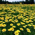
Field of Mountain Sun Daisies, the state flower. 
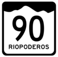
Primary Route Marker 
Secondary Route Marker


Etymology
History
Geography
Government
Administrative Subdivisions
List of Counties
Riopoderos has 23 Counties and XX Townships.
| County Name | County Seat | Population | Area (km2) | Area (mi2) | Number of Townships |
|---|---|---|---|---|---|
| Robinson County | Sathemine | 10? | |||
| Modesto County | Lehigh | 12 | |||
| Richmond County | Windfort | ||||
| Wakefield County | Saint Harvey | ||||
| Yarrow County | Elsinore | ||||
| Dowell County | Cookfield | ||||
| Lynott County | Aldena | ||||
| Boulder County | Swansonville | ||||
| Bronson County | Apawi | ||||
| Mooreland County | Norwick | ||||
| Geraldine County | Maskonee City | ||||
| Knockaert County | Tennewa Springs | ||||
| Sullivan County | Merryman | ||||
| McHale County | Fort Gerryman | ||||
| Douglas County | Wayneright | ||||
| Jones County | Midway | ||||
| Hessonite County | Porte Springs | ||||
| Bronze County | Bronze River | ||||
| Rose County | Redding | ||||
| Winston County | Estancia | ||||
| Frontier County | Colurona | ||||
| Planos County | Maddison | ||||
| Floyd County | Ross Springs |
List of Municipalities
Economy
Tourism
Education
Transportation
References
| States | Alcortez • |
|---|---|
| Capital District | Huntington(c) |
| Overseas Territories | |