Kofuku

|
Kofuku  Kofuku Landneuron (Darrsyan) |
Loading map... |
Kofuku (Officially Kofuku Federation or Kofuku Landneuron) is a very mountainous country located on the austral side of Antarephia. In the center of what is known as the Harda Archipelago.
Bako-Huz is the capital city and it is located in the northern part of the country. The total population is around 11 million inhabitants, with a population density of 41 hab/km² on it's 262 760 km² of land area.
It borders three countries by land: Kalisänjo, Sulro, San Juan de Castellán. And AN160 by a sea border. The main language spoken is Ingerish and the native language Darrsyan.
| |||||
| Kofuku relation∈⊾ | |||||
| Kofuku Federation Kofuku Landneuron | |||||
|---|---|---|---|---|---|
| |||||
Loading map... | |||||
| Motto: "no official motto" | |||||
| Capital | Bako-Huz | ||||
| Official languages | Ingerish and Darrsyan | ||||
| • Regional languages | Oderens | ||||
| Demonym | Kofuken | ||||
| Government | Federation | ||||
| • Chancellor | Enryk Martynjo of Ter | ||||
| Area | |||||
| • Total | 262760 km2 101452 sq mi | ||||
| Population | |||||
| • Estimate | 11023540 | ||||
| GDP (PPP) | 2022 | ||||
| • Total | 561 billions | ||||
| • Per capita | 50920 | ||||
| HDI (2020) | very high | ||||
| Timezone | WUT + 4 h | ||||
| Currency | Antari (₳ or ANT) | ||||
| Drives on the | right | ||||
Etymology
The name Kofuku comes from Ancient Darrsyan: “Kuĥoku” that means “around us”. Through the centuries the letter “o” and the first “u” were switched, passing from Kuĥoku to Koĥuku. In 1210 the king of Darrsya named Kostadorr Krek was unable to pronounce the Ĥ letter and announced a language reform where all letters Ĥ should be replaced with F. This rule was later reverted but some words such as Kofuku stayed with the new F letter.
| History of Kofuku | |
|---|---|
| Prehistory & Antehom Age | 2000BC - 340AD |
| • Prehistory | 2000BC |
| • Greeko Kingdom (Amekumys) | 1000BC - 500BC |
| • Austrond Civilisation | 800BC - 300BC |
| • Darrsyan Empire | 305BC - 340AD |
| Medieval & Colonial Times | 340 - 1745 |
| • Vinn Immigration | XIII Century |
| • Bergensen Norskers Raids | XIV - XV Centuries |
| • Monolitzh Empire | 1421 |
| • Colonial Period | 1745 - 1815 |
| Post-Colonial | After 1815 |
| • Golden Era | 1815 - 1921 |
| • Industrial Revolution | |
| • Red Star (Communist Period) | 1921 - 1978 |
| • Current Times | After 1978 |
History
Prehistory & Antehom Age 2000BC-340AD
Prehistory
The early remains of ancient Kofuku go back until the year 2000BC. The population was formed by tribes of hunters and gatherers. It is believed that these lands could hold humans many years before but there are no evidences of this.
In the 2000BC the main tribes such as the May-Kuru, the Asontes, or the Merynenses, were settled mainly on the fertile valleys and coasts.
Greeko Kingdom 1000BC-500BC
Approximately on the year 1000BC it is known that a branch of the May-Kuru tribe, called Mekunos, started taming animals and using them for the agricultural hard work. The Mekuno people formed the Greeko Kingdom with capital in Amekumys (Later called Anecumis) The Greeko Kingdom started growing their influence to the rest of the tribes and soon small kingdoms were formed all across the area of current Kofuku.
The Greeko Kingdom formed colonial cities across Kofuku. From 900BC to 600BC it also built a large network of roads connecting the main cities of Kofuku.
The rest of territory that wasn’t under Greeko Dominance was formed by city-states. Mainly administered by the inhabitants in a communitarian way. This is the idea that inspired the current system used in the administration of Kofuku municipalities.
Austrond Civilisation 800BC-300BC
At the same time in northern Kofuku we find the Austrond Civilisation. The ancestors of the Bergensen Norskers Civilisation. Those were aggressive city-states with constant conflicts. The main city of this civilisation was Nykilnø.
Around the year 500BC the concept of imperialism appears in Kofuku. Many empires emerged on the following years. The first one was the Narfysk Empire that occupied all the valley in which it emerged.
Darrsyan Empire 305BC-340AD
The most powerful empire was the Darrsyan Empire that emerged on Metrocolis at the year 305BC.

The Emperor Sejve started the empire with a massive conquest campaign. After ten years he was able to unify the whole Kofuku under his empire. He died murdered on the year 294BC. After dying, his corpse was moved from Brendan to a hill by the Andel River (currently Andelimouth) where he currently rests in his mausoleum. Because of the leader’s death, the empire stopped expanding. The Darrsyan Empire continued existing until its colapse on the year 340AD.
The empire also managed to make infrastructure and commerce across its territory. The Antehom Age ends with the collapse of the Darrsyan Empire.
Medieval Times 340-1745
Vinn area immigration (XIII Century)
Bergensen Norskers
Monolitzh Empire

- 1420 The crown of Anecumis declares war to Serwak
- 1421 Revolution against the crown of Anecumis. Monolitzh Kingdom is formed
- Norok of Holvo turns the Monolitzh Kingdom into an empire and starts expansion campaigns in 1425
- 1430 Monolitzh Empire conquers Metrocolis
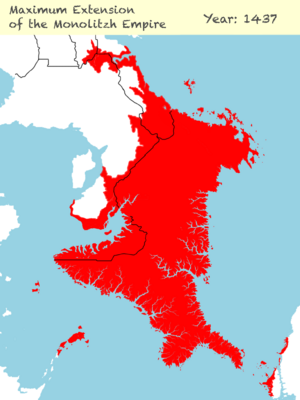
- 1437 The Monolitzh Empire reaches its maximum size
- 1451 The First Harda War starts. Monolithz looses territories in Northern Harda
Colonial Period 1745-1815
Origins of the Colony

Before the Empire of Ingrea turned Kofuku into a colony, the territory had suffered several years of very bad harvests. The population was in a famine and Ingrea took the chance of acquiring the control over Kofuku.
Diplomats of Ingrea promised to supply the country of food brought by their other colonies. The regions of the north accepted, and seeing that they kept the promise, the rest of regions also joined. In the 5th of March of 1745 the last region (Nordoska) agreed and a new Ingerish colony starts under the official name of “Royal Overseas Region of Kofuku”.
The Ingerish Empire wanted to rapidly integrate the culture and language. They were successful on integrating the language which is currently the most used in Kofuku. Still, the Kofuku culture did resisted. Although it also took parts of Ingerish and Ulethan culture.
Ingerish Immigration
San Juan de Castellán -1772- Nordhardia War
Castellán also formed part of the process of colonisation. Tárrases was a colony of Castellán already. Ingrea had more colonies around and managed to block the passing of castellanese boats through the Nordhardian Sea, the sea north of the Harda Archipelago.
Castellán, being surrounded, was forced to answer and started the Nordhardian War. In this war Ingrea lost the block to Castellán but managed to keep all their colonies under their rule. Castellán was able to only conquer a really small island on the Kofuken coast which they named San Juan de Castellán. Castellán didn’t used it as a colony but as one more piece of the mainland territory of the colonial power. The island was used as a resting point and supply port between Tarrases and the rest of the Castellanese empire.
Independence Revolution 1814-1815

In 1813 the Ingerish Empire started a campaign of more strict governance in the colony. Increasing taxes, erasing all independent organisations, and banning the Darrsyan language. These restrictions created a wave of anger across the population. Enforcing them with a brutal use of violence by the government. The idea of revolution started growing popularity until 1814 when the revolution took place. Ingerish-loyal settlers were persecuted and the main governors hanged.
The revolution was trigged by the manifesto of Mark Yado, a son of Huaxia immigrants. He is considered along with Sejve Emperor as the founding fathers of Kofuku. Mark Yado created a committee in the main cities of the colony from where the revolution was managed.
The Ingerish Empire sent in 1815 10000 soldiers to the shores of Kofuku. In response, the Castellanese Empire aided the young nation by providing strong naval force. On the 20th of February the Ingerish ships arrived to the Firefly beach, just 4 kilometres east of Bako-Huz (at the time). The Castellanese fleet was hidden on the South Sunday natural port. As the enemy ships started unloading the soldiers and cannons, the Castellanese navy arrived to the site and started bombing the Ingerish ships from the sea. They were trapped and quickly defeated by sea. By having lost the navy, it was just a matter of time from the on-shore soldiers to surrender to the scarce Kofuken army.
Golden Era 1815-1921

This time era is commonly referred to as the Golden Age of Kofuku. On this time the previous colony was transformed in a short amount of time. Following the main Uletha powers, such as Kalm, Ingrea, Castellan, and Suria. The royal house of "The Vinnen" had the control of the nation, making it a kingdom until the year 1921. On this year, a communist revolution on the main cities of the nation forced the royal house to flee towards northern Harda.
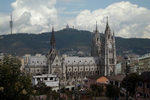
This era left an architectural Gothic Revival legacy as well as a rapid increase of population following the arrival of the Industrial Revolution.
Red Star (Communist Period) 1921-1978
Around the 1910s, a new political and social ideology called "Narfism" started taking power over the kofuken worker's population. This ideology brought back the values of the pre-colonial times, against the curren uletha-based culture. The new values included the revive of the native Darrsyan language, the social life in communities, and a decentralised political system.
The Narfism ideology took advantage of the communism waves across Uletha to bring a revolution to Kofuku. In 1921 the kingdom was overthrown in peaceful ways by storming the palaces with revolutionary armies led by communist leaders. The royal family fled to northern Harda and the army proclaimed a new governance called the "Red Star". Each region proclaimed self-governance and allied with the other regions for a common army against external threats.
Under this period, most of Kofuken base-infrastructure was built, along with quickly surging industries. Most cities saw a quick growth in population, by the rural-to-cities migrations. Being Bako-Huz the capital of the old colony and kingdom, in 1930 the Darrsya Region government decided to develop Metrocolis as the new capital city for Kofuku. The city where the Darrsyan language and empire started. Considered as well as the funding city of Kofuku. It was planned following the Architectural Modernism and CIAM values (just as many other communist nations such as Suria or Banuvia). In 1978 Bako-Huz was again established as capital city.
In 1964 all these independent regions founded an alliance with other Antarephian nations for military and economical support. Giving birth to the Antarephian Coalition.
Current Times 1978-now
In the 1970s the nation saw a slow progress into a more centralised government. In which instead of independent regions with a common army, the country of Kofuku would again be stablished as a whole. Keeping federalism as the new in-between type of government. The "Unification Committee" was established by support of most regions. This Committee made arrangements with all regions until in 1978 the new federal type of government saw the light. Having the first national elections in 1979.
Politics
Embassies and International Relations
Government
| Government of Kofuku | |
|---|---|
| Federation | |
| Capital | Bako-Huz |
| Head of state | |
| • Chancellor | Enryk Martynjo of Ter |
| • Regional Representatives | 3 for each region (30 total) |
| Legislature | |
| • Upper house | National Senate |
| • Lower house | People's Palace |
| Judiciary | National Supreme Court |
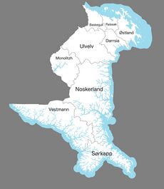
| Federation | The Federation is divided into 10 States which directly control the Federal Parliament |
Major political parties | |
Banned in Kofuku | |
| AN, AC | |
 | |
|---|---|
| Administrative divisions of Kofuku Federation | |
| First-level | Region |
| Second-level | Kommune |
| Third-level | Municipality |
| Flag | Region | Capital | Kommunes | Land area Km² | Population | Population density hab/Km² |
|---|---|---|---|---|---|---|
| Darrsya∈⊾ | Metrocolis | 14 403 | 2 363 560 | 164 | ||
| Rayssak∈⊾ | Bako-Huz | Bako-Huz, Leysenkliflands, Sunlands, Bergensenlands, Kazatxoklands, Øyselands, Ørenlands, R1 | 6 827 | 1 830 400 | 268 |


