Riopoderos: Difference between revisions
Geoc3ladus (talk | contribs) mNo edit summary |
Geoc3ladus (talk | contribs) |
||
| Line 86: | Line 86: | ||
|[https://opengeofiction.net/relation/261012#map=10/-34.5269/144.4029&layers=B Robinson County] | |[https://opengeofiction.net/relation/261012#map=10/-34.5269/144.4029&layers=B Robinson County] | ||
|Sathemine | |Sathemine | ||
| | |||
| | |||
| | |||
|- | |||
|[https://opengeofiction.net/relation/478348 Cascade County] | |||
|Cascade | |||
| | | | ||
| | | | ||
| Line 97: | Line 103: | ||
|- | |- | ||
|[https://opengeofiction.net/relation/261014#map=10/-35.2383/144.4029&layers=B Richmond County] | |[https://opengeofiction.net/relation/261014#map=10/-35.2383/144.4029&layers=B Richmond County] | ||
| | |Woodward | ||
| | | | ||
| | | | ||
| | | | ||
|- | |- | ||
|[https://opengeofiction.net/relation/262970#map=10/-35.5719/144.4043&layers=B | |[https://opengeofiction.net/relation/262970#map=10/-35.5719/144.4043&layers=B Kinnowa County] | ||
|Kinnowa Forks | |Kinnowa Forks | ||
| | | | ||
| Line 114: | Line 120: | ||
| | | | ||
|- | |- | ||
|[https://opengeofiction.net/relation/262969#map=10/-35.5713/144.0225&layers=B | |[https://opengeofiction.net/relation/262969#map=10/-35.5713/144.0225&layers=B Cook County] | ||
|Cookfield | |Cookfield | ||
| | | | ||
| Line 120: | Line 126: | ||
| | | | ||
|- | |- | ||
|[https://opengeofiction.net/relation/261013 | |[https://opengeofiction.net/relation/261013 Ford County] | ||
|Aldena | |Aldena | ||
| | | | ||
| Line 132: | Line 138: | ||
| | | | ||
|- | |- | ||
|[https://opengeofiction.net/relation/232263#map=10/-34.6027/143.8646&layers=B | |[https://opengeofiction.net/relation/232263#map=10/-34.6027/143.8646&layers=B Gellard County] | ||
|Apawi | |Apawi | ||
| | | | ||
| Line 144: | Line 150: | ||
| | | | ||
|- | |- | ||
|[https://opengeofiction.net/relation/305072#map=10/-35.3185/143.5350&layers=B | |[https://opengeofiction.net/relation/305072#map=10/-35.3185/143.5350&layers=B Colfax County] | ||
|Maskonee City | |Maskonee City | ||
| | | | ||
| Line 152: | Line 158: | ||
| [https://opengeofiction.net/relation/305071 Knockaert County] | | [https://opengeofiction.net/relation/305071 Knockaert County] | ||
|Tennewa Springs | |Tennewa Springs | ||
| | | | ||
| | | | ||
| Line 163: | Line 163: | ||
|- | |- | ||
|[https://opengeofiction.net/relation/273691 McHale County] | |[https://opengeofiction.net/relation/273691 McHale County] | ||
| | |Hanoke | ||
| | | | ||
| | | | ||
| Line 194: | Line 194: | ||
|[https://opengeofiction.net/relation/246236#map=10/-34.9940/141.3309&layers=B Rose County] | |[https://opengeofiction.net/relation/246236#map=10/-34.9940/141.3309&layers=B Rose County] | ||
|Redding | |Redding | ||
| | |||
| | |||
| | |||
|- | |||
|[https://opengeofiction.net/relation/478347 Stafford County] | |||
|Passiondale | |||
| | | | ||
| | | | ||
Revision as of 18:16, 5 August 2025

|
State of Riopoderos Capital: Colurona
Population: 2,874,000 (2021) Motto: "Across the mountains and plain, we find ourselves." |
Loading map... |
Riopoderos, officially the State of Riopoderos, is a state in the Heartland Region of the Federal States of Archanta. Riopoderos is bordered by Sierra to the north, Apawiland to the northeast, Des Plaines to the east, Tennewa to the south, Wychelle to the southwest, and Clamash to the west. The name Riopoderos is a portmanteau of the Castellanese "rio," and the Castellanese derivative of the Poa'ku'iwo word "pwō-deráa", which rougly translates to "the colorful plain." Riopoderos features vast river valleys, mountains, coniferous forests, and open plains/prairies. The capital of Riopoderos is Colurona, named after the Colurona River Valley, where the city is situated. The largest city in Riopoderos is Swansonville, situated on the Quinn River on the eastern plains.
| State of Riopoderos Riopoderos Estado de Riopoderos | |||
|---|---|---|---|
| |||
| Constituent state of | |||
| Capital | Colurona | ||
| Largest city | Swansonville | ||
| Official languages | Ingerish | ||
| Demonym | Riopoderan | ||
| Government | |||
| • Governor | Robert McMain | ||
| • Lieutenant Governor | Sarah Calahan | ||
| Legislature | State Assembly | ||
| • Upper house | State Senate | ||
| • Lower house | State House | ||
| Area | |||
| • Total | 75,466.18 km2 29,137.65 sq mi | ||
| • Water (%) | <1% | ||
| Population | |||
| • Census | 2,874,000 | ||
| • Density | 36.89/km2 95.55/sq mi | ||
| Timezone | 9+ | ||
-
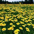
Field of Mountain Sun Daisies, the state flower. -

Standard-Issue license plates -
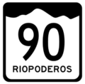
State Highway Shield


History & Etymology
Pre-Ulethan Settlement
Historians' leading theory suggests that the name "Riopoderos" is a mistranslated Poakuiwo phrase. The phrase in question, "pwō-deráa", translates roughly to "the colorful plain." In the latter 16th century, prior to Ulethan settlement, the Poakuiwo and the neighboring Maskonee peoples formed a confederation that spanned most of modern day eastern Riopoderos, western Des Plaines, and far South Apawiland. In the western half of the state, the Planos tribes formed a similar confederation that spanned most of the lower Colurona Valley.
Castellanese Exploration
The 18th century saw the era of Ulethan Exploration around the globe. The lands of the now Federal States would become some of the first infant colonies of the growing Valonian and Castellanese empires. Castellán established the colony of Esperanza in the now state of Cosperica
The Effesian Westward Expansion
Geography
Government
Administrative Subdivisions
List of Counties
Riopoderos has 23 Counties and XX Townships.
| County Name | County Seat | Population | Area (km2) | Area (mi2) |
|---|---|---|---|---|
| Robinson County | Sathemine | |||
| Cascade County | Cascade | |||
| Cramer County | Lehigh | |||
| Richmond County | Woodward | |||
| Kinnowa County | Kinnowa Forks | |||
| Yarrow County | Elsinore | |||
| Cook County | Cookfield | |||
| Ford County | Aldena | |||
| Boulder County | Swansonville | |||
| Gellard County | Apawi | |||
| Mooreland County | Norwick | |||
| Colfax County | Maskonee City | |||
| Knockaert County | Tennewa Springs | |||
| McHale County | Hanoke | |||
| Douglas County | Wayneright | |||
| Jones County | Midway | |||
| Hessonite County | Porte Springs | |||
| Bronze County | Bronze River | |||
| Rose County | Redding | |||
| Stafford County | Passiondale | |||
| Winston County | Nawshanee | |||
| Frontier County | Colurona | |||
| Planos County | Maddison | |||
| Floyd County | Ross Springs |
Economy
Tourism
Education
Transportation
References
| States |
Alcortez • |
|---|---|
| Capital District | Huntington(c) |
| Overseas Territories | |